The best hikes in Peru: our top picks

Select Month

plan my trip

Peru’s treks follow ancient Inca routes like the Qhapaq Ñan, with paths that wind past high peaks, cloud forests, and centuries-old stonework. There are 37 mountains over 20,000 feet (6,000 meters) here. At the top of Huascarán Sur, gravity is weaker than anywhere else on Earth— if you visit here, you’ll actually weigh a little less. This is a country you can continue to visit and find new places. Here’s our pick of the best of Peru’s hikes. 
 

Inca Trail (Cusco)

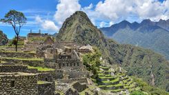
The Inca Trail is a 26-mile (42-kilometer) trekking route built by the Incas that leads directly to Machu Picchu, and is an obvious choice for one of the best hikes in Peru. It's a four-day hike that passes through mountain passes, cloud forest, and several Inca ruins you can only reach on foot. The trail ends at the Sun Gate, where you get your first view of Machu Picchu from above. 

You’ll climb to Dead Woman’s Pass, the highest point on the trail, at 13,828 feet (4,215 meters). It’s a tough section, but most people with reasonable fitness can handle it, especially if they’ve acclimatized. The trail passes through a mix of microclimates and terrain, and the stonework is a clear reminder of how skilled Inca engineering really was. It's easily one of the best things to do in Cusco.

Permits are capped at 500 per day, including guides and porters, so they sell out fast. You’ll need to book several months ahead—especially during the dry season.

How to get to Inca Trail

Trips usually begin in Cusco. From there, you’ll head to Ollantaytambo in the Sacred Valley and take the train to KM 82 (Piscacucho), the trailhead. All treks must be done with a licensed tour operator—they handle transport, guides, and permits. Make sure to book through an official agency. 

When to visit Inca Trail

May through September is the dry season, so trail conditions are usually more stable then, but it’s also the most crowded time. April and October tend to be a little quieter with decent weather. The trail is closed every February for maintenance.

dead-womans-pass-inca-trail-peru-shutterstock_734362906

Dead Womans Pass, Inca Trail, Peru © Shutterstock

Santa Cruz Trek (Cordillera Blanca, Ancash region)

The Santa Cruz Trek is a shorter, more accessible hike in the Cordillera Blanca that still gets you into dramatic alpine scenery. Over the course of about 27 miles (43 kilometers), you’ll pass glacial lakes, climb to high passes, and hike beneath jagged, snow-covered peaks—including Alpamayo. 

The highest point is Punta Unión Pass at 15,580 feet (4,750 meters), which gives you wide views of surrounding valleys and mountain ridges. The trail is well-marked and usually completed in 3–4 days. While you’ll still need to acclimate and be reasonably fit, this trek is a good option if you want high-altitude hiking without committing to something as long or isolated as Huayhuash.

You’ll also pass through Quechua-speaking villages and camp in beautiful open valleys.

How to get to Santa Cruz Trek

You’ll also start this one from Huaraz. Most people take the bus from Lima (about 8 hours), then spend a couple of days acclimatizing. From Huaraz, it's a 3-hour drive to Cashapampa, one of the most common trailheads.

You can also start at Vaquería, which means crossing Portachuelo Pass by car first. That version gives you a more gradual first day. 

When to visit Santa Cruz Trek

May through September is the ideal trekking season, with clearer skies and more stable trail conditions. June through August is the busiest time, but also tends to have the driest weather.

Lake Humantay, Salkantay, Peru

Lake Humantay, Salkantay, Peru © Shutterstock

Salkantay Trek

The Salkantay Trek is a longer, higher-altitude alternative to the Inca Trail. It’s about 46 miles (74 kilometers) over five days and goes through a wide range of terrain—from snow-covered passes to warm jungle valleys. One of the main draws is Salkantay Mountain, which towers at 20,574 feet (6,271 meters). 

The route climbs to Salkantay Pass at 15,091 feet (4,600 meters), where you’ll get big views of the surrounding peaks. After that, the trail descends into greener, warmer landscapes. You'll pass by alpine lakes, small villages, and even coffee farms on the way down to Aguas Calientes, where most people spend the night before visiting Machu Picchu.

Unlike the Inca Trail, this one doesn’t require a permit, so it’s a good choice if you’re planning more last-minute. The trail can be physically demanding, though, so it’s better for people used to hiking long distances at altitude.

How to get to Salkantay Trek

You’ll start in Cusco and travel about 3 hours by road to the village of Mollepata. Most tours include hotel pickup. If you’re hiking independently, you can take a shared van or local bus to Mollepata and hike to Soraypampa to start the trek. It’s a good idea to spend 2–3 days in Cusco first to adjust to the elevation. 

When to visit Salkantay Trek

The dry season runs from April to October and is usually the best time for hiking. June through August tends to have the clearest skies, but nights can get cold—sometimes below 32°F (0°C) at higher elevations. If you’re interested in seeing wildflowers, April and May are good times to go.
 

Rainbow mountains or Vinicunca Montana de Siete Colores, Peru © Shutterstock

Rainbow mountains or Vinicunca Montana de Siete Colores, Peru © Shutterstock

Rainbow Mountain / Vinicunca (Cusco region)

Rainbow Mountain is known for its striped mineral colors and sits high—about 17,060 feet (5,200 meters) above sea level. It’s a solid day hike, but the elevation makes it more challenging than the distance suggests. The trail winds through open valleys and rugged alpine terrain, with the last stretch climbing steeply up loose gravel.

The colors you see—reds, yellows, greens—are all from mineral deposits layered over time. They’re most visible when the sky is clear, so weather plays a big role in how vivid the landscape appears. 

If you’re already acclimated and up for the altitude, it’s a memorable hike through a unique part of the Andes. For tips to acclimate, see our Peru travel tips.

How to get to Rainbow Mountain

Tours from Cusco are the easiest option. They leave early—usually around 4:00 to 5:00 a.m.—and drive to trailheads near Pitumarca or Cusipata. Most tours include transport, meals, and entry fees. 

If you’re going on your own, take public transport to Checacupe, then arrange local transport to the trail start at Pampachiri. For more tips, see our guide to getting around Peru.

When to visit Rainbow Mountain

The dry season (May to September) gives you the clearest views. From November to March, rain and cloud cover are more common, and the trail gets slippery. It’s best to start early in the morning—ideally before 8:00 a.m.
 

Choquequirao-Peru-shutterstock_691851439

Choquequirao, Peru © Shutterstock


Choquequirao Trek

The Choquequirao Trek takes you to a massive Incan site that's often compared to Machu Picchu—but with way fewer people. Sitting at about 10,000 feet (3,050 meters) above the Apurímac River canyon, this place feels remote in a way that’s hard to come by in Peru.

The trail usually takes 4 to 5 days and covers roughly 40 miles (64 kilometers), with a serious amount of up and down. You’ll descend nearly 5,000 feet (1,525 meters) into the canyon and climb back out—twice. 

It’s a tough hike, and the terrain can be rough in parts, but the lack of crowds and the sense of being far from everything make it stand out. Only about a third of the site has been uncovered so far, and one of the most unique features is a set of terraces with stone llamas built into the hillside. 

How to get to Choquequirao Trek

You’ll start in Cusco and take a bus or private car for about 4 hours to the small town of Cachora. From there, it’s a short 20-minute walk to the beginning of the trail of this Peru hike. A lot of people choose to stay the night in Cachora before starting (see our guide to Peru accommodation).

When to visit Choquequirao Trek

The dry season runs from May to October and tends to be the most comfortable time to go, especially between June and August when rain is less likely. April and November are decent alternatives with even fewer people on the trail. Avoid December to March.
 

Ausangate Circuit

The Ausangate Circuit is a loop around one of the most sacred mountains in the Andes. It’s a high-altitude trek, usually taking 5 to 7 days, and stretches about 69 miles (111 kilometers) through the Vilcanota Range. Most of the route sits above 14,000 feet (4,270 meters), with mountain passes that top out around 16,800 feet (5,120 meters), so you’ll need to be well-acclimatized.

This is a quieter trail that takes you through remote landscapes—glacial lakes, bright red hills, grassy valleys, and natural hot springs. It also gets you close to Rainbow Mountain, which can be added on as a side hike if your route allows. Along the way, you’ll pass through small Quechua communities. 

There’s very little infrastructure on this route, so most people go with a guide or a trekking company that handles gear and food. If you’re comfortable being off-grid and hiking in cold, high-altitude conditions, it’s one of the more rewarding treks around Cusco.

How to get to Ausangate Circuit

The easiest way to get to this Peru hike is by bus or shared car from Cusco to the village of Tinki—it takes about 3 hours. Some groups start a little further along the road, especially if they’re including Rainbow Mountain. 

When to visit Ausangate Circuit

Dry season runs from May through September, and those months give you the most reliable trail conditions. July and August are usually the clearest, but temperatures drop well below freezing at night. 

Laguna 69 (Cordillera Blanca, Ancash region)

Laguna 69 is one of the most recognizable alpine lakes of Peru’s hikes, sitting at the base of Chakraraju mountain (20,052 feet / 6,112 meters). It’s known for its striking blue color, made even more dramatic by the surrounding snow-capped peaks and waterfalls. 

The day hike to reach it is challenging due to the altitude—it tops out around 15,100 feet (4,600 meters)—so it’s best tackled once you’ve had a couple of days to acclimatize in Huaraz.

The hike itself is about 8 miles (13 kilometers) round trip and takes you through open meadows, past grazing cows, and up a series of rocky switchbacks. The final push is steep, but the moment you crest the last ridge and see the lake, it’s worth it. 

This is one of the best hikes in Peru if you want to experience the Cordillera Blanca in a single day rather than committing to a longer trek, arguably one of the best things to do in Peru in general.

How to get to Laguna 69

The most common base is Huaraz. From there, it’s about a 3-hour drive to the trailhead at Cebollapampa in Huascarán National Park. Most people go with an organized day tour, which includes the ride and park fees. If you're doing it on your own, take a colectivo (shared van) to Yungay, then find a local taxi or arrange a ride up to the trailhead.

When to visit Laguna 69

The dry season (May to September) gives you the best trail conditions and clear skies, which help bring out the lake’s color. Tours usually leave around 5:00–6:00 AM from Huaraz so you can hike in the cooler part of the day and avoid the afternoon clouds. 

Hiking in Peru, Cordillera Blanca © Pavel Svoboda Photography/Shutterstock

Hiking in Peru, Cordillera Blanca © Pavel Svoboda Photography/Shutterstock

Cordillera Huayhuash Circuit

The Cordillera Huayhuash Circuit is one of the more remote and demanding of Peru’s hikes. It loops around a compact mountain range that includes seven peaks over 19,700 feet (6,000 meters). The full circuit takes about 8–12 days and covers roughly 110 miles (177 kilometers), with high passes reaching up to 16,400 feet (5,000 meters). 

You’ll need to be well-prepared—this isn’t a casual hike. The route takes you through rocky passes, quiet alpine valleys, and along lakes that sit right below snow-covered peaks. Yerupajá, Peru’s second-highest mountain, dominates much of the skyline. The trek is also known because of Touching the Void, which recounts a dramatic climbing accident on nearby Siula Grande.

Most people camp along the way, and each day brings a different kind of landscape. You won’t run into many other hikers, and services are minimal once you’re out there, so carrying your own gear or hiring pack animals is common. You’ll also want solid wilderness skills and good fitness—this trek is physically and mentally challenging.

How to get to Cordillera Huayhuash Circuit

First, make your way to Huaraz. Most people get there by taking an 8-hour bus from Lima, but there are also occasional flights into Anta, which is about an hour from town. Once in Huaraz (10,000 feet / 3,050 meters), it’s important to spend 3–4 days adjusting to the altitude before starting the trek.

From Huaraz, it’s another 4–5 hours by road to Llamac or Pocpa—small villages where the circuit usually begins. Many trekkers arrange transport, guides, and mule support through agencies based in Huaraz.

When to visit Cordillera Huayhuash Circuit

The dry season—May through September—is the best time to go. June to August tends to have the clearest skies, but nights get cold, often dropping below freezing. Avoid trekking here during the rainy season (October through April). The trail becomes much more dangerous due to flooded rivers, landslides, and snow covering the high passes.

Peru, Arequipa, Colca Canyon and River, view of terraces spread across the hillsides

Peru, Arequipa, Colca Canyon and River, view of terraces spread across the hillsides © Shutterstock

Colca Canyon Trek (Arequipa region)

The Colca Canyon is deep—over 10,700 feet (3,270 meters) at its deepest point—and this trek takes you right down into it. Most people do it over 2 to 3 days. The trail starts high in a dry, rugged landscape and descends into a surprisingly green valley with small villages and natural pools along the way. The climb back out is steep, gaining more than 3,300 feet (1,000 meters), so you’ll want to be in decent shape for it.

You’ll pass terraces that have been farmed for centuries and may catch a glimpse of condors gliding overhead. Some of the villages you hike through still rely on traditional farming and don’t see many outside visitors beyond hikers. It’s a tough walk, but a good way to experience this part of Peru without rushing. 

How to get to Colca Canyon

Arequipa is your starting point. From there, it's about 4 to 6 hours by bus or tour vehicle to Cabanaconde, where most treks begin. Some travelers stop off in Chivay to see the Cruz del Condor lookout before continuing to the trailhead. Tours are the simplest option, especially if you're short on time.  

When to visit Colca Canyon

April through November is usually the best time to go. May through August brings clear skies but chilly nights—temperatures often drop below freezing after sunset. Rain is rare, but February and March can see brief afternoon showers. The canyon itself heats up fast, with daytime highs often above 80°F (27°C), so an early start helps.
 

Humantay Lake and Mountains. Cusco’s Beautiful Blue Lagoon, between the Salkantay Peak and the Humantay Mountain. Peru © Shutterstock

Humantay Lake and Mountains. Cusco’s Beautiful Blue Lagoon, Peru © Shutterstock

Humantay Lake (Cusco region)

Humantay Lake sits at around 13,800 feet (4,206 meters), framed by the glacier-covered Humantay Mountain, which rises to 19,700 feet (6,000 meters). It’s a half-day hike with a steep 2-mile (3.2-kilometer) climb that can feel intense, especially if you’re still adjusting to the altitude. 

The trail starts in scrubby grassland and climbs through increasingly rocky terrain. On a quiet day, you might spot vizcachas—small, rabbit-like animals—or even catch sight of a condor.

The lake itself is considered sacred by local Quechua communities. You’ll sometimes see small offerings left along the shoreline—coca leaves, stones, or water poured out for Pachamama (Mother Earth). If you’ve already acclimatized in Cusco and want a meaningful high-altitude experience without doing the full Salkantay Trek, this is a good way to get into the Andes.

How to get to Humantay Lake

Most people start from Cusco and drive about 2.5 hours to Soraypampa, which sits at 12,500 feet (3,810 meters). Day tours are common and usually include transportation, meals, and a guide. The drive goes through Mollepata and the Limatambo Valley, and it's scenic the whole way. 

When to visit Humantay Lake

The dry season runs from April to November, with the clearest mornings usually from May through August—though it gets pretty cold early in the day. April, September, and October tend to be a little quieter and still have decent weather. Starting the hike before 8:00 a.m. gives you the best chance of mountain views before clouds roll in. 

Gocta Falls 2

Gocta Falls © Shutterstock

Gocta Falls (Chachapoyas region, Amazonas)

Gocta Falls is one of the tallest waterfalls in the world at 2,530 feet (771 meters), though it wasn’t widely known outside the region until 2005. The two-tiered cascade cuts through cloud forest and sends mist drifting through the trees—you can see it from a distance well before reaching the base.

The hike to the falls takes around 5 to 6 hours round trip, with a trail that winds through green hills, shaded forest, and farmland. Expect some steeper sections and a bit of mud, especially after rain. Sturdy shoes are definitely a good idea. You’ll pass a variety of plants and birds along the way and occasionally hear or even spot monkeys.

At the base of the falls, there’s a cold, natural pool where some people take a quick dip before heading back. The hike isn’t technical, but it helps to be acclimated to the altitude and reasonably fit. It’s a good option if you’re looking for a full-day hike in Peru that’s still relatively quiet.

How to get to Gocta Falls

From Chachapoyas, you can take a colectivo (shared van) or a taxi to Cocachimba, the village at the start of the trail. If you’re flying in, the closest airport is in Jaén, followed by a 3–4 hour bus ride to Chachapoyas. Some travelers opt for an overnight bus from Chiclayo or Tarapoto.  

When to visit Gocta Falls

Dry season runs from May through September and is generally the most comfortable time to hike—less mud and fewer downpours.From November to March, you’ll likely deal with muddy paths, heavier rain, and occasional trail hazards. Mornings are better for both light and wildlife, so it’s worth starting by 9:00am if you can.

lares-peru-shutterstock_1246573495

Lares, Peru © Shutterstock

Lares Trek (Sacred Valley, Cusco region)

The Lares Trek is a good alternative if you’re looking for a quiet trail through the Andes with a chance to see how people in the highlands still live. It usually takes three days and crosses mountain passes as high as 15,092 feet (4,600 meters). Along the way, you’ll pass small farming villages, where you’ll likely see traditional clothing and handmade textiles still being used day to day.

The trail goes through a mix of wide meadows, lake country, and rocky climbs. Some versions include a stop at hot springs near the start.

You’ll also pass herds of alpacas and local crops like potatoes growing in rows. There are several variations on the route, but most end with a train ride from Ollantaytambo to Machu Picchu.

You don’t need a permit like on the Inca Trail, which makes planning a bit easier. Still, it’s a high-altitude hike, so it's worth spending a couple of days in Cusco beforehand to acclimate.

How to get to Lares Trek

Most people join a guided trek, which includes transport from Cusco to the trailhead—usually in Lares town or sometimes Huarán, depending on the route. Your tour company will also handle gear, food, and camp setup. Getting to Cusco is straightforward: there are regular flights to Alejandro Velasco Astete International Airport.

When to visit Lares Trek

May through September is the dry season and your best bet for stable conditions. April and October are usually a bit quieter but still manageable. You can do the trek year-round, though the trail gets muddy and harder to navigate between November and March. Unlike the Inca Trail, Lares stays open in February. 
 

Humantay is a 5,473 metres (17,956 ft) mountain in the Vilcabamba Range in the Andes of Peru © Shutterstock

The Vilcabamba Range in the Andes of Peru © Shutterstock


Vilcabamba to Espíritu Pampa (Cusco region)

This is one of those treks you do for the history as much as the scenery. It follows the route taken by the last Inca rulers as they retreated from the Spanish, eventually settling deep in the jungle at Espíritu Pampa. 

The hike takes 4–5 days and crosses a mix of high-altitude passes and humid cloud forest. It’s not an easy trail—expect steep climbs, river crossings, and sections that can get overgrown. You’ll end at Espíritu Pampa, a quiet archaeological site buried in the jungle. 

It’s not as built up as Machu Picchu, but historically, it was the last Inca stronghold. If you're looking to experience Peru’s past, this is it—but you’ll need to be reasonably fit and go with experienced guides who know the route.

How to get to Vilcabamba to Espíritu Pampa

You’ll need to get from Cusco to Huancacalle, which usually takes around 7–8 hours by road. It’s possible to do it with a mix of public buses—first to Quillabamba, then by local transport—but it’s much smoother to arrange a private vehicle. Most people go with a trekking agency based in Cusco that can handle everything: permits, mules or porters for your gear, and local guides. There’s no infrastructure along the route.

When to visit Vilcabamba to Espíritu Pampa

The best time to go is during the dry season from May to September, when river levels are lower and trails are more stable. Avoid the rainy season from December to February—landslides and swollen rivers can make some sections dangerous or completely impassable. Because the trail eventually descends into lowland jungle, it’s also more comfortable to go during cooler months (June to August).
 

Two Ara macao in Manu National Park, Peru © Shutterstock

Two Ara macao in Manu National Park, Peru © Shutterstock

Manu National Park Trek

This trek takes you deep into Manu National Park, one of the most biodiverse regions on the planet and one of the best national parks in Peru. You’ll be hiking through sections of pristine rainforest, paddling along jungle rivers, and camping in basic shelters along the way. 

It’s humid and muddy, and accommodations are very simple—but the reward is time in a wild environment where you’re likely to see everything from macaws and monkeys to giant otters.

This is less about elevation and more about endurance—expect long days, damp gear, and a real sense of isolation. Local guides usually come from nearby communities and know the forest extremely well. It's a trek for those who are curious, comfortable with a little discomfort, and don’t need luxury. 

How to get to Manu National Park

Start in Cusco. From there, it’s roughly an 8-hour drive to Atalaya via Paucartambo, passing through the eastern Andes and down into the cloud forest. Most people join a guided tour from Cusco since you’ll need someone to coordinate the multi-leg journey. 

After the road ends, you’ll switch to a motorized canoe and continue down the Alto Madre de Dios River to reach your camp or lodge. The logistics are too complicated to manage solo unless you’ve done it before.

When to visit Manu National Park

Go during the dry season—roughly May through October—when the trails are more manageable and wildlife is easier to see. June to August usually has the best balance of cooler temperatures and animal activity. If you’re really into birds, September to November is a great window—many species are nesting and more visible.
 

kuelap-chachapoyas-peru-shutterstock_312986969

Kuelap, Chachapoyas, Peru © Shutterstock

Kuelap Trek

The Kuelap Trek is a Peru hike that leads to a massive hilltop fortress built by the Chachapoya, a pre-Incan culture known for their engineering and stonework. 

Set above the Utcubamba Valley, Kuelap is made up of over 400 round stone structures and is surrounded by thick defensive walls—some of which are over 2,000 feet (600 meters) long and nearly 62 feet (19 meters) tall. 

The hike takes 2 to 3 days and runs through river valleys, cloud forests, and rural villages. The terrain is moderate with some climbs, but nothing extreme. 

What makes the trek interesting is the quiet, forested setting and the sense of arriving at something big without the crowds. It’s also a good way to see how people still live in these parts of northern Peru—small farms, adobe houses, and a slower rhythm of life. 

As of this year, there are significant restrictions to this area, as they are gradually re-opening after a closure due to a wall collapse in April 2022.

How to get to Kuelap

First, fly into either Jaén or Tarapoto. From there, it’s about 4 to 5 hours by bus to Chachapoyas, the main hub for exploring the region.

From Chachapoyas, you can take a van or bus to Nuevo Tingo, where a cable car now runs most of the way up to the site. If you're trekking in, arrange transport to María or Leymebamba—both are starting points for multi-day hikes. There are also guided treks from Chachapoyas that include meals and lodging, which makes things a bit easier.

When to visit Kuelap

Dry season runs from May to September and is the best time to go on this Peru hike—the trails are less muddy and visibility tends to be better. June to August is usually the most stable in terms of weather. 

Gran Vilaya Trek

The Gran Vilaya Trek is a hike in Peru that takes you into the heart of Chachapoya territory—the so-called “Warriors of the Clouds.” 

Over 3 to 4 days, you’ll hike through cloud forest and open highlands where ancient stone ruins appear along the way. Vira Vira and La Congona sit quietly in the landscape, far away from tourist crowds. 

The terrain isn’t technical, but it’s a mix of gradual climbs, muddy stretches, and uneven paths, so decent stamina helps. You’ll walk along old stone routes built hundreds of years ago, and depending on the season, the trails can be misty, sunny, or both in the same hour.

One of the best parts of this route is how the ruins seem to reveal themselves slowly—emerging from the trees or perched unexpectedly on a ridge. You’ll also pass through small villages. 

How to get to Gran Vilaya

First, fly into either Jaén or Tarapoto. From there, take a bus or shared van for about 4 to 5 hours to Chachapoyas. Most people join a guided trek that starts in Leymebamba or María, with transport included. If you're going without a guide, local collectivos (shared vans) run between Chachapoyas and the trailheads, especially during the dry season.

When to visit Gran Vilaya

The dry season—April through October—is the most reliable time for this trek. May through July tends to have the clearest views and more stable weather. 

Waqrapukara

Waqrapukara means “horned fortress” in Quechua, and the name makes sense once you see the rock formation it sits on. 
This is a lesser-known Incan site built on a ridge above the Apurímac canyon. The hike is about 7.5 miles (12 km) round-trip and climbs to roughly 13,100 feet (4,000 m), so it’s best if you’ve already had a few days to acclimate in Cusco. 

The trail takes you across remote Andean terrain—open ridges, rocky paths, and steep switchbacks. It’s a bit of a climb, but the sense of isolation and the scale of the landscape make it worth the effort. 

At the top, you’ll find ceremonial platforms and stonework that hint at the site’s use for rituals or astronomy. On a clear day, the views stretch across jagged peaks and deep canyons—and there’s a good chance no one else will be around.

How to get to Waqrapukara

Start in Cusco. From there, it’s about a 3-hour drive to the trailhead near the village of Huayqui or Sangarará. Most people book with a tour company that handles the transportation, but you can also take a public bus to Acomayo, then grab a local taxi to Huayqui if you're doing it on your own.

When to visit Waqrapukara

Plan your hike between May and September for the best weather. June and July usually bring clear skies and cooler temps, making early morning hikes more comfortable. If you want to catch sunrise lighting up the ruins, aim for an early start. 

Huchuy Qosqo Trek

The Huchuy Qosqo Trek is a good short hike if you want some Andean scenery and history without committing to a multi-day expedition.

You’ll pass through wide grasslands, small highland villages, and eventually reach Huchuy Qosqo—a lesser-known Incan site perched above the Sacred Valley. The ruins sit on a plateau and include agricultural terraces, storage structures, and stone walls still standing after centuries. 

It’s a manageable trek—about 3 to 4 hours of hiking per day across moderate terrain—so it works well for folks with decent fitness and even families with older kids. The route follows old Incan trails, and arriving on foot gives the place more impact, especially with the Sacred Valley opening up below you.

How to get to Huchuy Qosqo

Start in Cusco and head to either Chinchero, Tauca, or Lamay depending on the route you choose. Chinchero is a common trailhead and only about 25 miles (40 km) from Cusco—buses and colectivos run regularly and take around 40 minutes. If you're hiking without a guide, this is your best bet. Most people end the trek in Lamay, where it’s easy to catch transport back to Cusco.

When to visit Huchuy Qosqo

Plan your trek between April and October—this is the dry season, so the trails are usually clearer and the views better. May to August brings cooler nights and sunny days. Try to start early in the morning to beat the clouds that often roll in during the afternoon.

Want to explore the land and sea? Don't miss our guide to the best beaches in Peru.

Dre Roelandt

written by
Dre Roelandt

updated 26.05.2025

Dre Roelandt is originally from the United States but lives and works in Berlin, Germany. Dre is a freelance writer and artist with a passion for travelling. They are an in-house Senior Content Editor at Rough Guides.

Planning your own trip? Prepare for your trip

Use Rough Guides' trusted partners for great rates