Brief history
Long before the Conquest, local Achi Maya had earned themselves a reputation as the most bloodthirsty of all the tribes, said to sacrifice every prisoner they took. Alvarado’s Spanish army was unable to make any headway against them, and eventually he gave up trying to control the area, naming it tierra de guerra, the “land of war”.
The Catholic church, however, couldn’t allow so many heathen souls to go to waste. Under the leadership of Fray Bartolomé de Las Casas, the Church made a deal with the conquistadors: if Alvarado would agree to keep all armed men out of the area for five years, the priests would bring it under control. In 1537 Las Casas set out into the highlands, befriended the Achi chiefs and learnt the local dialects. By 1538 they had made considerable progress and converted large numbers of Maya. After five years the famous and invincible Achi were transformed into Spanish subjects, and the king of Spain renamed the province Verapaz, “True Peace”.
During the colonial era the Verapaces remained isolated, their trade bypassing the capital by taking a direct route to the Caribbean along the Río Polochic and out through Lago de Izabal.
Baja Verapaz
A dramatic mix of dry hills and fertile valleys, BAJA VERAPAZ is crossed by a skeletal road network. The small towns of Salamá and San Jerónimo, situated on a flat-bottomed valley, have some intriguing historic sights, while to the west Rabinal and Cubulco boast interesting markets and host deeply traditional fiestas. The other big attractions are the quetzal sanctuary, on the western side of the Cobán highway, and the forested mountains, waterfalls and wildlife inside the Reserva Sierra de las Minas just to the east.
Biotopo del Quetzal
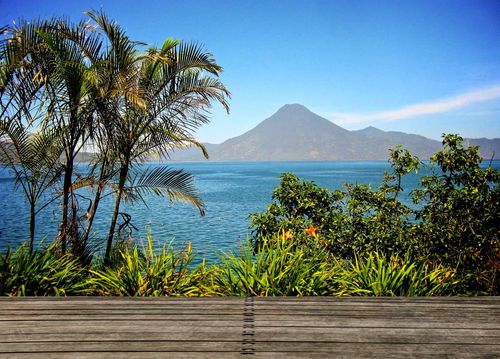
On the highway north to Cobán, just before the village of Purulhá, the Biotopo del Quetzal was established to protect the habitat of the endangered quetzal, Guatemala’s national bird (see The Resplendent Quetzal). The reserve covers a steep area of dense cloudforest, through which the Río Colorado cascades towards the valley floor, forming waterfalls and natural swimming pools.
Two paths through the undergrowth from the road complete a circuit that takes you up into the woods above the reserve headquarters (where maps are available for US$0.75). Quetzals are occasionally seen here but they’re extremely elusive. The best time of year to visit is just before and just after the nesting season (between March & June), and the best time of day is sunrise. In general, the birds tend to spend the nights up in the high forest and float across the road as dawn breaks, to spend the days in the trees below. They can be easily identified by their jerky, undulating flight. A good place to look out for them is at one of their favoured feeding trees, the broad-leaved aguacatillo, which produces a small avocado-like fruit. Whether or not you see a quetzal, the forest itself (usually damp with chipi-chipi, a perpetual mist) is worth a visit: a profusion of lichens, ferns, mosses, bromeliads and orchids spread out beneath a towering canopy of cypress, oak, walnut and pepper trees.
Cubulco
Leaving Rabinal, a paved road heads west, climbing a high ridge with fantastic views to the left into the uninhabited mountain ranges. The road then descends into the next valley to CUBULCO, an isolated town of Achi Maya and ladinos, surrounded on all sides by steep, forested peaks.
Fiesta time in Cubulco
Cubulco is best visited for its annual fiesta. This is one of the few places where you can see the Palo Volador, a pre-conquest ritual in which men throw themselves from a 30m pole with a rope tied around their legs, spinning down towards the ground as the rope unravels, and hopefully landing on their feet. It’s as dangerous as it looks, particularly when you bear in mind that most of the dancers are blind drunk; every few years an inebriated dancer falls from the top of the pole to his death. The fiesta still goes on, though, as riotous as ever, with the main action taking place on July 25. If you’re in town at fiesta time be sure to taste the local chilate drink, made from corn and spices and served in fruit husks.
Rabinal and around
Less than an hour from Salamá via a gap in the hills, RABINAL is a dusty, isolated farming town where the one-storey adobe and cinderblock houses are dominated by a large colonial church. Founded in 1537 by Bartolomé de Las Casas, Rabinal was the first of the settlements he established in his peaceful conversion of the Achi nation. The proportion of indigenous inhabitants is high here and the fine fiesta has a uniquely Achi character.
Market days (Tues & Sun) are fascinating in Rabinal – look for some high-quality local artesanías, including carvings made from the árbol del morro (calabash tree) and traditional pottery.
Rabinal and the civil war
The Rabinal region suffered terribly during Guatemala’s civil war – there were four massacres in 1982 alone. Local people have exhumed several of the mass graves that pepper the hillsides and reburied some of the 4400 victims from the municipality, in an effort to give those killed during la violencia a more dignified resting place. In 2004, the Inter-American Court ordered the Guatemalan government to pay US$8 million as compensation to the surviving families of one massacre. The legal battle continues but the army generals who directed the campaign of terror have hitherto escaped justice, though three PUC (paramilitary conscripts) and four Kaibiles (special forces) were jailed in 2011 for their roles in the massacres. In December 2011 President Colom apologized to relatives of the victims of the 1982 Dos Erres massacre near Rabinal, calling it “a stain on Guatemala’s history”.
Rabinal’s UNESCO fiesta
Rabinal’s fiesta, which runs from January 19 to 24, is renowned for its dances, many of them pre-colonial in origin. The most famous is an extended dance drama known as the Rabinal Achi which re-enacts a battle between the Achi and K’iche’ tribes and is unique to the town, performed annually on January 23 – it’s recently been bestowed UNESCO World Heritage recognition. Others include the patzca, a ceremony to call for good harvests, using masks that portray a swelling below the jaw, and wooden sticks engraved with serpents, birds and human heads.
The Resplendent Quetzal
The quetzal, Guatemala’s national symbol (after which the country’s currency and second city are named), has a distinguished past but an uncertain future. The bird’s feathers have been sacred from the earliest of times, and in the strange cult of Quetzalcoatl, whose influence once spread throughout Mesoamerica, the bird was incorporated into the plumed serpent, a supremely powerful deity. To the Maya the quetzal was so sacred that killing one was a capital offence; the bird is also thought to have been the nahual, or spiritual protector, of the Maya chiefs. When Tecún Umán faced Pedro de Alvarado in hand-to-hand combat, his headdress sprouted the long green feathers of the quetzal, and when the conquistadors founded a city adjacent to the battleground they named it Quetzaltenango, “the place of the quetzals”.
In modern Guatemala the quetzal’s image saturates the country: it features on the national flag, and citizens honoured by the president are awarded the Order of the Quetzal. The bird is also considered a symbol of freedom, since caged quetzals die from the rigours of confinement. Despite all this, deforestation threatens the very existence of the bird, and the Biotopo del Quetzal is about the only serious step that has been taken to save it.
There are six species of the bird, but it’s the male Resplendent Quetzal (found between southern Mexico and Panama) which is the most exotically coloured. Its head is crowned with a plume of brilliant green, and chest and lower belly are a rich crimson; the unmistakeable iridescent green tail feathers (reaching some 60cm in length) are particularly evident in the mating season. The females, on the other hand, are an unremarkable brownish colour. The birds nest in holes found in dead trees, laying one or two eggs, usually in April or May.
Mario Dary
The Biotopo del Quetzal is also known as the Mario Dary Reserve, in honour of an environmental campaigner who spent years campaigning for a cloudforest sanctuary to protect the quetzal, causing great problems for powerful timber companies in the process. He was murdered in 1988. An ecological foundation, Fundary, has been set up in his name to manage protected areas, including Punta de Manabique on the Caribbean coast.
Salamá
Eight kilometres west of San Jerónimo is SALAMÁ, capital of the department of Baja Verapaz. The town has a relaxed and prosperous air, and like many of the places out this way, its population is largely ladino. Sights are slim on the ground, although it’s worth checking out the imposing colonial bridge on the edge of town, and the old church, the gilt of its huge altars darkened by age.
San Jerónimo
At the eastern end of a fertile valley, 18km from the Cumbre junction, lies the small tranquil town of SAN JERÓNIMO. In the Conquest’s early days, Dominican priests built a church and convent here and planted vineyards, eventually producing a wine lauded as the finest in Central America. In 1845, after the religious orders were abolished, an Englishman replaced the vines with sugarcane and began distilling an aguardiente that became equally famous. These days the area still produces sugar, though the cultivation of flowers for export and fish farming are more important.
The church
Presiding over the central plaza, the village’s seventeenth-century Baroque church contains a monumental gilded altar, brought from France, which was crafted from sheets of eighteen-carat gold.
Lanquín and around
Northeast of Cobán, a paved road heads off into the lush hills, connecting a string of coffee fincas. After 46km the road reaches the Pajal junction, where a branch road cuts down deep into a valley to LANQUÍN (a further 12km away). This sleepy, modest Q’eqchi’ village, where Spanish is very much a second language, shelters beneath towering green hills, whose lower slopes are planted with coffee and cardamom bushes. The village itself is very relaxed and quite attractive, but virtually every visitor in town is here to enjoy the extraordinary pools of Semuc Champey, a short ride away.
Market days in the Verapaces
Monday
Senahú; Tucurú.
Tuesday
Chisec; El Chol; Cubulco; Lanquín; Purulhá; Rabinal; San Cristóbal Verapaz; San Jerónimo; Tres Cruces.
Saturday
Senahú.
Sunday
Chisec; Cubulco; Lanquín; Purulhá; Rabinal; Salamá; San Jerónimo; Santa Cruz Verapaz; Tactic.