Chile's Route of Parks: best national parks in Chile

Select Month

plan my trip

Connecting 17 national parks in southern Chile, and stretching from Puerto Montt to Cape Horn, Patagonia’s Route of Parks is a 2800-kilometer scenic trail covering most of the best national parks in Chile. To help you plan your perfect adventure-packed Chile itinerary, read on for an overview of what to expect of Chile's best national parks.

What are the best national parks to visit in Chile?

Created through a visionary public-private conservation effort, Chile’s Route of Parks this route preserves over 11.5 million hectares of pristine wilderness and biodiversity.

One of the most spectacular long-distance nature routes in the world, it takes in many of the best national parks to visit in Chile, including Torres del Paine, Alerce Andino National Park, Melimoyu National Park, Pumalín Douglas Tompkins National Park and Laguna San Rafael.

Whichever of the best national parks in Chile you choose to visit along the Route of Parks, expect a journey that variously covers glaciers, fjords, volcanoes and forests, with opportunities to hike, kayak, watch wildlife and immerse yourself in remote Patagonian communities. 

Planning a road-trip Chile itinerary that covers the Route of Parks? Read our guide to the best road trips in Chile.

Coyhaique and Carretera Austral © sunsinger/Shutterstock

Coyhaique and Carretera Austral © sunsinger/Shutterstock

1. Alerce Andino National Park

Located near Puerto Montt, Alerce Andino National Park in Chile’s Lake District protects a plethora of ancient alerce trees, some of which are over 3000 years old. 

Here, you can look forward to exploring lush temperate rainforests, waterfalls, and serene lakes, which are especially rewarding for birdwatchers and nature enthusiasts.

How to get to Alerce Andino National Park

From Puerto Montt, drive southeast towards Correntoso — the park entrance is well-signposted.

In the early stages of planning your trip to Chile? Take inspiration from the best things to do in Chile, and the best things to do in Patagonia.

2. Hornopirén National Park

Located in northern Patagonia, Hornopirén National Park, is a lush, wild expanse of temperate rainforest, snow-capped volcanoes, glacial lakes, and ancient alerce trees.

The name "Hornopirén" means "Snow Oven" in the Mapuche language, referring to the impressive Hornopirén Volcano that dominates the skyline. 

Offering a tranquil alternative to many of the best national parks in Chile, here you can look forward to hiking through dense forests, marveling at waterfalls, and paddling across mirror-like lagoons, while looking out for pudús (tiny deer), foxes, and a range of native birds. 

How to get to Hornopirén National Park

From Puerto Montt, take a bus, rental car, or ferry south to the town of Hornopirén (around 5–6 hours). The park is a short drive from town. 

Keen to hit Chile's top trekking trails?  Read up on the best hikes in Chile.

argentina-llamas-shutterstock_514122538

Llamas in nature © Shutterstock

3. Pumalín Douglas Tompkins National Park

Pumalín Douglas Tompkins National Park is one of Chile’s most spectacular and ecologically significant protected areas. 

Spanning over 4000 square kilometers of northern Patagonia, it’s a paradise of dense temperate rainforest, snow-capped peaks, thundering waterfalls, deep fjords and ancient alerce trees.

Created through the conservation efforts of the late Douglas Tompkins (co-founder of The North Face), it exemplifies world-class environmental restoration and rewilding, and also offers exceptional hiking trails such as Ventisquero El Amarillo, Laguna Tronador, and Volcán Chaitén.

How to get to Pumalín Douglas Tompkins National Park

Fly or take a bus to Puerto Montt, then continue by ferry or drive the Carretera Austral south to Chaitén, which serves as the gateway town. 

From Chaitén, trailheads and park entrances are accessible by car; a 4x4 is helpful but not essential.

Want more transport context? Read up on getting around Chile.

pumalin-national-park-patagonia-michinmahiuda-volcano-chile-shutterstock_791527339

 Pumalín Douglas Tompkins National Park — one of the best national parks in Chile © Shutterstock

4. Corcovado National Park

Home to the might Corcovado Volcano, Corcovado National Park is one of the most remote and biologically diverse national parks in Chilean Patagonia.

Sprawling over 2,900 square kilometers of rugged terrain, the park encompasses dense temperate rainforests, alpine lakes, fjords and coastal zones, and serves as a vital refuge for endangered species such as Darwin’s frog and the Chilean pudú.

Due to its inaccessibility, Corcovado remains largely untouched by tourism, making it ideal for wilderness expeditions. Note there are no established visitor facilities or formal trails.

How to get to Corcovado National Park

Access is limited and requires planning. The nearest town is Chaitén, reachable via ferry or flight from Puerto Montt. 

From there, you must travel by boat or small aircraft, often through organized guided expeditions, as independent access is logistically complex and restricted.

Not keen on the sound of all that planning? Contact our local Chile travel experts to have them curate your perfect Chile itinerary

View from the Carretera Austral, Puyuhuapi, Patagonia, Chile, South America

Carretera Austral, Puyuhuapi, Patagonia, Chile © Shutterstock

5. Melimoyu National Park

Nestled in Chilean Patagonia along the rugged coastline of the Aysén Region, Melimoyu National Park is a remote and pristine wilderness dominated by the majestic Melimoyu Volcano. 

Protecting a mosaic of glaciers, temperate rainforests, alpine valleys, fjords and rivers, it’s a vital habitat for endangered species like the blue whale, huemul deer and Chilean dolphins. 

Due to its isolation and lack of infrastructure, the park is virtually untouched, offering a rare opportunity for true explorers, researchers, and conservationists seeking solitude and raw nature. 

How to get to Melimoyu National Park

Accessing Melimoyu is challenging and typically involves travel to Puerto Cisnes or Raúl Marín Balmaceda in northern Patagonia. 

From there, boat transport is required to reach the park. As independent access is difficult, it’s best visited as part of a guided expedition.

Vina-del-Mar-chile-shutterstock_1095170075

Chile's waters are rich in marine life © Shutterstock

6. Queulat National Park

Located along Chile’s Carretera Austral in the Aysén Region, Queulat National Park is famed for its ethereal Ventisquero Colgante (Hanging Glacier) — a river of ice that cascades down a mountainside into a misty forest.

The park spans over 1,500 square kilometers of lush Valdivian temperate rainforest, fjords, rivers and waterfalls. 

As such, it serves a mystical landscape, with trails leading through mossy trees to glacier viewpoints and turquoise lagoons.

Meanwhile, boat trips offer up-close views of icebergs and crashing meltwater. The dramatic contrast between forest rock and ice it something else.

How to get to Queulat National Park

From Coyhaique, drive  4–5 hours south along the Carretera Austral to the village of Puyuhuapi.

From there, the main entrance is about 20 minutes away by car. While a 4x4 is helpful in rainy seasons, it’s not essential during the dry months.

magellanic-penguins-magdalena-island-patagonia-chile-shutterstock_232212205

Isla Magdalena, Chile © Shutterstock 

7. Isla Magdalena National Park

Located off the coast of the Aysén Region in Chilean Patagonia, Isla Magdalena National Park is a remote and biodiverse island sanctuary of temperate rainforests, peat bogs, rugged coastlines, and marine ecosystems

As such, it’s a making a haven for endemic flora, seabirds and marine mammals like sea lions, otters and dolphins. 

With no permanent human settlements or infrastructure, Isla Magdalena is a destination for intrepid travelers, scientists and wildlife watchers seeking solitude and immersion in one of Patagonia’s least-explored environments.

How to get to Isla Magdalena National Park

Reach the mainland port town of Puerto Cisnes by road from Coyhaique or by ferry. 

From Puerto Cisnes, arrange boat transport to the island through authorized tour operators.

Cerro Castillo Chile © VGranta/Shutterstock

Cerro Castillo © Shutterstock

8. Cerro Castillo National Park

Cerro Castillo National Park, located in Chile’s Aysén Region, is a striking and less-crowded alternative to Torres del Paine — a place of jagged peaks, glacial lagoons, alpine meadows and rich wildlife. 

Its centerpiece, Cerro Castillo Mountain, resembles a stone fortress with steep, snow-streaked spires rising above turquoise lakes like Laguna Cerro Castillo. 

The park is a haven for serious trekkers, with the multi-day Cerro Castillo Circuit (3–4 days) providing a challenging but rewarding experience with minimal crowds. 

Meanwhile, shorter hikes, such as the route to the laguna viewpoint, offer equally breath-taking views. 

How to get to Cerro Castillo National Park 

Fly into Balmaceda Airport then drive or take a bus about 1.5 hours south along the Carretera Austral to the village of Villa Cerro Castillo. 

From there, park access is nearby, with ranger stations and guided services available.

Ahead of planning how to get to some of the best national parks in Chile, wise up on getting to Chile.

9. Patagonia National Park

Patagonia National Park is one of the crown jewels of the Route of Parks — a vast landscape of windswept steppe, glacial rivers, snow-capped peaks, and remarkable biodiversity. 

The park’s extensive trail network includes scenic day hikes like the Laguna Altas Trail and more rugged multi-day options. 

With few crowds and an emphasis on conservation and sustainability, it’s a haven for hikers, birdwatchers, and nature photographers seeking Patagonia in its purest form.

How to get to Patagonia National Park

Fly into Balmaceda Airport near Coyhaique, then drive 6–7 hours south on the Carretera Australto Cochrane or the Valle Chacabuco entrance. 


san-rafael-glacier-shutterstock_37767340

San Rafael © Shutterstock

10. Laguna San Rafael National Park

Laguna San Rafael National Park is a remote wilderness that’s best known for the massive San Rafael Glacier — one of the few glaciers in the world that descends right to the sea. 

Part of the Northern Patagonian Ice Field, the park covers over 17,000 square kilometers of fjords, rainforests, ice fields and marine ecosystems. 

Visitors come here witness ice calving dramatically into the lagoon, explore icy fjords by boat, and to hike through lush forests teeming with wildlife. 

How to get to Laguna San Rafael National Park

Most visitors depart from Puerto Chacabuco or Puerto Montt via organized catamaran tours or expedition cruises.

Charter flights also reach the glacier via nearby Campo de Hielo Norte.

Lake Fagnano ©  Pola Damonte/Shutterstock

Lake Fagnano © Pola Damonte/Shutterstock

11. Bernardo O’Higgins National Park

Encompassing a landscape of fjords, glaciers, mountains, and subpolar forests — much of it still unexplored and inaccessible — Bernardo O’Higgins National Park is Chile’s largest protected area.

Spanning over 3.5 million hectares across southern Patagonia, it contains some of the country’s most massive and active glaciers, including Pío XI, the largest in the Southern Hemisphere outside Antarctica. 

How to get to Bernardo O’Higgins National Park

The most common access point is via boat from Puerto Natales, often as part of cruise expeditions or guided kayaking tours.

12. Pali Aike National Park

Located in Chile’s far southern Magallanes Region near the border with Argentina, Pali Aike National Park offers a stark, mesmerizing landscape that’s been shaped by ancient volcanic activity. 

Here, landscapes of eerie lava fields, rugged craters, caves, and windswept steppes certainly live up to its name, which means “Desolate Place” in the Aónikenk (Tehuelche) language.

Among the main attractions are the Pali Aike Crater, Laguna Ana (a flamingo habitat), and the Cueva de Pali Aike, where prehistoric human remains have been found. 

How to get to Pali Aike National Park

From Punta Arenas, drive approximately 2 hours northeast along Ruta 255 toward the Argentine border. 

The park is well-signposted and accessible by gravel road.

Punta Arenas, Chile

Punta Arenas, Chile © Shutterstock

13. Kawésqar National Park

Kawésqar National Park, located in Chile’s southern Patagonia, is one of the largest protected areas in the country, covering over 2.8 million hectares of fjords, islands, channels, temperate rainforest and towering mountain ranges. 

Named after the indigenous Kawésqar people who once navigated these waters in canoes, the park remains wild and largely unexplored.

With virtually no infrastructure, it is a place of raw natural beauty — think deep fjords, dramati and coastlines.

How to get to Kawésqar National Park

The park is best accessed via boat from Puerto Natales or Punta Arenas through a multi-day expedition or adventure cruise. 

Independent access is extremely limited and typically requires a guide or organized tour, especially for exploring inner fjords.

14. Alberto de Agostini National Park

Located in Chile’s extreme south within the Tierra del Fuego archipelago, Alberto de Agostini National Park is a dramatic landscape of glaciers, fjords, jagged peaks, and dense Magellanic forests. 

Named after Italian missionary and explorer Alberto Maria de Agostini, it’s part of the UNESCO Cape Horn Biosphere Reserve and one of the world’s last untouched wildernesses — perfect for adventurous travelers and wildlife photographers seeking off-grid exploration.

It’s also part of the Cordillera Darwin range and includes the stunning Marinelli Glacier and Mount Sarmiento, one of Patagonia’s most iconic peaks. 

How to get to Alberto de Agostini National Park

Access is only by boat or cruise ship. Departures typically originate from Punta Arenas via expedition cruises, which explore the park’s fjords and glacier fronts over several days.

Tierra del Fuego, Patagonia, Argentina

Tierra del Fuego, Chile © Shutterstock

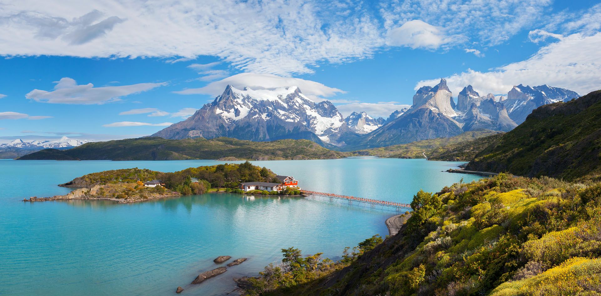
15. Torres del Paine National Park

Torres del Paine National Park is one of the most spectacular national parks in South America. Its centerpiece is a trio of granite peaks — the Torres (Towers) del Paine.

 The park is renowned for its world-class trekking routes, including the W Trek (4–5 days) and the more challenging O Circuit (7–9 days), which pass through awe-inspiring landscapes of glaciers, valleys, rivers and wildlife — visitors regularly spot guanacos, condors, foxes, and sometimes pumas. 

With excellent infrastructure, scenic lodges, and well-marked trails, Torres del Paine balances remote beauty with accessibility.

How to get to Torres del Paine National Park

Fly to Punta Arenas from Santiago, then drive or take a bus to Puerto Natales (3 hours). 

From Puerto Natales, the park is about 1.5–2 hours by car or shuttle. Regular buses run during high season (October to April).

House on the island in the national park Torres del Paine, lake Pehoe, Patagonia, Chile © Shutterstock

Torres del Paine, Chile © Shutterstock

16. Yendegaia National Park

Located on the southern coast of Chile’s Tierra del Fuego, Yendegaia National Park is one of the most remote and least explored parks in the Route of Parks. 

Covering over 150,000 hectares, it protects a breath-taking landscape of sub-Antarctic forests, glacier-fed rivers, alpine lakes, peat bogs, and jagged mountain peaks — including the easternmost stretch of the Darwin Range. 

Once used for cattle ranching, the area has been rewilded into a haven for wildlife, including condors, foxes, and guanacos.

With few established trails and almost no infrastructure, the park offers a raw, frontier experience for backcountry adventurers and conservationists.

How to get to Yendegaia National Park

The main access is from Puerto Williams on Navarino Island, reachable by flight from Punta Arenas or by ferry via Puerto Natales. 

From Puerto Williams, organized boat transfers and trekking expeditions can access Yendegaia.

Tierra del Fuego, Patagonia, Argentina

Tierra del Fuego © Shutterstock

17. Cabo de Hornos National Park

Located on Hornos Island at the southernmost tip of Chile, Cabo de Hornos National Park is part of the UNESCO-designated Cape Horn Biosphere Reserve.

Renowned for its rugged cliffs, fierce winds, and dramatic ocean and named after the legendary Cape Horn, it’s long been a maritime milestone — once dreaded by sailors for its treacherous seas. 

Despite its inhospitable conditions, the park shelters a surprisingly rich ecosystem of mosses, lichens, seabirds and marine life.

The famous Cape Horn Monument and lighthouse operated by the Chilean Navy are key points of interest, along with interpretive trails and windswept viewpoints.

How to get to Cabo de Hornos National Park

Access is only by boat, typically via expedition cruise from Puerto Williams or Punta Arenas, or on guided tours that include a zodiac landing on Hornos Island.


Inspired to visit Chile? While planning your trip, wise up with our Chile travel advice, find out about Chile accommodation, and take inspiration from our Chile itineraries, including a 10 days in Chile itinerary, and a 14 days in Chile itinerary.

Not a fan of planning? Contact our local Chile travel experts.

Joanne Owen

written by
Joanne Owen

updated 09.06.2025

Joanne is a Pembrokeshire-born writer with a passion for the nature, cultures and histories of the Caribbean region, especially Dominica. Also passionate about inspiring a love of adventure in young people, she’s the author of several books for children and young adults, hosts international writing workshops, and has written articles on the Caribbean and inspirational community initiatives for Rough Guides. Follow her @JoanneOwen on Twitter and @joanneowenwrites on Instagram.

  • Nature & Wildlife
  • National Parks & Reserves
  • Off the Beaten Track
  • Walking Hiking Trekking
  • Inspiration
  • Chile

Planning your own trip? Prepare for your trip

Use Rough Guides' trusted partners for great rates