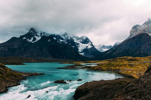
South of Lago General Carrera
South of the great lake, a gravel road winds its way along the river towards Cochrane, the last settlement of any size and the gateway to the Reserva Nacional Tamango. Beyond Cochrane, the road snakes its way through a dense carpet of evergreens and giant nalca. After just over 100km south, you come to the embarcadero de Río Vagabundo, the launching spot for boats to the tiny, remote hamlet of Caleta Tortel, also reachable by the gravel road that forks west from the Carretera. Further south, at Puerto Yungay, a car ferry crosses Fiordo Mitchell and a precarious road leads to the Carretera’s final stop – tiny Villa O’Higgins.
Cochrane
The last major stop on the Carretera Austral, the ranching settlement of Cochrane lies 50km south of Puerto Bertrand. The town’s paved, orderly grid of streets spreading out from the neat Plaza de Armas, and array of limited services, make this a prime spot to rest up after the wildness of the Carretera Austral.
Caleta Tortel
Visitors fall in love with Tortel as soon as they see this scattering of houses on forested slopes surrounding a pale emerald bay. Located at the mouth of the Río Baker between the northern and southern ice fields and a logging spot for a lumber company, Tortel soon grew into a scattered settlement of quaint wooden houses, each with its own jetty and linked by a network of walkways and bridges made of fragrant cypress (slippery when wet). There are no streets here, and even the fire engine is a boat. Tortel is in some ways more isolated than the rest of the settlements along the Carretera Austral; there is only one direct phone line to the municipality, with extensions to everywhere else, though landlines are coming soon.
Within easy reach of Tortel by boat are two glaciers: Ventisquero Steffens, which originates in the northern ice field (3hr north by boat), and Ventisquero Jorge Montt, an enormous bluish ice-wall that comes from the southern ice field (5hr by lancha; 2hr by motorboat), best done in a group, as the trip is charged per vessel.
Villa O’Higgins
Tiny Villa O’Higgins was built on a simple grid, with the Carretera Austral running along the western side all the way down to the Bahía Bahamondez on the enormous glacial Lago O’Higgins, 7km away.
Most of the earliest settlers – who came at the beginning of the twentieth century, when it was most easily accessible from Argentina – were British. The first Chilean settlers did not arrive until the 1920s, and the town wasn’t officially founded and given its present name until 1966. Until 1999, this cluster of wooden houses huddled against a sheer mountain face was reachable only by a small prop plane from Coyhaique or by boat from Argentina but is now on the verge of being connected to Argentina’s Ruta 40, which will make travel between the two countries considerably easier if you have your own vehicle. Cosmopolitan Villa O’Higgins is not, but it is a triumphant finishing point for cyclists “doing” the Carretera Austral, as well as a springboard for reaching some of the area’s more remote glaciers.
Argentina the hard way: the El Chaltén crossing
The crossing between Villa O’Higgins and Argentina’s El Chaltén is still remote and challenging, yet more and more hardy travellers are prepared to take the boat, followed by a strenuous hike over the border and then another lake crossing. The sixty-passenger Quetru, connected to Villa O’Higgins by a private minibus run by the owner of El Mosco, leaves Bahía Bahamóndez at 8.30am and arrives at the hamlet of Candelario Mancilla at around 11am. Just beyond the dock a signposted dirt track leads uphill from the main dirt road to the only accommodation option – a campsite with no facilities apart from drinking water obtained from a stream and two or three basic rooms available in the owner’s house. Get your passport stamped by Chilean border control further up the main road before you set off for Argentina.
To the border
Beyond, a gravel road winds uphill through patches of woodland to the international border; on the way, you will have to ford the shallow, glacial Río Obstáculo. Beyond the border, marked by signs welcoming you into Chile and Argentina, the 7.5km stretch of trail to the Argentine Gendarmería on the banks of the Lago del Desierto becomes a narrow, muddy footpath snaking its way through hilly forest and scrubland; cyclists have to push and sometimes carry their bikes. After getting stamped into Argentina, you can either pitch a tent at Camping Lago del Desierto, stay in the basic cabaña run by the gendarmes, catch the motor launch Viedma across the lake or hike the remaining 15km along a steep, thickly forested path on the left side of the lake, emerging at the guardería by the pier on the south side.
Minibuses to El Chaltén meet the arriving motor launches. While it is possible to complete the border crossing in a day, particularly if coming the other way from El Chaltén to Villa O’Higgins (since the last part of the hike is all downhill), boat schedules are weather-dependent, so you must pack enough food for several days. To book a guide and packhorses, visit villaohiggins.com. Rumours abound that there are plans to build a road on the Argentinian side to connect it to the border, perhaps as early as 2013, so the time to do the crossing is now.
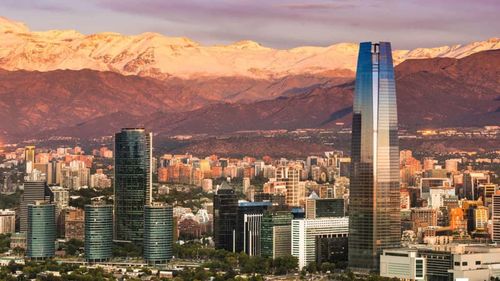
Southern Patagonia
Patagonia lies tucked away right at the southernmost tip of the Americas – indeed of the world’s landmass, not counting Antarctica. While the very name holds a fascination for many travellers, the reality can be harsh: the place is cursed by a persistent wind, the Escoba de Dios (God’s Broom); trees grow horizontally here, sculpted by the gales; winters are long and summers short. Geographically ill-defined, “Patagonia” usually refers to the narrow triangle of land south of a line between Puerto Montt, in Chile, and Argentina’s Península Valdés, while in Chile the term is usually reserved for Southern Patagonia, where the Andes take a last, dramatic breath before plunging into the ocean.
What to see in Southern Patagonia
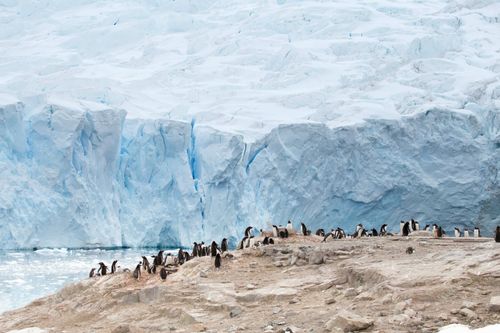
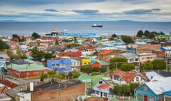
While much of Argentine Patagonia is flat rolling pampa, the land rises in the western sliver of land shared by both countries; it is said that people on both sides of the border think of themselves as Patagonians first, and Chileans or Argentinians second, united by a common ranching culture that has long been in decline. These days, large numbers of Chileans and non-Chilean visitors alike come to Patagonia not to farm but to hike – in the country’s most famous and stunning national park, Parque Nacional Torres del Paine, a massif crowned with otherworldly granite towers, and accessed from the superbly located gateway town of Puerto Natales. Others come to follow in the footsteps of the region’s famous travellers: navigator Ferdinand Magellan, naturalist Charles Darwin and author Bruce Chatwin; to gaze at the region’s many spectacular glaciers; or to visit the penguin colonies from the lively provincial capital of Punta Arenas – a port city sitting on the shore of the stormy Magellan Strait.
Since the whole of this region is physically cut off from the rest of Chile by two vast ice caps, the only links with territory to the north are by air, water or through Argentina. The last option allows you to visit traditional estancias and some of Argentina’s finest landscapes, including the Parque Nacional Los Glaciares, where the Fitz Roy Massif, near the tiny town of El Chaltén, offers incredible hiking and climbing opportunities, while Glaciar Perito Moreno, accessible from the tourist hub of El Calafate, is visually arresting, not to mention the most accessible of all South American glaciers.
Brief history of Southern Patagonia
Chilean Patagonia, the site of the some of the continent’s oldest human habitation, was originally populated by Tehuelche hunter-gatherers, who stalked roaming guanacos in the interior, and the sea-faring Kawéscar who dove naked for shellfish in the frigid waters around the southern fjords. The first European to discover the area was Ferdinand Magellan, a Portuguese navigator who sailed through the strait now bearing his name. Spanish colonization attempts failed catastrophically and no European tried to settle the place again for another two hundred and fifty years.
The voyages of the Beagle, from 1826 to 1834, the second one bearing young Charles Darwin, renewed interest in the area, prompting continued Chilean and Argentine attempts to colonize the area. In the 1870s the two narrowly avoided war over the territory, not for the last time. From 1849, Punta Arenas was boosted by sea traffic en-route to the California Gold Rush; while it didn’t last long, the introduction of sheep farming created sprawling estancias (ranches) and brought great wealth to their owners in the late nineteenth century.
Wool has now been replaced by oil, commercial salmon farming and tourism as the region’s main resources. The Chileans call the area the province of Magallanes, in the explorer’s honour; it has its own flag and is one of the least inhabited areas in Chile.
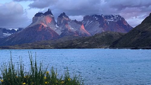
Parque Nacional Torres del Paine
Nothing really prepares you for your first sight of Parque Nacional Torres del Paine. The Paine Massif, the unforgettable centrepiece of the park, appears beyond the turquoise lakes long before you get close to it. The finest views of the massif are from the south bank of Lago Nordenskjöld, whose waters act as a great reflecting mirror. If driving through the park, take the southern entrance to constantly have the best views in front of you.
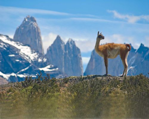
The centrepiece is made up of the twin peaks of Cerro Monte Almirante Nieto (2668m and 2640m). On the northern side are the soaring, unnaturally elegant Torres del Paine (“Paine Towers”), the icon of the park, and further west the sculpted, dark-capped Cuernos del Paine (“Paine Horns”). To the west of the park is the broad ice river of Glaciar Grey, and on the plains at the mountains’ feet, large herds of guanacos and the odd ñandú (rhea) still run wild; you’re more likely to spot these than the park’s more elusive fauna: pumas and the rare huermúl deer.
In January and February the park is crammed with holidaymakers, so the best months to visit are October, November and December or March and April. Although in winter (June–Sept) temperatures can fall to -10°C (14°F) or even lower, freezing lakes and icing over trails, the small numbers of visitors, lack of wind and often clear visibility can also make this another good time to come – just wrap up warmly.
Hiking routes in Parque Nacional Torres del Paine
This may not be the place to taste true wilderness, but there are still plenty of places to lose the crowds. The two most popular hikes are the “W”, so-called because the route you follow looks like a “W”, up three valleys, taking you to the “stars” of the park – Las Torres, Valle del Francés and Glaciar Grey, and the “Circuit”, which leads you around the back of the park and encompasses the “W”; allow seven to ten days for the “Circuit” and at least four for the “W”.
The best way to tackle the “Circuit” is anticlockwise, as it also means you’ll have excellent views of Glacier Grey in front of you rather than behind you when you come to tackle the most challenging part of the hike – the Paso John Gardner.
It’s also best to do the “W” anti-clockwise, leaving the steepest hike to Las Torres until last, by which time you will have consumed most of your supplies. The first leg of the “W” is the hike there and back from Paine Grande Lodge to Glaciar Grey, described above. You can leave your gear at the lodge.
Beyond the W: Torres del Paine alternative hikes
There is more to Torres del Paine than just the “Circuit” and the “W”; numerous shorter hikes can be just as spectacular.
Mirador Lago Grey and Mirador Ferrier
From the Lago Grey ranger station near Hotel Lago Grey, a short trail leads through the forest to the lake’s vast windswept beach, where you can watch house-sized chunks of bluish ice bobbling on the pale waters. To the left of the beach, by the jetty, a fairly steep unmarked trail skirts around the cliff before giving you an unobstructed view of Glaciar Gray. The most spectacular viewpoint of them all, Mirador Ferrier, lies a stiff two-hour hike up from behind the ranger station. From up there, you get a jaw-dropping vista over the park’s many lakes, their colours ranging from aquamarine to greyish white. At the top, you make your way through forest before emerging among exposed rocks; bring warm clothes as the icy wind can be ferocious.
Laguna Azul
There’s a three-and-a-half-hour signposted walk from the guardería at Laguna Amarga to Laguna Azul, a secluded and little-visited lake in the northeast. From there, a mostly gentle four-hour trail leads past Laguna Cebolla to Lago Paine. It used to be possible to hike to Lago Dickson and cross the narrowest part of the lake to Refugio Dickson, but the boat is no longer functioning, though if you are on horseback, you can wade across Río Paine and continue along this trail to a viewpoint overlooking Glaciar Dickson.
Mirador Zapata
Another seldom-trod path takes you up to Mirador Zapata, a steep six-to seven-hour climb from Guardería Lago Grey at the southern tip of Lago Grey, itself a four-and-a-half-hour walk from the park administration building, rewarding you with views of the ice cap and the magnificent Glaciar Pingo. Campamento Pingo is half an hour into the trek, and Campamento Zapata an hour and a half from the mirador, making it an ideal overnight stop.
The Balmaceda and Serrano glaciers
To the northwest of the Cueva del Milodón, the Seno Ultima Esperanza continues on for about 100km until it meets the Río Serrano, which, after 36km, arrives at the Balmaceda and Serrano glaciers. A boat trip here is one of the most beautiful in the entire area. It takes seven hours and you pass a colony of cormorants and a slippery mass of sea lions. The glaciers themselves make an impressive sight, especially when a chunk of ice the size of a small house breaks off and crashes into the water. They form the southern tip of Parque Nacional Bernardo O’Higgins, the largest and least-visited national park in the whole of Chile. The east of the park is almost entirely made up of the Campo de Hielo Sur (the Southern Ice Field); the west comprises fjords, islands and untouched forest.
Parque Nacional Los Glaciares
The vast majority of travellers to Patagonia don’t limit themselves to the Chilean side alone. Just over the easily crossed border lies Argentina’s most spectacular national park – Parque Nacional Los Glaciares – home to two of the region’s star attractions. The first is the craggy blue face of the Glaciar Perito Moreno – regularly cited as one of the world’s natural wonders, and situated near the tourist hub of El Calafate. The second is the trekkers’ and climbers’ paradise of the Fitz Roy mountain range in the north of the park, accessed from the relaxed little town of El Chaltén.
El Calafate
Settled by wool traders in the 1920s and named after the edible purple berry that pops up on thorny bushes in summertime, El Calafate expanded rapidly following the creation of Parque Nacional Los Glaciares in 1937. The Perito Moreno glacier is the main draw for the many visitors who flood the town, which is busiest between December and March. The glacier aside, El Calafate makes an excellent base for other park-related activities: boat trips, ice trekking, visits to nearby estancias and hikes into the remotest corners of this slice of wilderness. The main drag, Avenida Libertador, is lined with tourism outfits and restaurants.
Fitz Roy Massif
The northernmost section of Argentina’s Parque Nacional Los Glaciares contains the Fitz Roy Massif, boasting some of the most breathtakingly beautiful mountain peaks on the planet. Two concentric jaws of jagged teeth puncture the Patagonian sky, with the 3445m incisor of Monte Fitz Roy at the centre.
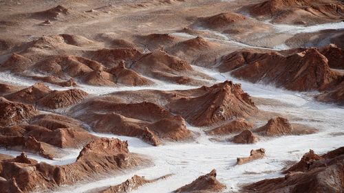
Top image © Shutterstock