East Coast of the Highlands of Scotland
The east coast of the Highlands, between Inverness and Wick, is nowhere near as spectacular as the west, with gently undulating moors, grassland and low cliffs where you might otherwise expect to find sea lochs and mountains. While many visitors speed up the main A9 road through this region in a headlong rush to the Orkneys’ prehistoric sites, those who choose to dally will find a wealth of brochs, cairns and standing stones, many in remarkable condition.
The area around the Black Isle and the Tain was a Pictish heartland, and has yielded many important finds. Further north, from around the ninth century AD onwards the Norse influence was more keenly felt than in any other part of mainland Britain, and dozens of Scandinavian-sounding names recall the era when this was a Viking kingdom.
The fishing heritage is a recurring theme along this coast, though there are only a handful of working boats scattered around the harbours today; the area remains one of the country’s poorest, reliant on relatively thin pickings from sheep farming, fishing and tourism. The one stretch of the east coast that’s always been relatively rich, however, is the Black Isle just over the Kessock Bridge heading north out of Inverness, whose main village, Cromarty, is the region’s undisputed highlight.
Beyond the golfing resort of Dornoch, the ersatz-Loire chateau Dunrobin Castle is the main tourist attraction, a monument as much to the iniquities of the Clearances as to the eccentricities of Victorian taste. Wick, the largest town in these parts, has an interesting past entwined with the fishing industry, but is otherwise uninspiring.
The Black Isle
Sandwiched between the Cromarty Firth to the north and the Moray and Beauly firths to the south, which separate it from Inverness, the Black Isle is not an island at all but a fertile peninsula. Its rolling hills, prosperous farms and stands of deciduous woodland make it feel more reminiscent of Dorset or Sussex than the Highlands. For 8-day Scotland trips based around Inverness or the northeast, the Black Isle offers an easy change of pace, with gentle countryside, coastal views and one of the region’s best wildlife stops.
It probably gained its name from its mild climate: there is rarely frost, leaving the fields “black” all winter. Another explanation is that the name derives from the Gaelic word for black, dubh, possibly through a corruption of St Duthus. On the south side of the Black Isle, near Fortrose, Chanonry Point juts into a narrow channel in the Moray Firth and is an excellent place to look for dolphins.
Cromarty on the Black Isle
An ancient legend recalls that the twin headlands flanking the entrance to the Cromarty Firth, known as The Sutors (from the Gaelic word for shoemaker), were once a pair of giant cobblers who used to protect the Black Isle from pirates. Nowadays, however, the only giants in the area are the colossal oil rigs marooned in the estuary off Nigg and Invergordon like metal monsters marching out to sea. They form a surreal counterpoint to the web of tiny streets and charming workers’ cottages of Cromarty. The Black Isle’s main settlement, Cromarty was an ancient ferry-crossing point on the pilgrimage trail to St Duthus’s shrine in Tain, but lost much of its trade during the nineteenth century to places served by the railway; a branch line to the town was begun but never completed. Cromarty became a prominent port in 1772 when an entrepreneurial local landlord, George Ross, founded a hemp mill here, fuelling a period of prosperity during which Cromarty acquired some of Scotland’s finest Georgian houses: these, together with the terraced fishers’ cottages of the nineteenth-century herring boom, have left the town with a wonderfully well-preserved concentration of Scottish domestic architecture.
The museum, housed in the old Courthouse on Church Street, tells the history of the town using audiovisuals and animated figures. Dolphin- and other wildlife-spotting trips are offered locally by EcoVentures, who travel out through the Sutors to the Moray Firth in a powerful RIB.
The Dornoch Firth and around
North of the Cromarty Firth, the hammer-shaped Fearn peninsula can still be approached from the south by the ancient ferry crossing from Cromarty to Nigg, though to the north the link is a causeway over the Dornoch Firth, the inlet that marks the northern boundary of the peninsula. On the southern edge of the Dornoch Firth the A9 bypasses the quiet town of TAIN, an attractive, old-fashioned small town of grand whisky-coloured sandstone buildings that was the birthplace of St Duthus, an eleventh-century missionary who inspired great devotion in the Middle Ages. Tain’s main attraction is the Glenmorangie whisky distillery where the highly rated malt is produced; it lies beside the A9 on the north side of town. Booking is recommended for the tours; there is also a shop.
Dornoch
Dornich, a genteel and appealing town eight miles north of Tain, lies on a flattish headland overlooking the Dornoch Firth. A middle-class holiday resort, with trees and flowers in profusion, solid Edwardian hotels, and miles of sandy beaches giving good views across the estuary to the Fearn peninsula, the town is renowned for its championship golf course, Scotland’s most northerly first-class course. Nearby Skibo Castle was where Madonna married Guy Ritchie; she also had her son baptized in Dornoch cathedral.
Golspie
Ten miles north of Dornoch on the A9 lies the straggling red sandstone town of Golspie, whose status as an administrative centre does little to relieve its dullness. It is, however, the jumping-off point for some brilliant mountain biking: the fabulous Highland Wildcat Trails are within the forested hills just half a mile to the west. The easy to severe (colour-coded) trails include a huge descent from the summit of Ben Bhraggie to sea level and a ride past the Sutherland monument, erected in memory of the landowner who oversaw the eviction of thousands of his tenants in a process known as the Clearances.
Sutherland Monument
Immediately behind Golspie, you can’t miss the 100ft monument to the first Duke of Sutherland, which peers proprietorially down from the summit of the 1293ft Beinn a’Bhragaidh (Ben Bhraggie). An inscription cut into its base recalls that the statue was erected in 1834 by “a mourning and grateful tenantry [to] a judicious, kind and liberal landlord [who would] open his hands to the distress of the widow, the sick and the traveller”. Unsurprisingly, there’s no reference to the fact that the duke, widely regarded as Scotland’s own Josef Stalin, forcibly evicted 15,000 crofters from his million-acre estate. It’s worth the stiff climb to the top of the hill (round trip 1hr 30min) for the wonderful views south along the coast past Dornoch to the Moray Firth and west towards Lairg and Loch Shin. The path is steep and strenuous in places, however, and there’s no view until you’re out of the trees, about twenty minutes from the top.
Wick
Originally a Viking settlement named Vik (meaning “bay”), WICK has been a royal burgh since 1589. It’s actually two towns: Wick proper, and Pultneytown, south across the river, a messy, rather run-down community planned by Thomas Telford in 1806 to encourage evicted crofters to take up fishing. Wick’s heyday was in the mid-nineteenth century, when it was the busiest herring port in Europe, with a fleet of more than 1100 boats exporting tons of fish to Russia, Scandinavia and the West Indian slave plantations. Though redevelopment of the harbour is underway, the town still has a down-at-heel air. The area around the harbour in Pultneytown, lined with rows of fishermen’s cottages, is most worth a wander, with acres of largely derelict net-mending sheds, stores and cooperages around the harbour giving some idea of the former scale of the fishing trade. The town’s story is told in the Wick Heritage Centre in Bank Row, Pultneytown. The only other visitor attraction is the fairly simple Pulteney Distillery on nearby Huddart Street, a few blocks from the sea.
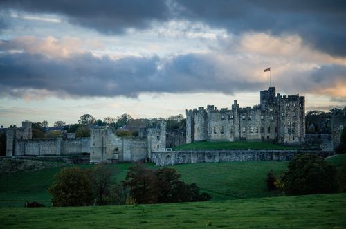
Carbisdale Castle
Towering high above the River Shin, twenty miles northwest of Tain, the daunting neo-Gothic profile of Carbisdale Castle overlooks the Kyle of Sutherland, as well as the battlefield where the gallant Marquess of Montrose was defeated in 1650, finally forcing Charles II to accede to the Scots’ demand for Presbyterianism. The castle was erected between 1906 and 1917 for the dowager Duchess of Sutherland, following a protracted family feud. Designed in three distinct styles (to give the impression that it was added to over a long period of time), Carbisdale was eventually acquired by a Norwegian shipping magnate in 1933, and finally gifted, along with its entire contents and estate, to Hostelling Scotland, which turned it into one of the most opulent hostels in the world. Bring a bike to take advantage of the several miles of mountain-biking trails in the nearby Balblair and Carbisdale woods. The best way to get here by public transport is to take a train from Inverness to nearby Culrain station.
North Coast of the Highlands of Scotland
Though a constant stream of sponsored walkers, caravans and tour groups makes it to the dull town of John O’Groats, surprisingly few visitors travel the whole length of the Highlands’ wild north coast. Those that do, however, rarely return disappointed. Pounded by one of the world’s most ferocious seaways, Scotland’s rugged northern shore is backed by barren mountains in the west, and in the east by lochs and open rolling grasslands. Between its far ends, miles of crumbling cliffs and sheer rocky headlands shelter bays whose perfect white beaches are nearly always deserted, even in the height of summer – though, somewhat incongruously, they’re also home to Scotland’s best surfing waves.
Durness is a good jumping-off point for nearby Balnakiel beach, one of the area’s most beautiful sandy strands, and for rugged Cape Wrath, the windswept promontory at Scotland’s northwest tip. Thurso, the largest town on the north coast, is really only visited by those en route to Orkney. More enticing are the huge seabird colonies clustered in clefts and on remote stacks at Dunnet Head and Duncansby Head, to the east of Thurso.
John O’Groats and around
Romantics expecting to find a magical meeting of land and water at JOHN O’GROATS are invariably disenchanted – sadly it remains an uninspiring tourist trap. The views north to Orkney are fine enough, but the village offers little more than a string of souvenir shops and cafés thronged with coach parties. A number of boat trips set off from here, with some operators offering whitewater rafting and others heading out to Duncansby head and local seal colonies. The village gets its name from the Dutchman Jan de Groot, who obtained the ferry contract for the hazardous crossing to Orkney in 1496. The eight-sided house he built for his eight quarrelling sons (so that each one could enter by his own door) is echoed in the octagonal tower of the much-photographed but now vacant John O’Groats Hotel.
Durness and around
Scattered around a string of sheltered sandy coves and grassy cliff-tops, Durness is the most northwesterly village on the British mainland. It straddles the turning point on the main A838 road as it swings east from the inland peat bogs of the interior to the north coast’s fertile strip of limestone machair. Durness village sits above its own sandy bay, Sango Sands, while half a mile to the east is SMOO, formerly a RAF station. In between Durness and Smoo is the village hall, whose windblown and rather forlorn community garden harbours a memorial commemorating the Beatle John Lennon, who used to come to Durness on family holidays as a child (and revisited the place in the 1960s with Yoko). It’s worth pausing at Smoo to see the 200ft-long Smoo Cave, a gaping hole in a sheer limestone cliff formed partly by the action of the sea and partly by the small burn that flows through it.
Cape Wrath
An excellent day-trip begins two miles southwest of Durness at KEOLDALE, where (tides and MOD permitting) a foot-passenger ferry crosses the spectacular Kyle of Durness estuary to link with a minibus that runs the eleven miles out to Cape Wrath, mainland Britain’s most northwesterly point. Note that Garvie Island (An Garbh-eilean) is an air bombing range, and the military regularly close the road to Cape Wrath. The headland takes its name not from the stormy seas that crash against it for most of the year, but from the Norse word hvarf, meaning “turning place” – a throwback to the days when Viking warships used it as a navigation point during raids on the Scottish coast.
Thurso
Approached from the isolation of the west, THURSO feels like a metropolis. In reality, it’s a relatively small service centre visited mostly by people passing through to the adjoining port of Scrabster to catch the ferry to Orkney, or by increasing numbers of surfers attracted to the waves on the north coast. There’s little to see, but the grid-plan streets have some rather handsome Victorian architecture in the local, greyish sandstone. If you’re coming to surf, want a lesson, need to hire a board or simply fancy a coffee and home-made cake before hitting the waves, head for Tempest Surf on Riverside Road by Thurso harbour.
The West Coast of the Highlands of Scotland
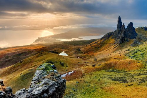
The Highlands’ starkly beautiful west coast – stretching from the Morvern peninsula (opposite Mull) in the south to wind-lashed Cape Wrath in the far north – is arguably the finest part of Scotland. Serrated by fjord-like sea lochs, the long coastline is scattered with windswept white-sand beaches, cliff-girt headlands, and rugged mountains sweeping up from the shoreline. When the sun shines, the sparkle of the sea, the richness of colour and the clarity of the views out to the scattered Hebrides are simply irresistible. This is the least populated part of Britain, with just two small towns, and yawning tracts of moorland and desolate peat bog between crofting settlements.
Lying within easy reach of Inverness, the popular stretch of the coast between Kyle of Lochalsh and Ullapool features the region’s more obvious highlights: the awesome mountainscape of Torridon, Gairloch’s sandy beaches, the famous botanic gardens at Inverewe, and Ullapool itself, a picturesque and bustling fishing town from where ferries leave for the Outer Hebrides. However, press on further north, or south, and you’ll get a truer sense of the isolation that makes the west coast so special. Traversed by few roads, the remote northwest corner of Scotland is wild and bleak, receiving the full force of the North Atlantic’s frequently ferocious weather. The scattered settlements of the far southwest, meanwhile, tend to be more sheltered, but they are separated by some of the most extensive wilderness areas in Britain – lonely peninsulas with evocative Gaelic names like Ardnamurchan, Knoydart and Glenelg.
Kyle of Lochalsh and around
As the main gateway to Skye, KYLE OF LOCHALSH used to be an important transit point for tourists, locals and services. However, with the building of the Skye Bridge in 1995, Kyle was left as merely the terminus for the train route from Inverness, with little else to offer. Of more interest is nearby Eilean Donan Castle, perched at the end of a stone causeway on the shores of Loch Duich. A few miles north of Kyle of Lochalsh is the delightful village of Plockton, a refreshing alternative to its utilitarian neighbour, with cottages grouped around a yacht-filled bay and Highland cattle wandering the streets.
The “Rough Bounds”
The remote and sparsely populated southwest corner of the Highlands, from the empty district of Morvern to the isolated peninsula of Knoydart, is a dramatic, lonely region of mountain and moorland fringed by a rocky, indented coast whose stunning white beaches enjoy wonderful views to Mull, Skye and other islands. Its Gaelic name, Garbh-chiochan, translates as the “Rough Bounds”, implying a region geographically and spiritually apart. Even if you have a car, you should spend some time here exploring on foot; there are so few roads that some determined hiking is almost inevitable.
The Ardnamurchan peninsula
A nine-mile drive south of Fort William down Loch Linnhe, the five-minute ferry crossing at Corran Ferry provides the most direct point of entry for Morvern and the rugged Ardnamurchan peninsula. The most westerly point on the British mainland, the peninsula lost most of its inhabitants during the infamous Clearances and is now sparsely populated with only a handful of tiny crofting settlements clinging to its jagged coastline. It boasts some beautiful, pristine, empty beaches – especially about three miles north of the Ardnamurchan lighthouse at Sanna Bay, a shell-strewn strand and series of dunes that offers truly unforgettable vistas of the Small Isles to the north, circled by gulls, terns and guillemots. The coastal hamlet of SALEN marks the turn-off for Ardnamurchan Point: from here it’s a further 25 miles of slow, scenic driving along the singletrack road which follows the northern shore of Loch Sunart.
The Road to the Isles
The “Road to the Isles” from Fort William to Mallaig, followed by the West Highland Railway and the narrow, winding A830, traverses the mountains and glens of the Rough Bounds before breaking out onto a spectacularly scenic coast of sheltered inlets, white beaches and wonderful views to the islands of Rùm, Eigg, Muck and Skye. This is country associated with Bonnie Prince Charlie, whose adventures of 1745–46 began and ended on this stretch of coast, with his first, defiant gathering of the clans at Glenfinnan, nineteen miles west of Fort William at the head of lovely Loch Shiel. The spot is marked by a column (now a little lopsided), crowned with a clansman in full battle dress, erected in 1815.
Mallaig
A cluttered, noisy port whose pebble-dashed houses struggle for space with great lumps of exposed granite strewn over the hillsides sloping down to the sea, MALLAIG, 47 miles west of Fort William, isn’t pretty. As the main ferry stop for Skye, the Small Isles and Knoydart, it’s always full of visitors, though the continuing source of the village’s wealth is its fishing industry. When the fleet is in, trawlers encircled by flocks of raucous gulls choke the harbour, and the pubs, among the liveliest on the west coast, host bouts of serious drinking.
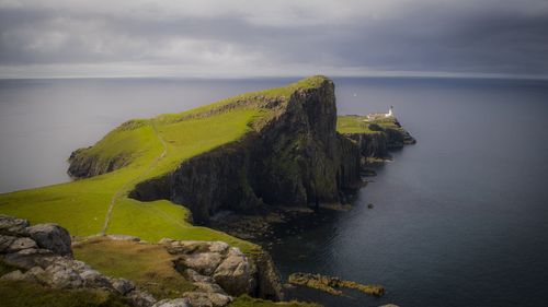
Wester Ross
The western seaboard of the old county of Ross-shire, Wester Ross, blends all the classic elements of Scotland’s coastal scenery – dramatic mountains, sandy beaches, whitewashed crofting cottages and shimmering island views – in spectacular fashion. Though popular with generations of adventurous Scottish holiday-makers, only one or two places feel blighted by tourist numbers, with places such as Applecross and the peninsulas north and south of Gairloch maintaining an endearing simplicity and sense of isolation. There’s some tough but wonderful hiking to be enjoyed in the mountains around Torridon and Coigach, while boat trips out among the islands and the prolific sea- and birdlife of the coast are another draw. The main settlement is the attractive fishing town of Ullapool, port for ferry services to Stornoway in the Western Isles, but a pleasant enough place to use as a base, not least for its active social and cultural scene.
Walks around Torridon
There can be difficult conditions on virtually all hiking routes around Torridon, and the weather can change rapidly. If you’re relatively inexperienced but want to do the magnificent ridge walk along the Liathach (pronounced “lee-ach”) massif, or the strenuous traverse of Beinn Eighe (pronounced “ben ay”), join a National Trust Ranger Service guided hike.
For those confident to go it alone, one of many possible routes takes you behind Liathach and down the pass, Coire Dubh, to the main road in Glen Torridon. This is a great, straightforward, full-day walk, covering thirteen miles and taking in superb landscapes. Another rewarding walk, even in rough weather, is the seven-mile hike up the coast from Lower Diabaig, ten miles northwest of Torridon village, to Redpoint. On a clear day, the views across to Raasay and Applecross from this gentle path are superlative, but you’ll have to return along the same trail, or else make your way back via Loch Maree on the A832.
The West Highland Railway
Scotland’s most famous railway line is the brilliantly engineered West Highland Railway, running from Glasgow to Mallaig via Fort William. The line is in two sections: the southern part travels from Glasgow Queen Street station along the Clyde estuary and up Loch Long before switching to the banks of Loch Lomond on its way to Crianlarich, where the train divides with one section heading for Oban. After climbing around Beinn Odhar on a unique horseshoe-shaped loop of viaducts, the line traverses desolate Rannoch Moor, where the track had to be laid on a mattress of tree roots, brushwood and thousands of tons of earth and ashes. The train then swings into Glen Roy, passing through the dramatic Monessie Gorge and entering Fort William from the northeast.