Discover more places in Iceland


Planning your own trip? Prepare for your trip
Use Rough Guides' trusted partners for great rates
written by
Rough Guides Editors
Spread either side of Reykjavík, southwestern Iceland extends barely 200km from end to end, but nowhere else are the country’s key elements of history and the land so visibly intertwined. Here you’ll see where Iceland’s original parliament was founded over a thousand years ago, sites that saw the violence of saga-age dramas played out, and where the country’s earliest churches became seats of power and learning. Culture aside, if you’re expecting the scenery this close to the capital to be tame, think again: the southwest contains some of Iceland’s most iconic – and frequently explosive – landscapes, compelling viewing whether used as a simple backdrop to a day’s drive, or as an excuse to spend a week trekking cross-country.
Southwest of Reykjavík, bleak, semi-vegetated lavafields characterize the Reykjanes Peninsula, site of the international airport at Keflavík, though the famous Blue Lagoon adds a splash of colour. Due east of Reykjavík, a clutch of essential historical and geological features – including the original parliament site at Þingvellir, Geysir’s hot water spouts, and Gullfoss’ rainbow-tinged cataracts – are strung out around the Golden Circle, an easy route tackled by just about every visitor to the country.
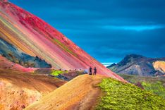
Then there’s the central south, a broad stretch of grassy river plains further southeast again, whose inland regions give way to a blasted landscape surrounding the volcano Hekla and hot springs at Landmannalaugar, itself the starting point for the popular four-day Laugavegur hiking trail. Back on the coast, the rolling farmland of Njál’s Saga country is dotted with landmarks from this famous tale, not to mention beautiful scenery and further hiking around the glaciated highland valley of Þórsmörk.
The south coast is decorated with spectacular waterfalls fringing the Eyjafjallajökull and Mýrdalsjökull ice caps, both of which harbour active volcanoes, before the highway runs east out of the region via the attractive coastal hamlet of Vík. Offshore, a short ferry ride from the mainland lands you on Heimaey, the small, intimate core of the Westman Islands, alive with birdlife and bearing further recent proof of Iceland’s unstable volcanism.
Tip from Rough Guides: also learn about the best ways to get to Iceland.
East of Reykjavík on the Ringroad, the hothouse town of Hveragerði and nearby transit hub Selfoss are the gateway to Iceland’s central south, a swathe of fertile plains watered by the Hvítá, Rangá and Þjórsá – Iceland’s longest river at 230km – and the clutch of bulky glaciers to the east. The inland area here cowers beneath Hekla, a destructive volcano whose antics have put paid to regional farming at least twice in recorded history, with tracks past the mountain leading to hot springs and brightly coloured hills at Landmannalaugar, right on the edge of Iceland’s rugged Interior. If you enjoy the great outdoors, Landmannalaugar’s surrounds are worth a trip to Iceland in their own right, not least for the superb four-day Laugavegur hiking trail. If you’re not that serious, consider less demanding tracks over the hills above Hveragerði, also featuring steaming hot springs.
Reykjadalur, the steamy heights above Hveragerði, is covered in trails and hot springs, its hillsides stained by volcanic salts and heathland plants, and, in fine weather, offering inspiring views coastwards – not to mention the thermal streams, warm enough to bathe in, so take your swimwear. Maps of the area, available at the information centre, have all trails and distances marked; on the ground, many routes are staked out with coloured pegs. As always, carry a compass and come prepared for bad weather.
For an easy four-hour circuit, follow Breiðamörk north out of town for about forty minutes to a bridged stream at the base of the fells, from where a pegged trail heads uphill. Crossing the muddy top, you descend green boggy slopes into Reykjadalur (Steam Valley), named after the hot stream that runs through the middle. You need to wade across this at any convenient point – there’s a shallow ford – and then follow the far bank at the base of the forbidding rubble slopes of Molddalahnúkar, past a number of dangerous, scalding pools belching vapour and sulphur – stay on the path. At the head of the valley, 3km from the bridge, the stream bends west, with Ölkelduhnúkur’s solid platform straight ahead and the main trail following the stream west along Klambragil, another steamy valley. There are a number of shallow, warm places to soak here – just test the water temperature before getting in.
Heading southeast from the Þjórsá on the Ringroad, the first thing you’ll notice are disproportionate numbers of four-wheel-drives towing boxes, and a wide, rolling expanse of pasture, positively reeking of horse. This is one of Iceland’s premier horse-breeding areas, with Oddhóll, the country’s biggest stud farm, near the small town of Hella. The countryside between here and the distant slopes of Eyjafjallajökull to the east comprises the plains of the two-pronged Rangá river system, famed for its salmon and the setting for much of the action of Iceland’s great medieval epic, Njál’s Saga.
With the highway towns of Hella or Hvolsvöllur as a base, getting out to a handful of the saga sites is straightforward enough in your own vehicle, even if you do find more in the way of associations rather than concrete remains when you arrive. A more obvious draw is Þórsmörk, a beautifully rugged highland valley only accessible by four-wheel-drive or hiking trails from Landmannalaugar and Skógar; you’re also within striking distance of the ferry to Heimaey in the Westman Islands. Ringroad buses pass through Hella and Hvolsvöllur year-round, as do additional summer services to Þórsmörk and Landmannalaugar.
Speared in the belly, Þorgrim dropped his shield, slipped, and fell off the roof. He walked back to Gizur and the rest. “Is Gunnar at home?”, asked Gizur, looking up. Þorgrim replied, “You’ll have to find that out for yourself – but his spear certainly is.” And then he fell dead.
There’s nothing to beat the laconic, hard-bitten delivery of Njál’s Saga, Iceland’s gripping tale of Viking-age clan warfare. The story centres on the life of Njál Þorgeirsson and his family, who are casually ensnared in a minor issue that somehow escalates into a frightful, fifty-year feud. Bound by their own personalities, fate, and sense of honour, nobody is able to stop the bloodshed, which ends only after the original characters – and many of their descendants – have been killed. But there’s far more to Njál’s Saga than its violence, and the tale paints a vivid picture of Iceland at what was, in some ways, an idyllic time: the power of the Alþing at Þingvellir was at its peak, and the country’s free settlers lived by their own efforts on farming and freebooting.
The tale splits into three uneven parts, beginning in the late tenth century at a point where the fate of several participants is already intertwined. Gifted with foresight and respected by all, Njál himself is often a background figure, mediating and advising rather than confronting or fighting, but his sons play a far more active role, especially the proud and ferocious Skarp-héðinn. Njál’s best friend is the heroic Gunnar Hámundarson of Hlíðarendi, whose superb martial skills and physical prowess never get in the way of his generosity or sense of justice. Balancing this nobility is the malevolent Mörð Valgarðsson, a second cousin of Gunnar’s who spends the saga’s first third plotting his downfall.
Early on in the tale Gunnar marries “Thief-eyed” Hallgerð, a thorny character who provokes a violent feud with Njál’s household. Njál and Gunnar remain friends, but Njál’s sons are drawn into the fray by the murder of their foster-father, and the cycle of payback killings begins. Mörð sees his chance, and manipulates various disreputable characters into picking fights with Gunnar, who emerges undefeated yet increasingly worn down from each confrontation. After one fight too many, Gunnar is outlawed – exiled from Iceland – but finds himself unable to leave his homeland, and is hunted down to Hlíðarendi by a posse led by Mörð and the upstanding chieftain Gizur the White. When Gunnar’s bowstring snaps during the siege, Hallgerð spitefully refuses to give him two locks of her hair to restring the weapon: “To each their own way of earning fame,” Gunnar memorably responds, and is cut down.
After an interlude describing Iceland’s conversion to Christianity in 1000, the violence sparked by Hallgerð thirty years earlier resurfaces when Njál’s sons kill her distant relative, the arrogant Þráin Sigfússon. Attempting to placate Þráin’s family, Njál adopts his son Höskuld and buys him a priesthood, and for a while all seems well. But resentment at this favouritism eats away at Njál’s sons, and, encouraged by Mörð – who, now that Gunnar is dead, has shifted his vindictive attentions to Njál – they murder Höskuld. Höskuld’s influential father-in-law Flósi of Svínafell agrees initially to a cash settlement for the murder, but Njál inadvertently offends him: confrontation is inevitable and the 80-year-old Njál, bowing to fate, retreats with his sons to his homestead Bergþórshvoll. Flósi and his men torch the building, killing all but Njal’s son-in-law Kári.
Public opinion against the burning of Njál runs so high that at the following Alþing Kári is able to confront Flósi and his allies – now known as the Burners. Mörð stirs up trouble again and a pitched battle breaks out; in the aftermath, all but Kári accept the Alþing’s conditions for peace, which banish Flósi and the Burners from Iceland until tempers have cooled. For his part, Kári swears vengeance, and the action follows his peregrinations around Europe as he hunts down his enemies. Returning to Iceland, Kári’s ship is wrecked at Ingólfshöfði off the southeast coast; walking inland through a blizzard he finds sanctuary at Svínafell and becomes reconciled with Flósi, bringing Njál’s Saga to an end.
Sæmundur Sigfússon is the subject of several legends, including one in which the devil – disguised as a seal – offered to carry him back to Iceland from France so that Sæmundur could apply for the post at Oddi. When they were within sight of the shore, the resourceful Sæmundur brained the devil with a psalter, swam to safety, and got the job. Less to his credit, he’s also held responsible for causing Hekla’s 1104 eruption by tossing a keepsake from a jilted lover – who turned out to be a witch – into the volcano.
Southeast from the Þórsmörk junction, the Ringroad finds itself pinched between the coast and the Eyjafjallajökull ice cap. Though dwarfed in scale by its big sister Mýrdalsjökull immediately to the east, Eyjafjallajökull’s 1666m apex is southwestern Iceland’s highest point, and the mountain has stamped its personality on the area: an active volcano smoulders away below the ice, responsible for major eruptions in the seventeenth and nineteenth centuries. In 2010 Eyjafjallajökull awoke from dormancy in a fairly small-scale event, but one in which massive clouds of ash, swept southwards by high-altitude winds, caused chaos across Europe by grounding aircraft – something that (along with listening to foreign reporters’ stumbling efforts to pronounce “Eyjafjallajökull”) created a perverse sense of pride in Iceland.
The base for exploring all this is the Ringroad hamlet of Skógar, with its magnificent waterfall and superb hike to Þórsmörk via a pass between Eyjafjallajökull and Mýrdalsjökull at Fimmvörðuháls, site of the 2010 eruption. Moving down the coast, mountain ridges supporting Mýrdalsjökull – and occasional outlying glaciers, such as Sólheimajökull – intrude further and further towards the sea, finally reaching it around Iceland’s southernmost tip, Dyrhólaey, where they form impressively sculpted cliffs, home to innumerable seabirds. Past Dyrhólaey, the sleepy village of Vík has black-sand beaches, more birds and some easy walks, and marks the beginning of the long cross-desert run into southeastern Iceland.
The shoreline stretches from Reykjavik to Jökulsarlon glacier lagoon with plenty of natural sights and wildlife spottings along the way. The Route 1 highway allows for easy accessibility, therefore, making it popular for those exploring Iceland.
The South Coast of Iceland is well-known for its numerous species of birds, particularly those who nest through all seasons. Keep an eye out on the coastline for seals, whales and dolphins.
Beneath the spectacular Eyjafjallajökull sit waterfalls Seljalandsfoss and Skogafoss. Large in size and roaring loud with rushing water, the waterfalls are a great stop and the most recognised falls on the South Coast.
On the black sandy beach of Sólheimasandur sits the abandoned DC-3 plane wreck belonging to the US Navy that crashed in 1973. Eerily quiet and mysterious, visiting the wreck at the right time has a movie-like sci-fi effect.
Both Mountain Guides and Arcanum run 1–3hr ice-walking and climbing excursions through the summer at Sólheimajökull; contact them in advance for details. You don’t need prior experience and they supply crampons and ice axes. Arcanum also offers snowmobile trips across the upper heights of Mýrdalsjökull from Sólheimskáli, a mountain hut 10km inland off the Ringroad along the rough gravel Route 222. Call ahead if you need a pickup from anywhere between Reykjavík and Vík, though this will add considerably to the price.
The 25km hiking trail from Skógar, over the Fimmvörðuháls pass between the Eyjafjallajökull and Mýrdalsjökull ice caps, then down the other side to Þórsmörk, offers spectacular views and traverses lava from the 2010 eruption at Eyjafjallajökull. Although it’s feasible to do the whole thing in under ten hours, many people spread the trip over two days, overnighting at one of the two mountain huts en route, for which bookings are essential. The trail is usually passable without equipment from around mid-June to September; outside these times you’ll probably need an ice axe to cut steps during the descent to Þórsmörk, and possibly crampons. Whatever the time of year, come prepared for possible rain and snow, poor visibility and cold; the track is easy to follow in clear weather, but play safe and carry a compass and Mál og menning’s Landmannalaugar-Þórsmörk-Fjallabak map.
The trail starts by taking the staircase up Skógarfoss, then follows the river uphill over a muddy, shaly heath carpeted by thick patches of moss. There are many small waterfalls along the way, each of them unique: some twist through contorted gorges, others drop in a single narrow sheet, bore tunnels through obstructive rocks, or rush smoothly over broad, rocky beds. Around 8km along you cross a bridge and leave most of the vegetation behind for a dark, rocky plain flanked by the smooth contours of Eyjafjallajökull and Mýrdalsjökull. It’s another hour from here, following marker poles across gravel and snowfields, to the recently refurbished Baldvinsskali hut (5000kr). Alternatively, push on for another forty minutes to the larger second hut, Fimmvörðuskáli (893 4910; 5500kr), actually just west off the main trail.
From here you’re halfway along and crossing Fimmvörðuháls (1043m), the flat pass in between the two glaciers; there’s a pale blue tarn and then a gentle ascent to where the path weaves around and over the rough lavafields created in 2010. You end up at the top of a slope with a fantastic vista of Þórsmörk laid out below, Mýrdalsjökull’s icy outrunners hemming in the view to the east. The slope is snow-covered well into the summer and the quickest way down is to cautiously slide it on your backside, using your feet as brakes. This brings you to Heljarkambur, a narrow, 50m traverse with a vertical rockface rising on one side and a steep snowfield dropping 75m on the other; winds here can be appalling. At the far end is the flat, muddy gravel plateau of Morinsheiði: look at where steaming new lava is dispersing the glacier edge in a noisy waterfall at the neck with Heljarkambur. Cross the plateau and it’s a straightforward descent to Þórsmörk (though the short, knife-edge “Cat’s Spine” ridge can be nervous work, despite a helpful chain) and the Básar hut.
Top image: Seljalandsfoss waterfall © Nido Huebl/Shutterstock
Use Rough Guides' trusted partners for great rates
written by
Rough Guides Editors


.jpg)