

Planning your own trip? Prepare for your trip
Use Rough Guides' trusted partners for great rates
written by
Rough Guides Editors
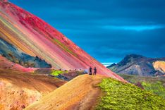
Compared with the neighbouring West Fjords, the scenery of Northwest Iceland is much gentler and less forbidding – undulating meadows dotted with isolated barns and farmhouses are the norm here, rather than twisting fjords, though there are still plenty of impressive mountains to provide a satisfying backdrop to the coastline. However, what makes this section of the country stand out is the site of two of Iceland’s great historical sites, most notably Þingeyrar, once the location for an ancient assembly and monastery where some of Iceland’s most outstanding pieces of medieval literature were compiled.
As the legendary Ringroad heads northeast from Þingeyrar on its way to Akureyri, the best place to break the long journey is likeable Sauðárkrókur, enlivened by stunning sea views out over Skagafjörður and Drangey island, once home to saga hero Grettir, who bathed here in the nearby natural hot pool now named after him. Just half an hour’s drive away is the north’s second great historical site, Hólar í Hjaltadal, which functioned as the ecumenical and educational centre of the north of the country between the twelfth century and the Reformation. A further detour up Route 76, via the Vesturfarasetrið (Icelandic Emigration Centre) at Hofsós, brings you to the pretty fishing village of Siglufjörður.
Slicing deep into the coastline of this part of northern Iceland, Eyjafjörður is the country’s longest fjord and was for centuries Akureyri’s window on the world as ships sailed its length to deliver their goods to the largest market in northern Iceland. Today, though, fisheries have taken over as the town’s economic mainstay, profiting from the rich fishing grounds found offshore. With a population of fifteen thousand making it the largest town outside the Reykjavík area, not only does Akureyri boast a stunning setting at the head of Eyjafjörður, but it’s also blessed with some of the warmest and most stable weather anywhere in the country.
Though the sleepy villages of Dalvík, with ferry connections across to Hrísey, and Ólafsfjörður both make excellent day-trips once you’ve exhausted Akureyri, it’s more fun to head out to the beautiful island of Grímsey, where the cliffs and skies are alive with around sixty different species of screeching birds, many of which consider you an unwelcome intruder.
Compared with the neighbouring West Fjords, the scenery of Northwest Iceland is much gentler and less forbidding – undulating meadows dotted with isolated barns and farmhouses are the norm here, rather than twisting fjords, though there are still plenty of impressive mountains to provide a satisfying backdrop to the coastline. However, what makes this section of the country stand out is the site of two of Iceland’s great historical sites, most notably Þingeyrar, once the location for an ancient assembly and monastery where some of Iceland’s most outstanding pieces of medieval literature were compiled.
Tip from Rough Guides: also learn about the best ways to get to Iceland.
The 230km stretch of the Ringroad between Brú (a filling station at the junction of Routes 1 and 61) and Akureyri is one of its least interesting, and many travellers speed through it as quickly as possible. But while the Ringroad itself holds few attractions, it is worth detouring off it: highlights include the Vatnsnes peninsula, north of the workaday village of Hvammstangi, 5km or so north of the Ringroad, where there’s a good chance of seeing seals; the north’s great historical sites of Þingeyrar and Hólar í Hjaltadal; and two fine examples of small-town Iceland, Sauðárkrókur and Siglufjörður.
Barely a kilometre outside Blönduós, where the Ringroad swings sharply inland to follow the course of Langidalur valley towards Varmahlíð, Route 74 strikes off north for 23km towards the Skagi Peninsula, a lonely, uninhabited landscape of desolate rocky moors and tussocky grassland studded with tarns. Beyond the peninsula’s one and only town, Skagaströnd, the unsurfaced Route 745 begins its tour of the peninsula proper.
Skagaströnd is a rather ugly place dominated by a hulking fish factory down by the harbour and the brooding heights of the Spákonufell (646m) mountain, which bears down on the settlement from across the main road. Although trading began here centuries ago, there’s precious little to show for it, since most buildings date from a tasteless expansion during the 1940s herring boom.
The town's new museum, Spákonuhof, focuses on the life and times of the area’s first named inhabitant, Þórdís the fortune-teller (c.932–75), who lived on nearby Spákonufell in the late tenth century. On entering the museum you’ll come face to face with a wax model of Þórdís (even though there’s actually no description of what she looked like), a couple of stuffed ravens and a mock-up of a wooden shack with a thatched roof – an approximation of the hut she might have lived in. Other than a tapestry portraying the key events in her life, notably efforts to raise Iceland’s first Christian missionary, there’s little else here to detain you.
From Skagaströnd, Route 745 follows the eastern shoreline of Húnaflói bay as it heads north around the peninsula. Roughly 15km north of Skagaströnd, the 10km-long cliffs at Króksbjarg and the glittering waterfall where the Fossá river tumbles down the cliff-face into the sea are an essential first stop. Beyond Króksbjarg, the road passes several deserted farms before reaching the sweeping bay of Kaldranavík, at the tip of the peninsula, which offers some truly magnificent ocean vistas. Having weaved past the remote farm of Hraun, at Hraunsvík on the northeastern extremity of the peninsula, the road finally veers south following the coastline of Skagafjörður fjord for the rugged sheer sea cliff Ketubjörg (signed from the road), actually the remains of an old volcano, and the accompanying rock pillar, Kerling, just off the shore to the northeast. From here it’s an uneventful and easy drive on towards Sauðárkrókur.
Just 6km north of the Ringroad along Route 721, the ancient site of Þingeyrar is worth a stop-off on your journey to Akureyri. If you don’t have your own transport, you’ll find that it’s a straightforward walk from the Ringroad. This was originally the site of a legislative assembly during the Icelandic Commonwealth, and the first Bishop of Hólar, Jón Ögmundarson, pledged to build a church and an associated farm here if God were to relieve a severe local famine. When the land began to regain its productivity, the bishop took things one step further and established Iceland’s first monastery, Þingeyraklaustur, here in 1133, which remained in existence until the Reformation in 1550. The monks went on to copy and transcribe some of the country’s most outstanding pieces of medieval literature, and it was on this spot that many of the sagas were first written down for posterity.
There’s nothing left of the monastery, but a superb nineteenth-century church, Þingeyrakirkja, now stands adjacent to where the monks once lived and worked. Constructed of large blocks of basalt, brought here on sledges dragged across the nearby frozen lagoon of Hóp, the church was the first building on the site to be made of stone – all previous structures had been of turf – and it brought much admiration from local worthies. Although its grey mass is indeed an impressive sight, clearly visible from miles around, it’s the interior that really makes a trip here worthwhile, with stark white walls setting off the blue ceiling, painted with a thousand golden stars, and the simple green pews. The wooden pulpit dates from 1696 and is thought to come from Denmark or Holland, whereas the altarpiece, inset with religious figures made of alabaster, dates from the fifteenth century and was originally made in the English town of Nottingham for the monastery there.
From Hvammstangi, you’ll need your own transport to follow Route 711 as it heads northeast around the Vatnsnes peninsula, a wild and uninhabited finger of land on the eastern side of Húnaflói known for its superb views out over the bay towards the needle-sharp peaks of the Strandir coast in the West Fjords. While ascending tiers of craggy, inaccessible hills form the spine of the peninsula, the land closer to the shore is surprisingly green and is given over to grazing land for horses; you’ll also spot flocks of greylag geese, and seals on the beach at Ósar. Around 30km from Hvammstangi, the café at the tiny settlement of Geitafell offers a welcome opportunity to break your journey.
On the promontory’s more sheltered eastern coast, 29km north of the Ringroad along Route 711 and 18km east of Geitafell, there’s a seal-breeding ground at the the farm-cum-youth hostel, Ósar, where adult seals and their young can be spotted lolling idly on the black volcanic sands during June and July – a rare opportunity to see these appealing creatures at close quarters. A short path leads down to the sands from the friendly youth hostel. Ósar is also the location of the 15m-high Hvítserkur rock formation, a striking landmark just offshore. Sculpted by the tremendous force of the sea, this craggy rock looks like a forbidding sea monster rearing up from the waves.
From the harbour outside the seal centre, the handsome former fishing boat, Brimill, sails across to the sands on the southwestern shores of Midfjörður, a favourite resting spot for seals; as there is no road access to the area, the boat trip provides the only opportunity to watch seals in their natural environment from Hvammstangi and sightings are virtually guaranteed. Trips are run by Selasigling, from mid-May to September.
East from Blönduós along the Ringroad, it’s 25km to where Route 732 heads south to join the Kjölur Route (Route 35) across the Interior to Gullfoss. About the same distance again along the Ringroad, the minuscule settlement of Varmahlíð is of interest only as the junction with Route 75 heading north up to Sauðárkrókur via Glaumbær farm, and for one of Iceland’s best activity centres specializing in whitewater rafting.
About 14km from Varmahlíð up Route 75 is the immaculately preserved historical farm, Glaumbær. Though founded in Settlement times, Glaumbær’s current row of wood-fronted turf-walled and turf-roofed dwellings dates from 1750 to 1879, and was inhabited up until 1947. With their lop-sided, hobbit-like construction (such as wooden-frame windows set into the grassy walls), the buildings are both charmingly rustic and a powerful reminder of the impoverished lifestyle many people led in Iceland during the eighteenth and nineteenth centuries.
Adjacent to the cottages, a timber building houses the Skagafjörður folk museum, with a collection of rustic implements once used on the farm, from spinning wheels to brightly painted clothes chests. Not only does the farm demonstrate centuries-old Icelandic building techniques, it’s also where Snorri Þorfinsson, the first American born of European parents (in 1003), is buried; Snorri came to Iceland with his parents and lived out his life on the farm here.
Set at the base of the broad, north-facing Skagafjörður, 25km north of Varmahlíð, Sauðárkrókur is the second-largest town on the northern Icelandic coast, with a population of 2600. It’s a likeable spot, occupying a triangle of suburban streets bordered by fjordside Strandvegur, Hegrabraut and Skagfirðingabraut. Sauðárkrókur’s brightly painted houses and wide open spaces, with views of the bustling harbour on the edge of its centre, lend a pioneering edge to the town, and wandering around the streets is a pleasant enough way to pass an hour or two, popping in at the fascinating fish skin tannery on the way. The main attractions, though, are the boat trips to the nearby island of Drangey and a dip in Grettislaug hot pool, both connected to Iceland’s classic outlaw tale, Grettir’s Saga, and horseriding tours out into the surrounding countryside.
From Sauðárkrókur, it’s a 100km run along routes 75 and 76 up the eastern side of Skagafjörður to Siglufjörður. It’s worth making the short detour off Route 76 to Hólar í Hjaltadal, which was northern Iceland’s ecumenical and educational centre until the Reformation. Today, this tranquil place in the foothills of Hjaltadalur valley consists solely of a cathedral and an agricultural college, and is a remote and peaceful spot that’s worth seeking out – particularly if you fancy hiking, since a trail leads from here over to Dalvík. Beyond Hólar, Route 76 leads north to Hofsós, another diminutive settlement, best known as a study centre for North Americans of Icelandic origin keen to trace their roots, before rounding the headland and pressing on to Siglufjörður.
Seventeen kilometres up Route 76 from the Hólar junction, Hofsós is a tiny, nondescript village on the eastern shores of Skagafjörður, consisting of one street and a tiny harbour, with a population of around two hundred. Nonetheless, it does have two good reasons to stop: a visit to the Vesturfarasetrið offers a fascinating insight into Icelandic emigration to North America; and a swim in one of the country’s most beautifully located outdoor pools.
Hofsós is primarily a base for the hundreds of Americans and Canadians of Icelandic descent who come here to visit the Vesturfarasetrið, or Icelandic Emigration Centre, housed in several buildings beautifully set on the seafront by the harbour. The centre’s genealogy and information service is located in a red-roofed building furthest from the harbour, Gamla Kaupfélagshúsið, which is where you’ll find the main exhibition of the migration story, “New Land, New Life”, detailing the living conditions of Icelanders who moved to America at the end of the nineteenth century and where they settled. Next door, in the Frændgarður building, the Silent Flashes exhibition of around 400 photographs, taken in America between 1870 and 1920, traces the lives of some of the 20,000 Icelanders who emigrated west over the sea. Finally, in the Konungsverslunarhúsið, before the footbridge across to the main exhibitions, there’s a moving display of black-and-white photographs, known as the “Prairies Wide and Free” exhibition, recounting the lives of children who emigrated to North Dakota.
Designed by the same architect responsible for the Blue Lagoon, on the Reykjanes Peninsula, the new swimming pool in Hofsós is quite simply magnificent. It may not be Olympic size, but because it has been built into the hillside above the sea, the views over to Drangey are breathtaking. It’s not strictly an infinity pool, but the impression you get as you swim in the geothermal waters is that you’re right next to the sea’s edge. The pool was donated to the town just before the economic crash by two bankers’ wives, frustrated by the fact they had nowhere to swim.
Sailing from the Hofsós's harbour, down by the emigration centre, Hafogland operate boat tours out into Skagafjörður: a two-hour excursion, perfect for birdwatching, will take you out to Malmey island as well as to the curiously shaped Þórðarhöfði headland which extends into the fjord north of Hofsós via a narrow, pebbly spit of land. Another option is a sea-angling tour including all equipment.
Lying 12km down Route 767, which runs east off Route 76 about thirty minutes from Sauðárkrókur, the hamlet of Hólar í Hjaltadal, or simply Hólar, was very much the cultural capital of the north from the twelfth until the eighteenth century: monks studied here, manuscripts were transcribed and Catholicism flourished until the Reformation. Now home to just sixty-odd people, most of whom work at the agricultural college – this and the cathedral are the only buildings remaining – it was the site of the country’s first printing press in 1530, set up by Iceland’s last Catholic bishop, Jón Arason (who was beheaded twenty years later at Skálholt for his resistance to the spread of the Reformation from the south).
A church has stood on this spot since Arason’s time, but the present cathedral was built in 1759–63 in late Baroque style, using local red sandstone from the mountain Hólabyrða, and is the second-oldest stone building in the country. Inside, the fifteenth-century alabaster altarpiece over the cathedral’s south door is similar in design to that in the church at Þingeyrar, and was likewise made in Nottingham, England. The main altarpiece, with its ornate carvings of Biblical figures, originated in Germany around 1500 and was given to the cathedral by its most famous bishop. Arason’s memory is honoured in the adjacent bell tower: a mosaic of tiny tiles, by Icelandic artist Erró, marks a small chapel and headstone, under which the bishop’s bones are buried.
Located in the mouth of Skagafjörður, equidistant between Reykir on the fjord’s west coast and the headland, Þórðarhöfði, on the eastern shore, the island of Drangey makes a great day-trip from Sauðárkrókur. Now a bird sanctuary where kittiwakes, puffins and guillemots can be seen in abundance, the steep-sided, flat-topped island, which resembles an arrow pointing north, is best visited on the three- or four-hour boat tours, operated by Drangey Tours, which leave from the harbour at Reykir. Offering an unbeatable combination of birdlife and history, the tour is easily one of the best on offer in northern Iceland – although it’s not for the faint-hearted, given the steep climb required once ashore and the dizzying drops as you ascend.
From the boat moorings, a narrow winding path streaks steeply up rocky cliffs to the grassy meadow at the summit of Drangey's 180m-high plug of palagonite rock. The deep hollow in the turf here, where the bedrock shows through, was once the hideout of Grettir the Strong (or Grettir Ásmundarson), hero of Grettir’s Saga. The island’s northern summit is accessible only by climbing a rusty ladder, erected by local bird hunters, which overhangs an area of crumbling rock – definitely not one to attempt if you’re afraid of heights. Incidentally, for fresh water Grettir depended on a spring virtually hidden under a steep rock overhang on the island’s southern cliff. Even today, the only way to reach the source is to clamber hand over hand down a knotted rope, trying not to look down at the 500m sheer drop beneath.
Iceland’s great outlaw story, Grettir’s Saga centres on a man who is born out of his time: Grettir has the wild spirit of a Viking, but lives a generation after the country’s conversion to Christianity. Outlawed for three years in his youth for killing a man, Grettir spends the rest of his life performing great deeds – often for the benefit of others – yet something bad always seems to result from his actions, isolating him from his fellow men and eventually forcing him into perpetual banditry. In the end, he and his brother Illugi settle on Drangey, living off sheep left here by local farmers. Yet even as he is granted a pardon at the Alþing for his past crimes, Grettir is hunted down by his enemies and finally killed after three years on the island.
The stretch of bitterly cold sea between Drangey and the farm at Reykir on the mainland opposite is known as Grettir’s Swim, which the outlaw reputedly swam across to fetch the glowing embers he’d spotted on the mainland after his own fire had gone out; its 7.5km are still sometimes swum for sport, despite the fact that the water temperature in summer barely rises above 9°C. However, if the bawdy humour of the sagas is anything to go by, this feat certainly takes its toll, even on Viking superheroes; according to Grettir’s Saga two young women, finding Grettir lying naked on the ground numb after his swim through the freezing waters, declare, “He is certainly big enough in the chest but it seems very odd how small he is farther down. That part of him isn’t up to the rest of him,” to which Grettir retorts, “The wench has complained that my penis is small and the boastful slut may well be right. But a small one can grow and I’m still a young man, so wait until I get into action, my lass.”
Having wound northeast around the convoluted coast for 60km from Hofsós, Route 76 cuts through an unpleasantly dark and narrow single-lane tunnel to land you at the enjoyably remote fishing port of Siglufjörður (known locally as Sigló), a highlight of any trip to the northwest. The country’s most northerly town, Siglufjörður clings precariously to the foot of steep mountain walls which enclose an isolated narrow fjord on the very edge of Iceland: the Arctic Circle is barely 40km away and you’re as far north here as Canada’s Baffin Island and central Alaska. Winters can be particularly severe, though in summer, Siglufjörður makes an excellent base from which to hike across the surrounding mountains.
Today, Siglufjörður’s heyday as a herring-fishing town is long gone and the place is considerably quieter, with a population of just thirteen hundred people. It’s a pleasant spot, consisting of a handful of parallel streets with unkempt multicoloured homes grouped around the main street, Túngata, which turns into Snorragata as it approaches the harbour, busy with the goings-on of a low-key fishing port. Here, you’ll see fishermen mending their nets in the shipyard and fish hanging out to dry – the town still produces kippers (smoked herring) from a factory down by the harbour. Once you’ve seen the herring museum there’s some excellent hiking to be had along the trails that lead up out of the fjord.
Several excellent day hikes can easily be undertaken from Siglufjörður. The trails described below are shown on the hiking map of Siglufjörður available at the herring museum.
The best of the shorter routes (5–7hr), forming a clockwise circle around the town, begins at the southern edge of Siglufjörður, where the road veers left around the head of the fjord. Follow the walking path up Eyrafjall, heading towards the Dalaskarð pass, then over the mountain tops and up Hafnarfjall, from where there’s an excellent view over the fjord, the surrounding peaks and even Grímsey. From here it’s an easy climb up Hafnarhyrna (687m), the highest point on Hafnarfjall and the starting point for the easy descent towards the bowl-shaped hollow of Hvanneyrarskál, a well-known lovers’ haunt during the herring boom. From this hollow, a road leads back down into town.
A second, longer trail (10–14hr) begins beyond the disused airport on the eastern side of the fjord (follow the main road through the village to get there) and leads southeast up the valley of Kálfsdalur, which begins just above the lighthouse beyond the airport, past Kálfsvatn lake, over the Kálfsskarð pass (450m) before descending into Nesdalur valley on the other side of the ridge. The trail then leads north through the valley to the coast and the deserted farm, Reyðará. From the farm, the trail leads west along the steep slopes of Nesnúpur (595m), passing a lighthouse and several abandoned huts, built by the American military during World War II as a radar station. Once back on the eastern side of the fjord the path trail continues along the shoreline, towards the disused airport and Siglufjörður.
From 1900 to 1970, Siglufjörður was the herring capital of the North Atlantic. Hundreds of fishing boats would crowd into the tiny fjord to unload their catches onto the rickety piers that once stretched out from the quayside, where herring girls, as they were known, would gut and salt them. During a good season, casual labour and the number of fishermen (who were, in the early part of the century at any rate, primarily Norwegian) could swell the town’s population threefold, to over ten thousand.
Divided into three sections, Síldarminjasafn Íslands (the Herring Era Museum) expertly brings Siglufjörður’s past to life. The best idea is to start in the Bátahúsið and then work your way on to the old herring factory, Grána, before finishing in Róaldsbrakki, the building which was once home to the herring girls.
Home to a collection of ten ships, the Bátahúsið (boathouse) offers a fine introduction to some of the vessels that operated out of Siglufjörður during the herring era. The ships are dry-moored around a mock-up of a quayside as it would have looked in the 1950s, and you can even clamber on board two of them; the largest boat in the museum is the Týr SK33, made of oak, which operated until 1988, when more modern steel vessels made its design obsolete.
Next door to the boathouse, you can peep inside Grána, the reconstructed herring factory. A whole host of machines help to give an idea of how Siglufjörður once produced vast amounts of fish meal and oil for the European market; the oil was used, for example, to light towns and cities across the continent as well as in the production of Brylcreem, Nivea face cream and Lux soap.
The herring girls’ story is brought to life in photographs and exhibits inside the Róaldsbrakki building, alongside Grána. This old salting station once housed around fifty herring girls – you can still see graffiti, daubed in nail varnish, on the walls of the second-floor room where they once slept, alongside faded black-and-white photographs of heart-throb Cary Grant. There’s usually a couple of atmospheric old films showing, too, which give an idea of the conditions of the time and the work that the herring girls carried out.
Running up Eyjafjörður’s western flank from Akureyri, Route 82 affords stunning views over icy waters to the glacier-formed mountains which serve as a protective wall all around the fjord. If you have time, it’s well worth making the trip from Akureyri to see not only the mountains but also the rich farmland hereabouts, which is heavily grazed during the summer by cattle and sheep. The long hours of daylight in this part of Iceland, coupled with mild temperatures, make excellent growing conditions for various crops, and the small white dots you’ll see in the fields are barrel-shaped bundles of hay, neatly packaged in white plastic, to provide the animals with much needed food during the long months of winter. Noted for its hundreds of wild ptarmigan, the highlight of any trip up the fjord is the island of Hrísey, near the mouth of Eyjafjörður and overlooked by the fishing village of Dalvík, itself the starting point for some excellent hiking and whale-watching tours. Beyond here, a dark tunnel slices through the exposed headland, Ólafsfjarðarmúli, to reach the isolated village of Ólafsfjörður, another notable place from which to see whales. Two new tunnels now link the village with Siglufjörður, now just 17km away, making it possible to continue your journey via the north coast south to Varmahlíð and the Ringroad.
From Dalvík, Route 82 winds its way north for 17km to the fishing village of Ólafsfjörður, clinging all the way to the steep slopes of the mountains that plunge into the steely waters of Eyjafjörður, and with superb views of the snowy peaks of the uninhabited Látraströnd coastline on the opposite shore. On a clear day it’s easily possible to spot Grímsey island, northeast of the fjord’s mouth. The road enters Ólafsfjörður by means of a single-lane, claustrophobic, 3.4km tunnel through the Ólafsfjarðarmúli headland.
Although the drive to Ólafsfjörður and its setting are breathtaking, the village, unfortunately, isn’t: this is an unattractive, workaday place of a thousand people, set behind the working harbour on Sjávargata, one block northeast of the main road, Aðalgata.
No trip to the north coast of Iceland is complete without seeing the hundreds of ptarmigan on Hrísey, a flat, teardrop-shaped island at the mouth of Eyjafjörður, reached by ferry from Árskógssandur, about 10km southeast of Dalvík. At 7.5km long and 2.5km wide, it’s the country’s second-largest island (Heimaey in the Westman Islands is the biggest), but it’s home to barely two hundred people.
As you might expect, Hrísey’s history is tied to fishing. Its population peaked at 340 in the mid-twentieth century, when fishing boats from across the country landed their catches in the tiny harbour, making it the second-largest herring port on the north coast, after Siglufjörður. Since then things have declined: the fish-processing factory down at the harbour was Hrísey’s main source of employment until it closed in 1999, and over thirty people left the island to look for work in Akureyri and Reykjavík. Today, it’s the Icelandic National Quarantine Centre, established here in 1974 so that stocks of Galloway cattle could be imported from Scotland, that keeps many islanders in employment. Reforestation has also begun in a couple of areas, in an attempt to protect the thin layer of soil atop the basalt rock of which Hrísey is formed from further erosion.
Hrísey’s picturesque village is tiny, consisting of two or three parallel streets perched on a small hill above the walled harbour. Brightly painted houses, unfortunately all of them modern and block-like, look out over the fjord and the handful of small boats that bob up and down in the tiny port. Otherwise, there’s a minuscule outdoor swimming pool on the main street, Norðurvegur, at the eastern end of the village; at just 12.5m in length, it’s heated by geothermal water from Hrísey’s very own borehole, on the island’s west coast.
There’s some wonderful walking to be had along tracks that head around the southeastern corner of the island; all three colour-coded paths (green 2.3km; yellow 4.5km; and red 5km) begin just ten minutes’ walk from the village near the island’s southernmost tip, beyond the couple of colourful private summer cottages that look out over the fjord. The green route traces a circular route up to the hills of Háaborð, dropping towards Beinalág and returning to the village; the red path heads further north along the coast, while the yellow track follows essentially the same routing though further inland; both routes turn south again at the Borgarbrík cliffs.
Hrísey is home to more ptarmigan than anywhere else in Iceland – they’re protected by law here and there are no natural predators such as mink or foxes. As a result, the birds are very tame and roam the entire island, and you’ll spot them in the village, laying their eggs in people’s gardens or, particularly in August after the breeding season, strolling down the main street with a string of fluffy chicks in tow.
Unfortunately for visitors, Hrísey also has the largest breeding colony of arctic tern in Europe, and should you come too close to the young birds, adults will readily divebomb you from on high – which means you’ll pretty much need a hard hat if you get too close to their nesting sites. The island is also a good place to spot golden plover and eider ducks, which have a significant breeding colony in the northern part of Hrísey which is out of bounds to visitors.
The eastern shore of Eyjafjörður, covered in part by the Ringroad and then Route 83, offers something quite rare in Iceland: remote, uninhabited wilderness that is relatively accessible from a major town. North of the small village of Grenivík, now the only centre of population on the eastern side of the fjord, the perpetually snowcapped Látraströnd coastline is made up of some of the most rugged mountains in the north of Iceland, including the peak of Kaldbakur (1167m), which dominates any view of the eastern shore. Excellent and challenging hiking routes lead through the wilderness to abandoned farms which, until World War II, made up some of the country’s most remote and desolate communities, where life in this area of unforgiving Arctic fjordland, known as Í Fjörðum, was a constant struggle against the elements. The region’s other attraction, however, is not nearly so remote: the unusual five-gabled turf farmhouse and church at Laufás, 10km south of Grenivík and close to the Ringroad.
It’s 40km from Akureyri to Grenivík and, though no public transport runs this far, buses heading east from Akureyri to Mývatn or Húsavík can drop you at the start of Route 83, some 20km from town – you’ll have to rely on your own car, your legs or passing motorists beyond this point.
A circular four- to five-day hike leads from Grenivík via the Látraströnd coast to the Gjögur headland, which guards the eastern entrance to Eyjafjörður, and then east through the coastal Í Fjörðum region to Hvalvatnsfjörður and the beginning of Route F839, which then returns towards Grenivík.
From Grenivík, follow the unnumbered road northwest from the village to the deserted Svínarnes farm, where the road ends and a track continues along the Látraströnd shoreline, passing several more abandoned farms, including Látur, which has been empty since 1942. The path then swings inland through the Uxaskarð pass (in order to avoid the Gjögur headland) and drops down through Keflavíkurdalur to reach the shore at Keflavík, one of Iceland’s remotest locations, a deserted farm that was regularly cut off from the rest of the country for months in the wintertime. At the beginning of the eighteenth century, people on the farm here were taken ill and died one by one as the harsh winter weather set in – all except for an 11-year-old girl, who remained alone here for ten weeks until people from the nearest farmstead finally managed to dig their way through the heavy snowdrifts to rescue her. Passing Þorgeirsfjörður, the path heads southwest for the next fjord, Hvalvatnsfjörður, and the beginning of the F839 mountain road back over the hills up to the Leirdalsheiði plateau and finally down into Grenivík; there can often be snow along this route until the middle of July.
Forty kilometres north of the mainland, the five-square-kilometre chunk of craggy basalt that defiantly rears up out of the Atlantic is the island of Grímsey, straddled by the Arctic Circle, where Iceland ends and the Arctic begins. First settled by the Viking Vestfjarða-Grímur Sigurðsson, and named after him (“Grímsey” means Grímur’s Island), the island supports one tiny settlement, scruffy Sandvík, on its southwest coast. While many come here to cross that magical geographical line, Grímsey also hosts some amazing birdlife, including puffins, razorbills and guillemots, which are resident on the island’s cliffs for most of the year – some 36 species breed here. Take special care when walking around the island since you’re likely to be attacked by arctic tern, in particular, which will stop at nothing to protect their eggs – they are present on Grímsey from early May to early September.
There’s just one road on Grímsey, which runs the length of the west coast from the lighthouse at its southernmost point, Flesjar, past the indoor swimming pool (which opens if three or more people want to swim – enquire at the store) at the southern end of the runway through the village to the airport at Básar – a total length of 3km. Landing here in the Air Iceland Twin Otter plane that links the island with Akureyri can be quite an experience, as it’s often forced to buzz over the runway on the initial approach to clear the hundreds of potentially dangerous birds that gather on it before coming in a second time to land. Taking off is no less hazardous – although one of Grímsey’s few cars is driven up and down the runway to achieve the same result.
Just past the airport, the Arctic Circle is marked not by a line but by a signpost – there’s a picnic bench beneath it, and you can read the signpost to find out how far you are from home.
A prominent journalist during the nineteenth century, and a leading scholar on things Icelandic, Daniel Willard Fiske left the islanders of Grímsey US$12,000 upon his death and gave instructions for a school and library to be built. Oddly, Fiske had never once set foot on Grímsey, but it seems the islanders’ reputation as the greatest chess players in the whole of Iceland (chess was introduced to Grímsey by the Vikings) furthered his own love of the game; he also donated eleven marble chess sets to the island. The last remaining set can be seen, alongside Fiske’s portrait, in the library inside the Múli community centre, which stands on the original site of the school he financed. Today, the island’s children learn to play chess at school and there’s even an open-air table opposite the shop if you fancy a game.
According to legend, Grímsey was formed when three night trolls tried to separate the West Fjords from the rest of Iceland by digging a channel from Húnaflói bay all the way to Breiðafjörður. As the sun rose, the trolls in the west ran east but were turned to stone in Kollafjörður, whereas the troll in the north jumped over Streingrímsfjörður, landing on a rocky peninsula where she had left her ox. In anger she threw down her shovel, breaking off part of the cliff and creating Grímsey. Locals maintain she, too, was turned to stone, and indeed, a tall rockstack known as Kerling (The Old Woman) stands down by the sea between the swimming pool and Malarhorn cottage, looking out at her island and ox.
Use Rough Guides' trusted partners for great rates
written by
Rough Guides Editors


.jpg)