Best road trips in Iceland: our top picks

Select Month

plan my trip

Driving in Iceland is part of the trip, not just a way to get around. You’ll end up crossing lava fields, winding around fjords, and pulling over more often than you think. That said, this isn’t the kind of place where you just wing it. The weather can flip quickly, roads aren’t always paved, and some stretches feel emptier than they look on the map. Fuel stations can be far apart, and some routes only open for a few months each year. Here are our pick of the best road trips in Iceland, with tips for when and how to drive each route.

1. Ring Road (Route 1)

The Ring Road loops around the entire country—about 828 miles (1,332 km)—and takes you through a wide range of landscapes. You’ll pass waterfalls, black sand beaches, geothermal areas, glacier lagoons, and small fishing towns. It’s all paved and easy to navigate in a regular car, which makes it a good pick if you want a bit of everything without having to go too far off track. Most people take around 7–10 days to drive the whole thing, but if you’ve got two weeks, you won’t feel rushed. Many base their entire trip on a Ring Road itinerary.

How to drive the Ring Road

A standard two-wheel-drive car is fine in summer. Just make sure to plan fuel stops ahead of time—gas stations can be 60–120 miles (100–200 km) apart in some places.

Watch out for one-lane bridges and blind curves. Download offline maps too; cell service cuts out now and then, especially in the east and the interior. Give yourself some wiggle room in the schedule—there’s a good chance you’ll want to stop more often than planned.

Make sure to read our article about a 10-day Ring Road itinerary.

When to drive the the Ring Road

June through August has the easiest conditions—long days, clear roads, and everything’s open. May and September are still manageable but less crowded. Winter comes with shorter days, ice, and possible road closures, so it’s more challenging. Spring brings greener views and lambing season, especially in the countryside.

iceland-ring-road-shutterstock_1143255011

2. South Coast Classic

If you’re short on time but still want to see a lot, this drive from Reykjavík to Jökulsárlón packs in a ton. It’s just under 250 miles, and you’ll see waterfalls like Seljalandsfoss and Skógafoss, black sand beaches near Vík, and the glacier lagoon where chunks of blue ice float out to sea. You also get a mix of farmland, cliffs, and volcanic landscapes—all in one drive. It works well if you’re short on time or just want a day or two of dramatic scenery.

How to drive the South Coast

Take Route 1 east from Reykjavík. The road is paved and straightforward. Try not to cram too much in—most places along the way deserve at least 30–60 minutes. Parking can fill up quickly in summer, especially before lunch.

When to drive the the South Coast

May and September are a nice middle ground—not too busy and usually decent weather. Summer has the longest days, so you can fit more in, but it’s the busiest season too. In spring, puffins show up near Dyrhólaey, and the moss-covered lava fields turn bright green (see our guide to wildlife in Iceland).

Beautiful rock formation on a black volcanic beach at Cape Dyrholaey, the most southern point of Iceland © Filip Fuxa/Shutterstock

3. Landmannalaugar

This is a more rugged drive into the highlands, where the mountains are streaked with reds, yellows, and greens from volcanic minerals. It’s about 60 miles (97 km) from the Ring Road and takes you across gravel tracks and rivers.

The reward is a geothermal area with hot pools and hiking trails, surrounded by some of the most surreal terrain in Iceland. It’s a good trip if you want to feel like you’re in the middle of nowhere and don’t mind a rough road.

How to drive Landmannalaugar

You’ll need a high-clearance 4x4. There are several rivers with no bridges—always check the depth before crossing, and walk through first if you’re unsure.

Lowering your tire pressure slightly can help with traction. Stick to marked tracks to avoid damaging the environment. Check road and weather conditions before you head out—access can change quickly depending on rainfall or snowmelt. See our Iceland travel tips before you head out.

When to drive the Landmannalaugar

The roads in usually open by mid-June and stay open through September. July and August are the most reliable for access, but early summer can be quieter if you don’t mind the chance of some snow patches. If you’re planning to hike the Laugavegur trail, mid-July through August is the usual window. 
 

20 great lost cities: Landmannalaugar, Iceland.

4. Askja

Driving to Askja takes you deep into Iceland’s remote highlands. It’s about 100 miles (160 km) across black lava fields and glacial riverbeds before you reach the massive Askja caldera.

At the end of the road, there’s a milky-blue crater lake called Víti, where some people go for a quick swim—the water’s warm, thanks to geothermal heat. The landscape here feels like another planet, in fact, NASA has used it to train astronauts for the moon landings.

This one’s best for experienced drivers who are comfortable being far from everything and want to get into Iceland’s raw interior.

How to drive Askja

You’ll need a high-clearance 4x4 for this F-road. There are river crossings, so it’s best to go early in the day when water levels are lower. There’s nowhere to fuel up or grab supplies after you leave the Ring Road, so bring extra gas, food, water, and ideally a satellite device in case anything goes wrong.

If you’re not going with a guide, try to travel with another car.

When to drive the Askja

Access is usually limited to late June through early September, depending on snow and water levels. July and August are generally the most reliable for getting all the way to the crater. Plan to go in the morning—weather tends to shift in the afternoon. Always check with local authorities or rangers before you head out, since road closures can happen fast if there’s volcanic activity or a storm.
 

askja-volcano-crater-iceland-shutterstock_1268548642

5. Westfjords complete loop

The Westfjords loop covers about 500 miles (800 km) and winds through one of the most dramatic and remote areas of Iceland.

The drive takes you through a maze of fjords, with steep cliffs on one side and the ocean on the other. You’ll pass through fishing towns, mountain passes, and some iconic stops like Dynjandi waterfall and the cliffs at Látrabjarg, where puffins gather in summer. Not many people make it out here, so it’s a good choice if you’re after quieter roads.

How to drive the Westfjords

Some stretches are paved, but a good portion is gravel. Roads are narrow, winding, and can take longer than you expect—distances here are deceiving because of all the fjords. A 4WD isn’t strictly necessary in summer, but it does make the drive easier.

Always fill up when you see a gas station, since they’re few and far between. And keep an eye out for sheep—they often wander right into the road.

When to drive the the Westfjords

June through early September is the best time to go. Roads are open, services are running, and the days are long. July is ideal if you want to see puffins at Látrabjarg or take advantage of the midnight sun. 
Avoid driving here in spring when the ground is soft from melting snow. In winter, only the southern part is usually accessible, and only if you have the right vehicle and experience.
 

Water reflections at Isafjordur, west fjords, Iceland © Robin Runck/Shutterstock

6. Diamond Circle (North Iceland)

The Diamond Circle is a 160-mile (260 km) loop through some of North Iceland’s most dramatic natural areas. It includes places like Ásbyrgi canyon, Dettifoss waterfall, Námafjall’s geothermal fields, and Lake Mývatn.

You’ll see everything from roaring waterfalls and steaming vents to calm lakes and strange lava formations. This route is good if you want to see a variety of landscapes in one trip, and it’s pretty manageable for most drivers.

How to drive the Diamond Circle

Most of the roads are paved and fine for standard vehicles. The eastern road to Dettifoss (Route 864) is gravel and a bit rough, but it’s doable if you take it slow.

Give yourself at least a full day, but two days is better if you want to stop and explore the Mývatn area properly. Cell service can drop out in parts, so download offline maps before you go.

When to drive the the Diamond Circle

June through August is the easiest time to travel, with daytime temperatures usually around 54–59°F (12–15°C). September is quieter, with fall colors and decent road conditions. In winter, Dettifoss and Goðafoss freeze into wild ice shapes, but some roads close depending on weather. Spring is a good time to visit if you’re interested in birdwatching—Lake Mývatn fills up with migrating ducks and other birds around that time (easily one of the best things to do in Iceland).
 

Dettifoss waterfall, Iceland © Shutterstock

7. Kjölur Route (F35)

The Kjölur Route runs right through the middle of Iceland, between the Langjökull and Hofsjökull glaciers. It’s one of the few ways to cross the highlands without having to ford big rivers, so it’s a good intro to this part of the country.

The drive is around 125 miles (200 km) of wide plains, old lava fields, and a few geothermal areas like Hveravellir, where steam rises out of the earth and there’s a natural hot pool you can soak in (one of Iceland’s best hot pools).

How to drive the Kjölur Route

You’ll need a 4WD vehicle for this route, but it’s one of the more manageable ones in the highlands. There are no major river crossings, but the road can be rough—potholes and loose gravel are common.

Stick to around 30–45 mph (50–70 km/h), especially after rain. Bring everything you might need, including extra fuel and food. There’s really nothing along the road except for a small hut and basic services at Hveravellir.

When to drive the the Kjölur Route

Late June through early September is your window. July and August are the most reliable months. Early in the season, you might still run into snow at higher elevations. The benefit of midsummer is the long daylight hours—you won’t have to worry about losing light while driving or hiking.

langjokull-iceland-shutterstock_1151356511

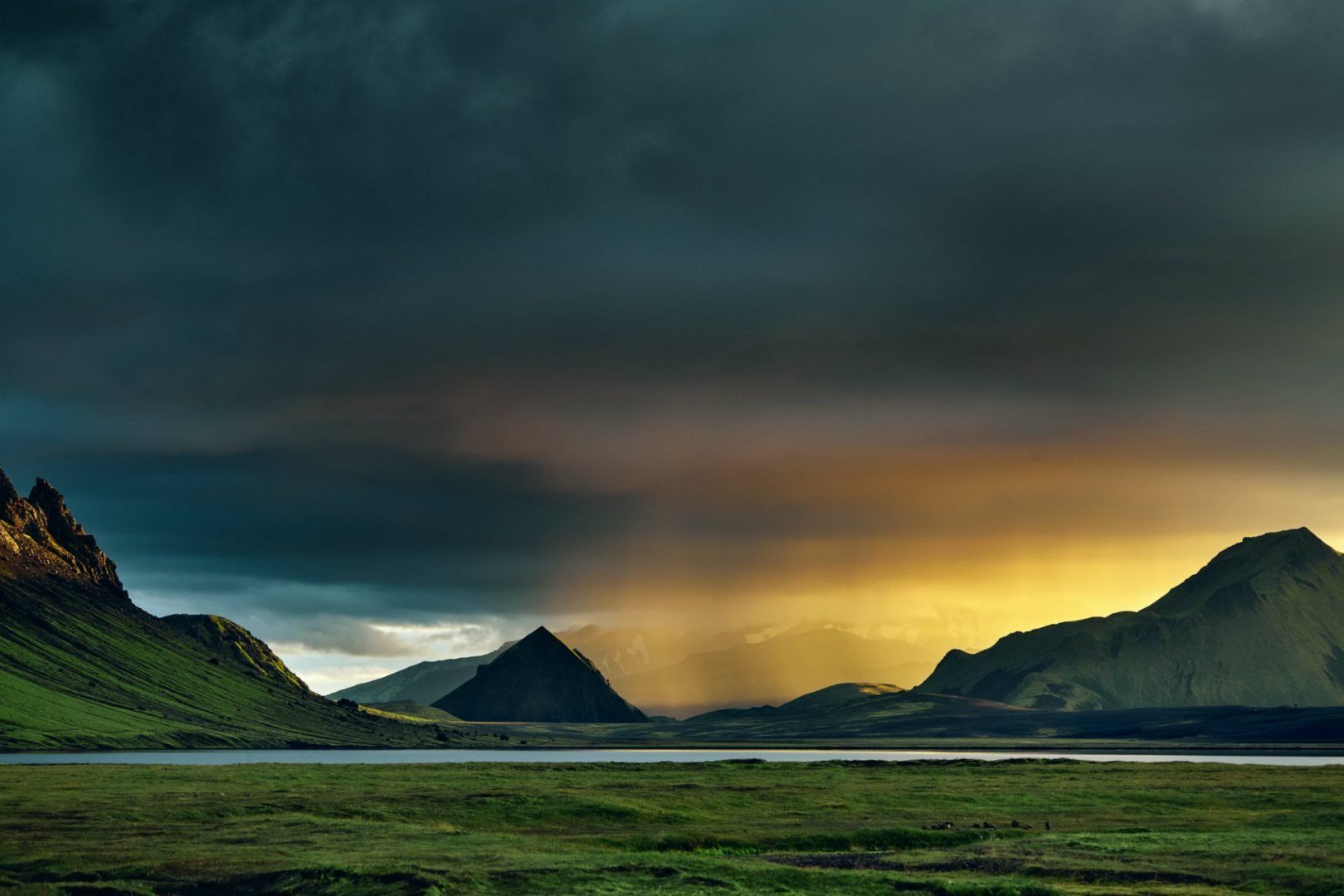
8. Sprengisandur Route (F26)

The Sprengisandur Route is one of the most remote drives you can do in Iceland. It’s a 125-mile (200 km) stretch across a vast desert between the Hofsjökull and Vatnajökull glaciers, with nothing but black sand, gravel plains, and big skies.

There’s almost no vegetation, no towns, and no phone service. You’re really on your own out here, which is part of the appeal if you want to get away from everything. It’s a route for people who are comfortable being completely off-grid for a while.

How to drive the Sprengisandur Route

This isn’t for beginners. You’ll need a high-clearance 4WD and experience driving on rough terrain. There are multiple river crossings—some of them can get deep, especially after rain—so you need to be able to assess them before crossing.

Bring enough food, fuel, and water for the whole trip, plus emergency supplies and ideally a satellite phone. It’s a good idea to travel with another vehicle and let someone know your planned route and expected return time. There are a couple of mountain huts along the way where you can ask about river conditions before continuing.

When to drive the the Sprengisandur Route

You’ve got a short window: early July to late August, depending on the year. The safest time to go is usually mid-July, once river levels have dropped after the snowmelt. Head out early in the day, since meltwater can raise the rivers by afternoon. Always check the forecast before you leave and talk to a ranger or local staff if you’re unsure—this route can close quickly if conditions change.
 

Vatnajokull National Park, Iceland

9. Highlands F208 (Fjallabak Nature Reserve)

F208 takes you through some of the most colorful and dramatic terrain in Iceland’s highlands. You’ll pass lava fields covered in moss, black volcanic deserts, and rhyolite mountains that shift in color depending on the light.

It’s about 70 miles (113 km) through the Fjallabak Nature Reserve, leading to Landmannalaugar, which is a popular area for hiking and hot spring bathing. The landscapes change constantly.

How to drive the Highlands F208

You need a proper 4WD with high clearance—this route has several river crossings, and they aren’t always shallow. The northern approach is more rugged and challenging than the southern one, so plan accordingly.

Take river crossings seriously—walk them if you’re unsure—and avoid driving off-track, since the moss is extremely fragile and takes decades to regrow.

When to drive the the Highlands F208

F208 usually opens around mid-June and stays accessible until early fall. July and August tend to be the most stable months. If you’re crossing rivers, go in the morning before the sun has melted more ice and raised the water level. By mid-August, you’ll start to see fall colors across the moss and grasses. 
 

landmannalaugar-fjallabak-iceland-shutterstock_1429552889

10. Snæfellsnes Peninsula

The Snæfellsnes Peninsula is a 90-mile (145 km) Iceland road trip that will cruise through a few landscapes in one manageable drive. You’ll see black sand beaches, lava fields, cliffs, small fishing villages, and the glacier that inspired Journey to the Center of the Earth.

It’s a nice option if you want variety without going deep into the highlands. Easy to do in a day from Reykjavík, though staying overnight is a bit nicer.

How to drive the Snæfellsnes Peninsula

The loop follows paved and well-graded gravel roads that are fine for most cars. Most people start in Borgarnes and drive clockwise for better views along the southern coast.

Route 54 is the main road, but a few detours are worth your time—like Arnarstapi and the beach near Búðir. Winds can get intense near the coast, especially in the south, so keep an eye on the forecast. Parking is available at most stops but can fill up quickly in summer.

When to drive the the Snæfellsnes Peninsula

This route stays accessible year-round. In summer, long days mean you can take your time. Winter brings snow-covered scenery and a shot at seeing the northern lights. Spring sees seabirds return to the cliffs around Arnarstapi and Hellnar. Fall usually has fewer people and a softer light.


Kirkjufell, Snaefellsnes peninsula, Iceland © Shutterstock

11. Reykjanes Peninsula

Just outside Keflavík Airport, the Reykjanes Peninsula is an easy way to get a feel for Iceland’s volcanic side. You’ll cross the Mid-Atlantic Ridge, pass steaming vents and geothermal plants, and maybe hike to some of the island’s newest lava from the 2021–2023 eruptions. It’s a good option for your first or last day—close to the airport, but still full of things to see.

How to drive the Reykjanes Peninsula

The main roads are paved and easy to follow. From the airport, take Route 41, then connect to Routes 43 and 427 to loop around. Leave time for geothermal stops and short hikes. Gunnuhver and Krýsuvík are popular, so use the designated parking and stay on marked paths.

When to drive the the Reykjanes Peninsula

You can drive this loop year-round. In winter, the coastline gets dramatic and you might see the northern lights from places like the lighthouse at Reykjanesviti. Summer is easier for hiking and has longer daylight hours. Spring and fall usually mean fewer people at busy areas like the Bridge Between Continents. If lava is flowing again, check official sources before you go to make sure it’s safe and accessible.
 

Seltun Iceland Reykjanes © Shutterstock

12. Kverkfjöll Route

The Kverkfjöll Route heads into Iceland’s northeastern highlands and ends at the edge of Vatnajökull glacier, where geothermal heat creates steaming vents and ice caves. You’ll drive across lava fields and through barren terrain before reaching a mix of ice and volcanic activity that’s hard to see anywhere else. It’s not a casual drive—this one’s for people who are prepared and looking for something remote.

How to drive the Kverkfjöll Route

You’ll need a high-clearance 4x4 and experience with river crossings. After heavy rain, some of the rivers can get deep and unsafe. This is a remote drive with no cell signal, so bring emergency gear, extra fuel, and a GPS. Most travelers go in pairs or groups in case something goes wrong. You’ll hike the last stretch of this Iceland road trip to get to the ice caves.

When to drive the the Kverkfjöll Route

This route is only accessible from mid-July through August, and even then, conditions can change fast. Rangers sometimes close it if rivers rise. Early August tends to be the most stable time, but always double-check before heading out. 
 

Famous glacier caves at Kverkfjoll in the highlands of Iceland used to be magical place to visit © Filip Fuxa/Shutterstock

13. Golden Circle

The Golden Circle is a well-known route that lets you see some of Iceland’s best-known natural sights in one loop, just under 190 miles (300 km) round trip from Reykjavík. You’ll pass Gullfoss, a powerful waterfall that drops into a narrow canyon, then head to the Geysir geothermal area where Strokkur shoots boiling water into the air every few minutes.

Þingvellir National Park is the third stop—this is where Iceland’s first parliament met back in 930 AD, and where you can walk between tectonic plates. This iconic Iceland road trip is an easy trip to fit into a single day.

How to drive the Golden Circle

The roads are fully paved, and any rental car will work fine. From Reykjavík, follow Route 36 to Þingvellir, then continue to Geysir using Routes 365 and 37. From there, head to Gullfoss and return on Route 35.

Going clockwise usually means fewer crowds early on. There’s parking at each main site, but they can get busy by late morning in summer. If you’ve got time, consider quick stops at places like Kerið crater or the Friðheimar tomato farm along the way.

When to drive the the Golden Circle

You can drive it year-round. In winter, the roads are cleared regularly, but you'll have fewer daylight hours. Summer has long days and better weather, though it’s busier—starting before 9am or after 5pm helps avoid the worst of the crowds. Spring and fall are a bit quieter, and September often has good light and fewer people.


Gullfoss waterfall, Iceland © Shutterstock

14. Egilsstaðir to Seyðisfjörður mountain drive

This short 17-mile (27 km) drive connects the inland town of Egilsstaðir with the fjord-side village of Seyðisfjörður. The road climbs through the mountains, passing lakes and waterfalls, before dropping down into the fjord surrounded by steep cliffs and colorful old buildings.

It’s a quick trip, but the scenery changes fast and dramatically—it’s especially memorable if you’re arriving by ferry from mainland Europe and this is your first look at Iceland’s landscape.

How to drive Egilsstaðir to Seyðisfjörður

The road is paved but has lots of curves and some steep grades. In summer, it’s fine for any car, but in winter you’ll want a 4WD and should be comfortable driving in snow.

Use pullouts for photos—don’t stop in the middle of the road. Fog can roll in quickly at higher elevations, so take your time and drive cautiously on the descent.

When to drive Egilsstaðir to Seyðisfjörður

Summer is the easiest time to drive this road and usually lines up with local events like the LungA arts festival in July. In fall, the trees and shrubs turn red and gold, which makes for great views. Spring brings runoff from the snowmelt, so the waterfalls are usually stronger.
 

iceland_road_trip.JPG

15. Kerlingarfjöll Route

This drive heads into Iceland’s central highlands and ends at Kerlingarfjöll, a geothermal mountain area filled with steaming vents, colorful hills, and hiking trails. It’s about 75 miles (120 km) from the Ring Road, and the route crosses wide, empty plains before climbing into the mountains.

The landscape around Kerlingarfjöll is strange and beautiful with rust-colored peaks with yellow sulfur streaks and boiling mud below. It’s a good option if you’re already comfortable driving F-roads and want to see something different without doing a longer highland trip.

How to drive the Kerlingarfjöll Route

You’ll need a 4WD vehicle with decent clearance. Take F35 (Kjölur) and then turn east onto F347 to reach the mountain area. Drive slowly—sections can be rough and the road gets steeper toward the end. There aren’t any gas stations nearby, so bring extra fuel.

The full round trip is over 150 miles (240 km), and there are no services on the way. Check road conditions before you go.

When to drive the Kerlingarfjöl Route

You can usually reach the area from mid-June to mid-September. Early summer still has snow in some areas, which makes for dramatic contrast with the red hills. Late August brings softer light and fewer people on the trails.


Dre Roelandt

written by
Dre Roelandt

updated 21.07.2025

Dre Roelandt is originally from the United States but lives and works in Berlin, Germany. Dre is a freelance writer and artist with a passion for travelling. They are an in-house Senior Content Editor at Rough Guides.

Planning your own trip? Prepare for your trip

Use Rough Guides' trusted partners for great rates