Planning your own trip? Prepare for your trip
Use Rough Guides' trusted partners for great rates
written by
Rough Guides Editors
The name Golden Circle might be a tourist-industry tag, but it’s also apt, as this broad circuit east from Reykjavík covers many of Iceland’s best-known features and touches on the root of much of its history. The key area is Þingvellir, whose dramatic and geologically unstable rift valley marks the place where the Icelandic state sprang into being in Viking times. South from here is the religious centre of Skálholt, where Iceland’s last Catholic bishop was assassinated in 1550; travelling northeast takes you past the spa town of Laugarvatn to Geysir, the original hot blowhole that has lent its name to similar vents worldwide, before sealed roads end on the edge of Iceland’s barren interior at Gullfoss’ thundering twin cataracts.
The tangle of routes connecting all this together runs through the beautiful countryside: fertile, flat, framed by distant hills and startlingly green in summer, thanks to one of Iceland’s longest rivers, the Hvítá. This originates around 140km northeast at Hvítarvatn, an isolated lake below Langjökull on the Kjölur route, and flows swiftly to Gullfoss, where it drops into the plains above Skálholt before running south to the sea.
Wild and romantic though the region is, don’t expect to appreciate it in solitude: most of the sights suffer year-round visitor overload, with tour buses clogging car parks until well into the evening.
Þingvellir has the official UNESCO World Heritage Site due to its unique geology in which two tectonic plates meet, the North American plate and the Eurasian. Slowly pulling apart a few centimetres per year, the plates are the main reason for Iceland's volcanoes and spectacular landscapes. For a truly surreal experience, diving between the plates in Silfra is possible.
You can make an easy, satisfying 10km circuit of Þingvellir and the rift valley along marked trails in under three hours. Starting at the National Park Information Centre, walk a short way east along the road past the campsite until you see a marker for the 2km footpath to Hrauntún through a landscape of mossy rocks, lava pavements and dwarf birch scrub. Hrauntún is the site of an abandoned farm, still ringed by a lava-block wall. There isn’t a single tree on the site – clearing them all must have taken some effort.
Turn south and follow a well-used 3km track to Skógarkot, a sheep farm abandoned in the 1930s, whose ruined but strongly constructed stone buildings occupy a grassy hillock roughly halfway across the valley. It’s not a high position, but still elevated enough for you to take in a panorama of distant peaks and rift walls, and feel dwarfed by the scale of the Þingvallahraun lava flow which stretches all the way from the lake to Skalbreiður. From here bear west towards the church at Þingvellir – a further 2km along a decent trail – and then follow Almannagjá for a final 3km back to your starting point.
With laws shall our land be built up, but with lawlessness laid waste.
Njál’s Saga
By the beginning of the tenth century, Iceland’s 36 regional chieftains recognized the need for some form of national government. Rejecting the idea of a paramount ruler, Norwegian law was adapted and the first Alþing, or General Assembly, was held in the rift valley north of Þingvallavatn in 930 AD, at a place which became known as Þingvellir, the Assembly Plains. Though the Alþing’s power declined through the ages, Þingvellir remained the seat of Iceland’s government for the next eight centuries.
The Alþing was held for two weeks every summer, and attendance for chieftains was mandatory. In fact, almost everyone who could attend did so, setting up their tented camps – buðs – and coming to watch the courts in action or settle disputes, pick up on gossip, trade, compete at sports and generally socialize. The whole event was coordinated by the lawspeaker, while the laws themselves were legislated by the Law Council, and dispensed at four regional courts, along with a fifth supreme court. Strangely, however, none of these authorities had the power to enforce their verdicts, beyond bringing pressure to bear through public opinion. The adoption of Christianity as Iceland’s official religion in 1000 AD was one of the Alþing’s major successes, but if litigants refused to accept a court’s decision, they had to seek satisfaction privately. Njál’s Saga contains a vivid account of one such event, when a battle between two feuding clans and their allies broke out at the Alþing itself around 1011 AD; while Hrafnkel’s Saga shows how people manipulated processes at the Alþing and could, if they wanted, ignore court verdicts.
This lack of real authority undermined the Alþing, creating a power vacuum in Iceland that ultimately saw Norway and then Denmark assume control of the country. By the late thirteenth century the Alþing was losing its importance, with the lawspeaker’s position abolished and the courts stripped of all legislative power. Eventually, while still meeting for a few days every year, the Alþing became a minor affair, and the last assembly was held at Þingvellir in 1798, replaced by a national court and parliament at Reykjavík.
During the mid-nineteenth century Þingvellir became the focus of the nationalist movement, with large crowds witnessing various independence debates here – the Danish king even attended Iceland’s millennial celebrations at Þingvellir in 1874. The site remained a symbol of national identity through the twentieth century, peaking when half the country turned up at Þingvellir to hear the declaration of independence from Denmark and the formation of the Icelandic Republic on June 17, 1944.
Located in Haukadalur Valley are a series of hot springs and geysers that promise a spectacle of nature. Strokkur, the stronger geyser shoots an impressive jet of boiling water 20 metres into the air every 5 - 10 minutes and is arguably the most iconic geyser in the world.
Travellers typically spend around 40 minutes around the Geysir area. Strokkur, the most famous Geysir erupts every 5 - 10 minutes and once this has been witnessed there are other equally spectacular sights on the route that has keen spectators eager to see. If you wish to stay longer and take a short walk to stretch your legs, we've got you covered.
From the hot springs area, well-worn tracks lead to the summit of Bjarnarfell (727m) for views down on Geysir’s surrounds.
Another option is to follow the signposted 3km gravel vehicle track from Geysir up to a forestry reserve and church at Haukadalur. In saga times Haukadalur was an important holding, another famous educational centre that was eventually incorporated into Skálholt’s lands. Extensive felling and ensuing erosion put paid to the estate, which was in a sorry condition when turned into a reserve in the 1930s. Since then, the hillsides here have been planted thickly with green pine trees, and thousands of new saplings spread down the valley. Have a quick look at the nineteenth-century church, too, whose brass door-ring is said to have belonged to the friendly giant Bergþór, who asked to be buried here.
Found in the Hvítá river canyon is the incredible Gullfoss waterfall. In a dramatic display, water pounds down 32 meters and roars with sound.
Gullfoss still exists only because Sigríður Tómasdóttir, daughter of the owner of the estate that incorporated the falls, fought first her father and then the government to prevent a hydroelectric dam being built here in the 1920s. Permission to build the dam was granted, but public feeling – fanned by Sigríður – ran so strongly against the project that construction never began. Gullfoss was donated to the Icelandic Nature Conservation Council, and the area became a protected reserve in 1979.
For more than one person, the cheapest way to cover the Golden Circle is to rent a car for the day. From Reykjavík, take Route 36 northeast to Þingvellir (watch out for ice in winter), then continue east along the 365 to Laugarvatn, from where routes 37 & 35 run up to Geysir and Gullfoss. On the way back, follow Route 35 southwest to Selfoss, detouring briefly along the way to visit Skálholt and Kerið crater. Selfoss itself is on the Ringroad 30km east of Reykjavík).
Without your own vehicle, you can pack all this into a nine-hour Golden Circle tour offered by Reykjavík Excursions, Grayline and Sterna. All can collect from Reykjavík accommodation and a guide provides commentary in English en route.
Slightly cheaper are Reykjavík Excursions’ daily Þingvellir–Laugarvatn–Geysir–Gullfoss scheduled buses from the BSÍ terminal in Reykjavik, which stop long enough at all the sights for you to get a good look; you can, of course, arrange to spread this trip over several days and stay overnight at places along the way. Be aware too that summer buses heading to Akureyri via Kjölur travel the same route (though most skip Þingvellir), so you might not need to make a separate trip to see the Golden Circle.
Tip from Rough Guides: also learn about the best ways to get to Iceland.
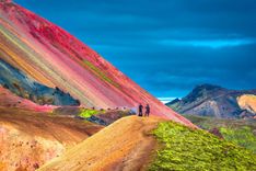
Featured Image, Golden Circle Highway © Bgwalker / iStock
Use Rough Guides' trusted partners for great rates
written by
Rough Guides Editors


.jpg)