The Trang and Satun islands
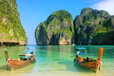
Generally blessed with blinding white beaches, great coral and amazing marine life, the islands off the coast of Trang and Satun provinces have managed, mostly with just a handful of resorts on each, to cling onto some of that illusory desert-island atmosphere which better-known places like Phuket and Samui lost long ago. Indeed, islands such as Ko Hai and Ko Kradan support no permanent settlements other than the bungalow concerns, while on Ko Tarutao and Ko Adang in the far south, the peace and quiet is maintained by the national parks department; at the other end of the scale, however, nearby Ko Lipe is developing at its own merry pace and now boasts over forty resorts, as well as a substantial chao ley village.
Ko Hai (Ko Ngai)
KO HAI (also known as KO NGAI), 16km southwest of Pak Meng, is the most developed of the Trang islands, though it’s still decidedly low-key. The island’s action, such as it is, centres on the east coast, where half a dozen resorts enjoy a dreamy panorama of jagged limestone outcrops, whose crags glow pink and blue against the setting sun, stretching across the sea to the mainland behind. The gently sloping beach of fine, white sand here runs unbroken for over 2km (though at low tide, swimming is not so good at the northern end, which is scattered with dead coral), and there’s some good snorkelling in the shallow, clear water off the island’s southeastern tip.
Ko Hai activities
You can rent snorkelling equipment (B100/day at Coco Cottage, for example) and kayaks (B50/hr at Koh Ngai Villa, for example) at most of the resorts. All the resorts offer boat trips (B1500/boat, or B300/person in a group of six, at Ko Hai Seafood, for example) that take in the Emerald Cave on Ko Mook and some snorkelling off Ko Hai. (Ko Cheuak, just to the southeast of Ko Hai, is currently off-limits to visitors to protect the coral, which was badly bleached during a sudden rise in sea temperatures in 2010 – avoid any place that offers trips there.) Ko Hai Seafood can also put together overnight snorkelling and camping trips to Ko Rok for B2300 per person.
Towards the southern end of the beach, Fantasy Resort has a well-organized dive shop, the German-run Rainbow Divers.
Ko Mook
KO MOOK, about 8km southeast of Ko Hai, supports a comparatively busy fishing village on its eastern side, around which – apart from the sandbar that runs out to the very pricey Sivalai Resort – most of the beaches are disappointing, reduced to dirty mud flats when the tide goes out. However, across on the island’s west coast lies beautiful Hat Farang, with gently shelving white sand, crystal-clear water that’s good for swimming and snorkelling, and gorgeous sunsets.
Tham Morakhot
The island’s main source of renown is Tham Morakhot, the stunning “Emerald Cave” north of Hat Farang on the west coast, which can only be visited by boat, but shouldn’t be missed. An 80m swim through the cave – 10m or so of which is in pitch darkness – brings you to a hong with an inland beach of powdery sand open to the sky, at the base of a spectacular natural chimney whose walls are coated with dripping vegetation. Chartering your own longtail or taking a trip with Ko Mook Nature Beach Resort (B200/person, in a group of four or more) is preferable to taking one of the big day-trip boats that originate on Lanta or Pak Meng: if you time it right, you’ll get the inland beach all to yourself, an experience not to be forgotten. It’s also easy enough to kayak there from Hat Farang (from B100/hr from Sawaddee), and at low tide you can paddle right through to the inland beach: buoys mark the cave entrance, from where a tunnel heads straight back into the rock; about halfway along, there’s a small, right-hand kink in the tunnel which will plunge you briefly into darkness, but you should soon be able to see light ahead from the hong. Mid-afternoon is often a good time to paddle off on this trip, after the tour boats have left and providing the tide is right.
Getting to Ko Mook
In addition to the services mentioned below, there are plenty of island-hopping options.
Accommodation in Ko Mook
Most of Hat Farang is unfortunately occupied by the disappointing Charlie’s Resort, leaving room only for one other resort, Sawaddee. However, Rubber Tree and Had Farang make the best of the attractive, shady slopes behind the beach, while Ko Mook Nature Beach Resort is away on the east side of the island near the village.
Ko Kradan
About 6km to the southwest of Ko Mook, KO KRADAN is the remotest of the inhabited islands off Trang, and one of the most beautiful, with crystal-clear waters. On this slender triangle of thick jungle, the main beach is a long strand of steeply sloping, powdery sand on the east coast, with fine views of Ko Mook, Ko Libong and the karst-strewn mainland, and an offshore reef to the north with a great variety of hard coral; such beauty, however, has not escaped the attention of the day-trip boats from Ko Lanta, who turn the beach into a lunchtime picnic ground most days in summer. From a short way north of the Anantara beach club, which is located towards the south end of this beach, a path across the island will bring you after about fifteen minutes to Sunset Beach, another lovely stretch of fine, white sand in a cove; a branch off this path at Paradise Lost leads to a beach on the short south coast, which enjoys good reef snorkelling (also about 15min from the Anantara beach club).
Ko Libong
The largest of the Trang islands with a population of six thousand, KO LIBONG lies 10km southeast of Ko Mook, opposite Ban Chao Mai on the mainland. Less visited than its northern neighbours, it’s known mostly for its wildlife, although it has its fair share of golden beaches too. Libong is one of the most significant remaining refuges in Thailand of the dugong, a large marine mammal similar to the manatee, which feeds on sea grasses growing on the sea floor – the sea-grass meadow around Libong is reckoned to be the largest in Southeast Asia. Sadly, dugongs are now an endangered species, traditionally hunted for their blubber (used as fuel) and meat, and increasingly affected by fishing practices such as scooping, and by coastal pollution, which destroys their source of food. The dugong has now been adopted as one of fifteen “reserved animals” of Thailand and is the official mascot of Trang province.
Libong is also well known for its migratory birds, which stop off here on their way south from Siberia, drawn by the island’s food-rich mud flats (now protected by the Libong Archipelago Sanctuary, which covers the eastern third of the island). For those seriously interested in ornithology, the best time to come is during March and April, when you can expect to see brown-winged kingfishers, masked finfoots and even the rare black-necked stork, not seen elsewhere on the Thai–Malay peninsula.
The island’s handful of resorts occupy a long, thin strip of golden sand at the fishing village of Ban Lan Khao on the southwestern coast. At low tide here, the sea retreats for hundreds of metres, exposing rock pools that are great for splashing about in but not so good for a dip.
Ko Libong boat trips and diving
Libong Nature Beach Resort runs award-winning, day-long boat trips around Libong (B1200/person, including lunch, in a group of four or more; ten percent discount for guests), which are safe, insured and licensed with TAT, and staffed by local chao ley (sea gypsies) who know the dugong well. As well as visiting a chao ley village, these give you the chance to kayak into the sanctuary to observe the rare birds and to snorkel at the sea-grass beds – with, they reckon, an eighty percent chance of seeing a dugong. They also run day-trips to the Emerald Cave on Ko Mook and Ko Kradan (B1200/person, including lunch, in a group of four or more; ten percent discount for guests). If you’d rather explore below water than above, there’s a PADI dive shop, Jolly Roger, at Libong Beach Resort on the north side of Ban Lan Khao.
Ko Sukorn
A good way south of the other Trang islands, low-lying KO SUKORN lacks the white-sand beaches and beautiful coral of its neighbours, but makes up for it with its friendly inhabitants, a laidback ambience and one excellent resort; for a glimpse of how islanders live and work, this is the place to come.
The lush interior is mainly given over to rubber plantations, interspersed with rice paddies, banana and coconut palms; the island also produces famously delicious watermelons, which are plentiful in March and April. Hat Talo Yai, the main beach – 500m of gently shelving brown sand, backed by coconut palms – runs along the southwestern shore.
Ko Sukorn boat trips and other activities
Boat excursions from Sukorn Beach Bungalows include trips out to the islands of Ko Lao Liang and Ko Takieng, which are part of the Mu Ko Phetra National Marine Park, for some excellent snorkelling. These run nearly every day from November to May; at other times of year, the sea is sometimes calm enough but you’re usually restricted to fishing trips – and to looking round the island itself, which, at thirty square kilometres, is a good size for exploring. The resort offers guided tours, and has motorbikes (B250/half-day) and mountain bikes (B150/ half-day) for rent, as well as a handy map that marks all the sights, including the three villages and seafood market.
Ko Tarutao National Marine Park
The unspoilt KO TARUTAO NATIONAL MARINE PARK is probably the most beautiful of all Thailand’s accessible beach destinations. Occupying 1400 square kilometres of the Andaman Sea in Satun province, the park covers 51 mostly uninhabited islands. Site of the park headquarters, the main island, Ko Tarutao, offers a variety of government-issue accommodation and things to do, while Ko Adang to the west is much more low-key and a springboard to some excellent snorkelling. The port of Pak Bara is the main jumping-off point for the park, and houses a national park visitor centre, set back on the left just before the pier, where you can gather information and book a room on Tarutao or Adang before boarding your boat.
The park’s forests and seas support an incredible variety of fauna: langurs, crab-eating macaques and wild pigs are common on the islands, which also shelter several unique subspecies of squirrel, tree shrew and lesser mouse deer; among the hundred-plus bird species found here, reef egrets and hornbills are regularly seen, while white-bellied sea eagles, frigate birds and pied imperial pigeons are more rarely encountered; and the park is the habitat of about 25 percent of the world’s tropical fish species, as well as dugongs, sperm whales, dolphins and a dwindling population of turtles.
The park amenities on Adang, though not on Tarutao, are officially closed to tourists in the monsoon season from mid-May to mid-November (the exact dates vary from year to year). Accommodation is especially likely to get full around the three New Years (Thai, Chinese and Western), when it’s best to book national park rooms in advance.
Island-hopping and tours
Access to the Trang and Satun islands from their nearest mainland ports is described in the individual island accounts, but what sets this area apart are the enticing opportunities for island-hopping, thanks to regular boat services in the tourist season out of Ko Lanta, further up the coast, which can be booked through any travel agent in the area. If you just fancy a day exploring some of the islands, any travel agent in Trang can book you on a boat trip (mid-Oct to mid-May only) to Ko Kradan, the Emerald Cave on Ko Mook, and other small nearby islands for snorkelling, for around B700/person including packed lunch and soft drinks.
Satun town
Nestling in the last wedge of Thailand’s west coast, the remote town of SATUN is served by just one road, Highway 406, which approaches through forbidding karst outcrops. Set in a green valley bordered by limestone hills, the town is leafy and relaxing but not especially interesting, except during its small version of the Vegetarian Festival and its International Kite Festival at the end of February; the boat services to and from Kuala Perlis and Langkawi in Malaysia and Ko Lipe are the main reason for foreigners to come here.
Crossing into Malaysia from Satun
From Thammalang pier, 10km south of Satun at the mouth of the river, boats leave when full on 45-minute trips (B150/person) to Kuala Perlis on the northwest tip of Malaysia, from where there are plentiful transport connections down the west coast; 9am is usually a good time to turn up at Thammalang for these boats, but they need a minimum of ten passengers (or B1500), which means that on some days they don’t run. Three ferry boats a day cross from Thammalang to the Malaysian island of Langkawi (1hr 15min; B300). The journey from Satun town to Thammalang is covered by orange songthaews (roughly every 30min; B40) from near the 7-Eleven supermarket on Thanon Sulakanukul, as well as chartered tuk-tuks (B150) and motorcycle taxis (B60–70).
It’s also possible to cross by road to Malaysia’s Kangar (which has bus connections to Penang and Kuala Lumpur) and Alor Setar through Thale Ban National Park, though a little tricky as the a/c minibuses (B300; about 2hr) depart from Ban Khuan, 20km or so up Highway 406 from Satun – contact local fixer On Kongnual, who owns the restaurant On's: The Kitchen, near the Sinkiat Thani Hotel, to arrange this.
Ko Lipe
Home to a population of around a thousand chao ley, tiny KO LIPE, 2km south of Ko Adang, is something of a frontier maverick, attracting ever more travellers with one dazzling beach, fifty or so private bungalow resorts and a rough-and-ready atmosphere. It’s technically a part of Ko Tarutao National Marine Park, but the authorities seem to have given up on the island and don’t collect an admission fee from visitors. A small, flat triangle, Lipe is covered in coconut plantations and supports a school and a health centre in the village on the eastern side. By rights, such a settlement should never have been allowed to develop within the national park boundaries, but the chao ley on Lipe are well entrenched: Satun’s governor forced the community to move here from Phuket and Ko Lanta between the world wars, to reinforce the island’s Thai character and prevent the British rulers of Malaya from laying claim to it.
Snorkelling and diving around Ko Lipe
The prime diving and snorkelling sites around Ko Lipe are around Ko Adang, Ko Rawi and Ko Dong, just to the north and west in Ko Tarutao National Marine Park, where encounters with reef and even whale sharks, dolphins and stingrays are not uncommon. Further afield to the south, advanced divers head for Eight Mile Rock, a pinnacle that rises to about 14m from the surface, with soft corals, mantas, leopard and whale sharks. A handful of dive shops operate on Lipe, and there are dozens of places offering snorkelling day-trips on chao ley longtail boats; snorkellers are liable to pay the park admission fee of B200, though some longtail captains will try to dodge the park rangers.
Thinking of travelling to Thailand? Start planning by learning about how to get to Thailand.