Remote and restricted areas
Treks in remote far eastern and far western Nepal are mostly restricted to two kinds of traveller, both adventurous in their own way. The majority come on organized camping treks with agencies – in fact, this is obligatory for those areas that require a permit. The minority are independent trekkers prepared either to carry tents and food and negotiate with porters, or to seek food and lodging in local homes and basic lodges. Independent travel is difficult in the west, where food shortages, relatively low population and cultural barriers can be problematic. Access is a problem on both sides of the country. In the east, Basantapur, the principal trailhead, is some 24 hours by bus from Kathmandu. Journey times to the far west by road – where there are roads – don’t even bear calculating. Flights, therefore, are worth looking into. Few cost little more than $100 one-way, though some remote areas require two flights to reach.
Far eastern Nepal
Ethnically, EASTERN NEPAL is even more diverse than the Annapurna region: Rais and Limbus are dominant in the hills, while Sherpas, Tamangs and other highlanders inhabit the high country, and Hindu castes the valleys. Makalu, Kanchenjunga and other big peaks provide stunning views from most high points. Flora and fauna are also of great interest to specialists, especially the butterflies and other insects of the upper Arun Valley, and the rhododendrons of the Milke Daada. The east is relatively well-off, so in the settled areas, especially in the region around the Newari bazaar towns of Bhojpur, Chainpur and Khandbari, food and lodging is easy to come by – making fine country for adventurous trekkers who like exploring places that aren’t written up in guidebooks. The serious mountain treks to Makalu and Kanchenjunga, however, require expedition-scale planning, official permits and agency support.
The Milke Daada
A long north–south ridge famed for its spectacular views and rhododendrons, the MILKE DAADA can be linked up with a visit to the bazaar town of Chainpur for a fine trek of seven or so days, going no higher than 3500m. From Basantapur the route heads north, initially following a rough road then continuing north on paths through the lush cloud forest of the Milke Daada, past the lakes at Gupha Pokhari (2890m). Various trails to Chainpur branch off to the west; from there you can hitch a jeep ride to the airstrip at Tumlingtar or return to Hile. Alternatively, you could head east from Gupha Pokhari to Taplejung airstrip. Both Tumlingtar and Taplejung airstrips have more frequent and reliable connections to Biratnagar, in the Eastern Terai, than to Kathmandu.
Basic food and lodging can be found along most of this route, but the absence of lodges north of Gupha Pokhari limits an independent trekker’s ability to explore higher up the Milke Daada.
Makalu Base Camp
Much of the MAKALU BASE CAMP trek passes through the wild and remote Makalu-Barun National Park and the contiguous Makalu-Barun Conservation Area. Established in 1992, the park is intended to stem the growing human pressure around the base-camp area and preserve one of the most botanically diverse and wildlife-rich areas in the Himalayas. The usual starting point is the airstrip at Tumlingtar, though a marathon road trip could get you there (and even beyond, up to Khandbari) via Dharan, Hile and Basantapur. There are alternative routes on either side of the Arun for the first three or four days, but only one route above there for the next seven days or so (for which a tent and food are required) to the base camp, so you’re obliged to retrace your steps most of the way back. The highest days take you over the Barun also known as the Shipton La (4127m), and into the remote Upper Barun valley, whose lofty beauty is often compared to the Annapurna Sanctuary.
Kanchenjunga
The most incredible trek in this part of Nepal is to the foot of KANCHENJUNGA, the third-highest peak in the world at 8586m, and arguably the most romantic. Kanchenjunga is an expensive trek because it’s officially restricted to agency-organized groups and, given its remote location in the extreme northeastern corner of the country, it involves up to three weeks’ walking, or more if you plan to visit both south and north sides. Unofficially, it may be possible to do this trek independently, with an agency organizing your permit, and porters carrying your supplies for the upper elevations – there are basic bhattis to stay and eat in lower down. There’s a Rs1000 fee to enter the Kanchenjunga Conservation Area.
The starting points are either the roadhead at Basantapur, initially following the trail up the Milke Daada, or, saving three days, the airstrip at Taplejung – which has occasional direct flights from Kathmandu but is more efficiently served via Biratnagar, in the Eastern Terai.
The trek passes deep into Limbu country, forking a few days northeast of Taplejung, one trail going to the snowy and fabulously scenic North Base Camp at glacier-strewn Pangpema, the other rollicking up and down on the way to the South Base Camp and the Yalung Glacier. (The high passes connecting the two are distinctly tricky propositions, and not to be considered without experienced guides.) Both routes offer terraced hills, wildlife-rich forests and a serious taste of unspoiled Nepali hill culture, along with fabulous views. The northern trail takes you deeper into the high mountains for longer – up to a week longer, with all the problems and risks that entails.
Far western Nepal
West of Dhaulagiri, the Himalayas retreat north into Tibet, while the foothill zone broadens, the climate becomes drier and the people poorer. The northern third of the region, left in the rain shadow of the Himalayas, receives little monsoon moisture – in every way but politically, this highland strip is part of Tibet. Jagged Himalayan grandeur isn’t so much in evidence, but there’s a wildness and a vastness here, and the feeling of isolation is thrilling. Treks in the FAR WEST are well off the beaten track: they’re a chore to get to, they require a lot of preparation and, with the exception of Rara Lake, you’ll find that very few Westerners have gone before you. All that might appeal if you’re an experienced trekker looking for new challenges, but if you’re a first-timer without agency support, forget it. That said, as roads gradually penetrate into the far west, trekking is becoming easier.
Logistics make or break a trek in the far west. Given the distances involved, you’ll probably want to fly to the starting point, but the usual problems of confirming bookings are generally worse in this area. Food and lodging are in uncomfortably short supply, so you’ll need to bring a tent, cooking utensils and at least some provisions. You should be prepared to carry it all yourself, because porters here are a fickle lot and often can’t be spared from their farmwork. Guides familiar with the area are also scarce, so don’t venture out without a reasonable command of Nepali. If you go on an organized trek you may not be entirely insulated from these inconveniences, and for this reason agencies may try to steer you towards more easterly destinations.
The treks described below are the most realistic possibilities.
Rara National Park
RARA NATIONAL PARK is the best known of the far western trekking areas. The usual itinerary is a loop that starts and ends at Jumla airstrip, three to four days’ walk from the lake; most tours take about eight days for the trip. The country is a sea of choppy, mostly forested mountains, offering only glimpses of Himalayan peaks, but the highlight is Nepal’s largest lake, a lofty blue jewel surrounded by a wilderness area of meadows and forests of blue pine and rhododendron.
To get to the trailhead you first have to fly to Nepalgunj and then from there to Jumla; flights are supposed to be daily in season, but are often cancelled. There is also an airstrip at Talcha, less than three hours from the lake beside Gumgarhi, the remote capital of Mugu district, but flights up from Nepalgunj are irregular and most people choose to walk from Jumla. The overland alternative is to head up from Birendra Nagar (Surkhet) towards Jumla, which is either a week to ten days’ walk each way or a horrendously, unpredictably long bus journey – 48 hours isn’t unrealistic – on the grandiously named Karnali Highway, via Dailekh, Kalikot and Sinja, where the ruins of the capital of the twelfth- to fourteenth-century Khasa dynasty can be viewed across the river. There are lodges in Jumla and a bunkhouse at the lake; in between, there are a few teahouses where you might be able to stay, but camping is more pleasant and certainly more reliable – especially as food can be in short supply.
Technical difficulties aside, Rara makes a fair compromise between the popular treks and the really obscure ones, and in a way combines the best of both worlds: like the popular treks, Rara is given detailed route descriptions in the trekking books, so you can do it without an organized group or even a guide, yet it’s remote enough to ensure that you’ll see few – if any – other foreigners. Starting at the airstrip at Jumla (2400m), the route crosses two 3500m ridges before reaching pristine Rara Lake at 3000m. The park is one of the best places in Nepal to see wildlife, including Himalayan black bear, tahr, goral, musk deer and the rare red (lesser) panda; the lake itself is home to many species of waterfowl. Autumn and spring are the best seasons, and Rara is particularly worth considering in May and June, when the weather elsewhere is getting too hot or unpredictable.
Dolpo and She-Phoksundo National Park
DOLPO (sometimes written Dolpa) is an enormous, isolated district northwest of Dhaulagiri and bordering Tibet, the western half of which has been set aside as SHE-PHOKSUNDO NATIONAL PARK, Nepal’s biggest. The park protects an awe-inspiring region of deep valleys, unclimbed peaks, remote monasteries and rare fauna. The best time to go is September, with May, June, October and November close behind.
Dolpo was the setting of Peter Matthiessen’s The Snow Leopard, and for many years the book was as close as most foreigners were allowed to get to it. It’s now open to trekking, but only by organized groups. Unofficially, it might be possible to arrange a trekking permit for Southern (Lower) Dolpo through an agency and do everything else independently. The permit costs $10 per week, and a trek there will take a week to ten days. There are some lodges in Lower Dolpo, but it’s a food-deficit area so you’ll need to bring several days’ worth of provisions. Guides and porters can be hired near the airstrip. The agency-trekking requirement for Northern (Upper) Dolpo is strictly enforced, and the permit is much more expensive.
Most people fly into Juphal, the airstrip for Dolpo District, from Nepalgunj. Flying into or out of Jumla, about five days’ walk further west, is also possible. From Juphal the route heads east to Dunai and then north, entering the park after about a day (Rs1000 entry fee) and reaching the village of Ringmo and the stunningly blue Phoksundo Tal after another two days. There are plenty of day-hiking opportunities around the lake. Beyond lies Northern Dolpo.
Humla and Mount Kailash
Tucked away in the extreme northwestern corner of Nepal, HUMLA is high, dry and strongly Tibetan. Snowcapped peaks hem the district in on three sides and shut out most outside influences, including the monsoon. It’s open only to organized groups. This area often experiences serious spring and early-summer famines, so it’s essential to bring all the food you’ll need – and then some. Most people do Mount Kailash as part of a Tibet package: you might pay $4000 per person for a 22-day itinerary which takes you on to Lhasa, with a flight back to Kathmandu; or around $3400 for an 18-day trip returning on a jeep via Kodari.
Nepal Airlines flies from Nepalgunj to Simikot (Humla’s district headquarters) most days of the week in season. The most popular trek from here heads west up the valley of the Humla Karnali Nadi, struggling over the 4580m Nara La before descending to the river again and the Tibet border at Hilsa; it’s about six or seven days’ walk. From Sher, on the Tibetan side, a jeep will take you to (and, if need be, right around) Lake Manasarowar and the starting point for the three-day-plus circumambulation on foot of sacred MOUNT KAILASH. (The Humla Karnali trail is in the long process of being turned into a road, which will one day make it possible to drive the entire way from Simikot; those who prefer to walk will still be able to take a high, northerly route via Talung Lake to the border.) In May and June, which is the best time to go, the wildflowers are out of this world.
Upper Mustang
UPPER MUSTANG, the high-desert headwaters of the Thak Khola, was closed to foreigners until 1992, and still retains much of its medieval Tibetan culture – even if its raja has now officially been deposed and Chinese goods are now pouring across the border via a new road (the border is closed to foreigners). Permits to trek in Upper Mustang are expensive, but are no longer issued only to agency-organized groups, though you will need to take a guide. It is now possible to stay in lodges – often gloriously traditional family homes – rather than have to camp.
The restricted area officially begins at Kagbeni, and most visitors fly in and out of Jomosom, just a half-day’s walk to the south. From there up the high, desertified valley of the Thak Khola to Lo Manthang (3840m), the lofty, walled capital, it’s about five days’ walk, past wind-eroded cliffs in astonishing shades of sand, rust and grey. There’s little traffic on the road, but it’s bound to increase, so consider alternative routes avoiding the road, such as hiking southwest out of Lo Manthang, for instance, via the Chogo La and Ghar Gompa to rejoin the main trail at Ghemi.
The Annapurna region
The ANNAPURNA REGION’s popularity is well deserved: nowhere else do you get such a varied feast of scenery and hill culture and the logistics are relatively simple. Treks can all start or finish close to Pokhara, which is a relaxing place to end a trek and a handy place to start one, with its clued-up guesthouses, equipment-rental shops and easy transportation to trailheads. With great views just two days up the trail, short treks in the Annapurnas are particularly feasible, and good communications mean the region is also fairly safe, from the point of view of medical emergencies. Tourism is relatively sustainable, too, thanks to ACAP, the Annapurna Conservation Area Project. The inevitable consequence is commercialization. The popular treks in this region are on a well-beaten track, and unless you step aside from them you’re more likely to be ordering bottled beer from a laminated menu than drinking homebrew with locals.
The Annapurna Himal faces Pokhara like an icy, crenellated wall, 40km across, with nine peaks over 7000m spurring from its ramparts and Annapurna I reigning above them all at 8091m. It’s a region of stunning diversity, ranging from the sodden bamboo forests of the southern slopes (Lumle, northwest of Pokhara, is the wettest village in Nepal) to windswept desert (Jomosom, in the northern rain shadow, is the driest).
The himal and adjacent hill areas are protected within the Annapurna Conservation Area Project (ACAP). A quasi-park administered by a non-governmental trust, ACAP aims are to protect the area’s natural and cultural heritage and ensure sustainable benefit for local people. To take the pressure off local forests, the project has set up kerosene depots and installed microhydroelectric generators, and supports reforestation efforts. Lodge owners benefit from training and low-interest loans, enabling them to invest in things like solar water heaters and efficient stoves. Safe drinking-water stations (bottled water is banned), rubbish pits, latrines, health posts and a telephone service have all been established on the proceeds of park entry fees. ACAP also sets fixed lodge prices, and agrees menu prices (which vary by area), to prevent undercutting and price wars; these prices should be respected rather than negotiated – though the system does seem to be breaking down, and lodge owners get around it by putting “special items” on their menus.
The Annapurna Sanctuary
The ANNAPURNA SANCTUARY is the most intensely scenic short trek in Nepal, and one of the most well-trodden – there are lodges and tea stops at hourly intervals or less, until the highest sections at least. The trail takes you into the very heart of the Annapurna range, passing through huge hills in Gurung country with ever-improving views of the mountains ahead, then following the short, steep Modi Khola, before you pass into the most magnificent mountain cirque: the Sanctuary. Wherever you stand, the 360-degree views are unspeakably beautiful, and although clouds roll in early, the curtain often parts at sunset to reveal radiant, molten peaks.
The Sanctuary is usually an eight- to twelve-day round trip from Pokhara. The actual distance covered isn’t great, but altitude, weather and trail conditions all tend to slow you down. The trail gains more than 2000m from Ghandruk to the top, at 4100m, so you’d be wise to spread the climb over three or four days – and dress for snow. Frequent precipitation makes the higher trail slippery at the best of times, and in winter it can be impassable due to snow or avalanche danger.
There are two main approaches, both converging on the major village of Chhomrong after two or three days’ walk (though hardy types have made it in one exhausting day). At the time of writing, however, new roads were being built towards the largest villages, Ghorepani and Ghandruk, which will reduce the walk-in – though it may take some time for regular bus or jeep services to become established, and longer still for this area to become a tourist rather than a trekking destination.
The Phedi approach
Arguably the most satisfying approach route begins at Phedi (1160m), a mere twenty-minute taxi drive west of Pokhara. From here the trail ascends the wooded Dhampus ridge, climbing steeply up the last hour to Pothana (1900m), where you’re rewarded with fine views of the mountains, including Machapuchare, the “Fish Tail” mountain. From the col at Bhichok Deurali (2080m), a well-paved trail descends again through thicker rhododendron forest, then contours and gently switchbacks through cultivated hillsides around the village of Tolka (1700m) before reaching Landruk, a substantial Gurung village with wonderful views of Annapurna South. From here the trail follows the Modi Khola upwards, crossing the river at New Bridge (1340m) and climbing very steeply above Jhinu Danda (near which there are good hot springs) to Chhomrong.
The Nayapul alternative
A slightly more direct approach leaves the Jomosom road at the Nayapul bridge, sloping down to the lively town of Birethanti (1050m), where you enter the Annapurna Conservation Area – sign in at the gate. From here, the trail pushes up the steep, terraced west bank of the Modi Khola. (A road already runs towards Ghandruk as far as Syauli Bazaar and Chane, though there was very little traffic on it at the time of writing; permission to build a dam near New Bridge has been given, however, so expect more road-building and disruption.) You can either climb to the major settlement of Ghandruk (1940m) – given those 900m of ascent, this is likely to be enough for one day – or for a still more direct approach stay low in the Modi Khola valley, leaving the main road-cum-trail at Syauli Bazaar and bypassing Ghandruk on the way up to New Bridge and Jhinu Danda via Siwai. Leaving Ghandruk, the usual trail detours west to the crest of the fine Komrong Danda (2654m), joining the Ghorepani trail at Tadapani (2630m) before descending to Kimrong (1890m), then contouring up to Chhomrong (2170m), with its distinctly upmarket lodges and its viewpoint at Gurung Hill, two hours above.
From Chhomrong to the Sanctuary
The ACAP post at Chhomrong can inform you about weather and avalanche conditions higher up the trail. They’ll also clue you up about altitude, which poses real danger from here on up – not least the danger that you won’t reach the Sanctuary if you go too fast. Actual walking time from Chhomrong to the Sanctuary is in the region of twelve hours, but you should plan to spread the trip over three or four days. Be aware that in the autumn peak season, lodges can fill early, especially higher up, and trekkers often end up sleeping on the dining-room floor; make sure you have a warm sleeping bag.
The route above Chhomrong is simple and spectacular. After a difficult descent and re-ascent, and then another descent after Sinuwa on a three-hundred-step stone staircase (which gets very slippery in the wet or snow), you start steadily ascending the west side of the deep and forested Modi Khola valley making for a narrow notch between the sheer lower flanks of Machapuchare and Hiunchuli. There are no real villages past Sinuwa, so you ascend past regularly spaced (every two hours or so) clusters of cottagey lodges at Sinuwa (2360m), Bambu (2310m), Dobhan (2600m) and Himalaya (2920m). Bamboo thickets give way to oak and rhododendron, then to birch, and Annapurna III and Gangapurna loom at the head of the gorge. Note that there are no settlements or lodges at Kuldhigar or Bagar, as suggested on many maps.
Just short of the Hinku Cave (3170m), an overhanging rock where langur monkeys sometimes congregate, there’s a small shrine in the middle of the path to a local Gurung guardian deity, Pojo Nim Baraha; the tradition is that meat should not be brought above here. The tree cover thins out substantially at this point, and the avalanche risk from the steep slopes above is at its worst – especially in the areas immediately below the cave and above and below Deurali (3239m), though for the most part avalanches are only something to really worry about after heavy snows (typically Jan to Feb), or during the spring melt (March and April). If conditions are dangerous, the trail may be diverted to the opposite bank or shut altogether – ask before proceeding up. Once beyond this sanctuary “gate”, you reach high pasture and Machapuchare Base Camp (3700m). A good tip is to sleep at the more comfortable, larger lodges here and do the final ascent and descent (alongside the glacial moraine) in one long day, thus avoiding an uncomfortable high-altitude night at Annapurna Base Camp (4100m). Note too that lodges at both get impossibly crowded in peak season, and shut altogether after heavy snowfall, especially from early December.
Descending is astonishingly fast, compared to going up – it’s one fast or two leisurely days down to Chhomrong. It makes sense to return along the alternative approach route, or you can make a longer loop via Ghorepani and Poon Hill.
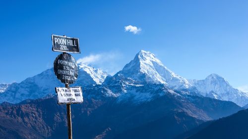
Poon Hill
The Himalayan viewpoint of POON HILL (3193m) provides a tempting destination amid the steep, lush hill country between Pokhara and the Kali Gandaki. This trek doesn’t take you right in among the mountains but, weather permitting, there are outstanding vistas and handsome Gurung and Magar villages. The trails are wide and well maintained (though steep in places), the lodges are large and comfortable, and the altitude shouldn’t present any problems – though you will need warm clothes at night. Rain gear is advisable.
Most people do Poon Hill as a loop from Pokhara, starting at Birethanti (1050m), just below the roadside settlement of Nayapul. A road is being built up the Bhurungdi Khola valley towards Ghorepani (and at the time of writing had already reached Tikhedunga), but there’s little traffic, and for most people it’s still two shortish but relentlessly uphill days on foot via the handsome Magar village of Ulleri (1960m) and some fine rhododendron forest to Ghorepani (2860m) or, a little higher up, the thrumming cluster of lodges at Ghorepani Deurali. There’s no need to set your alarm at either, as you’ll be awakened at 4am by the daily stampede of Poon Hill sunrise-seekers. If clouds block your view, as they often do, it’s worth hanging on for an extra day for the sight of Annapurna South apparently looming over Annapurna I, and the hump-shouldered pyramid of Dhaulagiri.
Beyond Ghorepani Deurali, the trail descends the thriving, terraced valley of the Ghar Khola (and there’s a road being built here too; coming down, you’ll meet it near Shikha, though the trail stays off it and there’s next to no traffic). It finally plunges down to cross the Kali Gandaki on a splendid suspension bridge and arrive at the busy townlet of Tatopani (1190m), a fairly demanding day’s walk from Ghorepani. At Tatopani, there are banks (no ATMs as yet), restaurants, a health post and all the other facilities you might need, as well as the well-maintained hot springs beside the river, from which the town gets its name (it means “hot water” in Nepali). Frequent buses and jeeps head down to Beni and Pokhara.
For a slower return to Pokhara, head east from the old, lower village of Ghorepani, making for Ghandruk – one long or two short days’ walk. The first section to the lonely little cluster of basic lodges at Deurali (not to be confused with the Deurali above/north of Ghorepani) is a fine ridge walk through rhododendron forest, with great views of Dhaulagiri and Machapuchare, especially from the lodges perched at Ban Thanti (3180m); the descent to Tadapani (2630m) is steep and slippery. At Tadapani you join the Ghandruk route described under the Nayapul approach to the Annapurna Sanctuary, but you could easily make a longer loop, crossing to the east bank of the Modi Khola to rejoin the road at Phedi.
The Jomosom trek: the Kali Gandaki and Muktinath
The trek up (or down) the Kali Gandaki gorge from the pilgrim site of Muktinath and the Wild-West-style regional capital of JOMOSOM was for many years the classic Himalayan sampler, and the most developed stretch of trail in Nepal, with food and lodging closer to what you’d find in Thamel than the usual hill fare. Since the construction of an 83km road from Beni to Jomosom, on the west bank of the Kali Gandaki, many would-be trekkers are going elsewhere, though Indian pilgrims are replacing them (especially during festivals during auspicious seasons, notably April to June, and mid-August to mid-September – during the latter season, especially, guesthouses are full to bursting with tour groups). It’s still perfectly possible to do the trek, however, following new trails on the steeper eastern side of the valley or paths that weave on and off the road. Guides can show you some fantastic day hikes and overnight trips up from the valley floor, too: little-trekked trails lead to North Annapurna Base Camp, the Dhaulagiri Icefall (way out west of Larjung) and the high-level Dhampus Pass (5182m), the key to Dolpo.
Many trekkers fly to Jomosom and walk up to Muktinath, then down again, but you’ll have more sense of arrival (and acclimatize better) if you do the trek the hard way. The best approach route on foot is now from Nayapul to Tatopani via Poon Hill.
Tatopani to Jomosom
From Tatopani to Jomosom is typically three or four days’ walk – or a tough, scary day in buses and/or jeeps. It’s possible to avoid the road most or all of the way by following the eastern bank. That said, landslides are a perennial problem, meaning that the east-bank trails can be tricky or impassable in places – and information about the state of the route can be hard to come by. The main settlements (and most of the trekking lodges) are on the western side, and people there aren’t exactly keen to see the foot traffic pass them by. Path maintenance on the eastern side isn’t exactly a priority, for the same reason. Temporary wooden bridges make crisscrossing relatively simple in the dry season, but when the river is high, you may have to make strategic crossings at the permanent suspension bridges and resign yourself to walking on the road for longer stretches. Taking a guide who has walked the route recently would ease the logistics considerably.
Above Tatopani (1190m), where the trail from Poon Hill joins the road up from Beni, the route passes into the world’s deepest gorge, the Kali Gandaki, with the 8000m hulks of Dhaulagiri and Annapurna towering on either side. Above Tatopani, you often have to stick to the west bank, and near the old Magar village of Dana, you enter the steepest, sheerest part of the gorge; there’s a lookout point below the waterfall of Rupse Chhahara. The east bank trail from Kopchepani, just above and opposite the falls, up to Ghasa (2010m) is relatively good.
At Ghasa, you enter Lower Mustang district and the homeland of the Buddhist Thakali people – from here on up, the river is known locally as the Thak Khola, and subtropical greenery starts to give way to Alpine trees and shrubs. You usually have to stick to the west bank from Ghasa to the village of Chhyo, opposite Lete (2480m), but from there a good east-bank trail climbs up to Kunjo and the little lake of Titi Tal before dropping down, partly on a rough road, to the well-established trekking village of Kokhetanti (2545m), where you are usually forced to re-cross the river to Larjung, on the west bank – the east-bank route up to Tukuche via Sirkung and Sauru is particularly prone to landslides. The relatively large and prosperous village of Tukuche (2590m) is the place to cross back onto the east bank, heading up via Chimang, with its lovely Dhaulagiri views, and Chairo, a Tibetan settlement. It’s usually possible to continue up the east bank directly to Thini, but it would be a pity not to cross over short of Dhumba to handsome, stony Marpha (2670m), which sits amid apricot and apple orchards – the cider and brandy are famous. The administrative centre of Jomosom (2720m), with its busy airstrip, looks like a stony Wild West settlement, but is useful for supplies, doctors, banks, police and so on, and great for those seeking respite – it has plenty of relatively fancy hotels.
Jomosom to Muktinath
Above Jomosom, the valley starts to level out, and you enter a dry and powerfully Tibetan-flavoured highland region. A few motorbikes and jeeps plug dustily up the rough road, though paths are easy enough to find, often on the stones of the valley floor. Beware the extraordinary late-morning and afternoon katabatic winds, however, which tear up from the south after about 11am, rushing to fill the void left by the hot air rising from the highlands above. The winds carry enormous amounts of grit and dust from the riverbed – and, nowadays, vehicle dust too – meaning that a scarf as a mask, a hat and sunglasses are vital. If you’re heading into the wind, coming down, walking can be anything from severely trying to almost impossible.
At the romantic fortress town of KAGBENI, with its medieval buildings and terracotta Buddhist figures, you’re on the very edge of the Tibetan plateau, and can gaze north into Upper Mustang. What with the expensive permit that’s necessary to visit (see The TIMS card), this really is a forbidden kingdom. Eastwards, however, it’s an open-access, 1000m climb towards Muktinath, up a delightful, open side valley dotted with orchards and lined with dry-stone walls. The trail crisscrosses the road, and takes you through the impressive village of Jharkot (3550m), where there’s a fine gompa. Jeeps can take you as far as Rani Pauwa (3710m), where dozens of hotels cater to the Indian pilgrim trade; from there you’d have to walk the last twenty breathless minutes to Muktinath, or buy a seat on the “Muktinath Express” – which means riding pillion on a motorcycle.
The Mahabharata mentions poplar-shaded MUKTINATH (3760m) as the source of mystic shaligrams, stone ammonite fossils found in the Kali Gandaki gorge. It is one of the most important religious sites in the Himalayas – and ever since the arrival of the road, a pilgrim boomtown. A priest will show you around the Vishnu temple, with its 108 waterspouts (where pilgrims bathe in the freezing water) and its shrine sheltering a tiny perpetual natural-gas flame hidden half-underground beside a little spring – a particularly holy combination of earth, air, fire and water. Yartung, a madly exotic festival of horseriding, is held at Muktinath around the full moon of August–September.
If you’re returning to Jomosom, it’s possible to take a dramatic, high-level side route over the shoulder of the hills to the southeast of Ranipauwa, descending on precipitous paths (and crossing the Panda Khola on temporary bridges – so ask before setting out) via the old-world Thakali village of Lupra. If you’re heading up over the Thorung La to follow the Annapurna Circuit towards Manang, bear in mind that there are a couple of basic high-season-only teahouse lodges at Chabarbuk (4200m), also known as Phedi, just before the zigzagging, four-hour climb up the pass begins; sleeping here would get you an hour’s head start in the morning.
Manang and the Marsyangdi Valley
The MARSYANGDI VALLEY, which curls around the east side of the Annapurna range, was once the less commercialized half of the Annapurna Circuit, trekked only by the hardcore few intending to cross the 5415m pass of the Thorung La and descend towards Jomosom. With the opening of a new road, it is eclipsing its cousin as a destination in itself and the base for some stunning side treks. At the time of writing you could drive all the way to Manang – subject to landslides and the usual roughness of road – except for one short section between Tal and Karte, which was still under construction. Expect this section to be completed, but other sections to be periodically buried and rebuilt.
The main trailhead is at Besisahar, but in good conditions jeeps penetrate the valley as far as Syange. With a guide, you could also walk in two to three days from Begnas Tal, via Nalma Phedi and Baglungpani, to Khudi, just north of Besisahar.
The Upper Marsyangdi to Manang and the Thorung La
Above the riverside settlement of Syange, the road is (or was at the time of writing) left behind, and the trail passes from terraced farmland into the gorge of the Upper Marsyangdi; and it’s three or four marvellous days’ walk up to Manang, mostly through Buddhist country. The trail crosses astonishing suspension footbridges and passes along dramatic walkways blasted into the rock, all the time climbing through successive climatic zones: temperate forest, coniferous forest, alpine meadows and finally the arid steppes of the rain shadow. The walk from Chame to MANANG – the high route via Upper Pisang avoids the bizarre stretch of unconnected road below – is spectacular and shouldn’t be rushed. The sight of the huge, glacier-dolloped Annapurnas towering almost 5000m above the valley will stay with you forever. Manang’s architecture, like that of all the older villages here, is strongly Tibetan.
The Thorung La (5416m) is iffy to impossible from late December till early March, while the lower parts of the trek are uncomfortably warm from April onwards. Snow can block the pass at any time of year, so be prepared to wait it out or go back down the way you came. If you’re going for it, you’ll need proper boots, gloves, very warm clothes and a three- or, better, four-season sleeping bag; visit Manang’s Himalayan Rescue Association post for information on weather conditions, AMS and suggested pacing of the route. It’s only six or seven hours to Thorung Phedi (4450m), the last cluster of lodges before the pass, but you should spread the ascent over at least two days – perhaps making day-trips from Manang. Thorung Phedi and the worryingly high Thorung High Camp (4925m) are grotty places where you’ll be woken up at 3am by trekkers who’ve been told (wrongly) that they have to clear the pass by 8am. Afternoons do get very windy, though, so an early start is advisable. The climb up the pass (where there’s sometimes a teashop in high season), and the knee-killing 1600m descent down the other side to Muktinath is a tough but exhilarating day.
Short side trips from Manang
Manang makes a fine base for exploratory day hikes around the Upper Marsyangdi valley – ideal for acclimatizing if you’re crossing the Thorung La, and worthy as destinations in their own right. The gompa at Manang, Bojo and Braga, all within half an hour of each other, are well worth visiting, and you could add on a short stroll from Manang to Gangapurna Lake and the fine viewpoint two hours above. Kicho Tal (4950m), an icy lake where bharal (blue sheep) have been sighted, makes a fine day hike.
The most enticing destination west of Manang is TILICHO (sometimes called Tilicho Tal or Tilicho Lake), not the highest lake in the world, as is often said, but beautiful and remarkable nonetheless. Getting there is two or three days’ hard work: paths are scree-ridden and dicey, routes may be hard to find and lodges are often shut out of season. Take advice and, if possible, a guide.
Two tricky hours west of Manang, Khangsar (3734m) is the highest permanent village in the Marsyangdi valley; it has a few lodges. From here the trail doesn’t follow the landslide-prone Marsyangdi valley, but a higher northern route passing Kharka (also known as Srikharka or Shreechaur; there’s a good guesthouse here) and a high col (4920m), descending to Tilicho Base Camp (4150m), some five hours from Khangsar. A second overnight at one of the two icy lodges at Tilicho Base Camp would make possible a steep day-trip the next day towards the astounding, often iced-over lake, Tilicho (4920m), a further three hours up (on snow, in parts, between November and May). There is currently just one very basic, seasonal teahouse (dorm room only) beside the lake, on the Manang side, but check if it’s open before you head up without camping gear. Most people visit the lake as a day’s round-trip from Tilicho Base Camp, but the hardy return to Khangsar (or even Manang) in one long day.
Tilicho is not a trip for the inexperienced; still less is the high, snowy, dangerous route through to Jomosom (or Marpha). The lakeshore can’t be circumnavigated (whatever maps may show), so the route demands either a roped-up crossing of the frozen lake (very roughly Nov or Dec–April, but make sure), or a high detour to the north across the Eastern Pass (5340m). After that you have to cross the watershed range, usually via the perilous MESOKANTO LA (5121m), sometimes called the Middle Pass (as there is a higher but supposedly easier one to the north). Only very strong walkers should expect to make it down to Jomosom (or even Thini) in one day from Tilicho Lake; ten hours would be fast, so it’s better to camp at one of the two sites along the way.
Other Annapurna region treks
The following four treks have little in common with the well-serviced routes described above. You’ll typically find only Nepali food and lodging, or will need to camp – and possibly stay in people’s homes for at least some nights. If you’re not trekking with an agency, you’ll probably want to go with a guide.
Of course, there are scores of possibilities beyond the treks described here. The Khopra Lake trek, on the shoulder of Annapurna South above Ghorepani and Tadapani, could one day rival Poon Hill in popularity, with its stunning views towards Dhaulagiri, and high point at the small, sacred Khayar Lake (4880m). There’s no lodge at Khopra, but in 2012 a guesthouse was being built at Dharamdanda, halfway between Tadapani and Khopra Danda; you can also stay at Swanta, above Chitre. Increasing numbers of trekkers are exploring west of the Kali Gandaki towards the Dhaulagiri massif and the little-visited Dhorpatan Hunting Reserve; beyond that, of course, there’s Dolpo.
The Machhapuchhare trek
One of the newer routes in the region takes a loop north of Pokhara, towards the south faces of Mardi Himal and MACCHAPUCHHARE, with fine views of the Annapurna wall. The usual approach route heads up the upper valleys of the Seti Khola, leaving a spur road just above Hyangja (20min by taxi from Pokhara), and passing through lush, terraced farmland around the Gurung villages of Ghachok and Diprang (1440m), where there’s a community lodge and a natural hot spring nearby. A choice of steep paths lead up through forest (one passes Pipar Lake, prime pheasant habitat with a stunning view of Machapuchare, looming just to the north) to a high ridge dripping with rhododendrons and alive with birds, which you can follow up to the minor peak at Korchon (3682m), and potentially on up in the direction of Mardi Himal Base Camp (4120m). Most treks descend the ridge before dropping to the Mardi Khola at the village of Ribang. The trek takes five to seven days, and requires camping and supplies.
Mardi Himal trek
One ridge to the west of the Macchapuchhare trek is another fine camping route, the MARDI HIMAL TREK. The usual starting places are at Phedi or Kande, both on the road to Nayapul. From either, you climb on well-made trails to the villages of Pothana (1890m) and Bhichok Deurali (2100m). From here, you ascend the incredible ridge that drops south from Mardi Himal (5553m) between the Mardi and Modi Kholas. There are stunning views from the ridgetop, while rhododendron forests drop away on either side, and campsites appear every four hours or so: at Kokar (2550m), Low Camp (3050m) and High Camp (3900m). From High Camp, you can continue on up the ridge as high as you dare – it’s snowy from around November. From Low Camp, a good, steep trail drops east through the forest towards Sidhing, on the Macchapuchhare Model Trek.
The Royal trek
The so-called ROYAL TREK, an undemanding if somewhat unexciting amble through lush countryside, gets its name from Prince Charles’s visit in 1981. It was more enticing then, before the road was build east from Pokhara to Kalikasthan, and concrete houses started replacing traditional homes in places. It’s usually done over three (sometimes four) days, staying in homestay-style lodges. The first day follows gradual ups and downs as you head eastwards from Kalikasthan to Lipeyani; the second takes you up to ridgetop Chisopani (the last section is steep, but never scarily so), where there are fine views of the mountains; the third takes you back to Rupa Tal, from where you can pick up a bus to Pokhara.
The Siklis trek
The SIKLIS TREK probes an uncrowded corner of the Annapurna Conservation Area under the shadows of Lamjung Himal and Annapurnas II and IV – though you’ll see more terraced fields than mountains and forests. The usual itinerary takes about a week, starting at Begnas Tal and heading north to Kalikasthan (first night) then following the river’s west bank to Taprang (second night) and on up to well-preserved Siklis (1980m), Nepal’s biggest Gurung village. The fourth day is hard work: you strike westwards over the thickly forested ridge that separates the Madi and Seti drainages to Tara Hill, where a small teahouse offers incredible views of Macchapuchhare; you then descend via Ghalekharka and the Sardikhola to the Seti Khola, returning towards Hyangja via Ghachok. Many other variations are possible, including making a detour up the Seti Nadi from Ghachok to the hot springs at Diprang. It’s now possible to make this trek without camping or staying in local homes, but the lodges are still pretty basic.
The Manaslu Circuit
There’s only one trek of note in the region east of the Annapurnas and north of Gorkha: the MANASLU CIRCUIT. It’s some trek, however, passing through relatively unspoiled and hugely varied countryside, from rice terraces to spare Tibetan villages, and from rich forest to a 5100m pass. It takes two weeks (13–18 days) to walk the challenging route, and it’s well worth considering if you were thinking of doing the Annapurna Circuit and were put off by the new road or the increased commercialization.
It is now possible to trek the Manaslu Circuit by staying in lodges, without taking camping equipment, but the facilities are, for the most part, quite basic. Things are changing fast (w manaslucircuittrek.com is a good place to seek traveller reports and updates), but this is still daal bhaat and shared dormitories territory.
The trek traditionally starts in Gorkha, passing right next to the royal palace and then through some very scenic and culturally rich country. Many people now shave off the first three days or so, however, by beginning at Arughat. Direct buses run from Kathmandu to Arughat (2 daily; 7hr), or you can get off the Prithvi Highway between Kathmandu and Pokhara at Malekhu, and catch frequent local buses or jeeps from there up the paved road to Dhading, a busy administrative centre, and then on up the rough road that continues to Arughat (and indeed beyond, as far as Arkhet or Sozti Khola).
The Manaslu Circuit route
From Arughat (530m), the first eight days or so climb steadily up the wooded, peaceful Burhi Gandaki valley. You’re passing through deep Gurung country, where local women wear heavy gold jewellery, and working men carry the distinctive Gurung bhangro, a heavy, cream-coloured rough woollen cloak which is cross-tied around the waist and shoulders and doubles as a bag.
After three or, more likely, four days, you pass into the Manaslu Conservation Area at Jagat (1340m), where there’s a checkpost, and the scenery becomes ever more spectacular. (A fascinating side trip would be east of Philim up to the stunning, forested and intensely Buddhist Tsum valley, which penetrates behind the 7000m peaks of Ganesh Himal.) Beyond Deng (1800m), one long or two short days above Jagat, the valley starts to turn west and you enter the high, strongly Tibetan-flavoured country of Nupri; it’s three or, more sensibly, four days up through increasingly lofty, Buddhist country to the town of Samdo (3870m). It’s worth taking your time to acclimatize, and Samdo, with its cluster of relatively comfortable lodges, and possibility of a side trip towards the Lajyung La (which leads into Tibet), is a good place to take a rest day. If need be, porters can be hired here – at a price.
It’s inadvisable, on acclimatization grounds as well as those of fatigue, to try to do one huge, 10hr day from Samdo all the way over the pass of the Larkya La (5135m) and down to the lodges at Bimtang (3720m). The only alternative, if you’re not camping, is the single lodge at Larkye La Phedi, also known as Larkye Dharamsala (4470m), three hours above Samdo; at the time of writing, however, there was a question over its future, as it was built illegally. The Larkya La itself, which clings to the very shoulder of Manaslu, takes four to five hours to ascend from Larkya Phedi, and can be windy and dangerous; in snowy conditions, which are common (and should be expected from November), guides should use a rope for the steepest hour or two of the descent. The views are sensational, even if they don’t take in an 8000m peak – only Annapurna II, at a shade over 7900m.
The descent can be very fast: two to three steep days down the Dudh Khola to the Marsyangdi valley. At Dharapani (1860m), you enter the ACAP zone (permit needed) and relative civilization. You meet the road at Syange, where jeeps come up from Besisahar, but it might be preferable to walk to Bhulbhule.
The Everest region
EVEREST is more a pilgrimage than a trek: a tough personal challenge with a clear goal at the end, it passes deep into Buddhist Sherpa country, among some of the world’s most sublime peaks. In terms of popularity, the region runs second to Annapurna. That said, the majority of trekkers in Solu-Khumbu, the Everest region, are all heading up the same trail. From the alarming airstrip at Lukla, the trail leads north into mountainous Khumbu, the dizzyingly high Sherpa homeland. The trail forks above the Sherpa capital of Namche Bazaar (or Namche for short): one route leads to Everest Base Camp and the viewpoint of Kala Pattar; the other for the beautiful Gokyo Lakes. Both high points are about eight days from Lukla, and can be combined by crossing the high pass of the Cho La.
Relatively few trekkers now take the switchback hike from the roadhead at Jiri through Solu, the lower, greener, more populous and more ethnically diverse country to the south. It’s a stunning route, and offers a great way to acclimatize, but the extra five to seven days’ walking is too much for many people. You should leave slack in your schedule even if you’re flying, though, as getting a place on a plane out of Lukla can be problematic if bad weather causes cancellations to stack up.
To get a good look at Everest, you’ll have to spend at least four nights above 4000m and at least one at around 5000m. At these altitudes, there is a serious risk of developing acute mountain sickness (AMS) and you must know the signs (see Altitude). Everest is also the coldest of the major treks, so you’ll need a good sleeping bag, several layers of warm clothes, and sturdy boots that will keep out snow. The rental shops of Namche, in Khumbu, allow you to stock up on high-altitude gear and return it on the way back down. Because of weather, the trekking “window” is especially short in Khumbu – early October to mid-November, and late March to late April – and this, in turn, creates a seasonal stampede on the trails and at the Lukla airstrip. Winter isn’t out of the question, but it’s just that much colder.
While Everest isn’t as heavily trekked as Annapurna, its high-altitude environment is even more fragile. Khumbu, with less than four thousand inhabitants, receives anything from ten to twenty thousand trekkers a year, and probably twice as many porters. Lodge-building almost destroyed the Blue Pine and Silver Fir forests around Lukla, and the demand for firewood is many times the regeneration capacity of the area. Near trekking villages, up to half the juniper shrubs have vanished in smoke. The Sagarmatha National Park, which covers most of Khumbu, has done some fine work in reforestation (funded by the Rs1000 entry fee), but it can’t be said often enough: have as little to do with wood-burning as possible.
The popular trails through Solu-Khumbu are well equipped with lodges, some basic, some fancy and surprisingly expensive – until you consider the costs of portering in all supplies this far. Prices rise as you ascend; near the top, most lodges offer basic bunk beds only. The main Jiri–Lukla–Namche–Base Camp route is very straightforward, as is the alternative high-level spur, to the Gokyo lakes, but a guide is advisable for pretty much anything else. Solu-Khumbu is the easiest area in Nepal to hire a woman porter – a Sherpani – although few speak enough English to serve as guides.
Everest Base Camp
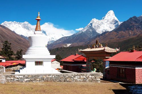
From Lukla (2840m), the trail powers north up the Dudh Koshi (“Milk River”) before passing into Khumbu and the Sagarmatha National Park at Jorsale (2740m), and bounding up to lofty NAMCHE BAZAAR/NAMCHE (3450M), where Khumbu and the serious scenery start. Nestled handsomely in a horseshoe bowl, the Sherpa “capital” has done very well out of mountaineering and trekking over the years, and shops sell (or rent) absolutely anything a trekker could desire. There’s also a bank (with, astonishingly, an ATM), a post office, a bakery, a place calling itself “the world’s highest bar”, and even internet access. Try to make your trip coincide with the Saturday market, which draws Tibetans from the north and Rais from the south, or visit the national park visitors’ centre, perched on the ridge east of town, which contains an informative museum. Thame, a beautiful few hours’ walk west of Namche, makes an excellent side trip.
There are numerous possibilities above Namche, including passing through the relatively untouristy and unusually flat settlements of Khumjung (3780m) and Khunde. The main route contours to Sanasa (where the trail to Gokyo breaks off), before descending to cross the genuinely milky-looking Dudh Koshi (“Milk River”), at Phunki Tenga (3250m). The trail veers northeast into a tributary valley and climbs steeply to Tengboche (3860m), where the wildlife-rich juniper forest has long been protected by the local lamas and there’s a show-stealing view of everybody’s favourite peak, Ama Dablam (6828m) – the “mother with a jewel box”, as Sherpas call it. Tengboche’s large monastery was lavishly rebuilt in the early 1990s, and has a fascinating permanent exhibition. Mani Rimdu, the Sherpa dance-drama festival, is held here on the full moon of October–November. The trail briefly descends through birch and fir forest to Deboche, a settlement with a nunnery, before ascending again to Pangboche, containing Khumbu’s oldest gompa, where for a donation the lama will show you some yeti relics. (The higher trail leading west out of Pangboche allows you to cut across to the Gokyo trek, on the opposite side of the Dudh Koshi valley.) After crossing the Imja Khola, the trail follows the terraces of the valley floor to Pheriche (4250m), site of a Himalayan Rescue Association post (AMS talks are held most afternoons, and $50 consultations are available). Above Pheriche, the stone and slate-roofed Sherpa settlements are strictly seasonal – trekking lodges aside.
The village of Dingboche (4360m), in the valley of the Imja Khola a little above Pheriche, is a slight detour from the fastest route up, but sitting right under Ama Dablam as it does, it has a more appealing situation than Pheriche, and offers some fine acclimatization side trips: to a gompa 400m above, or further up the Imja Khola to Chhukhung (4730m). This sensationally situated village is tiny, with only a few lodges, but can serve as a base for higher explorations still: on to Imja Tso (a glacial meltwater lake marooned in moraine that threatens to burst), up to the peak of Chhukung Ri (5546m) or ascending towards the Kongma La. The Dingboche route rejoins the trail up from Pheriche at Dughla (4620m), which is where acclimatization problems set in for many trekkers. Do not ascend with symptoms of AMS. Immediately above the trail climbs the stony terminal moraine of the Khumbu Glacier, passing a series of monuments to Sherpas killed on Everest, to reach Lobuche (4930m). Another day’s march along the grassy edge of the glacier’s lateral moraine brings you to Gorak Shep (5180m), the last huddle of lodges – and a cold, breathless and probably sleepless night in uncomfortably crowded bunk rooms.
The payoff comes the next day, when you climb up the mound of Kala Pattar (5545m): the extra height provides an unbelievable panorama, not only of Everest (8848m) but also of its neighbours Lhotse (Nepal’s third-highest peak, at 8516m) and Nuptse (7861m), as well as the sugarloaf of Pumori (7165m), the “daughter mountain”. A separate day-trip can be made across the thrillingly ice-spired Khumbu Glacier to Everest Base Camp. The trail is well trodden by climbing expeditions and their yaks and porters, so you don’t need any technical equipment beyond stout boots. Only the very fittest and best-acclimatized can manage Kala Pattar and Base Camp in one day; if you have to choose one over the other, make it Kala Pattar.
The Gokyo Lakes spur and Cho La
You’re that little bit further away from Everest, but the scenery is every bit as good at GOKYO LAKES, in the next valley to the west, and the lodges are much more appealing, with their glazed-in sun decks. The route breaks off the Base Camp trail at Sanasa, below Khumjung, following the Dudh Koshi north via Machhermo (where there’s an HRA medical post) to Gokyo, a cluster of lodges set beside the Ngozumba Glacier – the biggest in Nepal. It can be done in a long day if you’re fit and acclimatized; two or three if you’re not – there are lodges at frequent intervals all the way up. Several jewel-blue lakes, dammed up by the glacier’s lateral moraine, dot the west side of the valley above and below Gokyo. The high point is an overlook, Gokyo Ri, surveying a clutter of blue teeth – Cho Oyu, Everest and Lhotse are just the ones over 8000m – and the long grey glacier tongue.
It’s possible to be in Gokyo in two days from Gorak Shep (or vice versa), if you can manage the strenuous CHO LA (5420m). There are a couple of simple lodges at Dragnag (4700m), four hours from Gokyo, on the opposite side of the glacier, and a couple more at the unappealing Dzonghla, two to three hours from Dughla or Lobuche (4910m). But the high, middle section, crossing the pass, has to be done in one long day (unless you have tents): that’s six to eight hours, or more in bad conditions or if you suffer from altitude problems – which is all too likely this high. The pass is usually snowy on the eastern side, where you have to cross onto a glacier, with some tricky and slippery sections. Don’t attempt it if you’re in any doubt about the weather, or your own condition, and team up with a group. In good autumn and spring conditions, full crampons aren’t usually necessary, but mini-crampons are an excellent, lightweight idea, and an ice axe could be handy; a guide or a thorough understanding of the route is essential.
Solu: the Shivalaya walk-in
The SHIVALAYA WALK-IN is one of the classic Middle Hill treks in Nepal, and the crowds flying straight in to Lukla don’t know what they are missing. Cutting across the lay of the land, the trail dips and soars between tropical valleys as low as 1500m and alpine passes as high as 3500m, but the sense of excitement as you get closer to the mountains proper makes all the gruelling legwork worthwhile – not to mention the fitness and acclimitization you’ll accrue. A few glimpses of peaks – notably Gauri Shankar (7145m) – urge you along during the first five or six days, although the lasting images of the Solu region are of tumbling gorges, rhododendron forests and terraced fields hewn out of steep hillsides. Expect to walk for six or seven days to reach Lukla, not counting side trips – but thereafter you’ll be walking much faster than those flying in, skipping up to Namche Bazaar in a day from Lukla. The bulk of traffic through Solu consists of porters humping in gear for trekking groups and expeditions flying into Lukla, and this is reflected in the relatively no-frills food and lodging available.
There are a number of variations on the route, but essentially you’re switchbacking over three passes, each bigger than the last. After the steamy, bustling riverside bazaar of Shivalaya (1770m) you climb over the pass at Deurali (2710m) – an alternative side route takes you higher, via the cheese factory at Thodung (3091m) – and down via the handsome village of Bhandar (2190m) to another settlement on the warm valley floor: Kinja (1630m). It is possible to get transport from Shivalaya to Bhandar, where the road ends, but you won’t save much time and the road is slow and deeply uncomfortable.
Most people choose to break the monumental third climb that lies ahead into two parts by spending their third night out of Jiri at Sete (2575m), halfway up to the Lamjura La (3530m), a pass where you first taste the scale of the mountains ahead. From there, it’s a long descent through forest to the idyllic quasi-alpine Sherpa village of Junbesi (2680m). Most trekkers are understandably impatient to get up to Everest, but a side trip to the powerfully Tibetan Thubten Chholing Gompa, north of Junbesi, is well worth it, and it’s possible to spend many days in the area. The airstrip at Phaplu is just two hours south, and immediately below that is Solu-Khumbu’s rarely visited capital, Salleri, a long strip of two-storey houses strung out on a green hillside, with a thriving Saturday bazaar at its bottom end.
Less than two hours above Junbesi, Everest View gives the first serious view of the Khumbu range, with Everest itself apparently subsidiary to the nearer peaks. The next pass, Traksindho La (3071m), finally takes you into the Dudh Koshi Valley and, at Jubing, an attractively bamboo-festooned Rai village below, the trail bends north towards Everest. Two days later, it sidesteps Lukla and joins the well-trodden route to Khumbu.
The eastern routes
The EASTERN ROUTES to or from Everest are sometimes treated as an exit by trekkers who want to avoid the long backtrack to Shivalaya, but there’s no reason why the itineraries can’t be done in reverse, except perhaps that it’s better to gain some confidence before tackling this less-trekked region. Another factor to consider is the season: try to do the lower section of the trek when it’s cooler. The routes are equipped with lodges and a guide isn’t needed, but don’t expect many English signs or much fancy food.
From the Everest region, the most interesting route leaves the Shivalaya walk-in at Kharte, about a day south of Lukla, and heads southeastwards to reach Tumlingtar five to seven days later, crossing three passes over 3000m. Part of this stretch traverses the Makalu-Barun Conservation Area, and the Rs1000 entrance fee may be required at a checkpost. The first half of the trek passes through tangled hills inhabited mainly by Rais; after reaching the last and highest pass, the Salpa Bhanjyang (3350m), it descends steadily to the deep, hot valley of the Arun – the traditional Rai homeland, though with a strong Hindu-caste presence. After crossing the river at a mere 300m, it’s a short day to Tumlingtar, a busy bazaar overlooking the Arun River; from here there are flights twice daily or more to Kathmandu, or you can pick up a local bus for the tortuous journey back via Chainpur and Basantapur to Hile.
Other routes head south from the Tragsindho La or, alternatively, Junbesi, to the Phaplu airstrip, which is now connected by road to the Terai. A full route description, is included in Mountain biking. Another southbound route aims roughly due south from Jubing down the Dudh Koshi, then bounds across the big hills on the eastern side of the valley and over to Lamidanda airstrip.
The fabled yeti
The yeti (“man of the rocky places”) has been a staple of Sherpa and Tibetan folklore for centuries, and takes three forms: the grey- or reddish-haired, man-like drema, who portends disaster; the huge, bear-like chuti, who preys on livestock; and the red or golden-furred mite, who sometimes attacks humans. Stories of hairy, ape-like creatures roaming the snowy heights first came to the attention of the outside world when explorers reported seeing mysterious moving figures and large, unidentified footprints in the snow. Captivated by the reports, an imaginative Fleet Street hack coined the term “abominable snowman”, a wilful mistranslation of metoh kang-mi, or “man-bear snow-man”, which was how a Sherpa guide described the creature during the 1921 Everest reconnaissance expedition. It wasn’t until 1951, during the first British Everest expedition from the Nepal side, that climber Eric Shipton took photographs of supposed yeti tracks. Since then, several highly publicized yeti-hunts, including one led by Sir Edmund Hillary in 1960, and others led by Reinhold Messner in the 1990s, have brought back a wealth of circumstantial evidence – Messner claimed to have seen a yeti in Tibet himself in 1986 – but not one authenticated sighting, spoor or hair sample. Oversized footprints could be any animal’s tracks, melted and enlarged by the sun. Meanwhile, “yeti” scalps kept at various gompa have been revealed to be stitched-together animal skins, while the skeletal hand at Pangboche is likely to be a human relic.
Messner eventually concluded that his yeti was simply a Himalayan black bear. Zoologists observe, however, that most sightings emphasize the redness of the creature’s hair, which rather suggests that an unknown primate might indeed exist in the high Himalayas. The sadder conclusion is that yetis did indeed exist, within human memory, but, like so many other Himalayan species, they’re either so critically endangered as to be almost invisible, or extinct.
Trekking independently
Trekking independently – making all your own arrangements, carrying your own pack and staying in lodges – saves money and may give you more freedom or flexibility on the trail. In terms of route choice, however, it’s more limiting than an organized trek.
Doing it yourself gives you more control over many aspects of the trek: you can go at your own pace, stop when and where you like, choose your travelling companions and take rest days or side trips as you please. The downside is that you have to spend a day or three lining up bus or plane tickets, renting equipment, buying supplies and perhaps tracking down a porter or guide. A more serious drawback is that you’re effectively confined to the more popular trails; trekking to remote areas is difficult unless you speak Nepali or you’re prepared to deal with considerable porter logistics.
An independent trek is likely to be less comfortable than one arranged through an agency. Lodges can be noisy and lacking in privacy, and there may be long waits for food of dubious quality. The active social scene in lodges goes a long way to compensating for this, however – even if you start out alone, you’ll quickly meet up with potential companions.
By not being part of a group, you’re better placed to learn from Nepali ways rather than forcing local people to adapt to yours. Equally important, a high proportion of the money you spend goes directly to the local economy (whereas most of the money paid to trekking agencies goes no further than Kathmandu, and often finds its way overseas). However, as an independent trekker you must guard against contributing to deforestation. If you or your porters or guides order meals cooked over wood fires, you encourage innkeepers to cut down more trees. Fortunately, kerosene is replacing wood in the most popular areas.