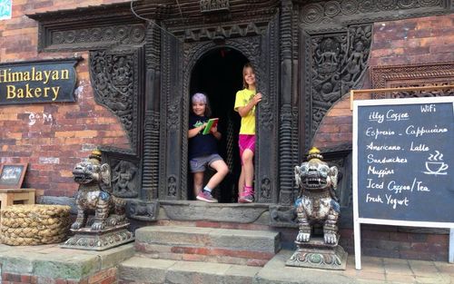
The Central Hills Travel Guide

It’s only when you leave it that you appreciate just how extraordinary the Kathmandu Valley is, surrounded by a 700km band of jumbled foothills that offer barely enough flat land to build a volleyball court. Only half a dozen roads fight their way out of the valley, but they are enough to make the Central Hills the most accessible area in the largely roadless hill country – though not necessarily the most travelled. To the northeast, the Arniko Highway follows the old Kathmandu–Lhasa trade route through broad valleys and misty gorges to the Tibet border; northwestwards, the Trisuli road snakes its way down into a subtropical valley nearly 1000m lower than Kathmandu; while west and then south, the Tribhuwan Rajpath, Nepal’s first highway, takes a wildly tortuous route on its way to the Terai. The scenery in this area is a shade less dramatic than you’ll encounter further west, but the land is nonetheless varied, rugged and only partially tamed by defiant terraces.

The majority of places in this chapter are easy overnights from anywhere in the Kathmandu Valley. The most popular are those that involve mountain views: Nagarkot and Dhulikhel, with well-developed lodgings, are both acknowledged classics; while the former has slightly better vistas, the latter boasts some interesting Newari architecture. The village of Daman has the most comprehensive views, but requires a little more effort to reach. These vantage points can’t compare with what you’ll see on a trek, but they do provide a taste of the Himalayas and can also serve as springboards for hiking and mountain-biking trips. The Tibet border area, meanwhile, has big appeal for adventure-sports enthusiasts: a trio of resorts in this area offer a wide range of activities including canyoning, whitewater rafting, kayaking and one of the world’s highest bungee jumps.

Although cultural attractions are relatively few outside the Kathmandu Valley, Panauti is among Nepal’s most intriguing small towns – all the more so because it is so seldom visited – with fascinating temples, bathing ghats and pilgrims’ houses. In the northwest of the Central Hills, the peaceful village of Nuwakot is also a worthwhile destination, with a superb fortress and a lovely hillside location.

To an extent, the boundaries of this chapter are dictated by travel formalities: towns and day hikes are described here, while longer backcountry treks are covered in Trekking. Many of the places described in this chapter could even be strung together with destinations in the Kathmandu Valley to create one long quasi-trek or mountain-bike ride.

Despite a relative abundance of roads, buses in the Central Hills are slow and infrequent. However, the region does contain some of Nepal’s most popular and rewarding mountain-bike and motorcycling routes.

Nagarkot

Set on a ridge northeast of Bhaktapur, NAGARKOT (1950m) has a classic panorama of the Himalayas. While the view isn’t as expansive as from Daman, and the area not as interesting as Dhulikhel, Nagarkot is easy to get to from Kathmandu and you don’t have to stay in an expensive hotel to get a fantastic vista from your window.

The first tourists to visit here are thought to have been a troop of Punjabi mercenaries recruited to defend the Valley against Prithvi Narayan’s troops. Stationed at the now-vanished ridgetop fort, they quickly succumbed to the “mountain air”, proving drunkenly incapable when the Gurkha invaders finally arrived. Since then, numerous guesthouses have sprouted along some two kilometres of ridge. Taking in the sunrise and sunset views is the standard activity, though there’s also a wealth of hiking and biking opportunities.

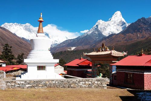
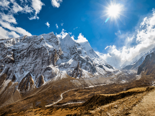
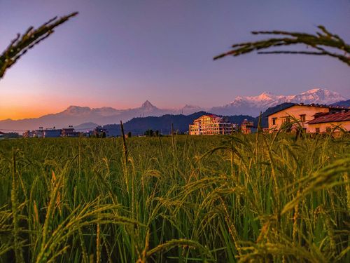
The view from Nagarkot

Most hotels in Nagarkot have good views, but they’re even better from the view tower at the highest southern point of the ridge (2164m), an hour’s walk from the centre along a tarmac road. When you get here you’ll understand why Nagarkot has been the site of a fort (kot) since Rana times: this hilltop controlled the eastern entrance to the Kathmandu Valley and the vital trade route to Tibet. There’s still a large army training base here, though relations with the community are strained after a drunken soldier killed eleven locals in 2005.

The view is dominated by the Langtang range, which on good days looms alarmingly close above a wall of dark rock. Haze usually obscures anything west of Ganesh Himal, though you can sometimes see Himchuli and even Annapurna. The view to the east is even more weather-dependent, and the mountains of Khumbu rarely appear as more than a rose-tinted dawn haze. On a good day, Everest can be seen, but only from high up, near the view tower: it’s the second peak left of the rounded M-shaped mountain.

On peak-season mornings the area becomes something of a tourist circus; for more peace, and equally good views, stop off at one of the grassy mounds just short of the tower. Nearer to the hotel area, there are good views from the tiny Mahakali shrine, from where the only obstructions are the ever-growing towers of Hotel View Point and Peaceful Cottage: good viewpoints themselves, they are accessible to non-guests, generally for free.

The Arniko Highway

Leaving the Kathmandu Valley through a gap at its eastern edge, Nepal’s only road to the Tibet border is the Arniko Highway (or Arniko Rajmarg). Constructed by the Chinese in the mid-1960s – to long-standing rival India’s great distress – the highway is a busy conduit for lorry-loads of Chinese goods by way of Lhasa. The first stop along the highway is Banepa, which together with Nala and Panauti once comprised a short-lived independent kingdom east of the Kathmandu Valley.

Adventure resorts on the Bhote Koshi

The raging Bhote Koshi’s reputation as one of the most extreme rafting rivers in Nepal, and the fact that there’s actually only about a day’s worth of rafting to be done, attracts a young, thrill-seeking crowd. The big rafting operators have been quick to develop the trend and, as well as the classic rafting trip, now offer mountain-biking, trekking, bungee-jumping and canyoning expeditions. Three major companies base their operations in attractive tented resort camps that – even if you’re not intent on throwing yourself downriver on a raft, or off a bridge attached to an elastic rope – make excellent bases for exploring the valley or just chilling out. Prices usually come as part of packages including activities, transport and meals.

Borderland Resort At the bottom of the gorge 9km north of Barhabise t 01 470 1295, w borderlandresorts.com; map. Ultimate Descents’ well-established resort is a sedate, relaxing place with three classes of tents, a pool and nice gardens.

The Last Resort t 01 470 0525, w thelastresort.com.np; map. Furthest north of the Bhote Koshi adventure resorts, Ultimate Rivers’ Last Resort has the most spectacular location, accessed by a footbridge suspended 160m above the gorge. The bridge also serves as the launching point for their bungee jump, one of the world’s highest. If the bungee doesn’t sate your appetite, you can always try the canyon swing as well. This is the funkiest of the three resorts, with the smartest tents, beautifully landscaped grounds, sauna, plunge pool and massage options, plus a sociable bar.

Sukute Beach Adventure Resort t 01 435 6644, w equatorexpeditionsnepal.com; map. Equator Expeditions’ Bhote Koshi resort is the closest to Kathmandu, sitting alongside a wide, relatively gentle stretch of the Sun Koshi between Dolalghat and the Balephi bridge. A mix of safari tents and rooms overlook a sandy stretch of the riverbank, and there’s an attractive swimming pool, restaurant and pool table.

Dhulikhel

DHULIKHEL is justly famous as a well-preserved Newari town, mountain viewpoint, and hiking and biking hub, though its popularity is waning as modernization takes its toll. Located 5km east of Banepa, just beyond the Kathmandu Valley rim, it sits at the relatively low elevation of 1550m, and is now something of a boomtown. It’s home to Kathmandu University and one of Nepal’s best public hospitals; meanwhile, its location on the new 158km route to Sindhulimadi and the eastern Terai seems likely to turn the place into one of Nepal’s principal transport junctions.

Old Dhulikhel

Old Dhulikhel starts immediately to the west of Mahendra Chowk, the main square at the newer, east end of town. A traditional Newari settlement, this area is comprised almost exclusively of four- and five-storey brick mansions, many with ornate wooden lattices in place of glass windows, some affecting Neoclassical detailing imported from Europe during the Rana regime. The older buildings, held together only by mud mortar, show some serious cracks from the infamous 1934 earthquake; Dhulikhel also experienced damage during a 1988 quake centred near Dharan in the Terai.

Highlights include the central square of Narayanthan, containing a temple to Narayan and a smaller one to Harisiddhi (both emanations of Vishnu), and the Bhagwati Mandir, set at the high point of the village with partial mountain views.

The sunrise walk

The most popular activity in Dhulikhel is hiking to the high point southeast of town in time for a sunrise over the peaks. To get to the top, take the road leading east from Mahendra Chowk for about 1km, passing a big recreation area on the left, and then go right at the next fork. Cyclists will have to stay on this graded road, but hikers can climb the more direct flights of steps. On foot, allow about 45 minutes from Dhulikhel to the top, as well as plenty of time for gawking at the numerous birds and butterflies – look out for the racquet-tailed drongos and turtle doves. The summit (1715m) is marked by a small Kali shrine and, unfortunately, a small military base and a microwave tower; a viewing platform was being built at the time of writing, and there is a café close by. The peaks from Ganesh Himal to Everest are visible from here, and the sight of Dhulikhel’s old town is pretty wonderful, too.

On the way back down you can call in at a small, mossy temple complex, hidden down a flagstone path that angles off to the left just past the Snow View Guest House. The main temple, known as the Gokureshwar Mahadev Mandir, contains a large bronze linga.

Panauti

Built on a single stratum of rock, PANAUTI is said to be the safest place in these parts to be when the next big earthquake hits. The best-preserved Newari town after Bhaktapur, it’s an enticing enough place at any time, leading a self-sufficient existence in its own small valley 7km south of Banepa. Its centre is a perfect nugget of extended family dwellings, temples and public meeting houses, all built in the Newars’ signature pink brick and carved wood, and at the bottom end is a cluster of riverside temples and ghats.

Wedged between the Punyamati and Roshi streams, Panauti forms the shape of a triangle, with a serpent (nag) idol standing at each of its three corners to protect against floods. Buses pull up at the newer northwest corner, but the oldest and most interesting sights are concentrated at the streams’ confluence at the east end of town, approached through a distinctive entry gate.

The shrine area at the sacred confluence, known as the Khware or Tribeni Ghat, is a tranquil spot. The large sattal (pilgrims’ house) here sports an eclectic range of frescoes depicting scenes from Hindu (and sometimes Buddhist) mythology: Vishnu in cosmic sleep, Ram killing the demon king Ravana, and Krishna being chased up a tree by a pack of naked gopi (milkmaids). Krishna is the featured deity of the pagoda temple next door, too, where he’s shown serenading his gopi groupies with a flute. Other small shrines dotted around the complex are dedicated to just about every deity known to Hinduism.

The Khware has been regarded as a tirtha (place of sacred power) since ancient times, and on the first day of the month of Magh (usually Jan 14), it draws hundreds for ritual bathing. Beside the river, the tombstone-shaped ramps set into the ghats are where dying people are laid out, allowing their feet to be immersed in the water at the moment of death. Orthodox cremations are held at the actual confluence, but local Newars are cremated on the opposite bank, apparently to prevent their ghosts troubling the town.

Tamangs

Tamangs, Nepal’s largest ethnic group, make up around twenty percent of the population and dominate the Central Hills between elevations of around 1500m and 2500m. With their origins in Tibet (Tamang means “horse trader” in Tibetan), the group follow a form of Buddhism virtually indistinguishable from Lamaism, though most also worship clan deities, employ shamans and observe major Hindu festivals. Despite their numbers, they remain one of Nepal’s most exploited groups, a situation dating back to the Gorkhali conquest in the late eighteenth century. Much of their land was appropriated, leaving them as tenant farmers, bonded labourers, woodcutters or stuck in menial jobs. The Tamangs today remain an underclass, locked into low-wage or exploitative jobs, or simply locked up (surveys suggest a disproportionate number are in prison).

The Namobuddha circuit

Although the scenery isn’t spectacular, the Namobuddha circuit is a pleasant day hike or a (much quicker) bike ride from Dhulikhel, with some interesting stop-offs en route. It’s worth trying to combine Namobuddha with a sunrise walk to the Kali shrine.

The route follows the road beyond the Kali shrine, passing through Khavre village, crossing the Sindhuli Highway after 2.5km, and contouring close to the crest of a ridge for another 7km to an intersection at a small saddle. True off-the-beaten-path riding can be found down any of the tracks off to the left in this section, particularly the one at this last junction (see the HMG/FINNIDA map series for details). For Namobuddha, though, bear right.

Resting on a red-earth ledge near the top of a jungly ridge, Namobuddha (or Namura) is one of the three holiest Tibetan pilgrimage sites south of the Himalayas. Similar in spirit to Boudha, it is something of a Tibetan Buddhist boomtown (or boom-village at least), particularly during the February/March pilgrimage season. The stupa celebrates the compassion of a young prince (in some versions, the Buddha himself) who encountered a starving tigress about to devour a small child, and offered his own flesh instead – a sacrifice that ensured his canonization as a Bodhisattva. The Tibetan name of the stupa, Takmo Lujin (Tiger Body Gift), links it explicitly to the well-known legend. According to one Tibetan scribe, the name Namobuddha (“Hail to the Buddha”) came into popular usage in the seventeenth century, when the superstition took hold that the site’s real name should not be uttered.

Among the homes and teahouses surrounding the stupa is a scruffy little Tamang gompa. Since the 1980s, however, the main Buddhist population at Namobuddha has been Tibetan. A steep path leads up to the ridge behind, which is festooned with chaitya, prayer flags and a collection of Tibetan monasteries, retreats and lesser stupas. In a small shelter near the top is a famous stone relief sculpture of the prince feeding his flesh to the tigress. If you want to stay overnight near Namobuddha it’s well worth checking out the couple of smart resorts nearby.

The road descends from Namobuddha to Sangkhu, where a right fork leads to Batase and eventually back to Dhulikhel along various roads or trails. However, it’s about the same distance (9km) to Panauti, and this is a preferable alternative if you have the time to spend the night there. From Panauti you can return to Dhulikhel a number of different ways by foot, bike or bus.

The Trisuli road

The Trisuli road was constructed in the mid-1960s as part of a hydroelectric project on the Trisuli River, northwest of Kathmandu. That’s the official story, anyway: the road probably owes its existence at least partly to historical nostalgia, as it retraces the triumphal approach of Prithvi Narayan Shah, Nepal’s founding father, from his fortress of Nuwakot to the Kathmandu Valley. The majority of travellers passing this way are only concerned about getting to Dhunche and Syabrubesi for the Langtang and Gosainkund treks, but Nuwakot and Kakani are both well worth visiting.

Nuwakot

One of Nepal’s proudest historical monuments, Prithvi Narayan Shah’s abandoned fortress looms like a forgotten shipwreck on a ridge above Trisuli, casting a poignant, almost romantic spell over the tiny village of NUWAKOT. It was from this command centre that the unifier of Nepal directed his dogged campaign on the Kathmandu Valley from 1744 to 1769. In his determination to conquer the valley, Prithvi Narayan had three other towers built in the name of the three valley capitals, perhaps hoping to bring about their downfall by a kind of voodoo; the Kathmandu and Patan towers share the main compound, while the crumbling Bhaktapur tower stands on a rise just outside.

Tribhuwan Rajpath: Kathmandu to Daman

Nepal’s most magnificent and hair-raising highway, the Tribhuwan Rajpath (usually just called the Rajpath, meaning “King’s Way”) heads west out of the Kathmandu Valley and then hurls itself, through an astounding series of switchbacks, straight over the Mahabharat Lek to the Terai. En route it passes through lush stands of rhododendrons (which bloom in April), and takes in superb views of the Himalayas, especially from Daman.

Built by Indian engineers in the mid-1950s, the Rajpath was the first highway to link Kathmandu to the outside world. At the time, India was on the brink of war with China and preferred to make any route through Nepal as inconvenient as possible to reduce the risk of invasion. Since the faster Mugling/Narayangadh route was completed, the road has become something of a backwater, which makes it perfect for mountain biking or motorcycling.

For its first 26km, the Rajpath follows the Prithvi Highway towards Pokhara. Leaving the Kathmandu Valley through its ugliest, most industrial corridor, it slips over a low point in the rim and descends to Naubise (945m), near the bottom of the deep Mahesh Khola Valley. At Naubise the Rajpath leaves the Prithvi Highway and forks left, climbing relentlessly for 30km to Tistung (2030m) before descending into the Palung Valley. The turning for Markhu and the Kulekhani Reservoir appears on the left 4km past Tistung, and the Newari village of Palung, at 1745m, is 5km beyond that. Daman is another 12km on, beyond which the Rajpath crosses the Sim Bhanjyang pass (2488m) where it begins a 2000m descent through jungle, forest and finally terraced farmland to the Bhimphedi turning, 40km from Sim Bhanjyang. Hetauda is 10km further on.

Daman

DAMAN (2322m) is the most comprehensive of the Himalayan viewpoints surrounding Kathmandu. Sitting below the Rajpath’s highest point, the hamlet overlooks the peaceful Palung Valley towards a magnificent spread of peaks. However, the mountains will probably be in clouds when you arrive: an overnight stay is obligatory to see them in their best morning light. The focal point of the village itself is an enclosed viewing tower that looks as if it might have been built for air traffic control.

Planning your own trip? Prepare for your trip

Use Rough Guides' trusted partners for great rates

Rough Guides Editors

written by Rough Guides Editors

updated 26.04.2021

Ready to travel and discover
Nepal?

Get support from our local experts for
stress-free planning & worry-free travels

Plan my trip ⤍