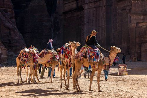
Crossing Wadi Mujib
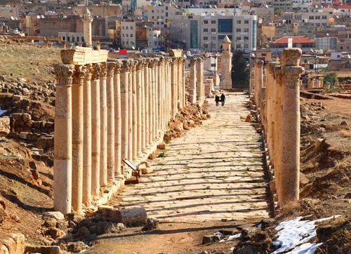
South of Madaba, the King’s Highway meanders up and down across several valleys draining rainwater off the hills, including the dramatic canyon of Wadi Mujib. One of Jordan’s most spectacular natural features, lying midway between Madaba and Karak, the immense valley has been dubbed, with a canny eye on the tourist dollar, “Jordan’s Grand Canyon”. The name, however, is well earned, as the King’s Highway delivers you to stunning viewpoints on either rim over a vast gash in the barren landscape, cutting through 1200m of altitude from the desert plateau in the east down to the Dead Sea in the west. It is every bit as awe-inspiring as its Arizonan cousin and has the added selling-point of the memorable road journey winding down to the valley floor and up the other side. A large chunk of the surrounding territory now forms part of the protected Mujib Biosphere Reserve, offering the chance for wilderness hiking and canyoning as good as any you’ll find in the Middle East.
The Mesha stele
These days a largely unregarded village, in the past Dhiban was an important city, capital of Moab and mentioned many times in the Old Testament. In around 850 BC, a man named Mesha, described as a “shepherd king”, liberated Moab from Israelite aggression, built a palace in Dhiban and set about refortifying the King’s Highway against future attack.
Almost three thousand years later, in 1868, a German missionary travelling in the wild country between Salt and Karak was shown by Dhibani bedouin a large basalt stone inscribed with strange characters. Unaware of its significance, he informed the German consul of his discovery, who then made quiet arrangements to obtain the stele on behalf of the Berlin Museum. However, a French diplomat in Jerusalem who heard of the discovery was less subtle; he travelled to Dhiban, took an imprint of the stele’s text and there and then offered the locals a large sum of money. Suddenly finding themselves at the centre of an international furore over a seemingly very desirable lump of rock, the bedouin refused his offer and sent him packing; they then did the obvious thing and devised a way to make more money. By heating the stone over a fire, then pouring cold water on it, they successfully managed to shatter it, and thus sell off each valuable fragment to the covetous foreigners one by one. Meanwhile, scholars in Europe were studying and translating the imprint of the text, which turned out to be Mesha’s own record of his achievements, significant as the longest inscription in the Moabite language and one of the longest and most detailed original inscriptions from the biblical period yet discovered. The mostly reconstructed stele now sits in the Louvre in Paris; having become something of a symbol of national pride, copies of it are displayed in museums all over Jordan.
Wadi Mujib
Some 2km south of Dhiban, the vast canyon of Wadi Mujib opens up spectacularly in front, over 500m deep and 4km broad at the top. Just over the lip of the gorge is a small rest stop and viewing platform. The dramatic canyon is an obvious natural focal point, and in biblical times, Arnon, as it was named, was the heartland of Moab, although with shifts in regional power it frequently marked a border between tribal jurisdictions; today, it divides the governorates of Madaba and Karak. The sheer scale of the place takes your breath away, with vultures, eagles and kestrels wheeling silently on rising thermals all around, and the valley floor to the right losing itself in the mistiness of the Dead Sea. The broad, flat plain of the wadi bed, now dammed, is noticeably hotter and creaks with frog calls.
Mujib Biosphere Reserve
Much of the area between the King’s Highway and the Dead Sea shore as far north as Ma’in, and including the lower 18km of the Mujib River, forms the Mujib Biosphere Reserve. This expanse of diverse terrain extends from the hills alongside the King’s Highway, at 900m above sea level, all the way down to the Dead Sea shore at 400m below sea level, and includes seven permanently flowing wadis within its 212 square kilometres. The biodiversity of this apparently barren area is startling: during ecological surveys of the reserve, four plant species never before recorded in Jordan were discovered, along with the rare Syrian wolf, Egyptian mongoose, Blanford’s fox, caracal, striped hyena, two species of viper, the venomous desert cobra, and large numbers of raptors. Nubian ibex roam the mountains on Mujib’s southern plateau. This is one of the most dramatic areas of natural beauty in Jordan – well worth the time and effort to experience.
Access to the reserve is generally from its lower entrance, by the Dead Sea road. The reserve’s only base at the King’s Highway end of the valley is a small office in Faqua village, northwest of Qasr, but this is not geared up for enquiries. Everything must anyway be booked in advance through the RSCN’s Wild Jordan tourism unit in Amman.
Most of the reserve’s hiking trails begin from the Dead Sea side. An exception is the rugged Mujib trail (15km; 7hr; JD45/person, minimum five people), a difficult route that begins from Faqua and descends rapidly into the reserve proper, ending at the Raddas mountain ranger station. It’s also possible to follow a difficult full-day route from Faqua all the way to the Dead Sea (April–Oct only), following the Mujib River with deviations at obstacles and passing through wild and varied scenery. This links up with the Malaqi Trail at the confluence of the Wadi Hidan for the final stretch down through the stunning Mujib Siq. All routes require an RSCN guide.
There are similar routes outside the reserve, around Wadi Zarqa Ma’in and Mukawir – and more further south around Karak, including the beautiful Wadi ibn Hammad.
Dolmens
Hidden away in the hills near Madaba are hundreds of dolmens (prehistoric burial chambers) and menhirs (standing stones). Many are hard to access or of limited interest, but a couple of sites stand out.
On the road from Madaba towards Ma’in, if you fork left at an avenue of trees about 1km before Ma’in village, after about 5km you’ll come to Magheirat (or Magheighat). Lines of Neolithic standing stones crisscross the road here; up on the hilltop to the right is a largely unexcavated stone circle in a double ring.
Back at Ma’in village, if you turn left and head south through orchards into open country – increasingly covered with white dust from a nearby quarry – you’ll see, on the left in an unguarded field, a Neolithic standing stone known as Hajar al-Mansub, carved (in antiquity) on its reverse side as an enormous phallus. Theories abound as to its purpose and context.
For the full low-down, make contact with dolmen enthusiast Charl Al-Twal, owner of Madaba’s Mariam Hotel. He’ll happily explain more about the dolmen fields in the area, including the one by Al-Faiha village at remote Wadi Jadid/Jdeid, 10km southwest of Madaba – and he’ll be able to fix you up with taxi transport as well (roughly JD20 return). Alternatively Terhaal runs an afternoon cycling tour from Madaba to Mount Nebo which passes by Wadi Jdeid (from JD25/person), meeting at the Mariam first. Book ahead.
Karak
The southern stretches of the King’s Highway pass through an increasingly arid landscape dotted with lushly watered settlements. Karak, unofficial capital of southern Jordan, still lies largely within its hilltop Crusader-era walls and boasts one of the best-preserved Crusader castles in the Middle East. Roughly 125km south of Amman, midway between the capital and Petra, it’s also a natural place to break a journey, especially on 10-day Jordan trips that follow the King’s Highway at a less hurried pace. Unfortunately, Karak is not well geared up for overnight stays, with poor access and distinctly average hotels. Drop in to visit the castle, then press onwards to more enticing destinations – Madaba to the north, Dana or Petra to the south.
Everything you need in Karak is within a few minutes’ stroll of the castle, at the highest point of town. Just in front of the castle is the Castle Plaza area, a tasteful complex of restored Ottoman buildings around a paved plaza beneath the castle walls, including the old Al-Hamidi mosque and a Visitor Centre. In sharp contrast is Karak’s humdrum town centre. Venturing down any of the narrow streets that lead north from the castle – most of them lined with grand but grimy Ottoman-era balconied stone buildings – will bring you nose-to-nose with Karak’s bustling everyday shops and markets. The focus of town is an equestrian statue of Salah ad-Din, occupying a traffic junction about 400m north of the castle, around which spreads Karak’s ramshackle souk – tailors, butchers, cobblers and all.
Karak castle
Occupying a rocky spur on the southern edge of the town centre, Karak castle is first, and most impressively, visible on the approach from the east, its restored walls and glacis looming above the ravine below. Access is from behind the Castle Plaza complex, across a wooden footbridge spanning the moat. The castle has seven levels, some buried deep inside the hill, and the best way to explore is to take a torch and simply let your inquisitiveness run free: it’s quite possible to spend two or three atmospheric hours poking into dark rooms and gloomy vaulted passageways.
Brief history
The hill on which Karak stands – with sheer cliffs on three sides and clear command over the Wadi Karak leading down to the Dead Sea – features both in the Old Testament and on Madaba’s Byzantine mosaic map as a natural defensive stronghold. The Crusaders began building a fortress on a rocky spur atop the hill in 1142.
The Crusaders
The castle’s construction was initiated by the knights of the successful First Crusade, but its eventual downfall is inextricably linked with Reynald of Chatillon, a ruthless warrior who arrived in the Holy Land in 1147 on the Second Crusade. Reynald was both vicious and unscrupulous, and it was specifically to avenge his treachery that the Muslim commander, Salah ad-Din, launched a campaign to expel the foreign invaders. In 1177, Reynald married Lady Stephanie, widow of the Lord of Oultrejourdain. Safely ensconced in Karak, he began a reign characterized by wanton cruelty: not only did he throw prisoners from the castle walls, he encased their heads in boxes first, in the hope that this would stop them losing consciousness before they hit the rocks below. In 1180, he robbed a Mecca-bound caravan on the King’s Highway in violation of a truce; Salah ad-Din was forced to swallow his anger until a suitable time for revenge could be found.
In 1183, the wedding of Reynald’s heir was celebrated within the walls of Karak castle at the very moment that Salah ad-Din and his army, having already invaded the town, were poised just beyond the north moat ready to attack. Lady Stephanie sent plates of food to the Muslim army beyond the walls. In response, while his men were trying to bridge the moat and catapulting rocks against the walls, Salah ad-Din enquired which tower the newly-weds were occupying – and then ordered his army to direct their fire elsewhere.
Karak withstood that siege, but at the Battle of Hattin in 1187, the Crusaders, stymied by the strategic ineptitude of Reynald and others, were defeated. The victorious Salah ad-Din characteristically spared the king and the Crusader lords – all apart from Reynald, whom he personally decapitated. The besieged Crusader garrison at Karak held out for months; they sold their wives and children in exchange for food, and resorted to eating horses and dogs, but surrender was inevitable. Karak capitulated in November 1188.
After the Crusaders
With the Europeans gone, Ayyubid and Mamluke occupiers of the castle rebuilt and strengthened its defences. Under the Ottomans, anarchy was the rule rather than the exception. During a rebellion in 1879, Karaki Christians abandoned their town, moving north to settle among the ruins of ancient Madaba. Soldiers only reimposed order in 1894, but Karak’s ruling families – among them, the Majali clan – remained restless. In 1908 they rallied a local force and stormed Karak’s government buildings, forcing the Ottoman garrison to seek refuge in the castle. After eight days, troops arrived from Damascus, publicly executed the rebel leaders and declared the Majalis outlaws. Even today Karak retains a reputation for political activism, yet – a little ironically, considering the family history – the Majalis are now at the heart of the Jordanian establishment, boasting government officials and even a prime minister or two among their number.
Exploring Karak castle
A good place to start is by heading up the slope once you enter, then doubling back on yourself into a long, vaulted passageway along the inside of the huge north wall built by the Crusaders. Down here, close to the original entrance of the castle in the northeastern corner, are a barracks and, on the right, the kitchens, complete with olive press and, further within, a huge oven. You emerge along the east wall, close to the ruined chapel. Over the battlements the restored glacis heralds a dizzy drop, and facing you is the partly complete Mamluke keep, the best-protected part of the castle. It’s not difficult to climb to the highest point, from where there are scarily vertiginous views in all directions.
In a sunken area between the chapel and the keep lie the remains of a Mamluke palace, while at the bottom of some steps just behind the chapel’s apse is a beautifully carved stone panel. Of the two rooms opposite the panel, the one on the right features some reused Nabatean blocks set into the wall; next door, Reynald’s extensive and suitably dank dungeons lead off into the hill. Back at the carved panel, a passageway to the left eventually brings you out, after passing another barracks, near the entrance.
If you head down from here to the lower western side of the castle, you’ll come across the museum, offering fascinating background to the history of the castle and the local area. Equally interesting is a restored Mamluke gallery nearby, running virtually the length of the west wall at the lowest level of the castle.
The Crusaders in Transjordan
Following an appeal from the Byzantine emperor for foreign military assistance to defeat the Seljuk Turks, it took only a few years from the pope’s first call to arms of 1095 for invading Christian European armies to seize Jerusalem. European-run statelets were set up in quick succession throughout the Levant – the Kingdom of Jerusalem, the Counties of Tripoli and Edessa, and the Principality of Antioch. One of the Christian lords, Baldwin, was crowned King of Jerusalem on Christmas Day 1100, and it was under his rule that the Crusaders began to realize the benefit of controlling the Transjordanian land route from Syria into Egypt and Arabia, in order to stand between the Muslim power bases in Damascus and Cairo and to be able to harass Muslims making the pilgrimage to Mecca.
In 1107, the threat of attack by Baldwin’s army persuaded a Seljuk force to flee their stronghold in Petra, and persistent harrying over a decade or more in the area around Ajloun successfully played havoc with established trade patterns in the region. In 1115, Baldwin crossed the Wadi Araba from Hebron with the intention of fully incorporating Transjordan into the Crusader realms, and began construction of a large castle at modern Shobak, which he named Le Krak de Montreal (“Fortress of the Royal Mountain”). Establishment of a string of Crusader possessions soon followed, at Aila (Aqaba), Wu’ayra and Habees at Petra, and Tafileh. However, the Lordship of Oultrejourdain, as it came to be known, was far from impregnable, and infiltration across the River Jordan by a Muslim raiding party in 1139 seems to have persuaded Paganus the Butler, by then the effective ruler, to move his power base northwards from Shobak. Construction of the massive fortress at Karak began in 1142, and twenty years later, with the addition of another citadel at Ahamant (possibly Amman), Crusader-controlled territory in Transjordan extended from the River Zarqa to the Red Sea, and from the Jordan Valley to the desert.
Such power was short-lived, however. Between 1169 and 1174, the Karak headquarters underwent four sieges, managing to survive partly because the opposing Muslim armies were divided. By 1174, though, Salah ad-Din had united the Muslim forces and began methodically to oust the Crusaders from Transjordan. Karak withstood two more sieges during 1183, but the tide was turning: the Latin armies were much depleted, and their young king, Baldwin IV, was dying of leprosy. In 1187, at Hattin near Tiberias, they were roundly defeated by Salah ad-Din, who soon after took Jerusalem. Wu’ayra and the great prize, Karak itself, capitulated in late 1188, and Shobak – the last Transjordanian possession – fell in the spring of 1189. The Europeans struggled on, but a century later the entire Holy Land was once again under Arab rule.
Salome’s dance
In an act forbidden under Jewish law, Herod Antipas, son of Herod the Great, married his brother’s wife, whose name was Herodias. When local holy man John the Baptist publicly accused the king of adultery, Herod had the troublemaker arrested and imprisoned at Machaerus. Some time later, at a birthday celebration in the Machaerus palace, Herod was so impressed by the dancing of Salome, Herodias’ daughter, that he promised her anything she wanted. Salome, prompted by her mother (who wanted rid of the holy man), requested John’s head on a platter – and Herod obliged.
Christian tradition holds that John was buried where he died, in a well-signposted cave near the hill, but Islam, according to which John (or Yahya in Arabic) is a prophet, keeps two shrines holy, one for his body (the same cave) and another in Damascus for his severed head, which was supposedly taken to that city and buried where the Great Mosque now stands.
Shobak
Perched dramatically like a ship on the crest of a hill, the castle at Shobak was the first to be built by the Crusaders in Transjordan. In a more ruinous state than Karak castle, and much rebuilt by Mamlukes and Ottomans, it’s nonetheless well worth an exploratory detour on a route between Dana and Petra. In addition, the RSCN is exploring possibilities for a new nature reserve here: a fine canyon trail already leads along Wadi Ghwayr between Mansoura village, about 10km north of Shobak, and Feynan.
Shobak castle
Shobak castle’s walls and towers are Mamluke, and all the towers which stand have beautifully carved external calligraphic inscriptions dating from rebuilding work in the 1290s. As you enter, down and to the left is a small chapel, at the back of which are pools and channels of unknown usage. Below the chapel runs a long, dank and pitch-dark secret passage, which brings you out in the middle of the castle if you head right, and outside the walls if you head left.
Back alongside the chapel is the original gatehouse, to the left side of which are two round wells which presage an even scarier secret passage – a dark and foul opening with, according to legend, 375 broken and slippery steps leading down into the heart of the hill, followed by a tunnel 205m long. This was the castle’s main water supply: somehow the Crusaders knew that by digging down so far they’d eventually hit water. A prudent “No Entry” sign now bars entry: tourists who have started down this staircase anyway (including a potholing expert who tried it in 2008) have ended up with serious injuries, telling of how the stairs crumbled away under their feet.
The gatehouse gives onto a street, at the end of which is a building with three arched entrances, one topped by a calligraphic panel; up until the 1950s the castle was still inhabited, and this building was the old village school. If you head through to the back and turn right, a long vaulted corridor leads you out to the north side of the castle, and a maze of abandoned Ottoman cottages, beneath which is an exposed Ayyubid palace complex, with a large reception hall and baths. Further round towards the entrance stand the beautiful arches of a church, beneath which is a small room filled with catapult balls and chunks of carved masonry.
At the time of writing plans were afoot to stage re-enactments of battles between Crusaders and Muslim armies under Salah Ed-Din at Shobak, employing local army veterans in a choreographed show. Check jhrc.jo for latest details.