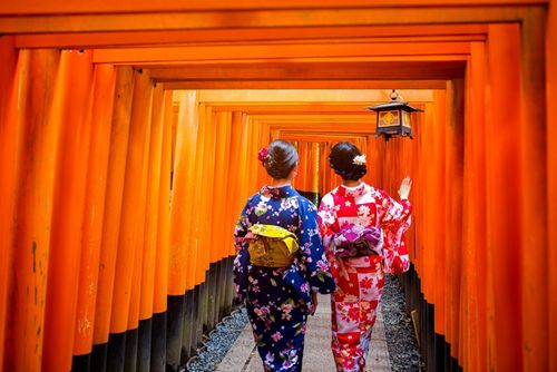
The Ainu
"…they are uncivilizable and altogether irreclaimable savages, yet they are attractive …I hope I shall never forget the music of their low sweet voices, the soft light of their mild, brown eyes and the wonderful sweetness of their smile."
Isabella Bird, Unbeaten Tracks in Japan, 1880.
Victorian traveller Isabella Bird had some misconceived notions about the Ainu, but anyone who has ever listened to their hauntingly beautiful music will agree that they are a people not easily forgotten. The Ainu’s roots are uncertain – some believe they come from Siberia or Central Asia, and they are thought to have lived on Hokkaidō, the Kuril Islands, Sakhalin and northern Honshū since the seventh century. The early Ainu were hairy, wide-eyed (even today you can notice such differences in full-blooded Ainu) and lived a hunter-gatherer existence, but their culture – revolving around powerful animist beliefs – was sophisticated, as shown by their unique clothing and epic songs and stories in a language quite unlike Japanese.
Up until the Meiji restoration Japanese contact with the Ainu in Hokkaidō, then called Ezochi, was limited to trade and the people were largely left alone in the north of the island. However, when the Japanese sought to fully colonize Hokkaidō, the impact on the Ainu was disastrous. Their culture was suppressed, they were kicked off ancestral lands, saw forests cleared where they had hunted, and suffered epidemics of diseases from which they had no natural immunity. Their way of life went into seemingly terminal decline and assimilation seemed inevitable after a law of 1899 labelled the Ainu as former aborigines, obliging them to take on Japanese citizenship.
Over a century later, against all odds, fragments of Ainu culture and society remain. Around 25,000 people admit to being full- and part-blooded Ainu (although the actual number is thought to be closer to 200,000). A tiny piece of political power was gained when Kayano Shigeru (1926–2006), an Ainu, was elected to the House of Councillors – the second house of Japan’s parliament – in 1994. A landmark legal verdict in 1997 recognized Ainu rights over the land and led to the New Ainu Law of 1997 which aimed to protect what is left of Ainu culture and ensure that it is passed on to generations to come. In 2008 Japan’s Diet also passed a resolution recognizing Ainu, for the first time in 140 years, as “an indigenous people with a distinct language, religion and culture”. Generally, there is more interest in and sensitivity towards this ethnic group from the Japanese who visit tourist villages such as Poroto Kotan and Akan-kohan. The best place to get an accurate idea of how Ainu live today is at Nibutani.
Worth seeking out for a broader understanding of the Ainu and their relationship to similar ethnic groups are the museums of Northern Peoples in Hakodate and Abashiri. The Sapporo-based Foundation for Research and Promotion of Ainu Culture produces the useful free booklet Payean ro, which outlines Ainu cultural facilities across Hokkaidō – it’s available at several tourist offices across the island.
Central Hokkaido
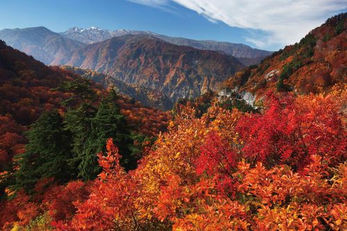
Daisetsu-zan, Japan’s largest national park, dominates central Hokkaidō with the island’s highest mountain, Asahi-dake, and the spectacular Sōunkyō Gorge. For 10-day Japan trips focused on Hokkaidō, this region offers a strong mix of mountain scenery, seasonal flowers, skiing, and city connections.
Southwest of the national park, the fields around the picturesque village of Bibaushi are at their best in summer, when lavender, sunflowers, and other blooms create a multicolored patchwork. Farther south, Furano is one of Japan’s top ski resorts and a location for World Cup skiing competitions.
Asahikawa, Hokkaidō’s second-largest city, serves as the area’s transport hub and offers a few worthwhile sights along with lively nightlife.
Asahikawa’s sake breweries
The pure waters flowing off Daisetsu-zan are one reason that Asahikawa has long had a flourishing sake industry. To sample some of the local product, head to the Takasago Sake Brewery (高砂酒造), set in a traditional wooden building around ten minutes’ walk east of Asahikawa Station. They’ve been making sake here since 1899 and from late January to early March they have a tradition of building an ice dome in which some of their sakes are fermented. If you have more time, head 6km north of the city centre to the Otokoyama Sake Brewery and Museum (酒造り資料館), where you can also taste the award-winning rice wines for free. Buses #67, #70, #71 and #667 from platform 18 in front of the JR station will get you here.
Daisetsu-zan National Park
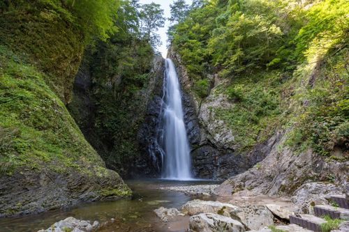
The 2309-square-kilometre Daisetsu-zan National Park (大雪山国立公園) offers a spectacular range of gorges, hot springs and mountains – including Asahi-dake, the island’s tallest peak – crisscrossed by hiking trails which could keep you happily occupied for days. Tourism in the park is generally low-key, especially at the wooded and remote Asahidake Onsen. Sōunkyō Onsen, on the northeast edge of the park, hosts the bulk of tourists, though a tasteful redevelopment has made it much more attractive than most hot-spring resorts. The highlight here is the gorge, a 20km corridor of jagged cliffs, 150m high in places. In July, the mountain slopes are covered with alpine flowers, while September and October see the landscape painted in vivid autumnal colours; these are the best months for hiking. During the winter, both Asahi-dake and Kuro-dake in Sōunkyō are popular skiing spots, enjoying the longest ski season in Japan (usually Oct–June).
Furano
Surrounded by beautiful countryside, Furano (富良野) is famous throughout Japan as the location of a popular soap opera Kita no Kuni Kara (From the Northern Country), about a Tokyo family adapting to life in Hokkaidō. The landscape evokes Provençal France, with bales of hay lying around and lone poplars etched against the peaks of Daisetsu-zan National Park. The busiest season is June and July, when vast fields of lavender and other flowers bloom, drawing visitors to the gently undulating countryside hereabouts – ideal for walks, cycling and photography; the most scenic farmlands surround the tranquil settlements of Kamifurano (上富良野), Biei (美瑛) and Bibaushi (美馬牛). In winter, Furano is known for its skiing.
The local tourism office is working hard to ensure that the Japanese character and charm of the area aren’t lost or overlooked by visiting gaijin. During the ski season a free cultural performance is held every Saturday night at the restaurant at the Kitanomine gondola station. This includes a presentation of the town’s “belly button dance”, the highlight of Furano’s Heso Matsuri (Navel Festival), held every July 28–29 and celebrating the town’s position at the centre of Hokkaidō.
Further afield, if you need goals for your perambulations head to Kamifurano where the Goto Sumio Museum of Art (後藤純男美術館) contains dreamy landscape paintings from one of Japan’s major contemporary artists, or to Furano’s wine and cheese factories. Furano and the outlying towns in the area can also be used as a base for a hike up the 2077m active volcano of Tokachi-dake, some 20km southwest and within the Daisetsu-zan National Park.
Fertile Furano
It’s not just flowers that thrive in Furano’s fertile soil. The area is also known for its melons, potatoes, onions, milk and grapes. At Chateau Furano, around 4km northwest of Furano Station, you can sip from a range of 18 different wines; some of them are fairly palatable. The obvious accompaniment is cheese, and this can be sampled at the Furano Cheese Factory (富良野チーズ工房), about 1km east of the New Furano Prince Hotel. Apart from selling concoctions such as a brie turned black with squid ink, this fun facility also allows you to practise milking a fake cow (¥100) and sign up for bread, butter-, cheese- and ice cream-making workshops (¥680–850).
Skiing in Furano
Furano’s winter focus is its ski resort on the slopes of Mount Kitanomine, a popular option with those seeking to escape the crowded foreigner scene at Niseko. The slopes are challenging, but not as varied or as long as Niseko’s; to go off-piste, or try backcountry skiing with qualified English-speaking guides, contact Hokkaidō Powder Guides.
Eastern Hokkaido
With three major national parks, eastern Hokkaidō will be a high priority for those interested in Japan’s natural environment. Public transport is sparse, so consider renting a car to get around. Abashiri is known throughout Japan for its old maximum-security prison (now a museum), and winter boat tours through the drift ice on the Sea of Okhotsk. Jutting into these inhospitable waters northeast of Abashiri is Shiretoko National Park, a UNESCO World Heritage Site and one of Japan’s most naturally unspoiled areas. Inland, south of the peninsula, the Akan National Park is also stunning, with hot springs and three scenic lakes. More eco-tourist delights await at Kushiro Shitsugen National Park and Kiritappu Marsh where you can spot regal red-crested cranes among many other fauna and flora.
Cranes, swans and eagles
Birdwatchers will be thrilled by eastern Hokkaidō. The area is home to three of Japan’s top four ornithological spectacles: red-crested white cranes (tancho-zuru) in the Kushiro and Kiritappu regions; whooper swans, also in the Kushiro region, and near Abashiri and Odaito towards the Notsuke Peninsula; and Steller’s sea eagles at Rausu on the Shiretoko Peninsula. The fourth must-see is cranes at Arasaki in Kyūshū. The best months to view all of these are January, February and March.
The red-crested white cranes, commonly called tancho, are a symbol of Japan and were once found all over the country. However, they became so rare in the twentieth century that they were thought to be almost extinct. Fortunately, the birds – designated a “Special Natural Monument” in 1952 – have survived and their population, living exclusively in eastern Hokkaidõ, now numbers around one thousand. Thanks to feeding programmes at several sites around the Kushiro Shitsugen National Park, it’s possible to see these grand but shy birds; with a 2m wingspan they are the largest in Japan.
The disputed Kuril Islands
A protracted territorial dispute over the Kuril Islands, some of which can be seen clearly from the Shiretoko Peninsula, means that technically Japan and Russia are still fighting World War II. A peace accord has yet to be signed because of Russia’s continued occupation of these volcanic islands, which are strung across the Sea of Okhotsk between the Kamchatka Peninsula and northeastern Hokkaidō.
Known in Japan as the Northern Territories, or Chishima (Thousand Islands), and in Russia as the Kurils, only five of the islands are permanently inhabited. Japan demands the return of the four southernmost islands of Kunashiri, Shikotan, Etorofu and the Habomai group, the closest of which is less than 20km off Hokkaidō’s coast. The islands themselves are fairly desolate; it is their strategic importance, rich mineral resources and the surrounding fishing grounds that make them so desirable.
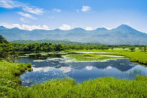
Kushiro Shitsugen National Park
Japan’s largest protected wetland, at 45,200 acres, is the Kushiro Shitsugen National Park (釧路湿原国立公園). Birdwatchers flock here in winter to see tancho cranes, but the wetlands are home to many other birds and animals, including deer, grey herons, whooper swans and eagles.
One of the best places to observe the cranes is actually just north of the park, in the fields near the village of TSURUI (鶴居), an hour’s drive north of Kushiro, at the Tsurui Itō Japanese Crane Sanctuary (鶴居•伊藤タンチョウサンクチュアリ). Half an hour further north of here towards Akan, the Akan International Crane Centre GRUS has breeding facilities and an interesting exhibition hall.
Shiretoko National Park
Since 176,000 acres of the Shiretoko Peninsula, including the Shiretoko National Park (知床国立公園), gained UNESCO World Heritage Site status in 2005, there’s been an increasing amount of investment in, as well as visitors to, this magnificent ecosystem 42km east of Abashiri. Even so, by any standards the park, which covers about half the 70km-long peninsula thrusting into the Sea of Okhotsk, remains virtually untouched by signs of human development: there are few roads or tourist facilities and wildlife is abundant – you’re almost guaranteed to encounter wild deer, foxes and even brown bears. Peak season is from June to September, the best period for hiking and viewing the five small lakes at Shiretoko Go-ko, most easily reached from the peninsula’s main town Utoro. In the winter, drift ice litters the shore, and some 2000 Steller’s sea eagles can be observed near RAUSU (羅臼) on the peninsula’s southeast coast. This remote fishing village has fewer facilities than Utoro but can still be used as a base for touring the park; it’s the only place offering cruises in winter too – try Hamanasu Kankō.
Beware bears
The brown bear (ezo higuma) is common to wilderness areas of Hokkaidō, with around 200 thought to be living in the Shiretoko-hantõ. The bears, which can grow to a height of 2m and weigh up to 400kg, can be dangerous if surprised. If you’re planning a hiking trip in these parts, it is important to be alert for bears and take appropriate precautions so you don’t disturb them. Carrying a bell that jangles as you walk is a good idea as this will warn bears of your approach and hopefully keep them away. It’s also vital, if carrying food, that you take great care to keep this away from bears. Don’t discard food scraps around where you camp – leave them until you reach a river or stream where they can be washed away. If you do encounter a bear, don’t run away – this will be an invitation for them to chase you – and don’t make any sudden movements or look them directly in the eyes. Try to remain as still as possible until the bear gets bored and moves on.
Hiking in the Shiretoko National Park
The peak of Rausu-dake (羅臼岳), the tallest mountain in Shiretoko at 1661m, can be reached in around four-and-a-half hours from the Iwaobetsu Youth Hostel, passing a natural rotemburo on the way. From the summit there are spectacular views along the whole peninsula, and to the east you should be able to see Kunashiri-tō, one of the disputed Kuril Islands, or “Northern Territories” as they are known in Japan. It takes a full day to continue across Rausu-dake to Rausu.
Iō-zan (硫黄山), the active volcano that produces hot water for the Kamuiwakka-no-taki waterfalls, is a more difficult climb. The trail begins beside the Shiretoko Ōhashi, the bridge just beyond the entrance to the falls. A hike to the 1562m summit and back takes at least eight hours and can be combined with a visit to the hot waterfall.
You’ll need to be a serious mountaineer to tackle the difficult ridge trail linking Iō-zan and Rausu-dake; bring a topographical map, take precautions against bears and plan to stay one or two nights at the campsites along the way. The Rusa Field House (ルサフィールドハウス), about 10km north along the coast from Rausu, can provide rules and current information to mountaineers and sea kayakers.
Shikotsu-Tōya National Park
Follow the coastal road or rail line around Uchiura-wan from Hakodate and you’ll reach the eastern side of the Shikotsu-Tōya National Park (支笏洞爺国立公園), one of Hokkaidō’s prettiest lakeland and mountain areas, but also the most developed, thanks to its proximity to Sapporo, some 80km to the north. Both the park’s two main caldera lakes – Tōya-ko to the east and Shikotsu-ko to the west – have gorgeous locations, are active volcanoes and are surrounded by excellent hiking trails. Between the two lakes lies Noboribetsu Onsen, Hokkaidō’s largest hot-spring resort, worth visiting to soak up the otherworldly landscape of bubbling and steaming Jigokudani (Hell Valley).
Birth of a volcano
On December 28, 1943, severe earthquakes began shaking the area around Usu-zan and continued to do so until September 1945. In the intervening period a new lava dome rose out of the ground, sometimes at the rate of 1.5m a day. By the time it had stopped growing, Shōwa Shin-zan, the “new mountain” named after the reigning emperor, stood 405m above sea level. The wartime authorities were desperate to hush up this extraordinary event for fear that the fledgling mountain would serve as a beacon for US bomber planes.
Fortunately, Shōwa Shin-zan’s daily growth was carefully documented by local postmaster and amateur volcanologist Mimatsu Masao. After the war, Mimatsu bought the land on which the mountain stood, declaring, “I purchased the volcano to continue my research uninterrupted. I did not buy it to make money. Nor did I buy it for tourists to gawk at.” His efforts were rewarded in 1958 when Shōwa Shin-zan was made a Special Natural Treasure by the government.
Nevertheless, Mimatsu never turned away tourists – but nor did he charge them admission, a practice still upheld. The Mimatsu Masao Memorial Hall (三松正夫記念館), tucked behind the ghastly row of gift shops at the base of the volcano, contains an interesting collection of exhibits on the history of the fledgling volcano.
Noboribetsu Onsen
East around the coast from Tōya-ko, and nestling amid lush green mountain slopes ripped through by a bubbling cauldron of volcanic activity, is Noboribetsu Onsen (登別温泉). Hokkaidō’s top hot-spring resort may be peppered with lumpen hotel buildings and tacky souvenir shops, but its dramatic landscape is definitely worth seeing and there’s ample opportunity for some serious onsen relaxation.
Shikotsu-ko
Tourist development around the beautiful lake of Shikotsu-ko (支笏湖) is remarkably low-key, despite this being the closest part of the park to Sapporo. At 363m, this is Japan’s second-deepest lake (after Tazawa-ko in Akita-ken), and its blue waters never freeze over. All buses stop at the tiny village of Shikotsu-ko Onsen (支笏湖温泉), nestled in the woods beside the mouth of the Chitose-gawa on the east side of the lake, and mercifully free of the multistorey hotels present at Tōya-ko.
Hiking routes
One of the easiest trails starts at the northern end of the village and leads up Monbestu-dake (紋別岳; 866m), which takes around one hour and twenty minutes to climb. The hike up Eniwa-dake (恵庭岳; 1319m), on the north side of the lake above the Poropinai campsite, is more challenging and takes at least two and a half hours; staff at the visitors’ centre advise only climbing to the Miharashi-dai, beneath the 1319.7m summit, because the trail to the top can be dangerous. After this climb, you could unwind beside the lake at the foot of the mountain in the lovely rotemburo at Marukoma Onsen.
Most people, however, opt to climb Tarumae-zan (樽前山), an active volcano (the last eruption was in 1951) south of the lake. The hike begins at the seventh “station”, three-quarters of the way up the volcano at the end of a dirt road; the easiest way of reaching the start is to hitch a ride from Shikotsu-ko. The walk from the seventh station up to the summit (1041m) shouldn’t take more than an hour. At the top, the pungent aroma from the steaming crater discourages lingering. Following the northwest trail down from Tarumae-zan towards the lake leads, after a couple of hours, to the moss-covered gorge of Koke-no-dōmon (苔の洞門); sadly, erosion at this site means that you’ll only be able to view the soft green velvet rock walls from a distance. From here it’s a 14km hike back to Shikotsu-ko Onsen.
Tōya-ko
The beautiful caldera lake of Tōya-ko (洞爺湖) is punctuated dead centre by the conical island of Nakajima. Its southern shore is home to the tired-looking resort Tōya-ko Onsen (洞爺湖温泉), where you’ll find most accommodation and local transport connections. Between April 28 and October 31 spectacular fireworks (nightly 8.45–9.05pm) illuminate the lake. Pretty as the location is, the best reason for visiting Tōya-ko is to see the nearby active volcano Usu-zan (有珠山), around 2km south, and its steaming “parasite volcano” Shōwa Shin-zan (昭和新山).
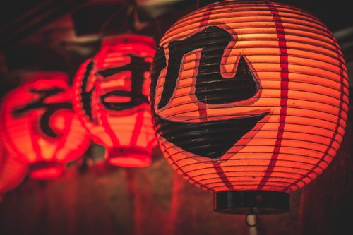
Top image © Charlie Wood/Shutterstock
 (1).jpg)