Morsárdalur
Morsárdalur is a 10 km long, flat bottomed glacial valley west of the Skaftafellsheiði plateau, and a rewarding detour on the South Coast and Westman Islands Iceland trip if you want quieter trails in Southeast Iceland. You can reach it either by following paths from Svartifoss or by taking the flatter route directly from the Visitor Centre. A highlight is Bæjarstaðarskógar, a small grove of willows and birch near a sublime geothermal pool that’s just large enough for two.
To extend the walk, continue deeper into Morsárdalur, then bear west in front of the small Morsárjökull glacier toward Kjós, a striking canyon of broken boulders and sharp yellow ridgelines.
Skaftafellsheiði Plateau Circuit
A rewarding, 6hr trail circuits the moors atop the Skaftafellsheiði plateau. Note that cloud, rain and fog can move in quickly, and you’ll need Mál og mennings’ 1:100,000 Skaftafell map, which has a 1:50,000 detail covering the Skaftafellsheiði area.
Beginning at Svartifoss, aim for Sjónarsker, a stony 310m ridge where the upper trail to Morsárdalur diverges – it makes a good general orientation point, as you can see from the coast right up to Vatnajökull from here. Heading due north the path weaves through knee-high birch thickets, silent except for bird calls, towards Skerhóll’s steep front, and then climbs the gently sloping rear of this platform. Next comes a short ascent up to Nyrðrihnaukur, a long grassy crest from which you can spy down on Morsárdalur’s spread of crumbly grey cliffs, flat valley floor with intertwined streams, and encroaching glaciers.
By now you’re about two hours from Svartifoss, right at the foot of Kristínatindar, a scree-covered peak rising 1125m to a jagged set of pinnacles. One trail heads eastwards around its south side, but you can also follow unmarked trails over Kristínatindar itself, starting from where the main path curves into a “bowl” between the two main peaks – the ascent is nowhere near as hard as it looks, though tiring enough. You emerge onto an icy saddle, the wind suddenly tearing into your face, with the main peak on your left and the minor summit to the right. The mountain is surrounded on three sides by ice, its wedge-like spine splitting Vatnajökull’s outflow into the two glaciers which run either side of it – eastern Skaftafellsjökull is closer, a broad, white ribbon, crinkled and ribbed by the vast pressures squeezing it forward. The trail heads down towards it – you have to cast around to find the steep, indistinct track – landing you at Gláma, at the top of the sheer-sided valley filled by Skaftafellsjökull, where the trail meets the marked track around Kristínatindar. From here, you simply follow the stony cliff edge for an hour or so south to Sjónarnípa, a vantage above the glacier’s front, where the path continues along the edge back to the campsite via birch scrub at Austurbrekka.
Skaftafellsjökull
One of Skaftafell’s shortest walks, and a rewarding stop on the Iceland East-to-West trip, runs from the Visitor Centre to the front of Skaftafellsjökull itself. It’s an easy 30 minute walk through low scrub beneath yellow cliffs. The trail ends at a pool and stream fed by glacial meltwater, beyond which lie ice shattered shingle and the glacier’s front, streaked with mud and grit.
Look out toward the sea to see how far the glacier has retreated, leaving gravel ridges known as moraines. Do not step onto the glacier, as hidden crevasses and unstable ice make it extremely dangerous.
Tip from Rough Guides: Learn about the best ways to get to Iceland.
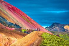
Top image: Skaftafell glacier, Vatnajokull National Park in Iceland © Guitar photographer/Shutterstock