Travel advice for Namibia
From travel safety to visa requirements, discover the best tips for visiting Namibia
Plan and book your private, tailor-made tour with vetted local experts
Namibia is one of those places that changes how you think about space. Everything feels bigger here - skies, landscapes, even the quiet. Driving for hours through desert or along the Skeleton Coast isn’t just part of the trip, it is the trip. It’s the kind of country where getting between destinations becomes its own experience.
Distances are long, roads are often gravel, and many of its most spectacular places (the dunes of Sossusvlei, Etosha’s salt pans, the Skeleton Coast) sit hundreds of miles apart. It’s part of what makes Namibia so remarkable: the feeling of being surrounded by pure wilderness, with almost no one else around. But it also means you’ll want a solid itinerary as good planning makes all the difference.
Travel here isn’t difficult, but it does require forethought to make the most of it. Here’s a round up of our favorite Namibia itineraries. Or, if you’d like a hand, our local travel experts can plan and book your Namibia trip from start to finish. They’ll help navigate the distances, choose the right lodges, and create a route that fits exactly how you like to travel.
Most visitors to Namibia opt for 7, 10, or 14-day itineraries to balance the country's vast distances with meaningful experiences at each destination. Self-drive adventures are popular for their flexibility, while guided tours offer deeper insights into this fascinating country's ecology and culture.

Tips from Stephanie
Namibia Travel Expert

When visiting Namibia, don't miss trying our traditional kapana. These are grilled meat strips seasoned with salt and spices that you'll find at local markets in Windhoek and northern towns. Game meat dishes featuring oryx, kudu, or springbok are also some unique flavors you probably can't experience anywhere else. They're leaner than beef with a mild, earthy flavor. For breakfast, be sure to try oshifima (maize porridge) or vetkoek (fried dough bread).
Want to make your trip stress-free? Our Namibia local travel experts can guide you.

Sossusvlei dune, Namibia © elleon/Shutterstock
How to plan a trip to Namibia that's only a week long? This 7-day Namibia itinerary makes the most of the limited time you have and takes you through some of Namibia’s most dramatic landscapes and best-known wildlife areas. It brings together a range of ecosystems, from the sand dunes of the south to the rocky desert up north.
Travel time: About 1 hour 15 minutes by plane
This Namibia itinerary kicks off with a flight from Windhoek into the Namib Desert. Most flights use small bush planes and land at either the Sossusvlei or Geluk airstrip. From the air, it’s just dune after dune, stretching in every direction. Most people stay in a lodge right by the sand sea, which makes it easy to head out for a scenic drive later in the day.
You might come across oryx, springbok, and other desert animals. In the evening, it’s worth taking time outside to look up. This part of Namibia has some of the clearest night skies around.
Insider tip: Bring a warm layer. Once the sun goes down, the temperature can drop more than 35°F (20°C).

You’ll want to your alarm early on day two of this Namibia itinerary. This is the day you’ll head into Namib-Naukluft National Park, part of the Namib Sand Sea. Your guide will take you through a through a valley lined with dunes that rise over 1,000 feet (300 meters), including some of the tallest in the Namib.
This area is part of the UNESCO-listed Namib Sand Sea, and it’s where you’ll find the famous Deadvlei, with its white clay pan and 900-year-old trees. If you’ve got the energy, climbing Big Daddy (about 1,050 feet / 325 meters tall) is the way to get a full view of the dunes and surrounding plains. Later in the day, take a walk into Sesriem Canyon, a narrow gorge carved out by flash floods. It’s cooler in the shade and gives you a different look at the desert.
Travel time: 2 hours flight
Today’s flight takes you north, over changing terrain that shifts from desert dunes to rocky hills and wide gravel plains. You’ll probably fly in a small plane like a Cessna Caravan, landing near Twyfelfontein.
After you land you, can arrange for a lodge-based guide to meet you, or coordinate a pickup through a local operator in advance. There’s no public transport here, so you’ll need to sort this part before you arrive.
The scenery changes completely here. Damaraland is dry, dramatic, and full of surprises. Expect long views, strange rock formations, and a few animals that have adapted to life without much water. You’ll do a guided drive through the area and maybe take a short walk to learn more about the plants and smaller creatures that manage to survive here. The day usually ends around the fire or at an outdoor dinner, with the jagged Etendeka Mountains silhouetted against the stars.
Insider tip: Keep binoculars within reach. The land is wide open, but wildlife can be hard to see without some help.

This is one of the most memorable days of this Namibia itinerary. You’ll head out with trackers from Save the Rhino Trust who are monitoring black rhinos in the Palmwag Concession, a protected area of about 1,740 square miles (450,000 hectares). You’ll travel in a vehicle at first, then possibly go on foot if the rhinos are nearby. It’s quiet, careful work, but being able to watch these animals in the wild is something special.
In the afternoon, you can hire a local guide again to take you out to look for other desert-adapted species. Elephants here can walk over 45 miles (70 km) a day in search of water. There’s a chance you’ll also come across Hartmann’s mountain zebra. On rare occasions, people do see desert lions, but sightings aren’t guaranteed.
Insider tip: Ask the trackers how they tell individual rhinos apart. They’ll point out details like horn shapes and scarring.
Travel time: 1 hour 30 minutes flight
You’ll start early on day five of this Namibia itinerary with a short sunrise walk around camp. Light comes fast in Damaraland, and the air’s still cool. After breakfast, you’ll board a small plane, usually a Cessna, for the 1.5-hour flight west. Sit on the left if you want better views. You’ll watch the landscape shift from rocky ridges to rolling sand dunes, and eventually to a pale strip of Atlantic coast.
You can land at Möwe Bay or near Shipwreck Lodge, depending on where you're staying. From there, plan on spending the afternoon out in the Hoanib River valley. It looks dry, but it’s a key wildlife corridor. You’ve got a good chance of seeing desert elephants digging for underground water, and possibly gemsbok, springbok, or even desert lions if you’re lucky.
Insider’s tip: Salt from the ocean air can ruin your gear. Keep your camera zipped away when you’re not using it.

You’ll want a full day to explore deeper into the southern concession. Mudorib Springs is a good goal. Animals tend to gather there, especially Hartmann’s mountain zebra, desert-adapted rhino, and a handful of antelope species. Most of the day will be spent navigating the northern and eastern arms of the Hoanib, where desert elephants roam. They’ve adapted to this terrain with wide feet and a surprising ability to find water where nothing seems to grow.
Insider’s tip: Wind can pick up without warning. A scarf or buff will help keep sand out of your nose and mouth.
If you have time, build in a full-day 4x4 drive out to the Atlantic. You’ll follow the Hoanib all the way to the ocean, passing through floodplains and springs like Klein Oases along the way. The landscape shifts again as you approach the coast. Fog rolls in, and the sand gets colder, quieter. You’ll start to see old shipwrecks half-buried in dunes.
At Möwe Bay, you can stop to see the seal colonies. Thousands of Cape fur seals crowd the shore, noisy and packed together. After that, it’s possible to take a flight back over the coastline. You’ll see wrecks, waves, dunes, and the long line where desert meets sea.
Want to see Namibia but are overwhelmed by the details of planning? Our local travel experts are local to the area and can help you to create a personalized itinerary.

This self-drive route gives you ten days to take in some of Namibia’s best-known places while still leaving time to enjoy quieter moments along the way. With your own vehicle, you'll move at your own pace, climbing dunes in Sossusvlei, watching wildlife in Etosha, and sleeping under the stars near ancient rock formations. You’ll need a sturdy car, a full tank, and a bit of patience.
You’ll land in Windhoek, Namibia’s small, manageable capital, surrounded by low mountain ridges. After picking up your rental car at the airport (something like a Toyota RAV4 works well), drive into town and get settled. Stretch your legs with a walk down Independence Avenue where a few old German buildings still line the street. If you have the energy, the National Museum is worth checking out. It helps put a lot of what you’re about to see into context.
Insider tip: Grab a SIM card from MTC at Maerua Mall before you head out of town. It makes navigation and staying connected way easier in the more remote areas.
Travel time: 5 to 6 hours
Take the C26 route west out of Windhoek, through the Khomas Hochland, then drop down into the desert. Spreetshoogte Pass is a good place to pull over and take in the view. Eventually, you’ll reach Sesriem, the little gateway town near the dunes.
That night, you can join a short night walk with UV lights to spot scorpions and other desert creatures. It might sound gimmicky, but it’s actually pretty fascinating to see what’s crawling around after dark. The desert feels like a different place at night.
Insider tip: Fill your tank in Windhoek and again in Solitaire. You won’t pass many gas stations once you’re deep into the Namib.

You’ll want to wake up early to get into the park right when the gates open. The colors on the dunes change fast as the sun comes up. If you’re up for it, climb Dune 45. It’s not long but the sand makes it a workout.
Deadvlei is the real standout here. You’ll walk across cracked white clay to a dry pan full of long-dead trees. It’s quiet, a little eerie, and weirdly beautiful. Try to get out before the midday heat kicks in. It builds fast.
Insider tip: Bring at least 3 quarts (3 liters) of water per person, wear closed-toe shoes, and keep an eye on the heat. The sand gets hot quickly.
Travel time: 5 hours
On day four of this Namibia itinerary, head northwest toward the coast. You’ll pass through gravel plains and stop in Solitaire for fuel and a slice of apple pie (they’re known for it). The drive gets flatter and dustier as you go.
In Walvis Bay, the lagoon is worth a quick visit. You can see flamingos and other birds feeding in the shallow water. From there, it’s another half hour up the coast to Swakopmund. After days of dry desert heat, you hit this patch of cool air and sea fog. The cold Benguela Current keeps the town cooler year-round, so while it’s baking inland, you’ll probably need a jacket here.
German colonial buildings stand out with pointed rooftops, pastel paint, even a few half-timbered houses. But they’re surrounded by more everyday Namibia: informal vendors, modern supermarkets, and local shops.
Insider tip: Try fish and chips from the jetty or one of the local takeaways. There’s also a mix of German bakeries and pan-African food spots if you look beyond the tourist-facing restaurants.

Travel time: 2.5 hours
In the morning, head with a guide to Sandwich Harbour. It’s one of the only places in the world where massive dunes drop straight into the ocean. You’ll need a proper 4x4 and a guide who knows the tides. This stretch of beach gets cut off fast.
After lunch, drive inland toward Spitzkoppe. It’s about 2.5 hours across flat desert, with gravel plains with barely any vegetation. Then, without warning, a cluster of huge granite peaks starts rising from the landscape.
It’s not a mountain range, exactly, but a group of ancient volcanic rock formations that have been weathered into dramatic arches, domes, and jagged peaks. The tallest one reaches nearly 5,700 feet (1,740 meters). People sometimes call it “Namibia’s Matterhorn,” but that’s more about shape than scale.
There are San rock paintings in the caves, natural rock pools if it’s rained recently, and hiking routes across the boulders.
Insider tip: Try to camp on the east side of the rocks. You’ll have less wind and a clear view of the moonrise.
Travel time: 6 to 7 hours
Start the day early with a walk among Spitzkoppe’s boulders. A local guide will lead you to some of the rock art sites hidden in the stone. Some of these paintings are thousands of years old. You’ll hear a bit about the San people’s beliefs and how they used the landscape around them.
From there, you’ll head north. The road toward Etosha passes through Outjo, where it’s possible to arrange a short visit to a Himba community. The Himba are an Indigenous pastoral group with a distinct way of life, known for their ochre-covered skin and semi-nomadic cattle herding.
In the Kaokoland and Kunene region, some lodges and tour operators offer visits, usually half-day or shorter, often in coordination with Himba guides from the community. Having a local guide helps with translation and gives more context to the visit, but it’s worth asking how the partnership is set up to make sure it’s respectful and not exploitative.

Plan for a full day in the park. If you’re self-driving, it’s worth getting up before sunrise. That’s when predators are more likely to be on the move. Enter early and take it slow. Giraffes are often visible above the trees, and zebras tend to move in groups along the roads. Elephants come and go depending on waterholes. You might get lucky with a rhino.
In the afternoon, pull into Okaukuejo and park at the waterhole. Animals usually pass through as the heat drops, so it’s worth settling in and watching. It’s a good time to rest and let the wildlife come to you.
Insider tip: Keep doors locked and windows up when you’re near waterholes. Elephants sometimes approach cars, and baboons are quick to test handles.
Travel time: 3 hours
Leave Etosha through the east gate and head south toward Waterberg Plateau. This is one of the more geologically distinct places in Namibia. It's a massive table-top mountain that rises around 650 feet (200 meters) above the flat Kalahari plains. The plateau has its own microclimate and supports plant and animal species you won’t find in the drier areas.
It’s also a conservation zone. The plateau acts as a refuge for endangered wildlife like black rhino, roan antelope, and sable antelope, which are hard to see elsewhere. The animals here are protected from poaching and not always visible from the trails, but the environment is rich and worth exploring.
Once you arrive, check in at the rest camp or lodge, then head out for an afternoon hike. There are marked trails leading to the top of the plateau, where you’ll get wide views across the surrounding plains.
Insider tip: This is also a great birding area, with species like Rüppell’s parrot.

Travel time: 3.5 hours (174 mi / 280 km)
Before you leave Waterberg, consider a guided nature walk along the base of the cliffs. The trails here are quieter in the mornings, and that’s when you’re more likely to see wildlife. You might catch baboons coming down from the rocks, and small antelope grazing in the open. The mix of forest and dry savanna creates a good balance of shade and visibility.
Back on the road, head south to Windhoek. If you have time, stop at the Cheetah Conservation Fund near Otjiwarongo. This isn’t a tourist center but an active conservation project focused on saving wild cheetahs. They run outreach programs with local farmers, study genetics, and take care of cheetahs that can’t return to the wild. Visitors get a closer look at a few of these ambassador animals and learn how conservation works on the ground.
From there, continue through the central highlands into Windhoek. The landscape becomes hillier and greener as you approach the capital.
If your flight leaves later in the day, you can still see a few things before heading to the airport. One easy stop is Heroes’ Acre, a national memorial about 10 miles (16 kilometers) south of Windhoek. It honors those who fought for Namibia’s independence and has a sweeping view of the surrounding hills.
Before you drive out, stop at the Namibia Craft Centre in central Windhoek. It’s in a former brewery and sells crafts from all over the country. You’ll find carved wooden bowls, woven baskets from the north, and textiles made by cooperatives. It’s a good way to support artists directly and get something that doesn’t feel mass-produced.
Wondering how to plan your trip? Our local travel experts design itineraries just for you.

This route takes you deep into Namibia’s desert interior, from dry grasslands and red sand dunes to coastal fog banks and the edge of a salt pan the size of a small country. Distances are long and the roads are often gravel, but they’re quiet and well-maintained. The real work is in pacing the trip, as in, giving yourself time to adjust, stop often, and stay longer where it counts. You can expect early mornings, dusty boots, and long drives that are part of the experience.

Land in Windhoek, clear customs, and head to the rental desk. Most flights arrive mid-day, which gives you enough time to grab your 4x4 and make the 3- to 4-hour drive southeast. Once you get out of town, the roads open up fast. You’ll pass low brush, flat farmland, then the sand starts to shift red as you approach the Kalahari.
It’s a good introduction to driving in Namibia. The roads are gravel but manageable, with almost no one else around. The Kalahari isn’t a sea of dunes like the Namib, but the color of the sand is unmistakable. You’ll notice it in your shoes almost immediately.
When you reach your lodge, settle in and stay up for sunset. You’ll sleep early tonight.
Insider tip: Always go for high clearance. You don’t need full 4WD unless you’re doing deep sand, but clearance helps on washboard and uneven tracks.
Mornings are quiet here. Even in high season, you might not see anyone else on the trails. Join a guided walk through the reserve. You’ll move slowly, stopping often as your guide points out beetle tracks or digs into a puff of sand to reveal a burrow. Out here, the survival strategies are subtle. Everything is small, hidden, adapted to drought.
Later, drive across the reserve and look for animals like oryx, springbok, and giraffe, usually scattered in small groups near tree clusters.
In the late afternoon, you can book a guided visit to a San community based in the region. These are not living museums; they’re working communities that sometimes invite visitors to learn about fire-making, bow-hunting, and tracking. It’s low-key and respectful. Make sure the visit is through the right channels are benefit the community.
Insider tip: Take it slow when driving across the reserve. Wildlife often stands just off the track, and the light at the end of the day makes it easy to miss smaller animals like steenbok or jackals.

Travel time: 4 to 5 hours
Leave early for the drive south. You’ll follow the C14 to Mariental, then cut southwest on the B1 and B4. It’s mostly tar with long stretches of gravel. This is when you start to notice Namibia’s scale. Towns are far apart. Roads are straight for miles.
Stop in Keetmanshoop for fuel and supplies, then take a short detour to the Quiver Tree Forest just outside town. The trees are actually aloes and the area has a strange, sculptural look. From here, continue toward Fish River Canyon. You’ll arrive in the late afternoon.
After checking in to your lodge near the canyon, head out on a nature drive. Gondwana Canyon Park is huge and quiet, with wide gravel tracks leading to viewpoints and watering holes. You’ll pass through dry plains and scattered granite boulders. If you’re lucky, you’ll see Hartmann’s mountain zebra or kudu in the distance, but the real draw is the canyon itself.
You’ll spend day four of this Namibia itinerary with another day in Fish River Canyon. It’s the second largest in the world by some estimates; about 100 miles (160 km) long, up to 1,800 feet (550 meters) deep.
Wake early and walk the rim trail before breakfast. It’s not a long hike, but the ground is uneven, so watch your footing. Early in the day, it’s usually quiet enough that you can take in the scale of the canyon without distraction.
After breakfast, take a guided canyon drive. These reach viewpoints that aren’t accessible by rental car, and the guide will explain the geology—the slow folding, the layers of sediment, the movement of the Fish River over time. In the afternoon, drive down to Ai-Ais, a thermal spring at the bottom end of the canyon. The pool is outdoors and naturally heated.

Travel time: 5 to 6 hours
From the canyon, head northwest to Lüderitz via the B4. This is one of the most remote-feeling stretches of the trip. You’ll cross flat desert plains, then hit the Diamond Restricted Area boundary where access is controlled. Before that, stop at Garub to try and see the desert horses. Some days they’re near the waterhole.
From here, continue toward the coast. Fog often rolls in by afternoon, pushed in from the Atlantic. The landscape changes again. No more red sand, just gravel plains and a chill in the air you haven’t felt since Windhoek. Stay in Aus as your base.
Travel time: 4 to 5 hours
On day six of this Namibia itinerary, you’ll explore Kolmanskop, an abandoned mining town that was built during the diamond boom in the early 1900s and then abandoned by the 1950s.
People here lived lavishly: imported champagne, marble bathtubs, even a bowling alley in the middle of the desert. Now it’s all quiet. Wind pushes sand through broken doorways. Wallpaper flakes off in sun-bleached patterns. It’s strange and cinematic.
Afterwards, begin the long drive northeast toward the Namib-Naukluft area. This is where you’ll spend the next couple of nights, near Sossusvlei or NamibRand Reserve.
The drive takes about 4 to 5 hours. You’ll follow the C13 and C27 through wide gravel plains, with the desert slowly becoming more dramatic. Dunes begin to appear in the distance. They’ll seem small at first, then much larger as you get closer to the heart of the Namib. Keep an eye out for oryx near the road.

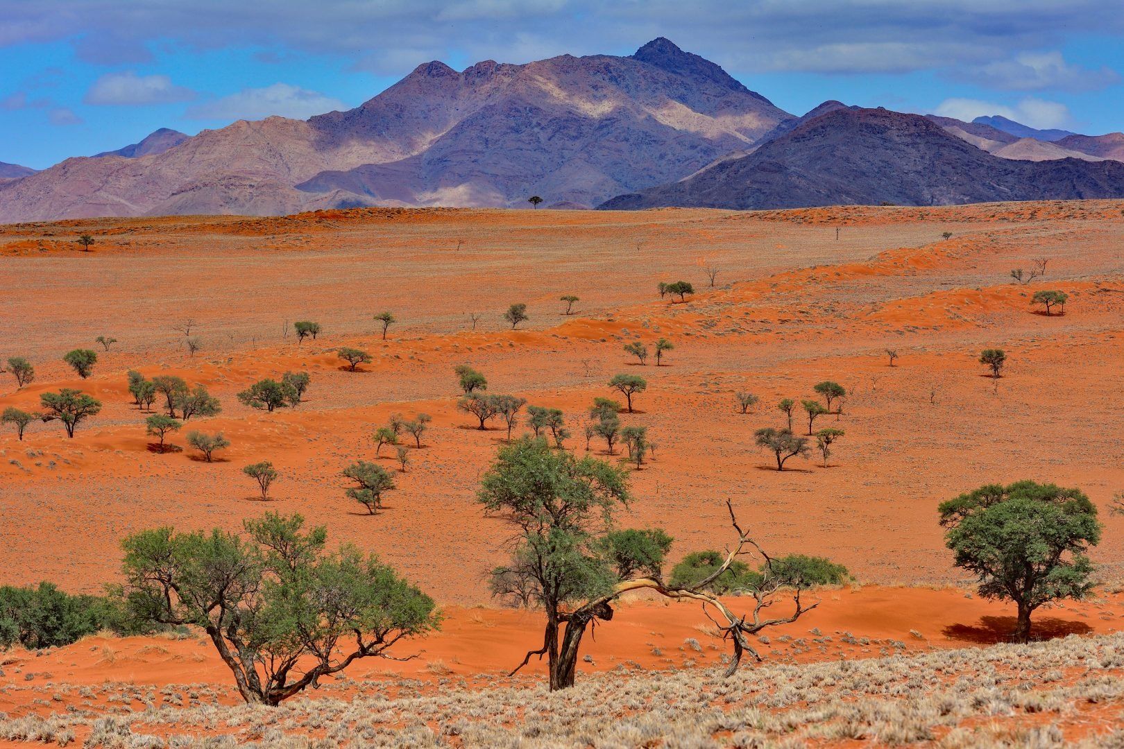
Waking up in the Namib feels like you’ve landed on another planet. This is one of the world’s oldest deserts, estimated at around 55 million years. The air is dry and sharp. Shadows stretch long in the morning. You’ll drive into the NamibRand Nature Reserve today, which covers over 500,000 acres (200,000 hectares) of protected desert. It’s private land, managed for conservation, with very low-impact tourism.
In the afternoon, hike up Elim Dune, a low ridge near Sesriem that’s easier to climb than the big ones further inside the park. From the top, you’ll get a clean view of the plains below, scattered with camelthorn trees and dry riverbeds.
Insider’s tip: The Namib’s “little five” often leave visible tracks just after dawn, especially after a windless night. Walk slowly and you’ll start seeing them everywhere. Look for little divots and scrawls left behind by geckos, beetles, or snakes.
Travel time: 5 to 6 hours
Park gates open just before sunrise, and you’ll want to be near the front of the line. The drive from Sesriem to the heart of Sossusvlei takes about 45 minutes. It’s paved the whole way, but you’ll transfer to a 4x4 shuttle or walk the last section through soft sand.
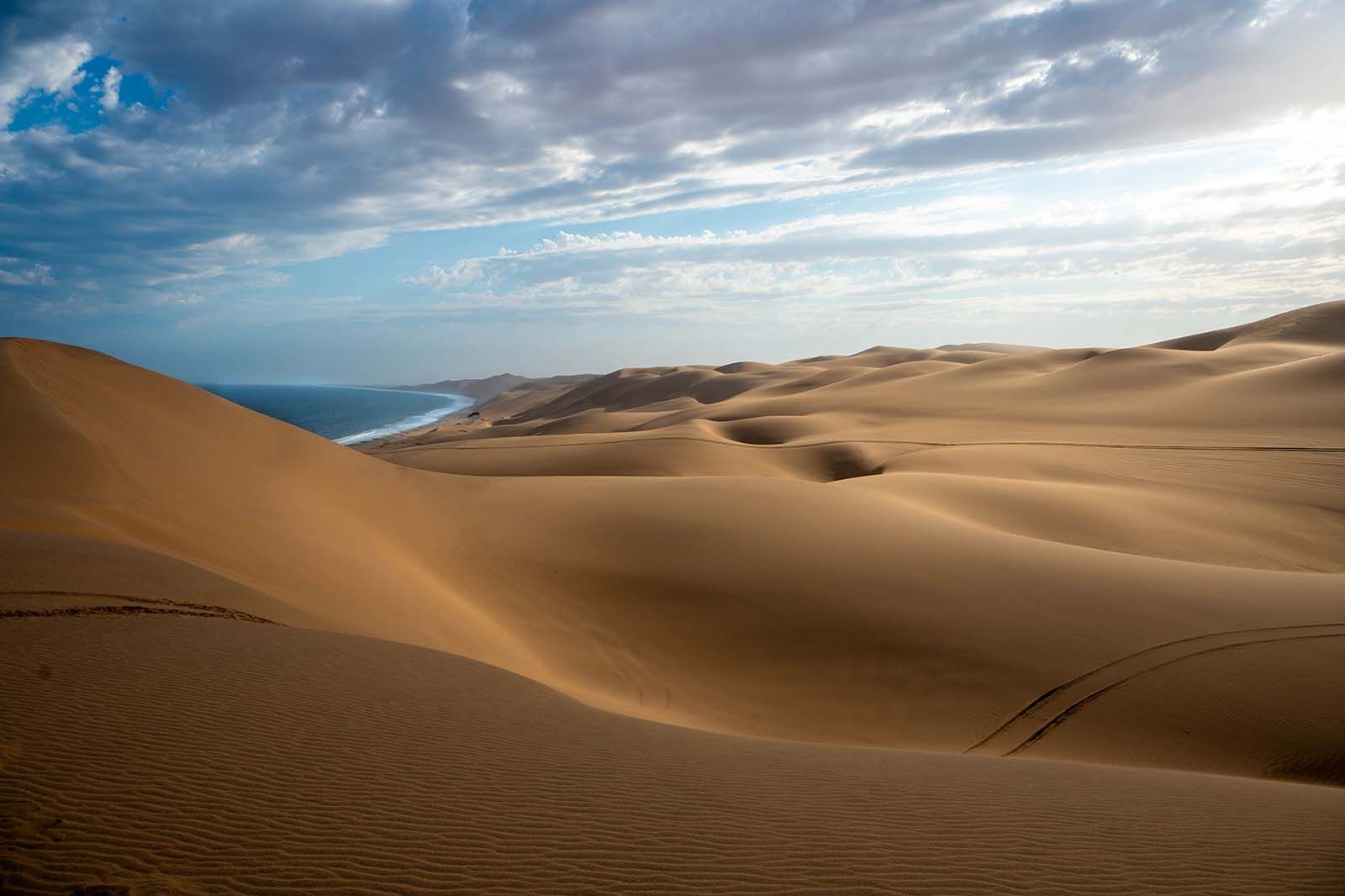
Climbing Big Daddy is tough. Even halfway up, though, the view is enough. From the ridge, you can look down into Deadvlei, a salt pan where 900-year-old dead trees still stand upright. There’s no water here anymore, the dunes shifted and cut off the flow, but the trees haven’t decayed. It’s so dry, they’ve been perfectly preserved.
By mid-morning, the heat kicks in, so it’s best to move on. The drive to Swakopmund starts across open gravel plains, then climbs through two dramatic passes: Gaub and Kuiseb. These canyons cut through billion-year-old rock formations. Keep an eye out for ostriches, oryx, and mountain zebras in the distance.
As you descend, the landscape flattens again. A thick band of coastal fog often greets you before you actually see the town.

Drive down to Walvis Bay in the morning of day nine of this Namibia itinerary. The lagoon is calm and shallow, and boat trips from here give you a chance to see how the desert meets the sea. Dolphins often swim alongside the catamarans. Cape fur seals sometimes leap onto the deck. Pelicans and flamingos feed in the tidal flats, especially near the salt pans where the water turns strange shades of pink and orange.
In the afternoon, head out in a 4×4 to Sandwich Harbour. This is where the dunes literally fall into the ocean. The road isn’t really a road, it’s actually shifting sand tracks between towering dunes and tide lines. Your driver will likely deflate the tires and adjust routes based on the tide. The climb to the viewpoints is steep but worth it. From the top, the ocean stretches one way, the desert the other. There’s no fence or barrier here.
Travel time: 5 to 6 hours
The road north from Swakopmund follows the coast along the C34. The inland drive brings a total change in atmosphere. Damaraland is dry, rocky, and wide open. You’ll pass through terrain carved by lava and time. Flat-topped hills, weird formations, endless sky. There’s no real grid here. The roads bend and dip with the land.
One of the main stops is Twyfelfontein, a UNESCO World Heritage site with thousands of rock engravings. These weren’t for decorations, they’re maps, stories, possibly teaching tools left by San hunter-gatherers. A local guide will usually walk with you, pointing out symbols and explaining what researchers think they mean.
Burnt Mountain and the Organ Pipes are nearby. Both shaped by volcanic activity millions of years ago, they look like something out of a geology textbook.

By this point in this Namibia itinerary, you’ve already crossed vast desert plains, climbed dunes, and driven past dry riverbeds lined with acacia trees. Damaraland feels different. It’s rough and quiet, with jagged mountains in the distance and long stretches of open land where you might not see another car for an hour.
Start your morning with a birding walk. It’s not fast-paced, but the birds here are unique to the region. Look out for the Herero chat and Monteiro’s hornbill.
Later, you’ll head out in search of desert-adapted elephants. These herds don’t move like the ones you see in Etosha. They follow ancient migration paths through dry riverbeds, digging for water and resting under mopane trees. You might drive for a while before seeing one.
In the afternoon, stop by the Damara Living Museum. It’s small and locally run, with a focus on traditional skills and daily life. You’ll get a chance to see how tools were made, how people stored water, and how they survived in this environment long before roads came through.
Travel time: 4 to 5 hours
The drive from Damaraland to Etosha follows the C39. It’s one of those drives where you gradually feel the environment changing. Around halfway, you’ll pass through Outjo, a small town with a few places to grab lunch and a grocery shop where you can restock before the park. Fuel up here if you’re low. After that, it’s an easy drive.
As soon as you pass through Andersson Gate, you’ll know you’ve entered a different world. The terrain flattens out into open grasslands, and animals start appearing quickly: springbok in clusters near the road, giraffes standing motionless by thorn trees, zebras kicking up dust as they move across the plain.
Drive slowly toward Okaukuejo Camp, where you’ll spend the night. The waterhole here is a key feature. It’s floodlit at night and draws animals throughout the evening. You don’t need to go far to see something remarkable. Just find a spot on the stone wall and wait. Elephants usually arrive after dark. Rhinos are quiet but unmistakable when they show up. You’ll likely hear jackals calling in the distance.

This is your full safari day in Etosha, so plan for an early start. The cooler morning hours are when predators are on the move, and the soft light makes everything easier to see.
You’ll spend most of the day on a slow loop eastward, stopping at waterholes (Halali and Namutoni). Some are wide open and easy to scan from the car. Others are more wooded, better for tracking movement between the trees.
At the heart of the park is the Etosha Pan, a vast, flat salt crust that stretches all the way to the horizon. You’ll probably only glimpse the edge of it, but it still makes the whole park feel bigger. If you’re visiting in the dry season, waterholes become even more important, and you’ll see animals gathering in large numbers wherever water remains.
Insider tip: If you stop near a waterhole and see lions nearby, keep your windows up. They’re curious and can get closer than you expect.
Travel time: 5 to 6 hours
When it’s time to leave Etosha, the B1 highway takes you back toward Windhoek. The route is straightforward, paved the whole way, and passes through a few towns worth a stop. Otjiwarongo is the first major one. Okahandja is further south and known for its open-air woodcarvers’ market. If you have space in your luggage, this is a good place to pick up a last souvenir.
Insider tip: Try to schedule a flight that leaves in the late afternoon or evening. That way, you won’t need to rush out of Etosha at sunrise, and you’ll have more flexibility if you run into traffic or want to stop en route.

Every trip to Namibia looks a little different, and that’s exactly how it should be. Our local experts create tailor-made routes based on what you want most out of the journey, from wildlife and desert landscapes to stargazing or learning about local cultures.
They’ll take care of every detail, including lodges, guided drives, and special experiences like a flight over the Skeleton Coast or dinner in a family-run guesthouse. Because distances are long and road conditions vary, having someone local to the area map out realistic routes and connections can make all the difference.
You’ll also have 24/7 in-country support throughout your trip, so you can relax and focus on what you came for: the quiet, the beauty, and the sense of space that makes Namibia so unforgettable. Ready to start planning? Get in touch with our Namibia local travel experts to create your personalized itinerary.

This two-week trip is designed with families in mind, with light adventure and experiences that keep kids curious and engaged. You’ll cover a lot of ground, but there’s a good rhythm that allows time to settle in and enjoy each stop.

This route gets you off the main tourist trail and into the far north of Namibia, with time to experience both dry desert and lush river landscapes.

If you're coming to Namibia for the stars, this route makes sense. It covers the darkest skies, quiet desert landscapes, and a few unexpected astronomy stops along the way. You’ll be outside a lot. Bring warm layers, a headlamp with a red light, and a way to steady your camera if you're into astrophotography.

Give yourself 10 to 14 days if you want to see the country without rushing. Namibia is massive, about twice the size of California, and the drives between places can take a while.
With two weeks, you’ve got enough time to spend a couple of days each in Etosha for wildlife, Sossusvlei and the surrounding desert, Swakopmund on the coast, and then either Damaraland or the Zambezi Region in the northeast.
If you only have a week, you can still get a good feel for the country by sticking to Windhoek, Etosha, and Sossusvlei. Just keep in mind that you'll be on the move a lot. It's worth building in an extra day here or there if you can. Roads are long and you might want time to stop along the way or just slow things down. Some drives take around 4 to 6 hours. Flying between certain places is possible if you're short on time, but it's more expensive.

Most people aim for the dry season, which runs from May to October. It’s easier to spot animals then, especially in August and September when they gather near waterholes in Etosha. During the day, it’s usually somewhere between 68 and 86°F (20 to 30°C), but nights in the desert can get surprisingly cold, so pack warm clothes.
If you're traveling between November and April, expect higher temps, often above 104°F (40°C), and short, dramatic rainstorms. This time of year has its advantages though. The landscape turns green, prices are usually lower, and it’s a great time for birdwatching thanks to all the migratory species.
April and May are a good middle ground. The scenery is still green, and the air is clearer. No matter when you go, the landscape is a big part of the experience.
Most people rent a car, and a 4x4 makes things a lot easier. A lot of the roads are gravel (about 80 percent of them) so having higher clearance helps, especially if you're heading off the main routes. Rentals are easy to arrange from the airport in Windhoek.
If you’re trying to save money, you can stick to the paved highways in a sedan, but you’ll need to skip the more remote areas. Another option is joining a guided trip. These range from group tours to private guides who handle the driving and logistics for you.
There are domestic flights between places like Windhoek, Walvis Bay, and Ondangwa, which can save time if you don’t mind the cost. Trains do run between a few cities, but the service is limited. Public transport exists, but it’s not well connected to the places most visitors want to reach. If you're planning to explore outside of the main cities and towns, driving yourself is usually the best option.

Costs in Namibia vary depending on how you like to travel. If you're going mid-range, you'll need to factor in your accommodation, rental car, fuel, food, and activities. Places to stay range from basic campsites and guesthouses to more comfortable lodges and high-end desert retreats, so there’s a lot of flexibility. You’ll probably looking to spend around $200 to $350 a day for midrange, and $450+ a day for high end.
Car rental can take up a big chunk of your budget, especially if you need a 4x4, which is often necessary for gravel roads or remote areas. Park entry fees are usually affordable, but anything like a scenic flight, hot air balloon ride, or private safari will push your costs up fast.
Prices tend to be higher from June to October, which is peak travel season. If you’re aiming for better value, traveling just outside those months helps. Renting your own car and planning the route yourself is often cheaper than joining a group tour, though the trade-off is that you’ll need to do a lot more prep in advance.
Traveling responsibly in Namibia mostly comes down to being aware of where your money goes and how your presence affects the environment. Choosing guesthouses or guides that are locally owned is a good place to start. Some of the best places to stay are in conservancies, which are run by the communities living in those areas. Tourism here helps with both wildlife conservation and day-to-day living.
Water is limited in many regions, so it’s important to use it sparingly. Keep showers short and avoid unnecessary laundry. Around wildlife, keep your distance and never feed animals. These habits matter more than they might elsewhere.
For souvenirs, head to places where crafts are actually made by local people. In Windhoek, the Katutura Craft Market and the Penduka Women's Cooperative are both good for this.

Not all cultural visits are run in ways that benefit the people being visited, so it's worth taking a closer look.
The easiest way to tell if a cultural tour is responsible is by looking for clear signs of community involvement before you even step foot in the village. Namibia has a strong network of community-based tourism enterprises (CBTEs) and conservancies, so the good ones are usually open about who runs them and where the money goes.
If the guide or host is from the community itself, and can explain their role or the group they belong to, that’s a strong sign the project is locally led. If everything is managed by a private company with no mention of a community partnership, that’s a red flag.
Good operators don’t shy away from questions about where the income goes. Ask how much stays in the community or what it supports. You’re not being rude—ethical operators expect it. Some conservancies, like the Doro !Nawas or Torra Conservancy, even publish how tourism revenue funds local schools or anti-poaching programs. If the person hesitates or gives a vague answer (“it helps the community”), that’s usually not a great sign.
Namibia’s conservancy system is one of the best indicators of ethical tourism. These are legally recognized areas where local communities manage both the land and the tourism taking place on it. Staying in or visiting a conservancy means tourism income is formally shared and tracked. You can check a lodge or tour on nacobta.com.na or meft.gov.na to confirm.

If you’re comfortable behind the wheel and don’t mind planning your own route, self-driving gives you the freedom to move at your own pace. The main roads are mostly gravel but generally well maintained, and traffic is light outside of towns. You do need to keep an eye on fuel levels, though. Some stretches between gas stations are long, and running out in the middle of nowhere is not ideal.
Guided tours take care of the logistics and bring in local knowledge. Guides can point out wildlife you might miss, explain the geology or history behind what you’re seeing, and take care of bookings, which is especially helpful during the busier travel months. If it’s your first time in the region or you’re not confident navigating remote areas, having someone else handle the details can be a relief.
A good middle ground is to drive yourself for the main route (places like Sossusvlei or Etosha are easy to reach) and then book shorter guided trips for things like desert elephant tracking or visiting more isolated communities.
Namibia is generally considered safe, especially compared to other countries in the region. Most people who visit don’t run into issues, but it’s still important to stay aware of your surroundings.
In cities like Windhoek and Swakopmund, use common sense. Lock your car, don’t leave valuables out, and avoid walking alone at night in quiet areas. The bigger risks tend to come from driving, not crime. Gravel roads can be tricky, especially if you're speeding or not used to loose surfaces. Animals also move around at dusk and dawn, so it's best to avoid driving during those times.
The climate is dry, and the sun is strong. Dehydration and sunburn are common, so drink more water than you think you need and keep sunscreen on hand. Medical care is decent in towns, but if you’re heading to remote areas, it’s a good idea to have travel insurance that covers evacuation.

If you're already in Namibia and have the time, the Skeleton Coast is worth the extra effort. It’s one of the few places where desert meets ocean, and the contrast feels almost surreal. The coastline is often foggy, which adds to the mood, and you’ll come across abandoned shipwrecks, seal colonies, and endless sand dunes.
Wildlife here is more elusive than in Etosha, but you might see desert-adapted lions, hyenas, or jackals if you’re lucky. The southern part of the Skeleton Coast is accessible by road and gives you a good introduction to the area. If you're interested in going deeper into the northern stretch, you'll need to fly in with a licensed operator.
This region isn’t packed with activities, but that’s kind of the point. It’s remote, harsh, and visually dramatic. If that kind of landscape appeals to you, it's a memorable place to include in your route.
Yes, and it’s actually pretty common. Namibia links up well with several nearby countries, so if you’re already flying that far, it can make sense to expand your trip.
Botswana is one of the most popular combinations. You can head to the Okavango Delta or Chobe River, both of which are reachable from Namibia’s northeast via the Caprivi Strip or a short flight. South Africa is easy to connect with too. The roads through Noordoewer or Vioolsdrift take you into the Northern Cape, and from there it’s possible to continue on to the Kgalagadi Transfrontier Park or further into the country.
If you’re up in the Zambezi Region, you’re not far from Victoria Falls, so Zambia or Zimbabwe can be added as well. Angola is still less developed for tourism and involves more planning, but it’s possible as well.

If you're planning a multi-country trip, allow at least three to four weeks to do it properly. Some rental car companies allow cross-border travel, though it can get expensive. There are also overland tours that cover the region and handle border paperwork for you, which can be a good option if you’re short on time or don’t want to manage the logistics yourself.
From travel safety to visa requirements, discover the best tips for visiting Namibia
Discover Namibia's most captivating stories
written by
Dre Roelandt
updated 17.10.2025
Dre Roelandt is originally from the United States but lives and works in Berlin, Germany. Dre is a freelance writer and artist with a passion for travelling. They are an in-house Senior Content Editor at Rough Guides.
Arrange your trip, hassle-free, with local travel experts
Arrange your trip with local travel experts