The best hikes in Portugal: our top picks

Select Month

plan my trip

Portugal is compact, but you’ll find a surprising variety of landscapes packed into it. You’ve got Mediterranean warmth down south, a more temperate feel up north, and inland mountains that come with their own microclimates. 

The national trail system is well organized. Look out for PR (Pequenas Rotas) and GR (Grandes Rotas) signs—they mark shorter local routes and longer-distance ones. Red and white markings mean you’re on a GR, while yellow and red mark PR routes. It’s all pretty intuitive once you get used to the system, and most paths are easy to follow. 

Here are the best of Portugal's hikes to add to your next trip. The hikes in this guide cover a mix of terrains and difficulty levels, from easy half-day walks to more demanding routes in the hills. 
 

1. Alvão Natural Park Waterfalls Trail (Fisgas de Ermelo)

The Fisgas de Ermelo trail takes you through some of the wildest parts of Alvão Natural Park, ending at Portugal’s tallest waterfall. It’s about a 5-mile (8km) loop that cuts through granite ridges and green valleys, where the Olo River drops roughly 660 feet (200 meters) in a series of powerful falls. 

The hike has a moderate incline and varies in terrain, so you’ll want decent footwear. There are wooden walkways and viewing platforms along the way, and you’ll pass a mix of rocky outcrops, quiet villages, and mountain fields. 

The trail also weaves through old stone villages and past distinct “fisgas” rock formations that have been shaped by centuries of water flow. You’ll also catch sight of birds of prey if you're paying attention to the skies. Easily one of the best hikes in Portugal.

How to get to Fisgas de Ermelo

From Porto, take the A4 highway toward Vila Real, then follow the N304 to Mondim de Basto. From there, continue on the N312 to the village of Ermelo. The trailhead is just outside the village and clearly marked, with a parking area nearby. If you're using the city as your homebase, don't miss our guide to the best areas to stay in Porto.

When to visit Fisgas de Ermelo

Late spring—around April through June—is usually the best time to go. The trails are green, the water flow is strong, and the temperatures are manageable. Summer can also work, especially since the elevation keeps it a little cooler. Winter is riskier—the trail can get slippery and isn’t always safe. 
 

Rota Vicentina, Fishermen's trail, Portugal © Cat_s/Shutterstock

Rota Vicentina, Fishermen's trail, Portugal © Cat_s/Shutterstock

2. Fishermen's Trail (Rota Vicentina): Porto Covo to Vila Nova de Milfontes, Carrapateira Loop

The Fishermen’s Trail follows the rugged Atlantic coast of southwestern Portugal, sticking close to the ocean’s edge. 

The route from Porto Covo to Vila Nova de Milfontes runs for about 12.5 miles (20km) and runs through sandy and rocky terrain. It’s a moderate-to-challenging hike, so having decent shoes and a bit of hiking experience helps. 

You’re walking along the same trails local fishermen used for generations, with constant views of cliffs, sea stacks, and the open ocean. It’s also a good route for wildlife—you might see storks nesting on sea stacks, falcons cruising the wind, or dolphins breaching offshore. 

The Carrapateira Loop is a good side trip with dunes, marshes, and quiet inland tracks.

How to get to Porto Covo (Fishermen's Trail starting point)

From Lisbon, take the A2 south, then connect to the IC33 toward Porto Covo. The drive takes around 2 hours. There are also buses from Lisbon’s Sete Rios terminal, though times vary by season. See our guide to the best areas to stay in Lisbon if you're using the city as your home base.

When to visit the Fishermen’s Trail

September and October tend to be the most comfortable months. Spring is also great, especially April and May when the cliffs are covered in wildflowers. Summer can be tough with high heat, the trail has very little shade. 
 

Portugal Algarve Seven Hanging Valleys trail, lighthouse Farol de Alfanzina near Benagil © Shutterstock

Portugal Algarve Seven Hanging Valleys trail, lighthouse Farol de Alfanzina near Benagil © Shutterstock

3. Seven Hanging Valleys Trail (Percurso dos Sete Vales Suspensos)

This coastal trail stretches about 7.5 miles (12km) along the Algarve’s limestone cliffs, linking together seven small valleys shaped by ancient rivers. It’s a moderate hike, with ups and downs as the path follows the edge of the cliffs. You’ll walk past sinkholes, natural arches, and sea caves, with clear views out over the Atlantic. One of the most well-known features along the way is Benagil Cave—a huge sea cave with an open ceiling that lets in the sun.

The terrain shifts between easy dirt tracks and uneven limestone. It’s manageable for most people with a bit of experience. If you’re a birder, keep an eye out for Alpine swifts and peregrine falcons overhead. 

On calmer days, you might even spot dolphins offshore. You’ll have the chance to dip into the ocean too, if you want to take a break at the beach. By far one of the best beaches in Portugal.

How to get to the Seven Hanging Valleys Trail

The trail runs between Praia da Marinha and Praia de Vale Centeanes (some of Portugal's best beaches). You can start from either beach. From Faro, drive west on the A22 toward Lagoa, then take the N125 toward Carvoeiro or Benagil. Public transport in this area is limited—there are a few buses from Lagoa, but most people either rent a car or take a taxi.

When to visit the Seven Hanging Valleys Trail

April through June is a comfortable time to go, with cooler temperatures and wildflowers along the cliffs. In fact, this is one of the best things to do in Portugal in the spring. July and August can get extremely hot, and the trail gets busy, so it’s worth avoiding those months if you can. 

No matter when you go, try to start early—before 9:00 a.m.—to avoid the heat and find parking more easily. It’s also worth checking tide times ahead of your hike, as some beach access points can get cut off at high tide.
 

Serra da Estrela mountains  ©  Shutterstock

Serra da Estrela mountains  ©  Shutterstock

4. Torre Peak Trail, Serra da Estrela

This 3.7-mile (6 km) circular trail leads you through Portugal’s highest mountain range to the summit of Torre, which stands at 6,539 feet (1,993 meters). The hike takes you through a high-altitude landscape of granite rock, alpine meadows, and glacial lakes. On clear days, the views stretch far across central Portugal and even into Spain.

You’ll walk a mix of rocky and grassy paths—nothing too technical, but it can be tiring if you're not used to elevation. The area is home to some plant species that only grow here, including Estrela mountain juniper. You’ll also pass the round observatory buildings near the summit, which are especially striking when there’s snow on the ground in winter.

How to get to Torre Peak Trailhead

Head up the N339 from either Covilhã or Seia. There’s parking at the top near the radar tower in the Torre summit complex. The trail starts near the visitor center—look for red and yellow painted stripes that mark the way. See our guide to getting around Portugal for more tips.

When to visit Torre Peak

Late spring (May–June) is a great time to go—temperatures are mild and wildflowers are usually out. In winter, this area can be covered in snow, and conditions can turn quickly, so it’s only recommended if you’re experienced with cold-weather hiking. Check the Serra da Estrela Natural Park’s website before you go for the latest trail conditions and any seasonal closures.
 

5. Rota do Glaciar (PR6 MTG), Alvoco da Serra

The Rota do Glaciar is a 4.3-mile (7 km) circular trail in the Serra da Estrela that takes you through an ancient glacial landscape. It’s one of the few places in Portugal where you can clearly see the marks left by the last ice age—with wide U-shaped valleys, massive boulders carried by glaciers, and ridge-like moraine deposits. The trail has interpretive signs along the way, so you’ll actually learn what you’re looking at rather than just walking past it.

It’s rated moderate, with a total elevation gain of about 1,150 feet (350 meters). The terrain varies between shady forest, open meadows, and rocky ridgelines.  It’s a very good choice if you're interested in geology.

Teens with some hiking experience should be fine on this trail, but there are a few uneven sections that require decent footwear. See our Portugal travel tips for more advice on what to pack.

How to get to Rota do Glaciar Trailhead

You’ll start in the village of Alvoco da Serra. If you're driving from Seia, follow the N231 and then take the turnoff toward Alvoco da Serra. There’s usually parking in the village center near a trail info board. Public transport is limited.

When to visit Rota do Glaciar

Late spring (April to June) is a nice time—expect mild weather around 60–72°F (15–22°C), flowing streams, and blooming wildflowers. September and October are also good, especially if you're into fall colors and want to catch village harvest season.

6. Via Algarviana (GR13)

The Via Algarviana is a 186-mile (300 km) long-distance trail that cuts across the Algarve from east to west. It starts in Alcoutim, near the Spanish border, and ends at Cabo de São Vicente on the Atlantic. 

Over the course of the trail, you’ll move from dry, rolling plains to dense forests and finally to dramatic sea cliffs. Along the way, you pass through small villages that haven’t changed much in decades—it’s a good way to experience rural Algarve life up close.

Most people take about 14 days to walk the whole thing, but you can also just hike it in shorter sections. The difficulty ranges from easy riverside paths to steeper climbs, especially around the Serra de Monchique, where the ground can get rocky and uneven. It's definitely some of the best of Portugal's hikes.

How to get to Via Algarviana Trailhead

The eastern end is in Alcoutim, which you can reach by regional bus from Vila Real de Santo António. That town connects to Faro by train.

The western end, Cabo de São Vicente, is served by buses from Lagos or Sagres. You can also join the trail midway—several Algarve towns along the coast have bus links to different sections. If you’re walking multiple stages, some tour companies can arrange luggage transport to lighten your load.

When to visit Via Algarviana

Winter (December to February) is quiet and green, though some streams might be tricky after heavy rains. Summer (June to September) is really hot, especially in the eastern half, where temps can go over 95°F (35°C). If you do go then, aim to hike early in the day and carry plenty of water.
 

7. Cabo de São Vicente coastal trail

This trail runs along the southwestern edge of mainland Europe, where cliffs drop roughly 250 feet (75 meters) into the Atlantic. It’s about 8.5 miles (14 kilometers) long and follows a mix of wide clifftop paths and rockier stretches. 

You can expect open views, steady wind, and a feeling of being far from everything. One of the landmarks along the way is the red lighthouse at Cabo de São Vicente, which marks what used to be considered the edge of the known world.

The route isn’t technically difficult, but it’s long and exposed, so sun, wind, and proper footwear are all things to keep in mind. You’ll be walking through varied coastal terrain, with the sea constantly in view. 

How to get to Cabo de São Vicente

You can reach the trailhead from Lagos or Sagres. Regional buses run more often during high season and usually stop near the lighthouse. If you’re driving, head down the EN268 and follow signs to Cabo de São Vicente.

When to visit Cabo de São Vicente

March through June and September through November are generally the most comfortable months to hike. In summer, the clifftops can easily hit 90°F (32°C), and there’s no shade. 
 

8. Cabo da Roca to Azenhas do Mar coastal trail

This 6-mile (10-kilometer) hike takes you from the dramatic cliffs of Cabo da Roca—the westernmost point of mainland Europe—through the Sintra-Cascais Natural Park, and ends in the seaside village of Azenhas do Mar.

On this walk you’ll get ocean views and a little cultural history. Along the way, you’ll pass old windmills, terraced fields, and stretches of untouched coastline.

The terrain varies quite a bit—some parts are soft sand, others are rocky, and a few sections have steep climbs or descents. You’ll want decent fitness and good footing, especially if you’re carrying anything. The approach into Azenhas do Mar is a highlight—the village is perched dramatically on the cliff, and seeing it come into view at the end of the trail is a nice reward. This is one of the best hikes in Portugal.

How to get to Cabo da Roca

Take the 403 bus from either Sintra or Cascais—it runs frequently and drops you at Cabo da Roca. If you’re driving, follow the N247 and park near the lighthouse. Many hikers start in the morning at Cabo da Roca and pre-arrange a pickup in Azenhas do Mar.

When to visit Cabo da Roca

Spring (April–May) is a good time for wildflowers and comfortable temperatures. September and October bring calmer skies and warm sea air. Summer can get crowded, especially on weekends, and fog sometimes rolls in during the afternoon, changing the mood of the trail. 

9. Trilho das Sete Lagoas (Seven Lagoons Trail), Gerês

This 6.2-mile (10 km) circular trail in Peneda-Gerês National Park takes you through a quiet stretch of the mountains where the Arado River carves out a chain of clear, natural pools. It’s a moderate hike with a mix of forest paths, rocky sections, and a few wooden walkways. The route links seven different lagoons, each a little different in size and depth, and several are good for a dip if the weather’s warm.

You’ll pass through shaded forest and granite outcrops, with calm stretches of water framed by boulders and thick vegetation. You might catch sight of ibex, frogs, or dragonflies along the way, especially in the early hours. Some parts of the trail require careful footing, especially near water crossings.

How to get to Trilho das Sete Lagoas

The trail starts near the village of Campo do Gerês, just off the N307-1. From Braga or Terras de Bouro, it’s roughly a 1-hour drive. Public transport is limited—there are some seasonal buses from Braga that stop nearby, but they don’t run often. 

When to visit Trilho das Sete Lagoas

Late spring through early fall (May–September) is your best bet, especially if you’re hoping to swim. Summer is warmer, but also busier—weekdays are a lot quieter than weekends. Avoid the trail in winter or early spring, as high water levels can make crossings unsafe and parts of the route may be flooded.
 

10. PR2 - Trilho da Cascata da Cabreia (Sever do Vouga)

This 5.4-mile (8.7 km) loop winds through dense forest to reach the 82-foot (25-meter) Cabreia waterfall, tucked into the greenery just outside Sever do Vouga. 

The route is moderate, with a mix of flat forest trails, a few steep climbs, and wooden bridges crossing small streams. The path runs through oak and chestnut groves, with some good lookout points over the Vouga Valley along the way.

The waterfall is the main highlight—broad, steady, and surrounded by smooth stone that’s great for sitting and listening to the water. It’s also a good area for birdwatching, especially in spring and autumn. Families with older kids should be fine with the trail, though the rocky patches might be tricky after rain (see our guide to Portugal with kids).

How to get to Trilho da Cascata da Cabreia

From Porto, head south on the A1, then take the A25 east toward Viseu. Exit at Sever do Vouga and follow signs for Cabreia Forest Park. There’s a clearly marked trailhead and a parking lot nearby. 

If you’re using public transport, take the train to Aveiro, then switch to a regional bus to Sever do Vouga. From there, a taxi is probably your best bet to reach the start of the trail. If you're not sure how long you need in the city versus nature, see our guide to how many days do you need in Porto.

When to visit Trilho da Cascata da Cabreia

Spring (April–June) is a great time to go if you want to see the waterfall at its strongest and enjoy wildflowers along the way. Fall (September–October) brings cooler temps and golden leaves. Summer is fine if you want shade, though the waterfall might slow to a trickle. 
 

11. Paiva Walkways (Passadiços do Paiva) with 516 Arouca Suspension Bridge

This 5-mile (8 km) trail follows wooden walkways built along the Paiva River in the Arouca Geopark. One of the main highlights is crossing the 1,693-foot (516-meter) Arouca Suspension Bridge, which hangs 574 feet (175 meters) above the gorge. If you’re not afraid of heights, the bridge gives you a pretty wild view down into the canyon.

The trail itself is moderately challenging. You’ll walk through sections of forest, across open rocky terrain, and along boardwalks that hug steep hillsides. There are some steep ascents and descents. 

The scenery shifts along the way—river bends, wildflowers, and interesting rock formations keep it varied. In warmer months, there are a few safe access points for a swim in the river. This is easily one of the best of Portugal's hikes.

The route is one-way, and most people start from Areinho and finish in Espiunca. If you don’t want to walk the whole trail back, it’s a good idea to arrange the shuttle that runs between the two ends.

How to get to Paiva Walkways

From Porto, it’s about a 47-mile (75 km) drive east via the A1 and A32. Follow signs to Arouca and then to Espiunca, where one of the main trailheads is located. If you're doing a one-way hike, check the shuttle schedule so you can plan your return. 

There are also guided day trips from Porto that include transport and usually some info along the way.

When to visit Paiva Walkways

Go on a weekday morning—ideally Tuesday to Thursday—if you want to avoid crowds. Spring and early autumn are the most comfortable times for hiking, with mild weather and less rain. Summer can get hot, especially on the exposed stretches. The walkways may close during bad weather, particularly in winter, so check the official site before making the trip between November and February.
 

12. PR1 - Trilho do Buraco (Lousã)

This 3.7-mile (6 km) trail winds through the Lousã Mountains and leads to a natural rock arch called “The Hole.” It’s a short hike, but with some steep and rocky climbs, so it’s better suited to folks who are reasonably fit or used to uneven trails. Once you're up top, the views stretch across central Portugal, and on clear days, they go pretty far.

The trail runs past abandoned stone villages built in the traditional schist style. They’re quiet now, but walking through them gives a sense of what life was once like here. Keep an eye out for wildlife—there’s a chance you’ll see foxes or catch sight of wild boar tracks.
It’s not a technically difficult trail, but the footing can be tricky in some areas, so it helps to take your time.

How to get to Trilho do Buraco

From Coimbra, head southeast on the N17 toward Lousã, then follow signs to the Serra da Lousã. The trail begins near the village of

Talasnal, where there’s a parking area. 
In the high season, shuttle services also run between Lousã and the mountain villages, including Talasnal.

When to visit Trilho do Buraco

Late spring (May–June) is a great time to see the trail at its most colorful, especially with wildflowers in bloom. Autumn (October–November) is also beautiful, with golden leaves in the chestnut forests. Summer is doable if you hike early in the day, as some parts of the trail are quite exposed. 
 

13. PR3 MCQ – Trilho da Fóia (Fóia Trail)

The Trilho da Fóia is a 4.3-mile (7 km) circular trail that loops around the Algarve’s highest peak. 

It’s a moderately challenging hike with rocky patches, some steeper stretches, and forested paths. On a clear day, you get wide-open views that sweep from the southern coast all the way across the Serra de Monchique.

One of the most interesting things about this hike is the variety of terrain and wildlife. You’ll pass native plants, a few old shepherd shelters, and, if you’re lucky, catch birds of prey riding the wind overhead. Wild boar tracks aren’t uncommon either. 

At the top, you’ll be standing at 2,959 feet (902 meters). It's a nice reward, but getting there is half the fun. This is easily one of the best hikes in Portugal.

How to get to Fóia Trail

Drive to the town of Monchique, then follow signs to Fóia peak. Public buses run between Portimão and Monchique, but you’ll need a taxi to cover the last few miles to the trailhead. If you don’t have a car, some guided hikes from Algarve towns include transport. 

When to visit Fóia Trail

Late spring (April–May) is a nice time for wildflowers and mild temperatures. Fall (September–October) tends to have clearer skies. In summer, it’s best to start early since afternoon heat can rise above 86°F (30°C). In winter, the summit sometimes gets foggy, but you’ll likely have the trail to yourself.
 

Colourful Sintra, Portugal palace Palácio da Pena © Shutterstock

Colourful Sintra, Portugal palace Palácio da Pena © Shutterstock

14. Sintra Palace Trail

This 3.1-mile (5 km)  trail links Pena Palace to Sintra’s old town, winding through forest that feels straight out of a fairytale. The route isn’t long, but parts of it are steep or uneven, especially the stone steps through the woods. You’ll be walking through a UNESCO-listed area where gardens, ruins, and palaces all show up along the way.

You’ll pass by gardens from the Romantic period, ruins from the Moorish era, and lookout points with sweeping coastal views—all while surrounded by misty forest and mossy rocks. It’s not the best trail for people with mobility challenges, but it’s manageable for most.

How to get to Sintra Palace Trail

Catch a train from Lisbon’s Rossio Station to Sintra (about 25 miles / 40 minutes). From there, take the 434 tourist bus loop up to Pena Palace. You can also take a taxi or pre-book a tuk-tuk. 

Driving is possible, but parking near the palace is tight. It’s easier to park at Portela de Sintra and take the bus the rest of the way. If you're not sure how many days to dedicate to seeing city sights and hiking, see our guide to how many days to spend in Lisbon.

When to visit Sintra Palace Trail

The trail is quietest on weekday mornings, especially Tuesday through Friday before 10 AM. Late spring (May) and early fall (September) have good weather and fewer people. Winter adds atmosphere with misty forest scenes, but heavy rain can close parts of the trail. Summer weekends are the busiest, so it’s worth avoiding them if you can.
 

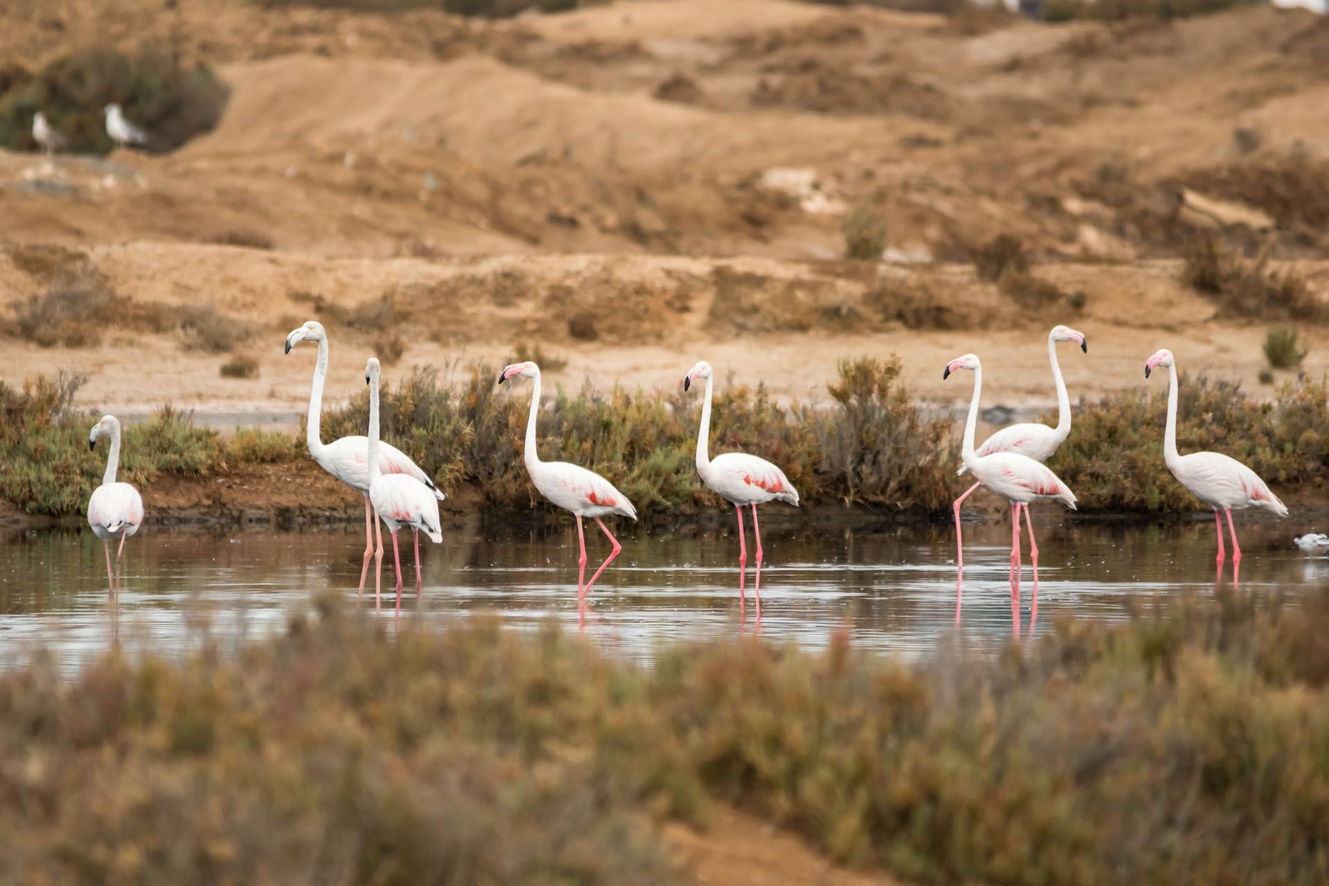
A group of flamingos in Ria Formosa © Taniaaraujo/Shutterstock

A group of flamingos in Ria Formosa © Taniaaraujo/Shutterstock

15. Ria Formosa Nature Park trails (e.g., Ludo Trail, Faro)

The Ludo Trail is an easy 4.3-mile (7 km) loop through the wetlands of Ria Formosa, just outside Faro. This flat trail gives you a glimpse into one of southern Europe’s most important coastal ecosystems. 

It’s especially well known for birdlife—over 200 species either live here or stop through during migration. You’ll probably see flamingos and spoonbills, and with a bit of luck, you might catch a glimpse of the colorful purple swamphen.

The route is mostly packed sand and raised wooden walkways, which makes it manageable for all kinds of walkers, including families with kids. Along the way, you’ll pass old salt pans still used for traditional salt harvesting. There’s plenty to see beyond birds, too—pine forests line parts of the trail, and you might notice butterflies or even Mediterranean chameleons along the edges.

How to get to Ria Formosa Trails

The trailhead is around 4.3 miles (7 km) from Faro’s center. You can cycle there easily—there’s a dedicated path and bikes for rent in town. 

Local buses to São Lourenço also stop nearby. If you’re driving, follow signs for Ludo or Quinta do Lago and use the reserve’s main parking area. Another option is a scenic water taxi from Faro marina that brings you close to the entrance.

When to visit Ria Formosa Trails

Winter (November to February) is the best time for birdwatching, when migratory species are at their peak. That said, there’s wildlife year-round. Early morning is usually the most active time. In spring, you’ll see wildflowers across the marshes. 

16. Trilho da Foz do Arelho

This 4.3-mile (7 km) loop hugs the cliffs above the Óbidos Lagoon where it meets the Atlantic. The views along this trail are wide open—one side looks out over the ocean, the other over the lagoon’s calmer waters. The trail has a few steep and sandy sections, so good shoes help, but it’s manageable for anyone with moderate hiking experience.

The trail takes you through coastal vegetation, dunes, and limestone outcrops. Birdwatchers will find plenty to look for, especially around the lagoon where herons and flamingos sometimes gather. 

Near the end, you’ll reach Salir do Porto, where Portugal’s tallest sand dune backs onto clear, shallow water. It’s a good place to cool off if the weather’s warm.

How to get to Foz do Arelho

From Lisbon, drive about 60 miles (97 km) north on the A8 toward Caldas da Rainha, then follow the signs to Foz do Arelho. Buses run from Caldas da Rainha to the village. The trail starts near the main beach parking area and is clearly marked with red and yellow hiking signs.

When to visit Foz do Arelho

Spring and early fall are usually the most comfortable times to hike, with cooler weather and fewer people around. In summer, you’ll get warmer water if you want to swim, but the midday heat and crowds can make the trail less pleasant. 

17. Mata de Albergaria (Via Geira), Gerês

This trail runs for about 5 miles (8 km) through one of Portugal’s most protected oak forests, following a stretch of the old Roman road known as Via Geira. You’ll walk beneath a dense canopy of moss-covered trees, past ancient stone milestones from the 1st century—several are still numbered in sequence.

The trail includes river crossings, sections of cobbled Roman road, and quiet forest paths. If you’re there in spring, look for the small purple Gerês lilies that bloom along the trail. 

The area is also home to Garrano wild ponies, and while Iberian wolves do live in the park, sightings are rare. The forest keeps things cool even in summer, and the filtered sunlight through the trees gives the whole area a quiet, almost hidden feeling.

How to get to Mata de Albergaria

Start from the village of Campo do Gerês. From Porto, it’s about a 60-mile (97 km) drive—take the A3 to Braga and then the N308 into the mountains. In summer, you can sometimes find buses from Braga to the village, but it’s best to check in advance. 

When to visit Mata de Albergaria

Late spring (May to June) is ideal for seeing wildflowers and enjoying mild temperatures. Summer is good too—the shade helps keep it cool even on hotter days. In fall, the forest turns golden and red. Winter is the trickiest season, with more rain, possible snow, and some sections harder to access.
 

18. São João da Pesqueira routes

These trails take you through the terraced hillsides of the Douro Valley, where vineyards, olive groves, and almond trees climb steep slopes down to the river. The walks around São João da Pesqueira range from about 3 to 6 miles (5 to 10 kilometers), and they’re generally easy to moderate depending on the route you pick.

Most of the trails follow old stone paths between vine rows, with views shifting as you gain or lose elevation. You’ll pass working wine estates and small villages where production has been going on for generations. Some locals still make Port using traditional methods, and if you plan ahead, you can taste it directly from them.

How to get to São João da Pesqueira

Driving from Porto takes around 2 hours. Take the A4 east, then follow the N222—this road runs alongside the Douro River and is especially scenic. It's maybe one of the best road trips in Portugal

If you’re not driving, you can take the train to Pinhão, then catch a local taxi to São João da Pesqueira. Once in town, the tourist office in the main square has maps and can suggest routes based on how much time or energy you have.

When to visit São João da Pesqueira

September and October line up with harvest season, so you might see grape-picking in action. Spring (March to May) brings almond blossoms and wildflowers, while summer shows the vineyards at their fullest. Just keep in mind that July and August can get hot—bring water and head out early. In winter, the leaves fall and reveal more of the stone terraces.

19. Sete Cidades Crater Rim Walk, Azores

This 7.5-mile (12-kilometer) loop circles the edge of the Sete Cidades caldera, one of the most iconic volcanic landscapes in the Azores. The twin lakes below—one green, one blue—sit inside the crater, and you’ll get plenty of chances to look down on them as you hike the ridge.

The trail includes both forested paths and open sections exposed to wind, and the elevation changes give you a range of perspectives. Plan for around 3 to 4 hours to walk the whole thing. It’s not a technical hike, but you’ll want a good weather window since views can disappear quickly if the fog rolls in.

How to get to Sete Cidades Crater Rim

From Ponta Delgada, it’s about a 30-minute drive west along the EN9-1A. The Vista do Rei viewpoint is a common starting point, and trail markers are easy to follow from there. Public buses run to the village of Sete Cidades, but service is limited. Renting a car is usually the easiest way to go, though some guided hikes include pickup if you're staying nearby (see our guide to Portugal accommodation).

When to visit Sete Cidades

The weather is most stable between April and October. May and June are especially green, with wildflowers all along the trail. If you want clear views of the lakes, go early in the day—by mid-morning, the fog often creeps in and lingers. Even in summer, the weather can shift quickly, so bring layers and check the forecast before heading out.

20. Levada das 25 Fontes (PR6), Madeira

This is one of Madeira’s classic levada walks, leading through dense laurel forest to a shaded waterfall where water flows down mossy rock walls. The hike follows an irrigation channel for most of the way, with a mix of flat stretches and a few narrow or uneven parts. It’s about 3.5 miles (5.5 kilometers) each way, or 7 miles (11 kilometers) round trip, and usually takes around 3 hours.

You’ll walk through a mix of tunnels, ferns, and trees that feel ancient. At the end, there’s a small amphitheater-like basin where several small falls come together. Even when the water’s not especially high, it’s a peaceful place to rest before heading back.

How to get to Levada das 25 Fontes

The trail begins at Rabaçal, near the Paul da Serra plateau. From Funchal, drive about 28 miles (45 kilometers) west via the ER110. Park at the upper lot, and you can either walk down the road or take a shuttle to the Rabaçal forestry house, where the trail starts. 

Buses from Funchal run to nearby Calheta, but they won’t get you all the way to the trailhead. Most people either drive or join a group tour.

When to visit Levada das 25 Fontes

Late winter through spring (February to June) is best if you want to see strong water flow at the falls. Start early—before 9am if you can—to avoid the biggest crowds. Weekdays are noticeably quieter. 

The trail can get slippery after rain, and some small stream crossings may be harder after heavy weather, so check the forecast before you go. September and October are also good months for hiking, with mild weather and fewer people on the trail.