Overview of the Laugavegur Trail
Most people take about 3 to 4 days to complete the trail, hiking around 8.5 miles (13.7km) a day. The standard route goes from north to south, starting in Landmannalaugar and ending in Þórsmörk—partly because the elevation gradually drops that way, and partly because that’s how the huts are booked.
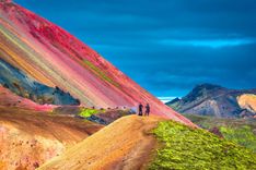
The trail starts with hot springs and colorful hills in Landmannalaugar, where you can take a dip before or after your trek. Around 75,000 to 100,000 people hike the trail every year, mostly in July and August.
The path itself isn’t too technical—it’s classed as moderate—but the weather is the tricky part. Conditions change fast, and you’ve got to be ready for rain, wind, fog, or even snow in the middle of summer. You can also tack on the Fimmvörðuháls trail at the end, which adds another 15.5 miles (25km) and takes you all the way to the town of Skógar.
Route summary
On the Laugavegur Trail, you'll pass some of the best places to visit in Iceland. You’ll start in the geothermal hills of Landmannalaugar, hike through the high-altitude obsidian fields around Hrafntinnusker, then descend into the lake-filled valley of Álftavatn.
After that, you cross black sand deserts near Emstrur before heading into the green birch forests of Þórsmörk. Each section feels completely different. In Hrafntinnusker, snow often lingers well into summer, and visibility can be limited by mist.
Álftavatn has open skies and still lakes, while Mælifellssandur feels like a black sand moonscape. Þórsmörk, by contrast, is full of plants and sits between three glaciers.
You’ll cross a few rivers along the way—some with footbridges (like Ljósá), others (like Þröngá) you’ll need to wade through. The whole trail is marked with blue stakes and yellow snow poles, though in bad weather, it’s easy to lose sight of them.
Landscape and difficulty
The trail itself is well maintained and straightforward, but there’s a steep climb on day one that catches people off guard. What really makes or breaks the hike is the weather. Early stages often get covered in thick fog, and snow patches can stick around even in July.
The Þórsmörk area gets a huge amount of rain—sometimes up to 30 feet a year—so staying dry can be a challenge. The terrain changes a lot too: you’ll walk on everything from lava rocks and loose gravel to packed snow and riverbeds.
The rivers vary—some are ankle-deep and easy, others are stronger and require caution. You don’t need to be an elite athlete to do this hike, but you should be comfortable walking for 5 to 7 hours a day while carrying a pack. Between the weather, the river crossings, and the remoteness, it’s more involved than a typical day hike, but definitely manageable with preparation (see our Iceland travel health tips for more on that).