Ayvalık and around
Thanks to its charming old quarter of picturesque Greek houses, Ayvalık, 56km south of Edremit, has long been popular with Turkish and European visitors. The closest good beaches are at the mainstream resort of Sarımsaklı, with some remoter, rockier ones on Cunda island, both easily reached from town. Ayvalık is also convenient for day-trips to ancient Pergamon, and the Greek island of Lésvos opposite, served by regular ferry.
Brief history
Due to its excellent anchorages, the area has been inhabited since ancient times, but today’s Ayvalık began as the Ottoman Greek settlement of Kydoníes during the early eighteenth century. Both Turkish and Greek names refer to the local quince orchards, now vanished.
In the 1790s, the town was effectively granted autonomy by Grand Vizier Cezayırlı Hasan Paşa, who, as an Ottoman admiral, had been rescued in 1771 by the Greeks of Ayvalık following a disastrous defeat by the Russian navy. This soon became the most prosperous and imposing town on the Aegean coast after İzmir, boasting an academy, a publishing house and around twenty Orthodox churches, many of which still remain, albeit converted into mosques after 1923. Ironically, most of the people resettled here were Greek-speaking Muslims from Crete and Mytilini (Lésvos), and many of Ayvalık’s older inhabitants still speak Greek.
Unlike resorts to the south that are dominated by the holiday trade, AYVALІK is relatively free of touts, and has retained a fishing fleet and olive-based commerce (including oil and green soap), as well as a prestigious classical music academy and some lively markets – Thursday is the special market day for produce from the surrounding villages, with its epicentre at two meydans either side of Annette’s House pansiyon.
Almost uniquely for the Aegean, central Ayvalık is pretty much a perfectly preserved Ottoman market town, though few of the traditional trades are left. Riotously painted horse-carts still clatter through the cobbled bazaar (home to a colourful, regional produce market every Sunday), emanating from a meydan to the south where the animals and their drivers wait for commissions.
While few specific sights other than converted nineteenth-century churches punctuate the warren of inland streets, use the minarets as landmarks and surrender to the pleasure of wandering under numerous wrought-iron window grilles and past ornately carved doorways.
A few soaring brick chimneys are all that survive of the factories that once churned out olive oil by the vat-load. Nowadays the work has moved into modern factories on the outskirts.
Cunda
Across the bay from Ayvalık, the island of CUNDA – known as Yonda in Ottoman times, and now officially Alibey Adası, and also accessible via causeway – constitutes either a good day-trip destination or an overnight halt. It’s a marginally quieter, less grand version of Ayvalık old town, with a lively main harbour and cobbled backstreets lined by restored stone houses – remnants of life before 1923, when Cunda was known as Moskhonísi to its Greek Orthodox inhabitants. After the Christians were sent to Greece, the island was resettled with Cretan Muslims from around Haniá, and most older people speak Cretan Greek as a matter of course. Cunda has become popular with affluent İstanbulites bent on owning an Aegean retreat, though the dense ranks of tatty trinket and ice-cream stalls along the quay clash somewhat with its twee image.
Halfway up the slope from the waterfront, the Orthodox Taksiyarhis Cathedral, heavily damaged by a 1944 earthquake, is undergoing a welcome restoration. At the top of the hill, a chapel and adjacent windmill have been converted by the Koç Foundation into a worthwhile café with stunning views.
Northern Cunda, known as Patriça, is supposedly a protected nature reserve – not that villa construction has completely stopped – and holds some relatively deserted beaches. A dirt road goes to them, while boat tours from Ayvalık harbour visit two derelict Greek monasteries, Áyios Yórgis and Áyios Dhimítrios tou Sélina, accessible only by sea.
Bergama
Although possible as a day trip from Ayvalık, Bergama, site of the ancient city of Pergamon, rates an overnight stop in its own right. Towering over modern Bergama, the stunning acropolis of the Pergamene dynasty is the main attraction.
Two lesser sights, the Asklepion and Kızıl Avlu, as well as the town’s medieval quarter, are also well worth exploring, making Bergama a strong historical stop on 9-day Turkey trips through the northern Aegean.
Bear in mind that the two parts of ancient Pergamon are some distance from each other and can be unshaded and extremely hot at midday in summer.
Brief history
Pergamon rose to prominence as the base of Lysimakhos, a successor to Alexander the Great who died in 281 BC. He left considerable treasure to his eunuch-steward Philetaeros who passed it on to his nephew Eumenes I, founder of the Pergamene dynasty. The city only achieved true greatness under Eumenes II (197–159 BC), who built its gymnasium, the Altar of Zeus, library, theatre and acropolis wall. Eumenes’ brother Attalos II ruled until 138 BC, followed by the five-year reign of the cruel but scholarly Attalos III, who perversely left the kingdom to the Romans. Under them Pergamon became an artistic and commercial centre of 150,000 people, but after the arrival of the Goths in 262 AD, it declined and fell into ruin.
The German engineer Carl Humann rediscovered ancient Pergamon in 1871, when some locals showed him a strange mosaic that turned out to be part of the relief from the Altar of Zeus. Humann bought the mosaic, and began excavating the acropolis. Work was completed by 1886, but unfortunately most of the finds were carted off to Germany, including the Altar of Zeus reliefs, now in the Pergamon Museum in Berlin.
In 1998 a second significant archeological site, the Roman spa and asklepion of Allianoi, was discovered 19km east of Pergamon. However, it had only been partly excavated before the Yortanlı irrigation dam flooded the site in 2011 despite domestic and international protest (see wallianoi.org). The site was first “re-buried” under a protective layer of clay so that future generations may be able to excavate it once the dam’s tenure (only 50 years say some experts) is complete.
Exploring Pergamon
Bergama’s various archeological sites are so widely spread out that only the most ardent (and thrifty) of walkers would insist on walking to them.
The entrance to the Acropolis is accessible on foot from the old town, but the most direct route is an uphill path that can be hard to find, while the main road, which is also steep, is not particularly direct, doubling back on itself for about 5km. Most visitors choose to ride up to the ticket booth by cable car and then walk down through the ruins.
The Asklepion is also an uphill hike from the town centre, either on a steep track or along a winding road. Both pass through a large, clearly marked military zone (no photos), closed to all traffic at dusk. More walker-friendly are the Archeological Museum and Kızıl Avlu, around 1500m apart and at the southern and northern ends of Bergama’s main road respectively.
Pergamon’s library and the birth of the modern book
Founded by Eumenes II and enlarged by Attalos II, both fanatical collectors of books, Pergamon’s Library grew to contain 200,000 titles – volumes by Aristotle and Theophrastos were paid for with their weight in gold. Eventually the Egyptian Ptolemies, alarmed at this growing rival to their own library in Alexandria, banned the export of papyrus, on which all scrolls were written, and of which they were sole producers.
In response to this bid to stem the library’s expansion, the Pergamene dynasty revived the old practice of writing on specially treated animal skins, parchment. That led quickly to the invention of the codex or paged book, since parchment couldn’t be rolled up like papyrus. The words “parchment” and the more archaic “pergamene” both derive from “Pergamon”. The library was appropriated by Mark Antony, who gave it to Cleopatra as a gift, and many of its works survived in Alexandria until destroyed by the Arabs in the seventh century.
The acropolis
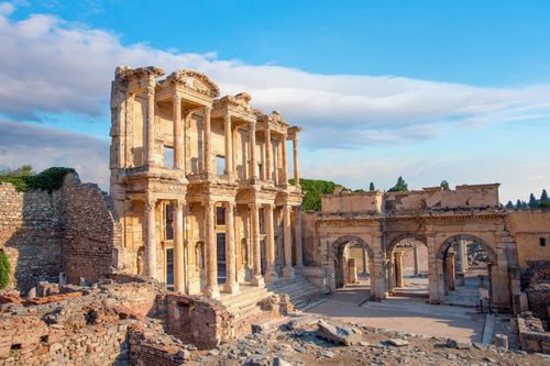
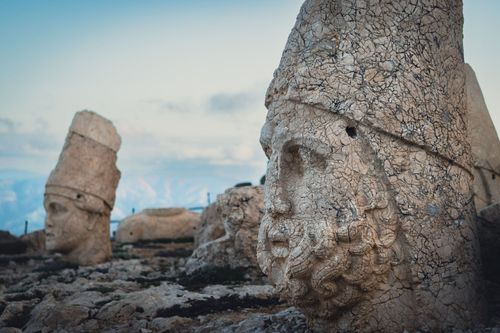
Once you enter the site of Pergamon’s Acropolis, an uphill path from the former city gate leads southwest to the huge, square Altar of Zeus, standing in the shade of two large stone pines. Built by Eumenes II to commemorate his father’s victory over the Gauls, the altar was decorated with reliefs depicting the battle between the Titans and the gods, symbolizing the triumph of order over chaos (and, presumably, that of Attalos I over the Gauls). Even today its former splendour is apparent, if much diminished by the removal of the reliefs to Berlin. The main approach stairway was on the west, now the most deteriorated side.
Directly northeast of, and exactly parallel to, the Altar of Zeus, on the next terrace up, lie the sparse remains of the third-century BC Temple of Athena. Only some of its stepped foundations survive in situ, although the entrance gate, with its inscribed dedication “King Eumenes to Athena the Bearer of Victories”, has been reconstructed in Berlin. The scanty north stoa of the temple once housed Pergamon’s famous Library, which at its peak rivalled Alexandria’s.
A narrow staircase leads down from the Temple of Athena to the spectacular Hellenistic theatre, cut into the hillside and with capacity for ten thousand spectators. The wooden stage was removed after each performance – the holes into which the supporting posts were driven can still be seen on the stage terrace – to allow free access to the Temple of Dionysos, on the same terrace.
Still further north and uphill looms the Corinthian Temple of Trajan, where both Trajan and Hadrian were revered during Roman times – their busts were also taken to Berlin. German archeologists have re-erected some of the temple columns, plus much of the stoa that surrounded the shrine on three sides. The north architrave is lined with Medusa heads, two of them modern recastings.
Behind the temple are the remains of barracks and the highest reaches of the city’s perimeter wall. Nearby yawns a cistern once fed by an aqueduct, traces of which are still visible running parallel to a modern one on the hillside to the northwest. Finally, as you begin your descent back down towards the main entrance, you’ll pass – east of the library and Athena temple – the extensive but jumbled ruins of the royal palaces.
The terrace south of the Altar of Zeus now holds little more than Carl Humann’s grave, though as the upper agora it was once the commercial and social focus of Pergamon. An ancient street descends past the Temple of Demeter, where the local variant of the Eleusinian Mysteries was enacted. Across the way lies the gymnasium, where the city’s youth were educated. Its upper level, with its palaestra and lecture hall, was for young men, the middle was used by the adolescents, and the lower served as a playground for small boys. From the lower agora, the path back down to town is indicated by blue waymarks.
Çanakkale
Blessed with a superb setting on the Dardanelles straits, ÇANAKKALE is a vibrant harbour town with a multicultural past that can be found in its compact old quarter, and a busy seafront that’s home to a replica of the Trojan horse used in the 2004 film Troy. While the town undeniably makes a convenient base for the World War I battlefields at Gallipoli, on the European side of the Dardanelles, as well as the ruins of Troy, Çanakkale itself deserves at least an overnight stop, with a couple of interesting sights and a nightlife scene that positively hums in the summer. It’s also the starting point for sea buses to the Turkish Aegean islands of Gökçeada and Bozcaada.
Çanakkale Pottery
The name Çanakkale means “Pottery Castle”, after the unique local ceramics that find their way into the ethnographic section of every Turkish museum. Dating from the nineteenth century, the style favours brown, green and yellow glazes – a statue-sized model of a popular design looks over Cumhuriyet Bulvarı – and was once considered crude and garish. Tastes seem to have changed, however. Genuine antique Çanakkale pottery is back in fashion, and fetches high prices in the fashionable decor shops of İstanbul.
A good place to poke around for a hidden bargain is the well-restored old bazaar beyond the clocktower. With its ornate shops – especially the 1889-built Yalı Hanı – and houses, it testifies to the town’s pre-1923 polyglot profile. Until Cretan Muslims arrived as part of the population exchanges, Çanakkale (like İzmir) held significant Greek, Jewish and Armenian populations, and even foreign consuls – the Italian one donated the clocktower in 1897.
The weary waters of the Dardanelles
The Dardanelles – in Turkish, Çanakkale Boğazı – have defined Çanakkale’s history and its place in myth. The area’s Classical name, Hellespont, derives from Helle, who, escaping from her wicked stepmother on the back of a winged ram, fell into the swift-moving channel and drowned. From Abydos on the Asian side, the youth Leander used to swim to Sestos on the European shore for trysts with his lover Hero, until one night he too perished in the currents; in despair, Hero drowned herself as well. In 1810, enthusiastic swimmer Lord Byron succeeded in crossing the channel only on his second attempt – a feat he often claimed as his greatest-ever achievement.
Persian hordes under Xerxes crossed these waters on their way to Greece in 480 BC, and in 411 and 405 BC the last two naval battles of the Peloponnesian War took place in the straits; the latter engagement ended in decisive defeat for the Athenian fleet. Twenty centuries later, Mehmet the Conqueror constructed the elaborate fortresses of Kilitbahir and Çimenlik Kale, across from each other, to tighten the stranglehold being applied to doomed Constantinople.
In March 1915, an Allied fleet attempting to force the Dardanelles and attack İstanbul was repulsed by Turkish shore batteries, with severe losses, prompting the even bloodier land campaign usually known as Gallipoli. These days the straits are still militarized, and modern Çanakkale is very much a navy town.
Foça
The small coastal resort of FOÇA, 86km north of İzmir, is an attractive and welcoming place, where the charming cobbled backstreets are lined with Greek fishermen’s cottages and a few more opulent Ottoman mansions. A very worthwhile and relaxing stopover, it’s sometimes called Eski (Old) Foça to distinguish it from its smaller and less interesting neighbour 25km further north, Yeni Foça, which is unlikely to appeal to international visitors.
Derived from the ancient Greek for “seal”, the name “Phokaia” refers either to the suggestively shaped islets offshore, or to the handful of Mediterranean monk seals that still live in the local waters. They’re monitored and protected by the Turkish Underwater Research Foundation, but you’re most unlikely to see any on a boat tour. Frankly you’d need to be a seal to really enjoy the sea here which, thanks to strong currents and a sharp drop-off, is notoriously chilly for much of the year.
Thanks to a pervasive military presence, much of the nearby coast is in any case out of bounds to visitors. Foça’s naval base houses the Turkish Amphibious Brigade, and is the only location in the country where marines are trained.
Ancient Phokaia
Foça stands on the site of Phokaia, founded around 1000 BC by Ionian colonists. Great seafarers, the Phokaians plied the Mediterranean as far as the Straits of Gibraltar, founding numerous colonies, including (around 600 BC) Massalia, now Marseilles.
Little now remains of the ancient town. The most striking remnant, 8km east of modern Foça, is the Taş Ev, an unusual tomb cut from the rock in the eighth century BC, squatting beside an Ottoman bridge and a modern cemetery. A small, much later ancient theatre marks the east entry to Foça, while some mosaic pavements from a Roman villa, including a portrayal of four Bacchus heads and birds, have been unearthed about 150m southwest.
Beskapılar fortress
The oldest intact structure in Foça itself is the waterfront Beşkapılar fortress (open for art exhibitions). Originally Byzantine, it was much modified by successive occupiers, including the Genoese, who occupied the castle until the Ottomans seized it in the fifteenth century. Two interesting mosques from that era bracket Beşkapılar: the unheralded but beautiful Fatih Camii, and the Kayalar Camii, at the summit of the castle enclosure, sporting a distinctly lighthouse-like minaret.
The harbours
Foça’s castle headland splits the bay into two smaller harbours. The northerly, more picturesque Küçükdeniz is where most of the action takes place, along seafront Reha Midilli Caddesi, while bleak, southerly Büyükdeniz is of interest only as the point where ferries from Lésvos dock and the fishing fleet is anchored. Neither bay has a decent beach, though that doesn’t stop bathers from establishing themselves on the slightly grubby shingle or launching themselves from platforms at rocky Küçükdeniz.
Beaches
Some excellent beaches are dotted along the scenic 20km of road that separates Foça from Yeni Foça. However, they’re either only accessible on foot, or by paying fees of up to TL15 to the campsites that own them, such as People, 5km out, and Kosova, 2km beyond. The best sand is at Acar Kamping (after 10km), but 700m before that, paths from the roadside lead down beneath some high-voltage power lines to a succession of idyllic coves opposite an islet. Alternatively, Mambo Beach Club, 5km short of Yeni Foça, usually allows free access to the beach if you patronize their snack bar.