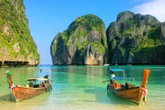
Southern Thailand: the Andaman coast Travel Guide

As Highway 4 switches from the east flank of the Thailand peninsula to the Andaman coast it enters a markedly different country: nourished by rain nearly all the year round, the vegetation down here is lushly tropical, with forests reaching up to 80m in height, and massive rubber, palm-oil and coconut plantations replacing the rice and sugar-cane fields of central Thailand. Sheer limestone crags spike every horizon and the translucent Andaman Sea laps the most dazzlingly beautiful islands in the country, not to mention its finest coral reefs. This is of course the same sea whose terrifyingly powerful tsunami waves battered the coastline in December 2004, killing thousands and changing countless lives and communities forever. The legacies of that horrific day are widespread (see Tsunami Museum), but all the affected holiday resorts have been rebuilt, with the tourist dollar now arguably more crucial to the region’s well-being than ever before.

The cultural mix along the Andaman coast is also different from central Thailand. Many southern Thais are Muslim, with a heritage that connects them to Malaysia and beyond. This is also the traditional province of nomadic chao ley, or sea gypsies, many of whom have now settled but still work as boat captains and fishermen. The commercial fishing industry, on the other hand, is mostly staffed by immigrants – legal and not – from neighbouring Burma, just a few kilometres away along the northern Andaman coast.

The attractions of the northern Andaman coast are often ignored in the race down to the high-profile honeypots around Phuket and Krabi, but there are many quiet gems up here, beginning with the low-key little sister islands of Ko Chang (quite different from its larger, more famous East Coast namesake) and Ko Phayam, where the hammocks and paraffin lamps offer an old-style travellers’ vibe that’s harder to find further south. Snorkellers and divers are drawn in their hundreds to the reefs of the remote National Park island chains of Ko Surin and Ko Similan, with many choosing to base themselves at the mainland beach resort of Khao Lak, though homestay programmes around Khuraburi offer an interesting alternative. Inland, it’s all about the jungle – with twenty-first-century amenities – at the enjoyable Khao Sok National Park, where accommodation is on rafts on the lake and treehouses beneath the limestone crags.

Phuket, Thailand’s largest island, is the region’s major resort destination for families, package tourists and novice divers; its dining, shopping and entertainment facilities are second to none, but the high-rises and hectic consumerism dilute the Thai-ness of the experience. There’s Thai life in spades across on the quiet rural island of Ko Yao Noi, scenically located within the spectacular bay of Ao Phang Nga, whose scattered karst islets are one of the country’s top natural wonders, best appreciated from a sea-canoe. The Andaman coast’s second hub is Krabi province, rightly famous for its turquoise seas and dramatic islands. Flashiest of these is the flawed but still handsome Ko Phi Phi, with its great diving, gorgeous beaches and high-octane nightlife. Mainland and mainstream Ao Nang can’t really compete, but is at least close to the majestic cliffs and superb rock-climbing of the Railay peninsula at Laem Phra Nang. Offshore again, there’s horizon-gazing aplenty at mellow, barely developed Ko Jum and the choice of half a dozen luxuriously long beaches, and plentiful resort facilities, at Ko Lanta Yai.

Unlike the Gulf coast, the Andaman coast is hit by the southwest monsoon, which usually generally lasts from the end of May until at least the middle of October. During this period, heavy rain and high seas render some of the outer islands inaccessible, but conditions aren’t usually severe enough to ruin a holiday on the other islands, or on the mainland, and you’ll get tempting discounts on accommodation. Some bungalows at the smaller resorts shut down entirely during low season (highlighted in the text), but most beaches keep at least one place open, and some dive shops lead expeditions year-round.

The Kra Isthmus

Thailand’s Andaman coast begins at Kraburi, where, at kilometre-stone 545 (the distance from Bangkok), a signpost welcomes you to the Kra Isthmus, the narrowest part of peninsular Thailand. Just 44km separates the Gulf of Thailand from the Andaman Sea’s Chan River estuary, and Burmese border, here. Though a seemingly obvious short cut for shipping traffic between the Indian Ocean and the South China Sea, avoiding the 1500km detour via the Strait of Malacca, the much-discussed Kra Canal project has yet to be realized, despite being on the table for over three hundred years.

Activities around Krabi, Ao Nang and Laem Phra Nang

Any tour agent in Krabi town, Ao Nang, Klong Muang or Railay can set you up on these snorkelling day-trips and other activities; prices usually include transport from your accommodation. Diving and rock-climbing are also available.

Snorkelling day-trips

By far the most popular organized outings from Krabi, Ao Nang and Laem Phra Nang are the snorkelling trips to nearby islands. The main islands in question are Ko Poda, Ko Tub and Chicken Island, all of them less than half an hour’s longtail ride from Ao Nang or Railay. There are various permutations, offered by numerous companies, including the number of islands you visit (usually three, four or five) and whether you go in a longtail boat, a larger wooden boat or speedboat; prices start as low as B450 for a longtail trip to three islands, including packed lunch and snorkel set. In all cases you should be prepared to share the experience with dozens, even hundreds, of others, because pretty much everyone congregates at the same spots. It’s a lot more fun than it sounds though – so long as you’re not expecting a solitary experience.

It’s also possible to organize your own boat trip with the longtail boatmen on Ao Nang waterfront. Their prices are fixed, but don’t include snorkelling equipment or lunch: for the return trip to either Ko Poda, Ko Tub or Chicken Island (8am–4pm), they charge B300 per person, minimum six people; for Ko Hong it’s B2500 per boat per full day, for Bamboo Island, near Ko Phi Phi, B3800 per boat per full day. Krabi town is quite a bit further away so its boatmen charge B1800–2300 for the three main islands.

From some angles, one of the pinnacles on Chicken Island does indeed look like the scrawny neck and beaky head of a chicken. There’s decent snorkelling off its coast, with a fair range of reef fish and quite a lot of giant clams, though most of the reef is either bleached or dead. Its dazzlingly white-sand northeastern shore, which has a food stall, toilets and kayak rental, is connected to the islets of Ko Tup by a sandbank, which is walkable at low tide – quite a striking sight as you arrive to see other visitors seemingly walking on water. Nearby Ko Poda, which sits directly in front of the Ao Nang beachfront, is encircled by lovely white-sand beaches and clear turquoise water. There’s a restaurant here and plenty of shade under the casuarina trees, so this is the typical lunch stop; sandwich-selling boats dock here too. Though you might get three hundred people lunching on the shore here at any one time, it’s big enough to cope. Some itineraries also feature Ao Phra Nang and its cave, on the Laem Phra Nang (Railay) peninsula, and this is the one to avoid unless you enjoy scrambling for your metre of sand on this overrun little bay.

Cycle rides

Half- and full-day rides into the Krabi countryside, or to Ko Klang, Khao Phanom Bencha falls or Khlong Tom’s Emerald Pool, with Krabi Eco Cycle, based about 2km inland from the Hat Nopparat Thara National Park visitors’ centre on Route 4202.

Elephant trekking

Nosey Parker‘s Elephant Trekking, 7km north of Ao Nang, has a good reputation. From B800 for an hour’s trek along the river and elephant bathing.

Sea canoeing

Guided and self-paddle trips around the spectacular karst islands and secret lagoons of Ao Phang Nga, usually focusing on Ao Luk, Ao Thalen and Ko Hong in the eastern bay. Dozens of companies offer this, including Sea Kayak Krabi, Soi 2, Thanon Maharat, Krabi town, who offer a multitude of day and multi-day trips, charging B1500 for a full-day trip to Ao Thalen, for example.

Thai cookery lessons

Ya’s Thai Cookery School, about 4km inland of Ao Nang off Route 4203, runs morning and afternoon courses.

Ranong

Despite being the soggiest town in the country, with over 5000mm of rain a year, RANONG has a pleasing buzz about it, fuelled by the mix of Burmese, Thai, Chinese and Malay inhabitants. It’s a prosperous town, the lucrative nineteenth-century tin-mining concessions now replaced by a thriving fishing industry centred around the port of Saphan Pla, 5km southwest of town, and its scores of fishing boats and fish-processing factories staffed mainly by notoriously poorly treated Burmese workers. As with most border areas, there’s also said to be a flourishing illegal trade in amphetamines, guns and labour, not to mention the inevitable tensions over international fishing rights, which sometimes end in shoot-outs, though the closest encounter you’re likely to have will be in the pages of the Bangkok Post. Thai tourists have been coming here for years, to savour the health-giving properties of the local spring water, but foreign travellers have only quite recently discovered it as a useful departure point for the alluring nearby little islands of Ko Chang and Ko Phayam. The other reason to stop off in Ranong is to make a visa run to the Burmese town of Kaw Thaung.

A stroll along the town centre’s main road, Thanon Ruangrat, brings its history and geography to mind. The handsome, if faded, shopfront architecture bears many of the hallmarks of nineteenth-century Sino-Portuguese design, with its arched “five-foot” walkways shading pedestrians, pastel paintwork and shuttered windows. Chinese goods fill many of the shops – this is a good place to stock up on cheap clothes too – and many signs are written in the town’s three main languages: Thai, Chinese and curly Burmese script.

Into Burma: visa runs and Kaw Thaung (Ko Song)

The southernmost tip of Burma – known as Kaw Thaung in Burmese, Ko Song in Thai, and Victoria Point when it was a British colony – lies just a few kilometres west of Ranong across the gaping Chan River estuary, and is easily reached by longtail boat from Saphan Pla fishing port just outside Ranong town centre. It’s quite straightforward for foreign tourists to hop across to Burma at this point, and hop back for a new fifteen-day stay in Thailand (the “tourist visa exemption”). You can either do it independently, as described below, or you can make use of one of the all-inclusive “visa run” services advertised all over town, including at Pon’s Place (B850 including visa). Most visa-run operators use the Saphan Pla route, but they can also book you on the faster, more luxurious Andaman Club boat (B1000 including visa), which departs from the Andaman Club pier 5km north of Ranong’s town centre and travels to and from the swanky Andaman Club hotel, casino and duty-free complex, located on a tiny island in Burmese waters just south of Kaw Thaung.

Boats to Kaw Thaung leave from the so-called Burmese Pier in the port of Saphan Pla, 5km southwest of town and served by songthaews from Ranong market. Thai exit formalities are done at the pier, after which longtail boats take you to Kaw Thaung and Burmese immigration. Here you pay US$10 (or B500) for a pass that should entitle you to stay in Kaw Thaung for a week but forbids travel further than 8km inland. Note that Burma time is thirty minutes behind Thailand time, and that to get back into Thailand you’ll have to be at the immigration office in Saphan Pla before it closes at 6pm. Thai money is perfectly acceptable in Kaw Thaung.

There’s nothing much to do in Kaw Thaung itself, but it has quite a different vibe to Thai towns. As you arrive at the quay, the market, immigration office and tiny town centre lie before you, while over to your right, about twenty minutes’ walk away, you can’t miss the hilltop Pyi Taw Aye Pagoda, surmounted by a huge reclining Buddha and a ring of smaller ones. Once you’ve explored the covered market behind the quay and picked your way through the piles of tin trunks and sacks of rice that crowd the surrounding streets, all that remains is to take a coffee break in one of the quayside pastry shops.

Ko Phayam

The diminutive kangaroo-shaped island of KO PHAYAM offers fine white-sand beaches and coral reefs and is home to around five hundred people, most of whom either make their living from prawn, squid and crab fishing, or from growing cashew nuts, sator beans, coconut palms and rubber trees. Many islanders live in Ko Phayam’s only village, behind the pier on the northeast coast, which connects to other corners of the island by a network of concrete roads and rutted tracks. The bays either side of the village have a couple of nice places to stay, but the main beaches and accommodation centres are on the west coast, at Ao Yai and Ao Kao Kwai. A motorbike taxi service covers all routes, but no journey is very great as the island measures just five by eight kilometres at its widest points.

Ko Phayam has a livelier, younger and slightly more developed feel than neighbouring Ko Chang, underlined by a low-key beach-bar scene – all hand-painted signs and driftwood sculptures – and the presence of a significant number of foreigners who choose to spend six or more months here every year. Some expats even take up the rainy-season challenge, staying on through the downpours and rough seas that lash the island from June to October, but a number of bungalows close down during this time and staff take refuge in Ranong. As the island gets more popular, residents and expats are beginning to try and forestall the inevitable negative impact on the island’s environment. In particular, they are urging visitors not to accept plastic bags from the few shops on the island, to take non-degradable rubbish such as batteries and plastic items back to the mainland, and to minimize plastic water-bottle usage by buying the biggest possible bottles and by asking to refill them from the water coolers that all bungalow resorts have.

Activities on Ko Phayam

Most bungalows can arrange fishing and snorkelling day-trips, while Oscar’s in the village takes people wakeboarding in the bay. The dive companies teach PADI courses and run liveaboards to Ko Surin, Richelieu Rock, Ko Tachai, Ko Bon and Ko Similan (from about B16,000 for three days, not including equipment).

Khuraburi

The small town of KHURABURI, 110km south of Ranong on Highway 4, is the main departure point for the magnificent national park island chain of Ko Surin. Much closer to Khuraburi are the islands of Ko Ra and Ko Phra Thong, which offer empty beaches and decent snorkelling and bird-watching, or there’s the chance to participate in typical village life at homestays in mainland coastal communities.

Khuraburi’s commercial heart is a 500m strip of shops and businesses either side of Highway 4. Most travellers use the town just as a staging post en route to or from the Surin islands: the main pier for boats to the islands is just 7.5km away, and Khuraburi’s tour agents sell boat tickets and offer transport to the pier. Though lacking in famous attractions, the local area is nonetheless scenic, both offshore and inland: with an afternoon or more to spare, you could either rent a motorbike, mountain bike or kayak to explore it independently, or charter a motorbike taxi or longtail boat.

Ko Ra

Hilly, forested Ko Ra (measuring about 10km north to south and 3km across) sits just off Khuraburi pier’s mangrove-lined estuary and is graced with intact rainforest full of towering trees, hornbills and wild, empty beaches. The island is home to some two dozen chao ley people, plus just one place to stay, the rather special American–Thai Ko Ra Ecolodge. On offer are half-day guided tours to the nearby Moken village on Ko Ra; kayak rental and guided day and multi-day sea-kayaking trips; guided and self-guided hiking and bird-watching; yoga classes and retreats; snorkelling trips to nearby Ko Surin (B2900 per person, all-inclusive), as well as to the little-visited islands of Laem Son National Park; and diving to the Surin islands (B6900 for two dives, not including national park entrance fee and equipment rental) and Reef Check courses to monitor the local coral.

Andaman Discoveries homestay programme

Khuraburi is the headquarters of the community-based tourism initiative Andaman Discoveries, which runs a recommended day-trip and homestay programme in several local villages, as well as interesting trips to Ko Surin. It was established after the tsunami to help the area’s many devastated fishing communities get back on their feet and has since developed a range of stimulating one- to five-day packages featuring all sort of village jobs and activities, from soap-making and batik design to cashew nut-farming and roof-thatching. The office is just east off the highway (south of the bus station), up the soi beside the police box, across from the post office.

Ko Surin

Unusually shallow reefs, a palette of awesomely clear turquoise waters and dazzling white sands, and dense forests of lofty dipterocarps combine to make the islands of Ko Surin one of the most popular destinations in south Thailand. However, Ko Surin’s most famous feature, its spectacular and diverse coral lying in fields just below the surface at the perfect depth for snorkelling, was severely bleached by a sudden rise in sea temperature in early 2010. Four of the most popular reefs are now closed to visitors, though half a dozen other sites that were less severely affected by the bleaching remain open; the national park is still a good spot for snorkellers, with plenty of fish to see, but it will take many years for the reefs to recover.

Ko Surin is very much an outdoors experience, with the bulk of accommodation in national park tents, no commerce on the islands at all, and twice-daily snorkelling the main activity. Several tour operators run snorkelling day-trips from Khuraburi, and there are diving trips too, most of which also take in nearby Richelieu Rock, considered to be Thailand’s top dive site, but independent travel is also recommended. Because the islands are so far out at sea, Ko Surin is closed to visitors from roughly May to October, when monsoon weather renders the 60km trip a potentially suicidal undertaking.

Ko Similan

Rated as one of the world’s best spots for both above-water and underwater beauty, the eleven islands at the heart of the Mu Ko Similan National Park are among the most exciting diving destinations in Thailand. Massive granite boulders set magnificently against turquoise waters give the islands their distinctive character, but it’s the 30m visibility that draws the divers. The 5000-year-old reefs are said to be the oldest in Thailand, so there’s an enormous diversity of species, and the underwater scenery is nothing short of overwhelming: the reefs teem with coral fish, and you’ll also see turtles, manta rays, moray eels, jacks, reef sharks, sea snakes, red grouper and quite possibly white-tip sharks, barracuda, giant lobster and enormous tuna.

The islands lie 64km off the mainland and include the eponymous Ko Similan chain of nine islands as well as two more northerly islands, Ko Bon and Ko Tachai, which are both favoured haunts of manta rays and whale sharks and are halfway between the Similan chain and the islands of Ko Surin. The Similans are numbered north–south from nine to one and are often referred to by number: Ko Ba Ngu (9), Ko Similan (8), Ko Payoo (7), Ko Hin Posar (aka Ko Hok; 6), Ko Ha (5), Ko Miang (4), Ko Pahyan (3), Ko Pahyang (2) and Ko Hu Yong (1). The national park headquarters and accommodation is on Ko Miang and there’s also a campsite and restaurant on Ko Similan. Ko Similan is the largest island in the chain, blessed with a beautiful, fine white-sand bay and impressive boulders and traversed by two nature trails; Ko Miang has two pretty beaches, twenty minutes’ walk apart, and three nature trails; Ko Hu Yong has an exceptionally long white-sand bay but access is restricted by the Thai navy as turtles lay their eggs there from November to February.

Such beauty has not gone unnoticed and the islands are extremely popular with day-trippers from Phuket and Khao Lak, as well as with divers and snorkellers on longer live-aboard trips. This has caused the inevitable congestion and environmental problems and the Similan reefs have been damaged in places by anchors and by the local practice of using dynamite in fishing. National parks authorities have responded by banning fishermen and enforcing strict regulations for tourist boats, including closing the islands during the monsoon season, from May to October.

Ko Yao Noi

Located in an idyllic spot in Phang Nga bay, almost equidistant from Phuket, Phang Nga and Krabi, the island of KO YAO NOI enjoys magnificent maritime views from almost every angle and makes a refreshingly tranquil getaway. Measuring about 12km at its longest point, it’s home to some four thousand islanders, the vast majority of them Muslim, who earn their living from rubber and coconut plantations, fishing and shrimp-farming. Tourism here is low-key, not least because the beaches lack the wow factor of more sparkling nearby sands, and visitors are drawn instead by the rural ambience and lack of commercial pressures. Nonetheless, there’s decent swimming off the east coast at high tide, and at low tide too in a few places, and plenty of potential for kayaking, rock-climbing and other activities.

Most tourists stay on the east side, which has the bulk of the accommodation, at Hat Tha Khao, Hat Khlong Jaak (Long Beach), Hat Pasai and Laem Sai. Exploring the interior is a particular pleasure, either via the barely trafficked round-island road as it runs through tiny villages and the island’s diminutive town, Ban Tha Khai, or via the trails that crisscross the forested interior, where you’ve a good chance of encountering monkeys as well as cobras and even pythons, not to mention plenty of birds, including majestic oriental pied hornbills.

Ko Yao Noi activities

Kayaking and snorkelling

Kayaking around the coast is a very enjoyable pastime, and the dozens of tiny islands visible from eastern shorelines make enticing destinations for experienced paddlers; kayaks can be rented through Ko Yao Noi hotels for about B300 per day. Just about every hotel and travel agent sells kayaking and snorkelling trips to Ko Hong and other islands in Ao Phang Nga.

Diving

Diving trips and courses on the island are the speciality of Koh Yao Diver, where two local dives cost B3600, two dives at the reefs around Phi Phi in a longtail B5520, and the Openwater course is B16,680.

Rock-climbing

Ko Yao Noi is fast becoming a respected destination for rock-climbers, who appreciate the fresh sites and uncrowded routes compared to the hectic scene at nearby Ton Sai and Railay. There are over 150 bolted routes on the island, from beginner level to advanced (5 to 8A), established by the American and Thai climbers who run The Mountain Shop in Ban Tha Kao. Many routes are over water and accessible only by boat, or at the least via a hike off the dirt track to Paradise hotel.

Ao Phang Nga

Protected from the ravages of the Andaman Sea by Phuket, AO PHANG NGA has a seascape both bizarre and beautiful. Covering some four hundred square kilometres of coast between Phuket and Krabi, the mangrove-edged bay is spiked with limestone karst formations up to 300m in height, jungle-clad and craggily profiled. This is Thailand’s own version of Vietnam’s world-famous Ha Long Bay, reminiscent too of Guilin’s scenery in China, and much of it is now preserved as national park. The bay is thought to have been formed about twelve thousand years ago when a dramatic rise in sea level flooded the summits of mountain ranges, which over millions of years had been eroded by an acidic mixture of atmospheric carbon dioxide and rainwater. Some of these karst islands have been further eroded in such a way that they are now hollow, hiding secret lagoons or hongs that can only be accessed at certain tides and only by kayak. The main hong islands are in the western and eastern bay areas – to the west or east of Ko Yao Noi, which sits roughly midway between Phuket and Krabi. But the most famous scenery is in the central bay area, which boasts the biggest concentration of karst islands, and the weirdest rock formations.

The hongs

Hongs are the pièce de résistance of Ao Phang Nga: invisible to any passing vessel, these secret tidal lagoons are enclosed within the core of seemingly impenetrable limestone outcrops, accessible via murky tunnels that can only be navigated at certain tides in kayaks small enough to slip beneath and between low-lying rocky overhangs. Like the karsts themselves, the hongs have taken millions of years to form, with the softer limestone hollowed out from above by the wind and the rain, and from the side by the pounding waves. Eventually, when the two hollows met, the heart of the karst was able to fill with water via the wave-eroded passageway at sea level, creating a lagoon. The world inside these roofless hollows is an extraordinary one, protected from the open bay by a ring of cliff faces hung with vertiginous prehistoric-looking gardens of upside-down cycads, twisted bonsai palms and tangled ferns. And as the tide withdraws, the hong’s resident creatures emerge to forage on the muddy floor, among them fiddler crabs, mudskippers, dusky langurs and crab-eating macaques, with white-bellied sea eagles often hovering overhead.

Phang Nga town

Friendly if unexciting little PHANG NGA TOWN, beautifully located under looming limestone cliffs edged with palm groves midway between Phuket and Krabi, serves mainly as a point from which to organize budget longtail trips around the spectacular karst islands of Ao Phang Nga. But there are also several caves and waterfalls nearby, accessible on cheap tours run by Phang Nga tour operators.

Tours from Phang Nga town

Ao Phang Nga

The most popular budget tours of Ao Phang Nga are the longtail-boat trips run by tour operators based inside Phang Nga bus station. Competition between these outfits is fierce and the itineraries they offer are almost identical, so it’s best to get recommendations from other tourists fresh from a bay trip, especially as reputations fluctuate with every change of staff. To date the one that’s remained most constant is Mr Kean Tour; next door but one is Sayan Tour. Both offer half-day tours of the bay costing B500 per person (including national park fee; minimum four people), as well as full-day trips, which cost B800, including lunch and national park fee; take the 8.30am tour to avoid seeing the bay at its most crowded. All tours include a chance to swim in the bay, and most offer the option of an hour’s canoeing around Ko Thalu as well, for an extra B350.

All tour operators also offer the chance to stay overnight at their own guesthouse on Ko Panyi. Mr Kean can also sometimes offer (dependent on the tides) an interesting alternative overnight programme on his home island of Ban Mai Phai, a much less commercial version of Ko Panyi, with the chance to trek, cycle and kayak.

Local sights around Phang Nga town

Mr Kean can arrange trips to Tham Phung Chang, or Elephant Belly Cave, a natural 1200m-long tunnel through the massive 800m-high wooded cliff that towers over the Provincial Hall, about 4km west of the town centre. With a bit of imagination, the cliff’s outline resembles a kneeling elephant, and the hollow interior is, of course, its belly. You can travel through the elephant’s belly to the other side of the cliff and back on a two-hour excursion that involves wading, rafting and canoeing along the freshwater stream, Khlong Tham, that has eroded the channel.

Mr Kean also offers tours that take in several other local caves, plus Sa Nang Manora Forest Park, which has hiking trails through thick, impressive rainforest and several waterfalls with swimmable pools, 9km north of the town centre.

Laem Phra Nang: Railay and Ton Sai

Seen from the close quarters of a longtail boat, the combination of sheer limestone cliffs, pure white sand and emerald waters around the LAEM PHRA NANG peninsula is spectacular – and would be even more so without the hundreds of other admirers gathered on its four beaches. The peninsula (often known simply as Railay) is effectively a tiny island, embraced by impenetrable limestone massifs that make road access impossible – but do offer excellent, world-famous rock-climbing; transport is by boat only, from Krabi town or, most commonly, from nearby Ao Nang. It has four beaches within ten minutes’ walk of each other: Ao Phra Nang graces the southwestern edge, and is flanked by East and West Railay, just 500m apart; Ao Ton Sai is beyond West Railay, on the other side of a rocky promontory. Almost every patch of buildable land fronting East and West Railay has been taken over by bungalow resorts, and development is creeping up the cliffsides and into the forest behind. But at least high-rises don’t feature, and much of the construction is hidden among trees or set amid prettily landscaped gardens. Accommodation is at a premium and not cheap, so the scene on West and East Railay, and Ao Phra Nang, is predominantly holidaymakers on short breaks rather than backpackers. The opposite is true on adjacent Ao Ton Sai, Krabi’s main travellers’ hub and the heart of the rock-climbing scene.

West Railay

The loveliest and most popular beach on the cape is WEST RAILAY, with its gorgeous white sand, crystal-clear water and impressive karst scenery at every turn. The best of the peninsula’s bungalow hotels front this shoreline, and longtail boats from Ao Nang pull in here too, so it gets crowded.

East Railay

Follow any of the tracks inland, through the resort developments, and within a few minutes you reach EAST RAILAY on the other coast, lined with mangrove swamps and a muddy shore that make it unsuitable for swimming; boats from Krabi town dock here. Accommodation on this side is a bit cheaper, and there’s more variety in price too, though – aside from a couple of gems – it’s mostly an uncomfortable mix of uninspired, low-grade developments and unsubtle bars with names like Skunk and Stone. Depressingly, much of East Railay’s hinterland is despoiled by trash and building rubble, but inland it’s another story, with a majestic amphitheatre of forested karst turrets just ten minutes’ walk away, on the back route to Ao Ton Sai.

Rock-climbing and kayaking on Laem Phra Nang

Ton Sai and Railay are Thailand’s biggest rock-climbing centres, attracting thousands of experienced and novice climbers every year to the peninsula’s seven hundred bolted routes, which range in difficulty from 5a to 8c (see wrailay.com for a full rundown). Of the many climbing schools that rent out equipment and lead guided climbs, the most established include King Climbers at Ya Ya Resort on East Railay and Basecamp Tonsai on Ton Sai. A typical half-day introduction costs B1000, a full day B1800, while B6000 will get you a three-day course, learning all rope skills; equipment can be rented for about B1300 per day for two people. If you don’t need instruction, the locally published and regularly updated guidebooks, Basecamp Tonsai’s Rock Climbing in Thailand and Laos and King Climbers’ Thailand Route Guide Book, will give you all the route information you need. Unaided over-water climbing on cliffs and outcrops out at sea, known as deep-water soloing, with no ropes, bolts or partner, is also becoming a big thing around here and can be arranged through most climbing schools for about B1000.

Kayaking around this area is also very rewarding – you can get to Ao Nang in less than an hour; kayaks cost B200 per hour to rent, for example on the beach in front of Flame Tree restaurant on West Railay. There are plenty of other activities in the Krabi area that you could hook up with from Laem Phra Nang.

Ko Jum

Situated halfway between Krabi and Ko Lanta Yai, KO JUM (whose northern half is known as Ko Pu) is the sort of laidback spot that people come to for a couple of days, then can’t bring themselves to leave. Though there’s plenty of accommodation on the island, there’s nothing more than a handful of beach bars for evening entertainment, and little to do during the day except try out the half-dozen west-coast beaches. The beaches may not be pristine, and are in some places unswimmably rocky at low tide, but they’re mostly long and wild, and all but empty of people. Nights are also low-key: it’s paraffin lamps and starlight after about 11pm (or earlier) at those places that are off the main grid, and many don’t even provide fans as island breezes are sufficiently cooling.

The island is home to around three thousand people, the majority of them Muslim, though there are also communities of chao ley sea gypsies on Ko Jum, as well as Buddhists. The main village is Ban Ko Jum, on the island’s southeastern tip, comprising a few local shops and small restaurants, one of the island’s three piers for boats to and from Laem Kruat on the mainland, and a beachfront school. It’s about 1km from the village to the southern end of the island’s most popular beach, the appropriately named Long Beach. Long Beach is connected to Golden Pearl Beach, which sits just south of Ban Ting Rai, the middle-island village that’s about halfway down the west coast. North of Ban Ting Rai, a trio of smaller, increasingly remote beaches at Ao Si, Ao Ting Rai, and Ao Luboa complete the picture. The island’s third village, Ban Ko Pu, occupies the northeastern tip, about 5km beyond Ban Ting Rai, and has another Laem Kruat ferry pier. Many islanders refer to the north of the island, from Ban Ting Rai upwards, as Ko Pu, and define only the south as Ko Jum. Much of the north is made inaccessible by the breastbone of forested hills, whose highest peak (422m) is Khao Ko Pu.

Very high winds and heavy seas mean that Ko Jum becomes an acquired taste from May through October, so nearly all accommodation and restaurants close for that period: the few exceptions are highlighted in the text.

Activities on Ko Jum

Most bungalows can organize day-trips, as will tour agencies in Ban Ko Jum, for example to Ko Phi Phi, Bamboo Island and Mosquito Island (about B3500–4000 per boat), or around Ko Jum (B2500 per boat). Many offer guided hikes up Khao Ko Pu (about B1000, including lunch). Ko Jum Divers, at Ko Jum Beach Villas at the north end of Long Beach, run daily dive trips to Ko Phi Phi (B4200), with snorkellers welcome (B2100), and diving courses on offer (Discover Scuba B4900; Openwater B14,900).

Ko Lanta Yai

Although KO LANTA YAI can’t quite compete with Phi Phi’s stupendous scenery, the thickly forested 25km-long island has the longest beaches in the Krabi area – and plenty of them. There’s decent snorkelling and diving nearby, plus caves to explore, kayaking and other watersports, so many tourists base themselves here for their entire holiday fortnight. The island is especially popular with families, in part because of the local laws that have so far prevented jet-skis, beachfront parasols and girlie bars from turning it into another Phuket, though resort facilities are expanding fast. Lanta is also rapidly being colonized by Scandinavian expats, with villa homes and associated businesses popping up all over the place, at a pace that not all islanders are happy about. The majority of Ko Lanta Yai’s ten thousand indigenous residents are mixed-blood descendants of Muslim Chinese–Malay or animist chao ley (“sea gypsy”) peoples, most of whom supported themselves by fishing and cultivating the land before the tourist boom brought new jobs, and challenges.

One of those challenges is that the tourist season is quite short, with the weather and seas at their calmest and safest from November to April; the main ferries don’t run outside that period, and some hotels close, though most do stay open and offer huge discounts. The short money-making window, however, means that accommodation prices on Ko Lanta fluctuate more wildly than many other south Thailand destinations.

The local chao ley name for Ko Lanta Yai is Pulao Satak, “Island of Long Beaches”, an apt description of the string of beaches along the west coast, each separated by rocky points and strung out at quite wide intervals. Broadly speaking, the busiest and most mainstream beaches are in the north, within easy reach of the port at Ban Sala Dan: Hat Khlong Dao is the family beach and Ao Phra-Ae the longer and more beautiful. The middle section has variable sands but some interesting, artsy places to stay, at Hat Khlong Khong, Hat Khlong Nin and Hat Khlong Nam Jud. Southerly Ao Kantiang is reliable for swimming year-round and currently marks the end of the made road; beyond here Ao Khlong Jaak and Ao Mai Phai are a little harder to get to and so feel more remote. Lanta Yai’s mangrove-fringed east coast has no real tourist development but is both good for kayaking and culturally interesting because of the traditional homes in Lanta Old Town. North across the narrow channel from the port at Ban Sala Dan, Lanta Yai’s sister island of Ko Lanta Noi has Ko Lanta’s administrative offices and several small villages but no tourist accommodation. The rest of the Ko Lanta archipelago, which comprises over fifty little islands, is mostly uninhabited.

Lanta festivals

Every March, Ko Lanta Yai celebrates its rich ethnic heritage at the Laanta Lanta Festival (laanta meaning roughly “eye-dazzling”), which is held over five days in Lanta Old Town and features both traditional and modern music and entertainments, countless specialist foodstalls and crafts for sale. Traditional chao ley rituals are celebrated on Ko Lanta twice a year, on the full moons of the sixth and eleventh lunar months – usually June and Oct/Nov (see Koh Lanta Community Museum). Meanwhile, the Chinese shrine in Lanta Old Town is the focus of the island’s version of the Vegetarian Festival, which involves processions, cultural performances and walking on hot coals.

Yoga and cooking classes on Lanta

Yoga

During high season there are yoga classes at Cha Ba bungalows on Khlong Dao, but the most famous teacher is at Relax Bay on Ao Phra-Ae.

Thai cooking classes

Five-hour cooking classes are offered by Time for Lime, at the south end of Hat Khlong Dao.

Snorkelling trips and watersports on Lanta

Snorkelling trips

The best and most popular snorkelling is at the islands of Ko Rok Nai and Ko Rok Nok, 47km south of Ko Lanta; these forested twins are graced with stunning white-sand beaches and accessible waterfalls and separated by a narrow channel full of fabulous shallow reefs. Also hugely popular is the “four island” snorkelling trip that takes in the much nearer islands off Trang – the enclosed emerald lagoon on Ko Mook, plus nearby Ko Hai (Ko Ngai), Ko Ma and Ko Kradan – but these sites can get very crowded. Another option is the day-trip to Phi Phi Don, Phi Phi Leh and Bamboo Island. The trips cost around B1500 in a speedboat or B900 in a big boat, including lunch, snorkelling equipment and national park entry fee. For a smaller, more personal experience, contact Sun Island Tours or Freedom Adventures.

Diving

The reefs around Ko Lanta are quieter and in some cases more pristine than those round Phi Phi and Phuket, and excellent for seeing whale sharks. The diving season runs from November to April, though a few dive shops continue to run successful trips from May to August. All dive boats depart from Ban Sala Dan, and nearly all dive courses are taught either in Sala Dan or on Hat Khlong Dao, though there are dive shops on every beach.

Some of Lanta’s best dive sites are located between Ko Lanta and Ko Phi Phi, including the soft coral at Ko Bidah, where you get lots of leopard sharks, barracuda and tuna. West and south of Lanta, the Ko Ha island group offers four different dives on each of its five islands, including steep drop-offs and an “underwater cathedral” and other caves; visibility is often very good. Much further south, about 56km from Ko Lanta, are Hin Daeng and Hin Muang.

The nearest recompression chambers are located on Phuket; check to see that your dive operator is insured to use one of them (see Diving and snorkelling).

Kayaking

There are several rewarding kayaking destinations, rich in mangroves and caves, around Ko Lanta Yai’s east coast and around Ko Lanta Noi and its eastern islands, including Ko Talabeng and Ko Bubu; a few companies also offer kayak-snorkel trips to the four islands described above.

The chao ley: Moken and Urak Lawoy

Sometimes called sea gypsies, the chao ley or chao nam (“people of the sea” or “water people”) have been living off the seas around the west coast of the Malay peninsula for hundreds of years. Some still pursue a traditional nomadic existence, living in self-contained houseboats known as kabang, but many have now made permanent homes in Andaman coast settlements in Thailand, Burma and Malaysia. Dark-skinned and sometimes with an auburn tinge to their hair, the chao ley of the Andaman Sea are thought to number around five thousand, divided into five groups, with distinct lifestyles and dialects.

Of the different groups, the Urak Lawoy, who have settled on the islands of Ko Lanta, Ko Jum, Ko Phi Phi, Phuket and Ko Lipe, are the most integrated into Thai society. They came north to Thailand from Malaysia around two hundred years ago (having possibly migrated from the Nicobar Islands in the Indian Ocean some two centuries prior) and are known as Thai Mai, or “New Thai”. Thailand’s Urak Lawoy have been recognized as Thai citizens since the 1960s, when the late Queen Mother granted them five family names, thereby enabling them to possess ID cards and go to school. Many work on coconut plantations or as fishermen, while others continue in the more traditional chao ley

occupations of hunting for pearls and seashells on the ocean floor, attaching stones to their waists to dive to depths of 60m with only an air-hose connecting them to the surface; sometimes they fish in this way too, taking down enormous nets into which they herd the fish as they walk along the sea bed. Their agility and courage make them good bird’s-nesters as well.

The Moken of Thailand’s Ko Surin islands and Burma’s Mergui archipelago probably came originally from Burma and are the most traditional of the chao ley communities. Some still lead remote, itinerant lives, and most are unregistered as Thai citizens, owning no land or property, but dependent on fresh water and beaches to collect shells and sea slugs to sell to Thai traders. They have extensive knowledge of the plants that grow in the remaining jungles on Thailand’s west-coast islands, using eighty different species for food alone, and thirty for medicinal purposes.

The chao ley are animists, with a strong connection both to the natural spirits of island and sea and to their own ancestral spirits. On some beaches they set up totem poles as a contact point between the spirits, their ancestors and their shaman. The sea gypsies have a rich musical heritage too. The Moken do not use any instruments as such, making do with found objects for percussion; the Urak Lawoy, on the other hand, due to their closer proximity to the Thai and Malay cultures, are excellent violin- and drum-players. During community entertainments, such as the Urak Lawoy’s twice-yearly full-moon festivals on Ko Lanta, the male musicians form a semicircle around the old women, who dance and sing about the sea, the jungle and their families.

Building a new boat is the ultimate expression of what it is to be a chao ley, and tradition holds that every newly married couple has a kabang built for them. But the complex art of constructing a seaworthy home from a single tree trunk, and the way of life it represents, is disappearing. In Thailand, where assimilation is actively promoted by the government, the truly nomadic flotillas have become increasingly marginalized, and the number of undeveloped islands they can visit unhindered gets smaller year by year. The 2004 tsunami further threatened their cultural integrity: when the waves destroyed the Moken’s boats and homes on Ko Surin, they were obliged to take refuge on the mainland, where some were encouraged by missionaries to convert from their animist religion. Though the Moken have since returned to the Surin islands, inappropriate donations and the merging of two villages have exacerbated family rivalries and caused divisions that may prove lethal to their traditional way of life.

Planning your own trip? Prepare for your trip

Use Rough Guides' trusted partners for great rates

Rough Guides Editors

written by
Rough Guides Editors

updated 26.04.2021

Ready to travel and discover
Thailand?

Get support from our local experts for
stress-free planning & worry-free travels

Plan my trip ⤍