Far North Limpopo
The northernmost part of Limpopo Province is a hot, green, undeveloped rural region with much in common with Zimbabwe. Its essential geographical features are the Limpopo River, the border between South Africa and Zimbabwe (and, further west, Botswana), and the alluring Soutpansberg mountain range, aligned east–west just to the north of the area’s main town, Makhado (Louis Trichardt), which is otherwise unremarkable and not worth a stopover.
Perhaps the most distinctive area is the Venda region, formerly an “independent” homeland under apartheid. Although economically impoverished, it remains rich in tradition, art and legend. East of the Venda lands is the northern tip of Kruger National Park, a less-visited but intriguing part of the park; there are two entry gates to the park here, at Punda Maria and Pafuri.
Both the Limpopo River and the Soutpansberg range lie in the path of the N1 highway, which crosses into Zimbabwe at Beitbridge. About 70km west of here, the Mapungubwe National Park encompasses a UNESCO World Heritage Iron-Age site which for archeology buffs is probably the area’s most enticing attraction.
Venda
To the east and north of Makhado lies the intriguing land of the VhaVenda people, a culturally and linguistically distinct African grouping known for their mystical legends, political independence and arts and crafts. Venda was demarcated as a homeland under the apartheid system in the 1950s, and became one of three notionally independent homelands in South Africa in the late 1970s. Of all the homelands, Venda was one of the least compromised, keeping both its geographic and cultural integrity, and largely being left to mind its own business during the dark years of apartheid. Nowadays, its boundaries have regained their former fuzziness, within Limpopo, but the region has retained its strong, independent identity.
Aside from a sprinkling of accommodation in Thohoyandou, you’ll find almost no tourist-oriented infrastructure whatsoever in Venda, but travelling here can be wonderfully rewarding.
VhaVenda history and culture
The people who today call themselves VhaVenda are descended from a number of ancient groupings who migrated from the Great Lakes area in east-central Africa in the eleventh and twelfth centuries. Their identity gelled when a group under Chief Dimbanyika arrived at Dzata in the northern Soutpansberg, where a walled fort was later built. From here, they consolidated their power in the region, fending off attack from a number of different African groupings (including the Voortrekkers, whom they drove from their settlement at Schoemansdal in 1867). Although the VhaVenda suffered a reverse at the hands of the Boers in 1898, the onset of the Anglo-Boer War prevented that victory being consolidated.
The culture of the VhaVenda is a fascinating one, steeped in mysticism and vivid legend. One pervading theme is water – always an important concern in hot, seasonal climates, but a resource in which Venda is unusually abundant. Lakes, rivers, waterfalls and lush forests all form sacred sites, while legends abound of zwidutwane, or water sprites, and snakes who live at the bottom of dark pools or lakes.
Many VhaVenda ceremonies and rituals still hold great importance, with the most famous being the python, or domba, dance performed by young female initiates. Naked but for jewellery and a small piece of cloth around their waists, the teenage girls form a long chain, swaying and shuffling as the "snake" winds around a fire to the sound of a beating drum – another sacred object in Venda – often for hours on end. Your chances of seeing it performed are limited. The genuine thing is most common during spring; Heritage Day around the end of August or the beginning of September is a good time for celebrations.
Tsonga and Venda arts and crafts
The Venda and Tsonga regions have established a strong reputation in arts and crafts. The best known of these are clay pots distinctively marked with angular designs in graphite silver and ochre. Also growing in status are wood carvings, ranging from abstract to practical, although, while the best of these can be imaginative and bold, many are unfinished and overpriced. You’ll also come across tapestries, fabrics, basketwork and painting. Finding your way to these craft villages can be quite an adventure, as they are widely scattered and the roads are poor, so the Ribolla Tourism Association, behind the Swiss mission hospital in Elim (Mon–Fri 8.30am–4.30pm; 015 556 4262 or 072 2354543, ribollata@mweb.co.za), has set up a demarcated art route in the area, and hands out free maps of the route. It also has knowledgeable guides to take you around.
The Soutpansberg
The Soutpansberg, an impressive range of hills, particularly when approached from the south, attracts sufficient rainfall to create a subtropical climate, and spectacularly lush farms along the southern slopes produce a range of exotic crops such as avocados and macadamia nuts. In other parts, the rocky kloofs and green hillsides offer unspoilt mountain retreats, shaded by up to 580 different species of tree, and the home of monkeys, small antelopes, warthogs and some raptors. The uniqueness of the area led to it being designated a UNESCO Biosphere Reserve in 2009, with a similar protection and development status as the Waterberg Biosphere Reserve.
The N1 highway bisects the range, passing through missable Makhado, situated in the southern shadow of the mountains, then climbing over a low pass and descending through a pair of tunnels on the northern side. Once over the escarpment, the highway runs north across mostly empty baobab plains to Musina and the Limpopo River.
Mapungubwe National Park
Mapungubwe National Park is a UNESCO World Heritage Site, best known for its Iron Age site, the Hill of Jackals, thought to mark the centre of the first kingdom in southern Africa. Set at the confluence of the Limpopo and Shashi rivers, where South Africa, Zimbabwe, and Botswana meet, the park is well worth a detour if you have even a passing interest in archaeology.
The park is divided into eastern and western sections, connected only by the main road, with private land between them. The main entrance is on the eastern side nearest Musina, where you’ll also find the Hill of Jackals and most of the accommodation. For 15-day South Africa trips that reach the far north, Mapungubwe adds a distinctive mix of ancient history, borderland scenery, and wildlife, making it a strong contrast to the Cape, Kruger, or more familiar safari routes.
Game viewing here comes with a striking backdrop of sandstone formations, mopane woodland, riverine forest, and baobab-dotted landscapes. Wildlife includes elephant, giraffe, white rhino, and antelope such as eland and gemsbok, while predators including lion, leopard, and hyena are also present, though sightings depend on luck. The birdlife is exceptional, with more than four hundred recorded species, including kori bustard, tropical boubou, and Pel’s fishing owl. You can explore in your own car or join three-hour guided morning and sunset drives.
The long-term goal is to develop the area into a tri-border park incorporating Mashatu Reserve in Botswana and the Tuli Circle in Zimbabwe.
Mapungubwe and other archeological sites
As one of the early melting pots of southern Africa, Limpopo has a number of important archeological sites where excavations have helped piece together a picture of the different people who inhabited the land for thousands of years. Some of the most interesting sites are at places where iron was smelted, as the development from what was essentially a Stone-Age culture to an Iron-Age culture, with its associated improvement in tools for cultivation and war, was a vital part of the migration of African tribes into South Africa around 1500 years ago. The presence of slag and other wastes provides the strongest clues – the iron itself seldom survives the processes of erosion. Some of the most revealing excavations have taken place at Thulamela, inside Kruger National Park not far from the Punda Maria Gate, Bakone Malapa cultural village outside Polokwane, Makapan’s Cave near Mokopane, Masorini, also in the Kruger park, not far from Phalaborwa, and the single most important site in Limpopo Province, Mapungubwe (Hill of the Jackals), west of Musina.
Polokwane
Lying almost dead centre in the province of which it is the capital, Polokwane is the largest city on the Great North Road between Pretoria and the border. It’s mostly an administrative and industrial centre, and much of its energy derives from the large volume of traffic moving through the city on the N1. But it does have an excellent museum, and if you’re heading towards the lowveld or central Kruger National Park, Polokwane is the point to connect with the R71 to Phalaborwa. The clutch of similar-looking one-way streets in the downtown area are all laid out in strict grid pattern, making navigation, especially by car, almost impossible.
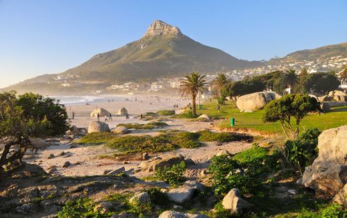
Top image: Kruger Park, Limpopo, South Africa © Rich T Photo/Shutterstock