Planning your own trip? Prepare for your trip
Use Rough Guides' trusted partners for great rates
- Algarve
- Portugal
written by
Olga Sitnitsa
The Algarve is Portugal’s southernmost region, stretching along the Atlantic coast from Vila Real de Santo António on the Spanish border to the cliffs of Sagres in the west. With a warm climate that lingers well beyond summer and some of the safest and most inviting beaches in the country, it is no surprise that this is Portugal’s most popular holiday region and home to many of the best beaches in Portugal.
Golden sands and turquoise waters are only part of the appeal. You’ll also find fishing villages where boats still unload the morning catch, dramatic sea caves, seafood served within sight of the ocean, and rugged inland hills scented with almond blossom in spring. If your tour of Southern Portugal includes the Algarve, expect more than just beaches. No matter if you want to surf the wild west coast, laze on sheltered coves, or wander whitewashed towns, the Algarve has more variety than its “beach holiday” reputation suggests.

Ponta da Piedade in Algarve © Fareharbor

Tips from Luis
Portugal Travel Expert

Hi! I’m Luis, your Portugal travel guide to the country’s sunny south, here to help you plan how to get here, what to see, where to stay, and the shortcuts that make exploring smoother. The Algarve’s blend of sweeping beaches, whitewashed towns, and dramatic cliffs is unforgettable, but knowing when and where to go makes all the difference.
Time it right and you will see why this coastline is counted among the best places to visit in Portugal. If you want to swim in turquoise bays, enjoy freshly caught fish on the harbor shore, or admire the sunset over the cape, then this is the place for you.
Luis's tip
If you want quieter beaches in summer, head west of Lagos before 10 am or after 5 pm. For a crowd-free lunch, look inland to villages like Monchique or Alte, where restaurants serve regional dishes for a fraction of the coastal prices. Renting a car gives you freedom, but keep coins for toll roads and small parking lots near hidden coves.
Best time to visit
Late spring (May-June) and early autumn (September-October) offer warm weather, calmer seas, and fewer crowds. July and August are hot, busy, and the most expensive months, with packed beaches from mid-morning. Winter is mild, quiet, and good for hiking or golfing, though some coastal restaurants close for the season.
How to get to the Algarve
Faro Airport has direct flights from across Europe and is the main gateway to the region. From Lisbon, trains run to Faro, Lagos, and Portimão, though buses are often faster. Driving from Lisbon takes about three hours and gives you the flexibility to explore small towns and beaches away from the main resorts.
Best areas to stay in the Algarve
The Algarve runs the length of Portugal’s southern coast, from Vila Real de Santo António on the Spanish border to the cliffs of Sagres at the country’s southwestern tip. Its coastline shifts from calm, golden beaches in the east to dramatic, wave-battered headlands in the west, with a patchwork of fishing harbors, resort towns, and quiet coves in between.
The region is also a gateway to some of southern Portugal’s most memorable experiences and an essential stop on any well-planned Portugal itinerary. You can wander the riverside streets of Tavira, explore the sea caves near Benagil, follow cliff-top trails at Ponta da Piedade, or head inland to Monchique for panoramic views over the entire coast.


Albufeira, Algarve, Portugal © Shutterstock
The Algarve covers a long stretch of coast, so getting between towns and beaches often means more than a quick stroll. Public transport connects the main hubs, but to reach hidden coves, inland villages, and cliff-top trails, a car offers the most freedom. If your trip to Portugal includes the Algarve, consider renting a car to explore beyond the main beach towns.

Faro town in Algarve, Portugal © Digital signal/Shutterstock
You can get a taste of the Algarve in two or three days by focusing on one part of the coast, such as the best beaches in the Algarve around Lagos or the historic streets of Tavira.
Four to five days lets you explore both east and west, combining relaxed beach time with visits to towns like Silves and Loulé, a boat trip to the Benagil Cave, and cliff walks at Ponta da Piedade. You can also fit in an inland drive to Monchique for panoramic views over the coast.
A full week or more gives you the chance to slow down and see the Algarve beyond its postcards. Spend time in fishing villages, try multiple hiking trails, explore the Ria Formosa by kayak, and enjoy quieter beaches that require a bit more effort to reach.

Beach of Camilo, Algarve, Portugal © Shutterstock
Accommodation in the Algarve ranges from sleek seaside resorts to family-run guesthouses in quiet inland villages. Your base will shape your experience: staying in a coastal town puts you steps from restaurants and boat tours, while inland stays offer peace, nature, and a taste of local life.

Albufeira, the Algarve, Portugal
From golden beaches and hidden sea caves to lively fishing towns and inland mountain trails, the things to do in the Algarve go far beyond a typical beach holiday. You can explore grottoes by boat, wander historic streets, taste fresh seafood by the water, or hike along cliffs where the Atlantic crashes below. This mix of coast, culture, and countryside makes the region one of Portugal’s most rewarding destinations.
A short drive from Lagos, Ponta da Piedade is a headland of weathered limestone cliffs shaped into arches, towers, and caves. The golden rock against turquoise water is a photographer’s dream, and the view from the clifftop paths is spectacular year-round. Stairs lead down to the base, but the most memorable perspective is from the water. Small boat tours and kayak trips take you through narrow channels and into grottoes lit by shafts of sunlight.
Mornings are calmest and less crowded, so aim for an early start. Wear good shoes for the paths, bring a camera, and take your time, every turn offers another jaw-dropping angle.
Perhaps the Algarve’s most famous sea cave, Benagil, is known for its vast dome-shaped chamber and the natural skylight that floods it with golden light. It’s only accessible from the water, and while boat tours are the most common option, kayaks or stand-up paddleboards let you linger and explore nearby coves. Swimming is risky due to strong currents, so stick to organised trips.
To avoid the busiest times, head out early in the morning or the last couple of hours before sunset. For a quieter launch point, consider nearby beaches instead of Benagil itself. Most tours combine the cave with other dramatic rock formations, so you’ll get more than just the headline act.
Regularly topping lists of Europe’s most beautiful beaches, Praia da Marinha is framed by soaring cliffs and crystal-clear water. Reached by a steep staircase from the car park, the beach is sheltered and ideal for swimming or snorkeling on calm days. The cliffs above have a marked trail leading to viewpoints and the famous double-arched rock formation: a must for photos.
At low tide, you can walk between small coves, discovering patches of sand tucked beneath the cliffs. Facilities are limited, so bring water, snacks, and an umbrella for shade. Go early in summer to find parking and a good spot on the sand, and don’t rush off, the sunset from the clifftop is unforgettable.
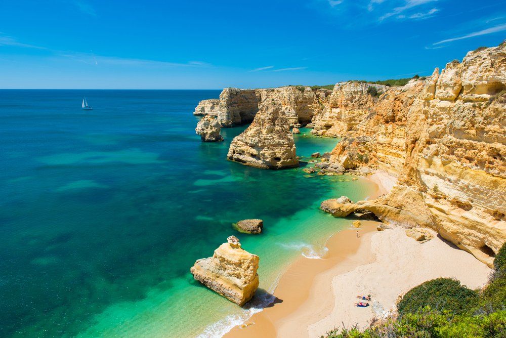
Praia da Marinha @ Shutterstock
Stretching along the eastern Algarve, Ria Formosa is a shifting landscape of lagoons, salt marshes, and barrier islands. It’s a paradise for birdwatchers, especially during spring and autumn migrations when flamingos, spoonbills, and ospreys pass through. Ferries and water taxis from Faro, Olhão, and Tavira connect to islands like Armona and Culatra, each with long, uncrowded beaches and fishing communities where you can eat fresh clams by the shore.
The park also has gentle walking and cycling trails, ideal for escaping the busier resorts. Visit with a local guide to learn about the traditional shellfish harvesting that still sustains many families here, and to spot wildlife you might otherwise miss.
Set inland along the Arade River, Silves was once the Moorish capital of the Algarve, and its red sandstone castle is the most impressive in the region. Climb the ramparts for sweeping views over the orange groves and rolling hills. Inside, an archaeological museum displays artifacts from Roman and Islamic periods, adding depth to your visit.
The old town below is a maze of cobbled streets, Gothic churches, and shaded cafés, perfect for a slow wander. Spring is especially beautiful when the citrus trees are in blossom, filling the air with fragrance. If you’re here in August, the annual Medieval Fair brings jousting, music, and market stalls to the castle grounds.
The southwestern tip of Portugal feels like the edge of the world. Sagres has a laid-back surf town vibe, while nearby Cabo de São Vicente is marked by a lighthouse perched above towering cliffs. The views are dramatic, with waves crashing against the rock far below and seabirds riding the wind.
The fortress at Sagres offers insight into Portugal’s Age of Discovery, when this coast was a launching point for explorers. Sunsets here are famous, and so are the winds, so bring a jacket even in summer. Many visitors include Sagres as a highlight on a tour of Portugal's cities and beaches, combining it with a drive along the rugged west coast for more wild beaches and coastal viewpoints.
One of the Algarve’s prettiest towns, Tavira straddles the River Gilão with a Roman bridge linking its two halves. Whitewashed houses, tiled façades, and church towers give it an elegant, unhurried feel. From the town, ferries run to Ilha de Tavira, a long sandy beach backed by dunes. In the old town, visit the castle gardens for views over the rooftops, explore small museums, and linger at riverside cafés.
Tavira is especially atmospheric in the evening when the streetlights reflect off the water. It’s also a great base for exploring the eastern Algarve and the quieter stretches of Ria Formosa.

Pousada Convento, Tavira, Algarve, Portugal @ Shutterstock
Rising behind the coast, the Monchique range offers a cooler climate, lush vegetation, and sweeping views. The spa town of Caldas de Monchique is known for its mineral water and 19th-century bathhouses, while the summit of Foia, the Algarve’s highest point, delivers 360-degree panoramas on clear days. Hiking trails weave through chestnut and eucalyptus forests, and roadside stalls sell local honey, smoked sausages, and liqueurs.
The area is particularly beautiful in spring when wildflowers carpet the slopes. For lunch, seek out a family-run restaurant serving mountain dishes like black pork or roasted chicken with piri-piri sauce.
This cliff-top walk between Praia da Marinha and Praia de Vale Centeanes is one of the Algarve’s most spectacular hikes. The 6 km route passes sea arches, hidden beaches, and limestone ravines, with constant views of the Atlantic. Allow three to four hours if you want to stop for photos and explore the coves. There’s little shade, so bring a hat, sunscreen, and plenty of water.
Spring and autumn are best for comfortable walking conditions, but in summer, an early start helps avoid the heat and crowds. You can also break the hike into shorter sections if you’re traveling with children or have limited time.
Loulé’s covered market is a lively showcase of Algarve produce and crafts. Beneath its Moorish-style arches, stalls overflow with fresh vegetables, cured meats, olives, cheeses, and local delicacies like fig and almond sweets. The surrounding streets are filled with shops selling cork goods, ceramics, and textiles.
Saturday mornings are the most vibrant, with farmers from nearby villages bringing their goods and street performers adding to the atmosphere. After browsing, take time to explore the old town’s narrow lanes, visit the 13th-century castle, or enjoy a coffee at one of the nearby cafés. Loulé makes a great inland day trip, especially if you want a break from the beach.

Ria Formosa © VisitAlgarve
The Algarve enjoys a warm Mediterranean climate with mild winters and hot, dry summers. Being on the southern coast, it gets more sunshine than most of Portugal, and the Atlantic keeps coastal temperatures from climbing as high as inland areas. Average highs range from 61°F (16°C) in January to 84°F (29°C) in August. Rain is scarce in summer but more common from November to February. Many travelers consider spring and early autumn the best time to visit Portugal, and the Algarve is no exception, with comfortable temperatures and fewer crowds in these seasons. For current conditions, check the IPMA (Portuguese Institute for Sea and Atmosphere).

Farol island in Formosa Estuary, Algarve, Portugal © Shutterstock
The Algarve’s dining scene blends ocean-fresh seafood, traditional Portuguese flavors, and a growing number of modern restaurants. You can eat grilled fish by the harbor, try petiscos in a tiled-backstreet café, or linger over a long lunch with ocean views. Inland towns offer hearty stews and slow-cooked meats, often paired with local wines.

Portugal Algarve Seven Hanging Valleys trail, lighthouse Farol de Alfanzina near Benagil © Shutterstock
Here are some unique experiences you can add to a tailor-made Algarve trip, all private, flexible, and designed by local travel experts.
Use Rough Guides' trusted partners for great rates
written by
Olga Sitnitsa