Southern Madagascar Travel Guide

Southern Madagascar has some of the island’s most compelling attractions: the gaunt sandstone plateau of Parc National d’Isalo, cut by oasis-like canyons; the towering mountain fastness of Parc National d’Andringitra, with its grasslands and moors on one side and almost unexplored rainforest on the other; the spiny forests and glorious beaches, surfing and diving of the dry southwest; and the seductive rolling landscapes, scalloped bays and diverse forest ecosystems of the far southeast, around the port of Fort Dauphin. This is also Madagascar’s poorest region, however, and more prone to lawlessness – generally manifested in cattle rustling and highway banditry – than the rest of the country.

The climate of the south is relatively more extreme than that of central and northern Madagascar. The Tropic of Capricorn carves through the region, and the dry southern or austral winter brings cooler weather from May to August than in the north of the island. Much of the southwest, spiny forest country, is also very arid, while facing the cyclones from the Indian Ocean, the beautiful forest of the southeast coast is bathed in moist air for much of the year.

Peoples of the south

The Malagasy peoples of the south talk in a range of dialects of Malagasy, united (like the English language) by the one written version. Even more than in other parts of the island, these ethnic groups managed to avoid domination by the highland Merina in the nineteenth century, and even retained much of their autonomy during the six decades of French rule in the twentieth century.

One of the country’s most distinctive ethnic groups, the Bara range across the dry interior of the southwest. In this region, three traditional kingdoms strongly resisted French rule, mounting a ten-year rebellion, crushed by the execution in 1907 of one of their kings, Lahitafika. By tradition exclusively cattle herders, with a strong claim to African origins, Bara herders are often seen moving their livestock along the RN7 between the sapphire town of Ilakaka and their de facto capital, Ihosy. The inter-clan cattle-raiding that once characterized Bara society, in which every young warrior was expected to participate, has also earned them a reputation as restless bandits (dahalo), preying on vehicles when herds aren’t there for the taking.

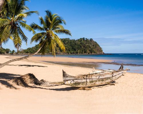
To the west of Bara country and scattered all along the southwest coast – mostly between Morondava and Tuléar – live the Vezo, whose name literally means “Paddle!”. They are fishing people, and tend to live in villages right on the beach, using their dugout canoes (with a single outrigger of light wood) to take their nets out to the fishing grounds. While their ancestral origins are linked most closely with those of the herding, farming and trading Sakalava, Vezo identity is tied so closely to the seafaring, fishing and seafood-selling lifestyle that those who cease these activities stop considering themselves Vezo. At the same time, Mahafaly or Antandroy incomers who paddle and fish are soon assimilated as Vezo.

In the far southwest interior, the Mahafaly (literally “the fady-makers”) were little influenced by Merina rule, instead seeking French protection to keep control of their main town, Tuléar. Cultivators and pastoralists, they are also traditionally adept craftspeople, renowned for their woollen rugs and woodcarvings. They’re particularly famous for their funerary sculptures known as aloalo. These intricately detailed and painted posts, depicting the life and times of the deceased, used to feature mostly naked figures, and were all about the world of the ancestors: today they act as carved obituaries, full of cattle, cars and symbols of achievement.

In the remote far southeast, in the hinterland of Fort Dauphin, live the Antandroy (“People of the thorns”), with a closely related group, the Antanosy, forming a large part of the population of Fort Dauphin itself. Traditionally livestock herders, they now also eke out a living from rice and cereal farming, and as seasonal migrant labourers. The Antandroy are renowned weavers, and build large whitewashed concrete tombs, elaborately painted and decorated with tiles.

Parc National d’Andringitra

On the southern edge of the central highlands, the spectacular landscape of the 310-square-kilometre Parc National d’Andringitra looms up between the RN7 highway and the east-facing escarpment that drops to the coast, 100km away. Only created in 1999, the park has sharply divided ecosystems, from forest and grassland on the northern and western sides, where there’s a notable dry winter season, to mountain moorland around the bare granite peaks, to remote ravines tangled with rainforest on the eastern slopes. Andringitra is extraordinarily rich in wildlife, with 13 species of lemurs, more than 30 other mammals, 106 species of birds, 35 reptiles, no fewer than 57 species of frog and at least 1000 species of plants and trees.

You should be prepared for rain throughout the year (especially higher up) and for low temperatures at night.

Trails

Most of the park circuits start at the Namoly Gate in the east. Walks in the west mostly take place outside the park proper but give you great views and ring-tailed lemur encounters. Walking west to east (from the Morarano Gate in the west to Namoly) or vice versa takes a minimum of two days in each direction.

The trails in the park are mostly in good condition, but they’re long and quite arduous. The easiest is the Circuit Asaramanitra, a 6km loop (plus the 4km access trail from the Namoly Gate) which takes a good half-day to complete, including a visit to the base of the Riandahy and Riambavy falls, just 500m apart. To the east, the 8km Circuit Imaintso (plus a 7km access trail from the Namoly Gate) loops through primary rainforest.

Diavolana trail

If you have a full day and make an early start, you could do the Circuit Diavolana. This 13km route through a range of climate zones runs below the cliffs, above the waterfalls, and finishes at a campsite. As you climb, the landscape becomes increasingly Lord of the Rings, with streams tumbling through the rocky grassland, stone-walled Betsileo tombs tucked into clefts in the mountain and the vast, curtain-like folds of the higher altitudes creating a looming backdrop that never seems to get any closer – until suddenly the cliffs are right above you.

Imarivolanitra trail

With two or three days available, you could tackle the tough, 28km Imarivolanitra trail, which takes in the 2658-metre summit of the same name. The second highest point on the island, it’s still more often known by its old name, Pic Boby, so called after a French hiker’s dog that went missing up here in 1920. To reach Pic Boby at sunrise, you’ll need to leave the plateau camp by 3am.

Wildlife

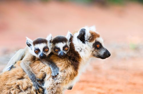
Although the park is extremely biodiverse, its wildlife isn’t always easy to see and the greatest number of species is found in the inaccessible eastern rainforest. Andringitra’s most emblematic species is the ring-tailed lemur (Lemur catta) and you’ll invariably encounter ring-tails at Camp Catta, as well as higher up in the mountains. Other lemurs – all found in the eastern forests – include the red-fronted brown lemur (Eulemur rufifrons) and red-bellied lemur (E.rubriventer), Milne-Edwards’ sifaka (Propithecus edwardsi) and the greater bamboo lemur (Prolemur simus).

Birdlife

Outstanding birdlife includes the handsome and relatively common Madagascar blue pigeon (Alectroenas madagascariensis), with its distinctive red tail, and the much less easily seen, hook-billed and stump-tailed yellow-bellied sunbird-asity (Neodrepanis hypoxantha), which is like a diminutive flying lemon, flashing through the high forest.

Reptiles and amphibians

Andringitra’s most notable chameleon, found in bushes in the high-altitude grasslands, is the unmistakeably jewel-like Campan’s chameleon (Furcifer campani), with its three lateral stripes and multicoloured scales. Above the tree line, look out for two Andringitra endemics – the mottled mountain climbing frog (Anodonthyla montana), which breeds in rainwater puddles in the granite and can often be found tucked under stones, and the prettily green-patterned Andringitra bright-eyed tree frog (Boophis laurenti), which makes do with heather bushes for trees and breeds in fast-flowing streams above 2000m.

Parc National d’Isalo

The popularity of the Parc National d’Isalo owes much to its location, midway between Fianarantsoa and Tuléar, and its accessibility, straddling the RN7 highway from Antananarivo. This 810-square-kilometre sandstone plateau is a dramatic spectacle, its towering mesas and sculpted pillars creating a desert-like, Monument Valley-style landscape that is especially striking at its southern extremity, where the tarmac highway twists past the cliffs. Cut by streams and springs into countless, sandy-floored, oasis-like canyons, filled with forest, with several alluring natural swimming holes of cool, crystal-clear water, the whole region offers tremendous scope for hikers and anyone aiming to escape the blasted heat of the prairies of the high plateaux. The park ranges from just over 500m up to 1268m above sea level and the canyons are in places as much as 200m deep.

Scenery aside, Isalo is less convincing as a wildlife destination: although still blessed with 14 species of lemur, 77 varieties of birds and more than 400 species of plants, there simply isn’t the range of ecosystems here to support the fabulous riches of some parks. Culturally, however, the region is richly endowed. This is the heartland of the Bara people, believed by some anthropologists to have come from mainland Africa. Their traditions, including the cult of warriorhood and pogo-like ritual dances, are similar in some respects to those of the Maasai cattle herders of Kenya and Tanzania. One of the old Bara clans’ royal family seats is at the village of Ampika, by the mouth of the national park’s Canyon des Makis. Bara burial caves are still scattered in canyon walls throughout the plateau, and in the far north of the massif, sixteenth-century Portuguese explorers are said to have married Bara women and lived in cliff dwellings – a good story for which there’s scant evidence.

The park headquarters is at the town of RANOHIRA in the park’s southeast corner.

Interpretation Centre

For an interesting introduction to Isalo, visit the interpretation centre, 10km southwest of Ranohira, a small museum on the south side of the road, which explains the geology and ethnology of the area. There are photos of the tomb of King Ramieba, the last Bara king, ensconced in a rock cleft, with one of his guards shown in Napoleonic headgear.

Trails

Isalo has several standard options for brief and extended day walks, as well as multi-day camping circuits. Most of them are helpfully marked with point métrique stones at 50m intervals, though you will be accompanied all the time by a park guide, so you can’t get lost, or bite off more than you can chew. Nevertheless, take a good hat and carry enough water: above the cool canyons, the trails on the plateau can be hot and steep.

Namaza Trail

The easiest trail, the Namaza Trail (up the stream and canyon of the same name, 1.5km in each direction) starts at a car park 4km northwest of Ranohira. From here, the easy footpath runs for 800m through the beautiful Namaza valley to the Namaza campsite. Even at the height of the dry season, pretty greens and yellows fill the canyon, with purple-flowering Koehneria flowers, related to purple loosestrife, everywhere. After a further 700m, with a little climbing (60m gain), you reach a beautiful, cool pool at the base of dark cliffs, where the Cascade des Nymphes waterfall tumbles from the plateau above, and you can swim.

Circuit Piscine Naturelle

The well-known Circuit Piscine Naturelle (Natural Swimming Pool Trail; 3km from the car park to the pool in each direction), starts from a car park 3.5km west of Ranohira (the turning is on the south side of town, by the Toiles d’Isalo hotel). From the car park, the footpath ascends 70m over the Isalo plateau before dropping after 3km to the pool itself, the largest and most popular in the park, with its fringe of Bismarck palm trees. From the pool, a 3km path running northwards across the plateau descends (180m drop) to the Namaza valley, enabling a circuit to be made.

Canyon des Makis and Canyon des Rats

In the northeast side of Isalo, two spectacular clefts into the side of the Isalo Plateau, the Canyon des Makis (maki: ring-tailed lemur in Malagasy) and the Canyon des Rats, are accessed by a 13km dirt road along the Manamaty river valley from the RN7, starting just northeast of Ranohira. The Canyon des Makis is the southernmost and easiest of the two: starting from its car park, you take the footpath for 1km or so, crossing a couple of streams and irrigation ditches and then cutting through fields and gardens, before breaking through a tangle of bush at the mouth of the canyon to emerge in the glorious ravine. Here, multi-directional sunlight bounces off the orange sandstone walls, illuminating the stream and pools on the canyon floor, where lush flora bursts from the damp ground against a backdrop of dripping water and little rainbows fizzing over moss-covered boulders.

The mouth of the Canyon des Rats is just 700m to the north of the Canyon des Makis, though you’ll need a long half-day to do justice to them both (including driving time). Alternatively, explore the Makis canyon, then walk the 6km trail that starts from further up the canyon and runs southwards through the park to join the Circuit Namaza.

Flora

Isalo’s plants and trees are some of its most distinctive natural assets: spiky and fan-like Bismarck palms (Bismarckia nobilis; satrana in Malagasy) are scattered across the landscape in this, the heart of their natural habitat (the Bismarck is now found all over the world, and particularly popular as a garden tree in the suburban canyons of Southern California). More unusual is the extraordinary elephant’s foot (Pachypodium rosulatum, or vontaka in Malagasy). It looks like a stumpy little baobab with pipe cleaners for branches until it bursts into yellow flowers at the end of the dry season. You’ll see it on the canyon walls on the Circuit Piscine Naturelle.

Fauna

As for animal life, while lemur sightings in Isalo are likely to be either far off away on the cliff sides, or scampering with rather too much familiarity around one of the campsites, the park does have some interesting denizens. You’re almost certain to see ring-tailed lemurs in the more open, rocky areas, and in the forest Verreaux’s sifakas (Propithecus verreauxi) are also likely. Look out, in and around the streams and pools, for the regionally endemic large western white-lipped tree frog (Boophis occidentalis) that’s often encountered around the Cascade des Nymphes. If you see one, you’re more likely to notice its red webbed feet than the colour of its lips. Also keep your eyes open for the very rare, strikingly green-black-and-red-marbled painted burrowing frog (Scaphiophryne gottlebei) – a species that is strictly endemic to Isalo and critically threatened by collection for foreign frog fanciers. Among Isalo’s seventy-odd birds, keen ornithologists won’t need reminding about the robin-like Benson’s rock thrush (Monticola sharpei bensoni) for which the park, and especially the plateau top above the Namaza trail car park, is a key habitat.

Ilakaka and Sakaraha

IKAKAKA and SAKARAHA, the two towns nearest to Zombitse National Park, have boomed on the highway from almost nothing over the last twenty years, as rural migrants have arrived seeking fortunes from mining for gems – particularly the sapphires of which this region is now the world’s biggest producer. The fortified emporia of Sri Lankan gem traders and others line the streets of each town – pure Wild West, and none too welcoming. Sakaraha has a new bank with a useful ATM, the only one between Tuléar and Ihosy.

Parc National Zombitse-Vohibasia

Unexpectedly, the relative monotony of the RN7 highway is broken where it plunges through a large tract of dry forest, the Parc National Zombitse-Vohibasia, a ragged zone of patches of western deciduous woodland that also incorporates some of the southern, spiny forest flora. Among the generally low trees are two baobabs, Adansonia za and A. madagascariensis, and a wide range of wildlife. Although declared a national park in 1997, maps of the area at the time show how much forest has been felled since then, especially on the western side nearer Sakaraha. While not a must-see, the small, accessible sector of Zombitse is very easy and comfortable to visit: the wildlife here is more prolific than in Isalo and you’ll generally have the wide, flat trails to yourself.

The park is separated into the southern Zombitse area (around 160 square kilometres), most of which is north of the RN7 and hard to visit, and the northern Vohibasia area (around 200 square kilometres), which is further north still and more or less inaccessible. Get to Zombitse as early as possible for the best wildlife – especially if you want to spot Appert’s tetrakas foraging.

Trails

If you only have an hour or two, follow the 500m loop of the Circuit Ritikala on the south side of the RN7 highway. The 5km Circuit Lobo is an eastern extension of the same Ritikala trail, for which you should allow half a day, with an early start. The Zombitse sector’s northern trail, on the north side of the road, is the Circuit Mandresy, for which you should allow a good three hours.

Wildlife

One of Madagascar’s rarest birds, the largely terrestrial warbler, Appert’s tetraka (Xanthomixis apperti, also known as Appert’s greenbul), has its last main refuge here; it can usually be seen in the undergrowth along the Circuit Ritikala. Naturalists also visit for a green-and-gold coloured endemic lizard of the southwest, the Standing’s day gecko (Phelsuma standingi), usually seen in pairs on larger tree trunks, and eight species of lemurs, including ring-tails and the relatively habituated Verreaux’s sifaka.

The one lemur to look out for, though, is the Hubbard’s or Zombitse sportive lemur (Lepilemur hubbardorum) – only identified in 2006 and endemic to the forest (the sportive lemurs here were formerly considered to be the red-tailed species, L. ruficaudatus). Once you get your eye in, Hubbard’s are easy to see by day, peering – orange-eyed and splay-fingered – from their low-level tree holes. The star of the forest is the nimble, noisy, squirrel-sized pale fork-marked lemur (Phaner pallescens), which you may manage to see if you’re lucky and get to do a night walk, though it’s almost impossible to photograph as it bobs and dashes through the branches.

Réserve Privée Berenty

The bumpy 90km road to the Réserve Privée Berenty passes though a fascinating range of natural habitats, from the moist forest of Fort Dauphin into the spiny forest environment of the lower Mandrare River, with stands of impressive Adansonia za baobabs along the way. Further upstream beyond a sea of sisal plantations, lies the small town of Ifotaka en route to the heart of Antandroy country.

Renowned as the site of primatologist Dr Alison Jolly’s ground-breaking research on the female-dominated social life of lemurs, the Réserve Privée Berenty covers just 2.5 square kilometres of gallery forest, including some massive Indian tamarinds (Tamarindus indica), along the west bank of the Mandrare River. Amid vast plantations of spiky, cactus-like sisal plants, this iconic reserve, with its broad, well-maintained footpaths, is still considered a must-go by many visitors to Madagascar for its photo opportunities and the sight of “dancing” sifakas. Although the native ring-tails and Verreaux’s sifakas are indeed very habituated and happy to frolic among every new busload of visitors, Berenty is far from being any longer the only place to see these species (Nahampoana is increasingly good), and nor is it representative of natural lemur society in the wild. Reservations aside, it’s still a wonderful place, and remains one of the world’s leading primate research centres.

Other lemurs at Berenty include the little white-footed sportive lemur (Lepilemur leucopus) a nocturnal species that you’ll often see in its low tree holes by day, and a hybrid population of introduced red-fronted brown and red-collared brown lemurs (Eulemur rufifrons and E. collaris). The reserve also has a spectacular roosting site of the giant fruit-eating bat, the Madagascar flying fox (Pteropus rufus). Roughly 1000 of these bats, with wingspans of 1m, take off at dusk each evening on their nightly fruit-foraging missions.

Sainte Luce Reserve

Some 30km northeast of Fort Dauphin as the crow flies lies 4.3 square kilometres of precious littoral forest – humid coastal forest, swamp and grassland that thrives directly behind the seashore. It doesn’t sound much, but it’s a highly important area for some of southeastern Madagascar’s rarest endemic flora and fauna and contains within it the half-square-kilometre Sainte Luce Reserve, named after the huge bay to the north, whose name dates back to a group of seventeenth-century French settlers. As well as the forested area itself, meandering creeks ribbon their way from north to south, roughly parallel to the coast, as far south as the Baie de Lokaro, creating what is in effect a long, slug-shaped, inshore island of rare habitat. Managed on a shoestring by a local NGO coordinated by an Australian resident, the conservation work here benefits the district’s wildlife as well as the local fishers and farmers who live in the three villages of Ambandrika, Ampanasatomboky and Manafiafy, together known as Sainte Luce. If you’d like to make some positive contacts with local people, then a visit to Stitch Sainte Luce (w stitchsainteluce.yokaboo.com), an embroidery workshop set up by the NGO Azafady, is highly recommended.

Flora and fauna

The flora in and around the forest is dominated by buttress-rooted pandanus palms, and includes mangroves and the very rare Sainte Luce palm (Dypsis saintelucei) of which only around 100 mature individuals survive. These palms are critical to the survival of the jewel-like day gecko Phelsuma antanosy, which normally glues its two eggs to them. On the boggy grasslands on the shores of glassy Lac Ambanjika, and alongside the creeks (target of delightful boat trips from the Manafiafy Beach & Rainforest Lodge) live a variety of fascinating, acid-tolerant carnivorous plants, including pitcher plants (Nepenthes).

The S9 (“Ess-neuf”) forest, visited for walks by the lodge, is cut by easy-access, flat paths, and home to the large, diurnal red-collared brown lemur and nocturnal southern woolly (Avahi meridionalis) and rufous mouse lemurs (Microcebus rufus), among others. On a night walk, you’re also likely to see some very large sleeping warty chameleons (Furcifer verrucosus) and cute, roosting pygmy kingfishers (Corythornis madagascarensis), perched at the end of branches to protect themselves from snakes.

Fort Dauphin and around

Hilly and multifaceted, FORT DAUPHIN (pronounced colloquially in the Antanosy dialect as “Faradofay” or even “Farady”, but officially known as Taolagnaro) is a complete surprise. Well off the usual tourist routes, with no easy road connections to the rest of the island, this is a breezy, subtropical port where forest-cloaked mountains rise steeply above brackish lakes, and the old town centre shelters behind an indented peninsula, sprayed by the surf of the southern Indian Ocean and fringed by glorious beaches.

Fort Dauphin was the first French toehold in Madagascar, named after the future King Louis XIV in 1642 by settlers from the Compagnie des Indes Orientales. Today, with its mix of squalid poverty and manicured streets (in parts you could be in a French provincial town), Fort Dauphin reflects its colonial past, a wealthy new cosmopolitanism, and the austerity of the hard-pressed deep south of Madagascar, with its steady migration of rural migrants to the towns. Many here are looking for job opportunities with Rio Tinto’s huge titanium mine on the outskirts of town, run by a local corporation called QMM, or at the new port of Ehoala.

For visitors, there’s plenty to do and some excellent places to stay. There’s a fine, equable climate too, with lots of sunshine. The rains are heavier from November to March and there are scattered showers through the rest of the year.

Fort Dauphin has two main centres – the milling shanty town bisected by the road from the airport, and the sleepier administrative quarter near the old port.

Beaches

The town beaches are the gorgeously sheltered Libanona Plage on the west side of the peninsula, which gets busy at weekends, and the surfers’ Plage Monseigneur on the east side, which is much more exposed. Plage Ankoba, west of Libanona, also has good surf but can be dangerous. There are several other beaches around the peninsula, and the Talinjoo hotel has a virtually private cove of its own.

The Baie de Lokaro

Lokaro, some 25km northeast of Fort Dauphin, behind the four-peaked peninsula you can see on the horizon, is a perfect 1.5km triple crescent of golden sands backed by dense coastal forest and sheltered from the ocean by rocky outcrops. The craggy islet of Nosy Lokaro is joined to the far end of the beach at low tide. The Baie de Lokaro is the top out-of-town getaway for wealthier locals and expats, though there is nothing in the way of infrastructure – you need to bring all provisions and water. Several hotels in town, including the Lavasoa and the Talinjoo, have simple beach annexes at Lokaro, though these tend to function at weekends, or when booked, rather then being open all the time.

Parc National d’Andohahela

Fort Dauphin’s local “serious” park, Parc National d’Andohahela is a richly varied and mountainous patchwork of three separate districts, or parcelles, in the remote interior. From east to west these are: parcelle I, taking in 630 square kilometres of humid mountain rainforests along the Anosyennes range; parcelle III, a small transitional zone of just 5 square kilometres just to the north of the highway; and finally the 124-square-kilometre arid, spiny forest of parcelle II to the west, in the mountains’ rain shadow. After bandit attacks in the early 2000s, the park was subject to foreign government advisories for a number of years and closed in 2012. Security has improved and the park is open once again, but it is still little visited, and usually only as a day-trip with a Fort Dauphin tour operator as on-the-spot facilities are extremely limited. It is possible to camp if you bring all your supplies.

Wildlife at Andohahela can be a little thin on the ground, though lizards are plentiful enough, and there’s a good chance of seeing ring-tails (Lemur catta) and Verreaux’s sifaka. Hikes include the Tsimelahy trail (roughly 2hr), which passes through the transitional zone between humid and dry forest. You can also hike west of Tsimelahy to the village of Mangatsiaka (8km), which steadily moves out of transition vegetation and into the spiny forest typical of southwest Madagascar.

Tuléar and around

Sheltered on what were once mud and sand flats behind straggling stands of mangroves, the port of TULÉAR (also known as Toliara or Toliary) is not the most prepossessing place in Madagascar. This former slaving port has been sidelined by recent history – a fact reflected in the rebellious political stance often taken by the townspeople to matters being decided in Tana. Trash abounds here, especially around the outskirts, and there’s very obvious poverty, with begging quite widespread and frustrated pousse-pousse men looking for fares. Like an island of impoverishment in a sea of destitution, the town is barely able to look after its people, with insufficient support for its basic municipal services from Antananarivo and not enough wealth trickling down through jobs and market forces. There’s a new Chinese cotton factory out near the airport, but people here lament the complete lack of any local enterprises that contribute significantly to employment. The hinterland is barren and dry for most of the year – cotton, cattle and goats and a little subsistence agriculture are about all it can support and the drift of rural migrants to the town is ceaseless.

In practical terms Tuléar is a bit of a backwater, too. Although it’s connected to Tana by the country’s best road, the drive of at least 20 hours just serves to emphasise how dislocated it is from the rest of the country. Assuming the picture that’s forming hasn’t put you off coming here completely, you’ll find that there are one or two things to do in town apart from heading out of it. As you wander around Tuléar, look out for the town’s zebu carts, sometimes painted with bright, symbolic imagery derived from popular culture – typically music and film stars – and whose young charioteers will invariably stop to be photographed for a modest fee.

Tuléar has no real beach to retain tourists passing through. Batterie Plage, on the northwest side of town – site of British gun emplacements from World War II – is a working beach of windswept dunes that has also attracted notoriety for attacks on tourists. One to avoid.

Arboretum d’Antsokay

The best attraction in Tuléar is the Arboretum d’Antsokay, a 25-acre patch of managed spiny forest heavily planted with the flora from a lifetime’s botanical collecting by its Swiss founder, Hermann Petignat. The fascinating hour-long guided tour, made all the better by engaging guides (some of whom speak good English), starts – or ends, depending on whether you follow the numbered route or do it in reverse – in a neat and well-lit mini-museum. As well as geological samples, fossils and relics (including a giant Aepyornis egg), displays include musical instruments (note the two guitar-like kabosy on the left, a lokanga fiddle and a large zither or marovany on the right) and various local crafts.

The arboretum

Along the arboretum’s footpaths, there are some 900 species of plants, more than 80 percent of which are endemic to southwest Madagascar. Among them have been recorded 34 species of birds and 25 species of reptiles – although as the animals are free to come and go, sightings vary depending on the weather and the time of year.

Look out for the arbre vazaha (Commiphora) that “peels like a European”, and the baobabs from Morondava that are 30 years old yet only a metre or so tall. Further along, notice the stick-like green euphorbia, which has a toxic, adhesive white sap, and the famous octopus tree (Didierea madagascariensis), with its trailing leaf-and-spine-covered limbs, so characteristic of the southwest. Keep an eye out too for the beautiful jabihy or “natural bonsai” (Operculicarya pachypus); the strangely shaped succulent known as “Napoleon’s hat” (Kalanchoe beharensis); and the amazingly unclimbable Pachypodium lamerei, with its fearsome armour of tri-pronged spines (what, you wonder, is it so afraid of?). As you walk, you’ll see natural spiny forest beyond the park’s boundary.

Ethnology trail

Finally, back near the office and museum, is the absorbing ethnology trail, or sentier ethnologue, where exhibits demonstrate plant use in traditional culture and include the nazo manga (“blue wood”) posts put before a chief’s house. The hut-like houses of the local Antandroy cattle herders, of which an example is on display, are typically made of the ocotillo tree (Alluaudia procera; or fantsiolitse in Malagasy), a young specimen of which is growing outside the house.

Anakao and around

While it is more or less inaccessible by road, the beach area around the Vezo fishing village of ANAKAO, 30km south of Tuléar across Saint Augustin Bay, is one of Madagascar’s favourite getaways for locals and low-budget travellers – and increasingly for more upmarket visitors too. Be prepared for the lack of infrastructure at Anakao beyond the hotels’ compounds: the local poverty often jars uncomfortably with carefree tourism, as does the obvious lack of toilet facilities for villagers with enjoying the beach itself.

Nevertheless, the main attractions of this area, where scrubby dunes meet ocean, are the simple pleasures of sun and sand. The area is getting a world-class name for surfing and wind- and kitesurfing rather as much as snorkelling and diving, though marine life can be very worthwhile and the water conditions are usually good. Whale-watching is also good here during the migration season, from July to September. And if you’re interested in local culture, you’ll find the big painted cement tombs of Vezo ancestors, near the point, fascinating.

North of Tuléar

As you head north along the coast out of Tuléar, the road starts unpromisingly, with acres of rubbish and landfill. After crossing the Fiherenana River and passing a quite demanding police barrier, it’s rocky, sandy and corrugated. Although the route runs very close to the seafront, don’t expect a tropical beach paradise: much of the zone immediately behind the beach is degraded scrubby bush and overgrazed goat lands. You’ll pass the occasional turning to a beach hotel, and several straggling small settlements, one or two of which will try to waylay you with rickety stalls of sea shells and dried marine specimens.

Ifaty, Mangily and around

Eventually the road bypasses the small fishing village of IFATY (25km from Tuléar) and reaches the coconut groves and scattered wooden bars and shops of MANGILY centre 3km further on. From here, various tracks trail through dry fields and over the dunes to the beach (about 500m) and inland into the bush. As a beach getaway the area plays second fiddle to Anakao and beach vendors can be a nuisance. The main attraction is the beach hotels themselves, some of which are very nice – and the more questionable appeal of Mangily’s watering holes – though the barrier reef here is extensive, and there’s great snorkelling and diving to be done (and the chance to learn if you’re a novice).

Baie de Ranobe coral reefs

The brightest note in this area is focused on the undersea world. A voluntourism reef-diving NGO, ReefDoctor, based on the north side of Ifaty village, works on community-based reef conservation the length of the Baie de Ranobe, the 26km lagoon behind the barrier reef between Ifaty and Manombo. With local participation, they have created the small marine reserves of Andabotira, Ankarajelita and Massif des Roses, which visitors can dive.

Reniala Forêt de Baobabs and around

Several areas of the original wild spiny forest in the Mangily area have been fenced and commercialized as wildlife reserves for guided visits. The largest, though less than 1 square kilometre – and also generally the best reviewed – is the Reniala Forêt de Baobabs, which incorporates a labelled plant trail and bird reserve. The park is open from dawn to dusk, though you should check in with the office by the main road the evening before if you want to make a really early start.

The standout flora here are the baobabs (reniala means baobab in Malagasy), with roughly a thousand specimens of the smooth, cylindrical Adansonia rubrostipa, and the fantastical, cactus-like Didierea family of octopus trees and their relatives, with their tiny leaves and fearsome spines, for which the spiny forest is named, and which are endemic to southwest Madagascar. Lemurs include the attractive little nocturnal grey-brown mouse lemur (Microcebus griseorufus), while the endemic birds highest on every self-respecting birder’s list are the very rare Madagascar plover (Charadrius thoracicus), the very localized red-shouldered vanga (Calicalicus rufocarpalis), the sub-desert mesite (Monias benschi) and that would-be roadrunner, the long-tailed ground roller (Uratelornis chimaera) – though increasingly you’ll need to be lucky to see the last named.

Sharing an entrance off the RN9 with the Reniala Forest on the north side of Mangily are two other parks, the Spiny Forest Ifaty Private Reserve (t 034 36 579 72 or t 033 85 549 44) and the Réserve du Parc Mosa (t 034 36 579 72 or t 033 85 559 44; guided visits from 15,000ar depending on trail and subject of interest).

Village des Tortues

Different from the other reserves is the Village des Tortues, a highly recommended 7-hectare private sanctuary and conservation project for the big radiated tortoise (Astrochelys radiata) and diminutive spider tortoise (Pixys arachnoides). Visits among the baobabs, euphorbias and strangely shaped Didierea are accompanied by guides from the sanctuary, and as well as free-roaming adults you can see hatchlings in the nursery areas.

The spiny forest

The strangest biome of all Madagascar’s ecosystems is the spiny forest, which covers more than 14,000 square kilometres of the country’s southwest and is unique to this corner of the planet. With its multitude of strange forms, including spine-covered tendrils, bulbous stalks and fleshy, cactus-like lobes, the xerophytic (dry-loving) flora of this tangled, alien environment is utterly distinctive – more like the studio set from an early episode of Star Trek than natural vegetation. The forest occurs naturally in this arid landscape, sheltered from the drenching cyclones of eastern Madagascar by the central mountains.

The key plant types in the spiny forest are a brilliant variety of succulents – the euphorbias – as well as the stumpy, triffid-like pachypodiums, the baobabs and dozens of species of a family endemic to Madagascar, the spine-possessed Didiereaceae, which are almost encased in ruthless, hard spines and which can grow to 15m in height.

But the spiny forest isn’t all about the plants: it’s also about the animals that, bizarrely, flourish among them. While the animal life is not as prolific or diverse as the rainforest, this is still a rich and rewarding ecosystem for any amateur naturalist. Iguanas and day geckos, chameleons and tortoises, flightless birds, bats, spiny tenrecs (a family of primitive, shrew-like mammals), all make their home in this dessicated environment, extracting moisture from plants refined by evolution to retain it.

Lemurs are widespread, too, and none seemingly more unsuited to a home amid the thorns than the waif-like Verreaux’s sifaka (Propithecus verreauxi). And yet this cuddly toy of a primate, with its soft inquisitive fingers, seems quite at home clinging vertically to the spine-covered green spears of a giant Allaudia ascendens. What still perplexes primatologists is that the sifakas are able to hurl themselves from spiny trunk to spiny trunk, grasping and landing between the closely set clumps of vicious needles, and are never seen to stab a toe or get a painful surprise in the backside. If you want to witness this compelling phenomenon yourself, the best place to do so is in the Anjapolo part of the Réserve Privée Berenty and at Mangatsiaka in Parc National d’Andohahela.

Morombe

You’re very likely to stop the night at the small town of MOROMBE, effectively the Vezo capital, if you’re en route by taxi brousse between Morondava and Tuléar. With the Mozambique Channel on one side and mangroves and tidal flats on the other, it’s almost an island – a couple of sandy, parallel streets back from a beach strewn with boats and fishing nets, and flecked with fish scales. Morombe is the Majunga or Morondava of fifty years ago – remote, isolated and, since the cancellation of Air Madagascar flights, a little forgotten.

Planning your own trip? Prepare for your trip

Use Rough Guides' trusted partners for great rates

Andy Turner

written by Andy Turner

updated 26.04.2021

Ready to travel and discover
Madagascar?

Get support from our local experts for
stress-free planning & worry-free travels

Plan my trip ⤍