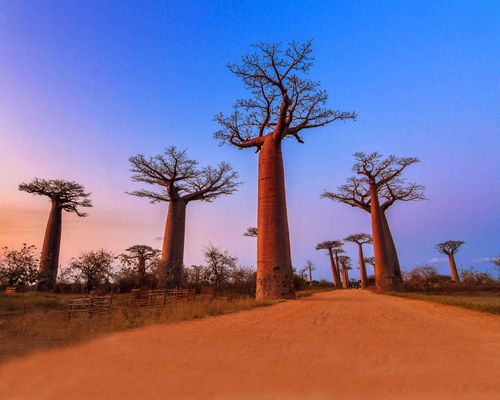
Nosy Be and around
The island of Nosy Be (“Big Island”) presides over Madagascar’s tourism industry like a brightly cloaked magician, conjuring perfect holidays out of the seductive natural environment and putting most visitors under a deep spell. It is also one of the island’s most natural choices for a Madagascar luxury tour, with its blend of tropical scenery, island atmosphere and well-established visitor comforts.
Indian Ocean traders have been visiting and settling on the island for centuries, but it jumped onto the world stage in 1841 when the queen of the Boina Sakalava tribe invited the first colonial rule in Madagascar by calling on the French to help her people against their Merina oppressors on the mainland.
An imperial governor, Admiral de Hell, was installed, and French and Réunionais Creole settlers followed soon after.
For the vast majority of today’s visitors, arriving on direct flights from France or seasonal charters from Italy, this is the only part of Madagascar they ever see. With its fringe of glorious beaches along the west coast, you can see why: arriving in Nosy Be’s primary-coloured landscape, with its deep-blue sky and opalescent sea, golden sands, and tropical verdure draped with purple bougainvillea, is a tonic for greyed-out Europeans. It’s the kind of lush environment where fence posts sprout leaves and turn into hedges. And the sensual perfume of ylang-ylang flowers is everywhere.
All is not perfect however. Since the demise of the ylang-ylang perfume distillery and the SIRAMA state-run sugar plantations at the turn of the century, Nosy Be’s inhabitants rely increasingly on tourism. This has its dark side: prostitution and exploitation are evident in some resort areas, and the brutal murder of two Europeans in 2013 saw a slump in tourism from which the island has yet to recover.
None of this is likely to have any impact on your stay: the beaches and marine life are still beautiful, the interior is an underrated bonus and the surprisingly remote Lokobé rainforest is a real draw for wildlife enthusiasts. Nosy Be itself is just the largest of more than twenty islands scattered in the Mozambique Channel off Madagascar’s indented northwest coast, several of which have inviting lodges.
The Donia festival
Nosy Be’s biggest cultural event of the year is Donia (w festival-donia.com), a 4–7-day music and cultural festival at the end of May, celebrating the unity of the peoples of the western Indian Ocean. It focuses on music shows at several different venues, including Hell-Ville stadium, where up to 20,000 people cram to watch acts from Mauritius, Réunion, Rodrigues, the Comoros and Madagascar, as well as from francophone mainland Africa.
Peoples of The far north: The Antankarana and Tsimihety
The people of the region with the best claim to be its indigenous inhabitants are the Antankarana, the “people of the rocks” – a reference to the widespread scenery of limestone pinnacles or tsingy. With a long history of trading contacts with Arabia, East Africa and especially the Comoros, the Antankarana were some of Madagascar’s earliest converts to Islam, incorporating the teachings of the Koran into traditional customs. By the early eighteenth century, however, they had mostly become subjects of the much more numerous and hierarchical Sakalava of the west coast, whose aristocracy extracted tribute from the locals until a century later when they themselves were subjugated by the all-conquering Merina.
The Tsimihety – traditionally non-hierarchical pastoralists, whose name means “People who don’t cut their hair” – mostly live a little to the south of the Antankarana. Their most famous son was the independent country’s first president, Philibert Tsiranana.
Trouble in paradise: the events of 2013
Nosy Be’s growing association with sex tourism, often involving underage participants (adult prostitution is not illegal, but sex workers have to be 18 and carry ID cards), is a cause of shame and deep concern for many islanders. But the lure of cash is hard to resist when jobs are so scarce and poorly paid. Some liaisons lead to long-term partnerships and legitimate businesses (foreign investors need a Malagasy business partner) and even marriage and emigration abroad.
In October 2013, a combination of simmering resentment and suspicion of corrupt officials erupted into mass protests and violence when the mutilated body of an 8-year-old boy was found washed up on Ambatoloaka beach. How the boy had died is unclear, but local rumours quickly spread that the police were protecting Europeans suspected of organ-trafficking or paedophilia and the police station in Hell-Ville was attacked, leading to two rioters being shot. A mob in Ambatoloaka then captured two foreigners – a French tourist and an Italian expatriate resident – subjected them to a night of violent interrogation, then bludgeoned them to death and burned their bodies on the beach in front of a large crowd.
The seismic impact of the killings led to travel advisories being issued and there was a serious depression in tourism across the whole island. Although most islanders recognize that the murders were a horrific case of mass hysteria and mistaken identity, there is still a somewhat subdued atmosphere in the island’s resort areas, and single male vazaha should be aware that they may arouse suspicion until they have settled in.
Hell-Ville
Home to half its 95,000-strong population, Nosy Be’s little capital may officially be called Andoany, but it’s still known universally as HELL-VILLE, after its nineteenth-century governor, the oddly named Admiral Anne Chrétien Louis de Hell. For those visiting for the day from one of the beach hotels, it makes for a fascinating excursion into the real life of Madagascar. If you’ve flown in or arrived by ferry, it’s a happily low-key and welcoming introduction to the island.
The gently buzzing Boulevard Général Charles de Gaulle, with its stone benches sponsored by THB beer, is Hell-Ville’s main artery and shopping street, and an enjoyable avenue to stroll. Hustle and aggravation are rare, so you can wander here at ease. Hell-Ville has three markets: the bazary be or grand marché by the old Théâtre Municipal that now houses the Alliance Française; the small market known as the marché d’Andavakotoko, towards the sea from the grand marché; and the marché d’Ambonara, on the way out of town towards the beaches.
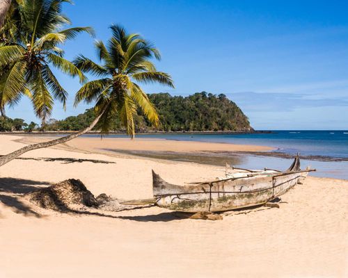
The west coast
With their palm-shaded sands and vivid sunsets over the Mozambique Channel, the west coast beaches of Nosy Be – a series of long bays bracketed by rocky headlands – are every inch the iconic image of a tropical paradise. Their warm, safe tidal lagoons are sheltered from the ocean by large sections of reef (which although degraded are still well worth diving or snorkelling) and the paved Route de l’Ouest that runs north to Andilana and then around the island passes just a few hundred metres from the shore, making access easy. And between the hotels and tourists, traditional village life carries on, with fishing boats pulled ashore and women pounding rice or preparing food on the porch.
Ambatoloaka
Just 10km from the capital, Ambatoloaka is the first resort area out of Hell-Ville, and also the busiest on the island. Yet this slip of a tourist town barely existed twenty years ago. It’s still charmingly low-key by international standards, consisting of a single 400-metre lane that runs just a block behind the beachfront and is lined with wooden shops, eating houses, hand-painted excursion and scooter-rental outlets and a couple of bar-discos. The close proximity of everything makes doing a restaurant or bar crawl supremely easy, and you’ll feel like you’re getting a genuine immersion in local life, though it’s a pretty tame scene. After dark, when the centre of Ambatoloaka is a car-free zone, it does become busier and livelier: you leave your vehicle at the town’s small, guarded car park at the north end of the road, and walk in past the barrier.
Past the rocky area at the north end of Ambatoloaka beach, the bay continues for a further kilometre or so as Madirokely beach. This is still fairly busy, the sands and sea not the most pristine, and the hawkers sometimes out in force, but Madirokely is a slightly more refined resort, with its own access road 1km further along the coast highway. A footpath leads between the two resort areas.
Ambondrona to Ampasy
The next beach north from Madirokely is Ambondrona. Again, it’s not the island’s best – the water can sometimes be cloudy here and you may feel a bit besieged by sales people – but the coast road passes right behind the beach and there are several hotels, including Domaine Manga Be. The next stretch takes in the less attractive resort areas of Belle-Vue and Ampasy.
Djamandjary
DJAMANDJARY is the island’s second town and has its own life aside from the tourist industry. As you drive north, on the right you’ll see the biggest Protestant church in Madagascar, built in 2012 by former president Marc Ravalomanana, a Protestant himself who noticed three times as many worshippers outside the former church as inside it. The concrete pill-box shaped houses on the left side of the road are the last standing cyclone-proof homes on the island – a French initiative during colonial times.
A little further north on the right side of the road you pass the SIRAMA sugar and rum factory, standing idle since 2006. There’s even an ancient locomotive sinking in rusty dereliction into the grass by the staff housing. Some 65 percent of Nosy Be’s lush, hilly countryside is held by SIRAMA, the state-owned sugar producer, which used to produce thousands of tons of sugar cane, mostly for the manufacture of rum. However production came to a halt in 2002 and since then much of the farmland has been carved into small, unofficial plots and planted with rice and other crops by islanders. If you want to have a go at hiking up to Mont Passot from here, note that the path, which can also be ascended on a trail bike, starts behind the factory.
Bemoko and around
Beyond the next headland is Bemoko beach – though there’s not much of it at high tide – and the area is less developed and more forested. It faces the hilly and partly forested island of Nosy Sakatia, which has a handful of places to stay of its own. You then pass a coastline of mangroves – and the uninhabited islet of Nosy Ratsy where stillborn infants were traditionally buried.
Andilana
Finally you reach the rocky headland of Andilana with its superb – though very much occupied – north-facing beaches. The sea around Andilana - with little surface drainage and close to the open ocean – tends to be very clear.
Mont Passot and the lakes
The lower of the island’s two peaks, Mont Passot (3298m) is a popular late afternoon trip to watch the sun go down over the Mozambique Channel, whether on foot or by car. En route you’ll pass several of the volcanic interior’s eleven crater lakes, all of which have populations of Nile crocodiles. Accidents with these big reptiles (the same species as in Africa, Crocodylus niloticus) are not uncommon, but this doesn’t seem to put local people off from fishing and using the lakes as a car wash – and in any case harming the animals is fady.
Lac Andjavibe, on the south side of the road as you approach by vehicle, is a black spot for crocodile deaths: on average somebody is taken from the shore every three to four years. Continue on and to the east side of the road is the first of two twin lakes, commonly known by the same name, the Lacs des Soeurs or Lacs Mirahavavy, but their true names are Antsimonigny (to the west) and Ambalavato (east). You go through a tollgate for Mont Passot (10,000ar) and there’s a short path to the rim of Lac Antanilatsaka, where a few women usually have some colourful craft stalls set out, selling beads, raffia toys, and embroidered fabrics. Close to the summit you pass Lac Bemapaza, directly by the roadside.
Passing big-leafed teak trees and a telecoms tower you come out on the summit to a 360-degree panorama. Before you is the island’s biggest lake and source of Hell-Ville’s drinking water, Lac Amparihibe and, almost connected to it, Lac Antsidihy, with Djamandjary further away on the coast. Looking south you can see the Lokobé rainforest and the islands of Nosy Komba and Nosy Tanikely. The summit has a new row of souvenir shops and an observation deck, but hopefully the shady mango tree will be preserved.
Réserve Naturelle Intégrale de Lokobé
The Réserve Naturelle Intégrale de Lokobé (Lokobé Strict Nature Reserve) is Nosy Be’s last area standing of pristine lowland rainforest. Considering how easy it is to walk up its eastern flanks, accessible on several footpaths, you’d be forgiven for not appreciating that on its western side, which rises vertiginously from the port at Hell-Ville to the highest point on the island (430m), this 7.4 square-kilometre rainforest is almost inaccessible.
Fauna and flora
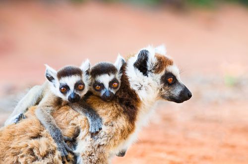
Lokobé is home to a diverse range of Malagasy fauna and flora, including a particularly fine range of palms, notably an extremely rare endemic species, Dypsis ampasindavae (kindro in Malagasy), of which only thirty trees exist, most of them here. You’re almost certain to see the dramatic-looking, whiskery-eared black lemur (Eulemur macaco) and the very cute Nosy Be sportive lemur (Lepilemur tymerlachsonorum) on a day walk. Sexually dimorphic black lemurs (only males are black; females are chestnut with white beards) are easily encountered as they forage for fruit through the low canopy, unintentionally dispersing seeds as they go. And sportive lemurs are easily spotted in their customary tree holes, staring curiously at camera-wielding visitors at a convenient height for photography. The minuscule, endemic Nosy Be mouse lemur (Microcebus mamiratra) is another matter: you need to go for an extended after-dark walk, take a good head torch, and listen for high-pitched squeaks.
In the cold-blooded line, you’ll be treated to the brilliant turquoise-green Nosy Be panther chameleon (Furcifer pardalis) and, if you’re lucky, the arboreal, skink-like, emerald-green zonosaurus lizard (Zonosaurus boettgeri; thought extinct but rediscovered here in the 1990s), as well as countless small species of frogs and geckos.
Approach
The commonest way to reach Lokobé is as part of an organized trip. You drive from Hell-Ville to the sandy, backwater village of Ambatozavavy. From here you take a heavy and solid lakana – a mangrove wood pirogue, with an outrigger made of very light ylang-ylang wood – and paddle around the southeast extremity of Nosy Be. About 1km along the coast, you’ll see among the rocks on the shore the flash of red and white cloth – Nosy Be’s sacred colours signifying areas of ritual importance (Ambatozavavy was named after the curious shape of female genitalia, or vavy, naturally incised here into a boulder by a fluke of geology). A short while later you reach the backwater beach village of Ampasipohy, meaning “Short Beach”. Periodically overrun by tour groups at weekends, it’s a quick walk from here into the magical forest.
Nosy's other Islands and Beaches
Offshore from Nosy Be lie several smaller islands, some with upmarket resorts offering a taste of barefoot (and exclusive) luxury, though idyllic Nosy Komba and Nosy Sakatia, famous for its orchids, make for straightforward day-trips from the mainland. Excursions to the former are often combined with the marine reserve of Nosy Tanikely, perfect for snorkelling.
Nosy Komba
The almost circular island of Nosy Komba, just 3km from the Lokobé peninsula, is a highly recommended day-trip from Hell-Ville. Peaking at 569m, this conical, partly forest-flanked island, has one main village, Ampangorina, on the north shore, and no roads. It is home to black lemurs (komba), traditionally protected by a fady and now the object of a flourishing village tourism industry, with habituated groups coming to feed on bananas and hop onto shoulders.
Nosy Tanikely Marine Reserve
Some 10km south of Hell-Ville, Nosy Tanikely is a pin-prick-sized, star-shaped marine reserve of forest-cloaked, black volcanic rock and pale sandy beaches, and, like Nosy Komba, is a high-profile excursion destination. Just 500m across, this is one of the best snorkelling sites in the area, its waters protected for a further 500m radius from the low-tide mark, and can get busy in high season. Big brown-marbled grouper fish (Epinehelus fuscoguttatus) come here to spawn in November and December, and there are black lemurs on the island and a good variety of other wildlife.
Nosy Sakatia
Pockmarked with ancient volcanic craters, and harbouring the most important turtle-nesting beaches in the Nosy Be region, Nosy Sakatia is Nosy Be’s second-biggest offshore island (4km long and 2km wide) and lies just off its northwest coast. There are several small villages, but no roads: you move around Sakatia by boat, or hike through the bush on well-worn paths.
Nosy Iranja
Another important turtle nesting site, Nosy Iranja is really two islands, joined by a sandy spit (exposed at low tide), off the west coast of the Ampasindava peninsula across the bay from Nosy Be. The large resort hotel occupying most of Iranja Kely, the smaller, southern island, has been abandoned under a cloud, leaving a visit here to adventurous travellers, who camp on the beach, or to people booked to stay at Zahir Nosy Iranja, the small establishment on the north island, near the village.
Nosy Mitsio and Nosy Tsarabanjina
The volcanic archipelago of Nosy Mitsio, around 70km northeast of Nosy Be, consists of the main island of Mitsio, a 40-square kilometre, dragon-shaped outcrop of beach-fringed bush and patchy cultivation, and a clutch of uninhabited satellite islets, one of which – tiny Nosy Tsarabanjina – is dominated by Constance Lodge. This whole area of shallow seas is excellent for diving and snorkelling.
Parc National de la Montagne d’Ambre
The delightfully named Parc National de la Montagne d’Ambre (Amber Mountain National Park), which protects a huge, extinct shield volcano that last blew its top around two million years ago and now peaks at 1474m, is one of Madagascar’s oldest and finest natural areas. Created in 1958, it is loved and venerated by local people as much as by passing visitors, and its crater lakes, waterfalls and dark rainforests teem with life (many species remain to be discovered) and combine to make a strong impression.
The higher slopes of the mountain receive around 3500mm of annual rainfall, similar to parts of eastern Madagascar; most of this falls between December and March, though no months are really dry. Around the Station des Roussettes, a clearing in the forest that forms the main human focus in the park, it rains much less often between May and October, but the park averages 6–10°C cooler than Diego, so although it’s humid you’ll need some warm layers, especially in July and August. Harmless leeches tend to be a problem in the wetter areas and during heavy rains. Mosquitoes can strike at any time: be prepared.
Unfortunately, there were two armed robberies in the park in late 2013 – incidents that received international attention and briefly became the subject of travel warnings. They seem to be have been isolated cases, however, and at the time of writing, the local view was that a repeat episode was unlikely.
Route de Montagne d’Ambre
The Route de Montagne d’Ambre, off the main RN6, is a narrow road built by the French, overhung by foliage and climbing slowly through hills and farmland. It soon becomes very potholed, allowing for careful inspection of the nearby bushes (regularly bejewelled by colourful day geckos and poised chameleons) as your vehicle crawls past. Climbing the mountain you pass through abrupt changes of scenery, from dry grasslands and farms to permanently moist rainforest, over the space of just a few kilometres. The dense vegetation around Joffreville, the park’s main town, signals your imminent arrival. The tarmac ends here and only good 4x4s can make the final 3.5km along the (usually) wet-earth and rock track up to the park entrance: in the wet season, without your own vehicle, you’ll almost certainly have to walk this last stretch.
Joffreville
There’s little substance to the straggling ex-colonial hill station of JOFFREVILLE, founded in 1903 at the village of Ambohitra, though there are a few crumbling old ruins from the days of the colons flanking its broad, cobbled, two-lane avenue. These include a single general store and, near the top, a hideous abandoned tower block that turns out to be a former “École Normale”.
Park trails
While the forest footpaths are often slippery, some of the motor trails are in good condition, and this is one of the most vehicle-accessible of Madagascar’s parks. There’s an easy circuit of (mixed-use) driving and walking trails looping around the Station des Roussettes (roussette: fruit bat), taking in a lake and three waterfalls (cascades), making a park visit of anything from a few hours to a full day straightforward and very rewarding.
Ten minutes’ walk from the forest station is the Lac Sacrée, a deep crater pool with a viewpoint looking across to a tumbling waterfall, where local people traditionally leave offerings to the spirits of the ancestors they believe are now confined to these remaining forests. A short walk to the north, following the stream valley, brings you to the Cascade Antankarana – a fine veil of water over a fern-draped rocky hollow. If you have all day, you can follow the Voie des Milles Arbres (“Thousand Tree Way”), and the Circuit Grand Cascade, and you’ll eventually reach the Cascade d’Antomoboka.
A two-hour round-trip walk from the forest station will take you to Lac Mahasarika or Petit Lac. Four more lakes lie higher up through the forest to the south, but the terrain is much steeper and heading up here is only possible if you’re fully equipped to camp out. The second lake, Lac Grande, is a half-day hike for most people (assuming you’re stopping frequently along the way) and marks the start of the climb to the main caldera at the mountain’s peak, less than 1km to the west.
Flora
An arboretum as much as a conventional national park, Montagne d’Ambre features many named trees along its paths, and a good number of them – such as Japanese cedars, Brazilian araucarias and water-sucking gum trees from Australia – are foreign exotics planted in the colonial period in agro-forestry trials. The botanical highlights, however, are the indigenous tree ferns, lianas and Dracaenadragon plants growing among the rosewoods and specimens of Canaria madagascariensis – the tree whose aromatic resin gives the park the amber for which it’s famous.
Wildlife
The Amber Mountain is a reptile paradise: you can see half a dozen species of chameleons alone in your first hour in the park, including the wonderful nez-bleu (the blue-nosed Calumma boettgeri), the splendid panther chameleon (Furcifer pardalis) and no fewer than four species of tiny ground-dwelling Brookesia that live only on this mountain.
Mammals
The mountain’s diurnal lemurs include crowned lemurs (Eulemur coronatus), with their neat grey coats and orange head markings, and Sanford’s brown lemurs (Eulemur sanfordi), which have grey faces and males with rather untidy white beards and ear tufts. Both species have some relatively habituated troops, and there’s something slightly unnerving and child-like about the way the stocky Sanford’s lemurs clamber through the branches and watch passers-by. The mountain has seven nocturnal lemurs, including the noisy and very mobile Montagne d’Ambre fork-marked lemur (Phaner electromontis), and is also rated highly as a spot to see some of Madagascar’s native carnivores, though the worm-eating falanouc and ring-tailed mongoose can prove almost as elusive as the aye-aye – you might be lucky if you sit out quietly at dawn or dusk around the campsite in the park. Since there seems little prospect of night walks being allowed in the near future, these animals have the forest to themselves – for more chance of spotting them visit the private reserve at the Domaine de Fontenay, where you can walk whenever you like.
Birds and insects
The park’s bird count numbers more than seventy species, including the exceptionally rare and vociferous Madagascar fish eagle (Haliaeetus vociferoides) and the beautiful Madagascar crested ibis (Lophotibis cristata). But the avian star is the Amber Mountain rock thrush (Monticola erythronotus), endemic to this forest: the male, with his blue head, has a beautiful song.
Aside from the insects you would prefer to avoid, the park is home to some impressive swallowtail butterflies, easily seen as they break through shafts of sunlight, but hard to photograph in their ceaseless flight.
Parc National d’Ankarana
Limestone karst landscapes are not unique to Madagascar but the island’s extreme version – the spectacular pinnacle rocks known as tsingy – is so harsh, alien and inaccessible that it might as well be from another planet. The Parc National d’Ankarana, a tsingy landscape 30km long and 8km across, is the easiest place to experience this geological phenomenon: the RN6 highway passes just a couple of kilometres from the outliers of these expanses of needle-like rocky shards. Visiting the reserve is a fascinating experience, and very worthwhile, whether you have a few hours or several days.
The main park gate is located at the tiny hamlet of Mahamasina. The park can be visited all year round from the east side, but flooded tracks during the rains mean its hard-to-reach western entrance doesn’t normally open until July. It can be very humid and mosquitoes and biting flies are often a nuisance – take plenty of repellent.
Hikes in the park
The national park is around 25 percent shady forest and 75 percent rugged limestone pinnacles, though which very rough footpaths have been built, linked together with occasional stretches of wooden steps and footpath suspension bridges.
Short walks through the forest and up onto the two tsingy formations nearest to Mahamasina – the tsingy meva or “small tsingy” and the tsingy rary or “braided tsingy” (a reference to its stripy appearance) – are great fun, but some of Ankarana’s glories lie beneath the surface, in the subterranean cave and river systems. You can sense this as you stomp around, as your footsteps often sound hollow. Walking on the forest paths is relatively easy, but climbing up into the tsingy – which involves some scrambling and squeezing through gaps in the rocks, as well as some steep ascents – is much tougher. It will also destroy your shoes if they’re not suitable: you need good hiking boots or well-built trainers. To visit the caves you’ll need to camp out and devote several days, but they’re highly recommended.
Flora
Ankarana is a botanist’s delight, with more than 330 species of plants recorded so far. Ribbons of dense forest fill the sunken canyons between the major tsingy formations, and plants and trees continue to colonize the tsingy themselves, so while the pinnacles are all but impenetrable to humans except on walkways and bridges, Ankarana’s lemurs and other wildlife can happily feed and take refuge among them.
There’s a striking difference between the deciduous trees growing directly out of the tsingy, which lose their leaves in the middle of the dry season and burst into life again after the rains in December, and the trees in the forest-filled canyons between the limestone outcrops, which are evergreen or constantly regrowing and much more jungle-like.
Lianas (lianes in French) are common here, sprouting from any pocket of nutrient and searching triffid-like for purchase on a tsingy pinnacle or up into the branches of a more conventional tree, before sending their tendrils back down to the ground. Ask your guide to show you the liane-pête (péter is the French for “fart”), whose leaves, when squashed, smell strongly sulphurous. Malagasy school kids play tricks on each other with them, but they’re said to be good for your teeth and stomach.
Ankarana has at least four species of baobabs (Madagascar has seven of the world’s nine) and is one of the best places in Madagascar to see the bizarre, rock-like succulent Adenia neohumbertii. Other notable trees include the spine-covered tsagnaniamposa, meaning the tree that can’t be climbed by the posa (the phonetic spelling of Madagascar’s secretive large carnivore, the fossa).
Wildlife
While you almost certainly won’t see a fossa, these nocturnal predators are around, preying on the very high density of crowned and Sanford’s lemurs (Eulemur coronatus and E. sanfordi). These two species of lemur are found in the canyon forests at densities of up to 500 per square kilometre, making Ankarana one of the most densely populated primate habitats in the world. The local Antankarana people have a fady on killing all lemurs apart from the aye-aye, and the crowned and Sanford’s lemurs are naturally quite habituated here. Crowned lemurs need to eat huge quantities of leaves to obtain enough nourishment, and they defecate almost constantly to make room for more – as you’ll soon discover if you start taking photos from beneath a troop of them.
As for the caves, there are more species of bats here than anywhere else in Madagascar as well as various signs of early human habitation and some big crocs in Crocodile Cave. Look out for the handsome brown and green mottled frog, Tsingymantis antitra, only recently discovered, which has no close relatives and only lives in Ankarana.
The formation of the tsingy
Ankarana’s limestone massif formed on the ocean bed during the age of the dinosaurs, rose, then cracked, resulting in the steep scarp on the west and the gentler slopes to the east. This tectonic movement created and then sank a huge network of caves. Over the millennia, the range cracked further, from east to west, breaking open the cave systems and creating channels for several rivers. Mildly acidic rainwater dissolved into the softer strata of limestone from above, and carved it out from underneath, eroding the solid rock both vertically and horizontally, and wearing it away on every surface to a sponge-like, porous honeycomb of limestone cells. It’s also believed that the snails whose shells you see everywhere may have contributed over the aeons to the process of erosion, by rasping the limestone surface for algae growing in rain puddles in the rock.
Top image © Christian Nilsen/Shutterstock