Northeastern Madagascar Travel Guide

The rainforests of northeastern Madagascar are some of the most biodiverse areas on the planet. Deluged in parts by as much as 6000mm of rain in the course of a year, these hilly landscapes support a riotous display of jungle trees, lianas and other flora, and extraordinarily rich wildlife, from minuscule chameleons to weighty indri lemurs. In the wettest areas, the air is almost always damp, while steep and slippery trails can make access to some parks challenging. The region gets rainfall throughout the year, but the driest time to visit is mid-September to late November. In higher areas, the nights can be cool during July and August.

While the northeast’s natural vegetation is dense forest, the vast majority of trees had been cut by the time of independence, and today rice and sugar-cane fields, and plantations of vanilla and fruit trees, account for much of the more level ground. The sizeable pockets of forest that remain are major strongholds of Madagascar’s natural heritage, now flagged by UNESCO as the “Rainforests of the Atsinanana” group of World Heritage Sites in Danger.

Just a three-hour drive east of Antananarivo, one of the country’s most accessible and rewarding parks is Parc National d’Andasibe-Mantadia, which has a less extreme rainfall pattern than much of the region and some relatively easy trails. Four hours’ drive further east is Tamatave (less commonly known as Toamasina), a major Indian Ocean port and springboard for the remote far northeast. The idyllic Île Sainte Marie, with its outstanding beaches and diving and snorkelling opportunities, is reasonably accessible from here.

Back on the mainland, if you plunge on northwards the rewards mount along with the difficulty of travel (most visitors fly), as the tough and unpredictable coastal road, the RN5, takes you to the privately owned Aye-Aye Island near Mananara and eventually the remote town of Maroantsetra. From here you can reach the fabled island of Nosy Mangabe and the cloud-shrouded flanks of the Parc National de Masoala, home of Madagascar’s most stunning rainforests.

Beyond the Masoala peninsula lies Madagascar’s prime vanilla-exporting region of Sava, named after its four main towns, Sambava, Antalaha, Vohemar and Andapa. The last of these is the highland base for the rugged Parc National de Marojejy and Réserve Spéciale de Anjanaharibe-Sud.

Moramanga

After a series of step-like ridges on the winding descent from Antananarivo, you’ll reach the small town of MORAMANGA (“cheap mangoes”), which is the capital of the Bezanozano people, who live between the Betsimisaraka on the coast and the highland Merina. The closest transport hub and supply base for the Parc National d’Andasibe-Mantadia, the town is famous as the starting point of the insurrection against the French on March 29, 1947, when militants stormed a police camp with spears. A reprisal massacre of political activists left more than 100 dead. There’s a monument near the railway station commemorating their deaths, a mausoleum on the outskirts of town and a newly refurbished Police Museum at Tristani Police Camp, which is still mostly a collection of old weapons and odds and ends.

Parc National d’Andasibe-Mantadia and around

If the Parc National d’Andasibe-Mantadia is your first encounter with wild lemurs, as it is for many visitors, it is hard to prepare for the grace, proximity and sheer variety of these remarkable primates. The otherworldly chorus of a family of indris (Indri indri, babakoto in Malagasy) – the most famous of the park’s denizens – reverberating through the misty, early morning forest, is an unforgettable sound.

Andasibe National Park comprises a group of small, mid-altitude forest tracts. Two hundred species of orchids bloom magnificently here (from December to March) and the forests are home to six species of diurnal and six nocturnal lemurs, some 110 species of birds, more than seventy species of reptiles and at least a hundred species of frogs – a figure that makes this the most frog-rich area on earth. In addition, there are thousands of species of insects and other invertebrates, from huge silkmoths to weird giraffe-necked weevils.

The parks have easy access and a good range of places to stay – one of which, Vakôna Forest Lodge, has a small private lemur reserve of its own. Of the protected areas, only one, the Station Forestière Analamazaotra, allows night walks, but you can also do nocturnal wildlife viewing in the trees along the quiet tarmac road between the RN2 and Andasibe village, a stretch that can yield very good sightings, including of mouse lemurs and boas.

Réserve Spéciale d’Analamazaotra

When people talk about Andasibe, it is the 8-square-kilometre patch of mixed primary and secondary forest that makes up Réserve Spéciale d’Analamazaotra that they’re usually referring to. Ranging in altitude from 900m to 1250m, Analamazaotra is your first port of call to see and, hopefully, hear one of the several groups of indris that range across the forest.

Trails

Starting from the visitor centre, the main trail passes a set of former fishponds that were swamped by a cyclone and never rebuilt, then splits into several trails that climb into the forest: Circuit Indri 1, which passes through the territory of habituated indris and other lemurs around the sickle-shaped Lac Vert or Green Lake (2km, 2hr); Circuit Indri 2, which continues past Circuit Indri 1 and includes more primary forest with big trees (3.5km, 4hr); Circuit Anivokely, with steeper trails and denser vegetation (2km, 2hr); and Circuit Aventure, which includes trails 1 and 2 and also visits wilder areas (6km, 6hr).

Wildlife

For the best chance of having time on your own with a group of indri, get here as early as possible: the paths can get busy with groups of visitors by 8.30am, especially in high season, and indris feed early, usually settling down for a siesta during the middle hours of the day. You may well hear their wailing, done to mark territories, before seeing the family, though they call much less frequently in the cooler season from July to September. The indri is an unmistakeable lemur, resembling a black and white teddy bear with Mickey Mouse ears and piercing green eyes. While feeding, they can sit or lounge without moving for long periods, but despite having only a stump of a tail (this is the only tailless lemur) they bound very rapidly through the trees when they decide to move, using their long, powerful hind legs to catapult from trunk to trunk, arms outstretched.

As well as indris, you will commonly see diademed sifakas (Propithecus diadema diadema), translocated in 2007 from the forests around the huge Ambatovy nickel and cobalt mine north of Moramanga. Some of them wear radio collars. Almost as bulky as indris, but with long tails, these handsome lemurs (called simpona in Malagasy) have a colour scheme of white, black, silver, gold and chestnut, with black feet, hands and faces, and are content to feed, groom and socialize just a few metres above your head. The reserve’s grey bamboo lemurs (Hapalemur griseus griseus) and brown lemurs (Eulemur fulvus) are both easily seen, but are shyer.

Likely bird sightings in the Andasibe parks area include the red-breasted coua, the blue coua and the Madagascar crested ibis. Chameleons, especially the big Parson’s chameleon (Calumma parsonii), and the diminutive horned pygmy (Brookesia superciliaris) and Thiel’s pygmy (Brookesia thieli) chameleons that move through the leaf litter on the forest floor, are relatively common, but collection for the exotic pet trade has seriously depleted their numbers.

Station Forestière Analamazaotra

The local NGO Association Mitsinjo (the name means “Look ahead to care for the future”) has its offices on the west side of the tarmac road, just 150m south of the Analamazaotra visitor centre. With support from the Finnish Association for Nature Conservation, they run reforestation programmes (they’ve planted more than 250,000 native saplings), and manage the 2.5-square-kilometre Station Forestière Analamazaotra which, as well as harbouring the same species as the Réserve Spéciale, offers very rewarding night walks. After dark, expect to see Goodman’s mouse lemurs (Microcebus lehilahytsara), tenrecs (endemic mammals resembling hedgehogs and shrews), various snakes, sleeping chameleons, numerous insects and countless species of frogs. There are some easy main trails, but the smaller paths are harder going. A good torch is essential.

Parc National Mantadia

Parc National Mantadia, a 98-square-kilometre tract of mostly primary forest north of Andasibe village, has the same altitude range as the Réserve Spéciale d’Analamazaotra but is much less visited, and has only limited and much more challenging trails, making sightings more exciting as a result. Lively and inquisitive southern black-and-white ruffed lemurs, or vary in Malagasy (Varecia variegata editorum), are a key species here: they’re sometimes seen near the road around PK15, where a forested hill rises to the west.

Four park trails pitch up the east–west ridges: the Circuit Rianasoa (1.5km, 2hr) ends by a natural swimming hole beneath a waterfall; Circuit de la Chute Sacrée (2km, 2hr) takes in ritual sites of the Bezanozano people; Circuit Belakato (3.5km, 3hr) is a fairly tough hike but gives the best lemur-viewing chances; and the so-called Circuit Trekking (10km, all day) is a demanding route that combines the higher reaches of the other three trails.

If you’re birding – and lucky – the very rare Madagascar serpent eagle (Eutriorchis astur) and strikingly blue-billed helmet vanga (Euryceros prevosti) can both be seen in Mantadia, as can the various species of pretty ground rollers: you’re much less likely to see any of these in Analamazaotra.

Brickaville to Tamatave

From the Andasibe turning, the often steep road winds down to the coastal plain at Antsampanana, where it splits south to follow the Canal des Pangalanes and beyond, and north to BRICKAVILLE. During the political crisis of 2002, the major bridge across the Rianila River here was cut by Ratsiraka’s supporters when they fled to Tamatave, and in May 2003 Cyclone Manou damaged many of Brickaville’s buildings. It remains a busy centre, however, surrounded by orange groves and sugar fields.

Down at sea level, a very pretty stretch of road runs north towards Tamatave, alongside a tributary of the Rianila, the Rongaronga, with lofty groves of bamboo overhanging the road. Closer to Tamatave, you pass major oil palm plantations.

North to Maroantsetra

The RN5 north out of Tamatave starts off surfaced and in reasonable condition, fringed by magnificent beaches, passing the Parc Ivoloina and then the old settlements of Foulepointe and Fénérive Est. The 240km coastal section between Soanierana-Ivongo and Maroantsetra, however, is one of the toughest roads in the country – a barely drivable earth and rock track that deteriorates in condition as you crawl north, as does the viability of the twelve ad hoc river crossings that have to be negotiated along the way. The worst stretches and the dodgiest makeshift ferries (some of them simple bamboo rafts) tend to vary from year to year depending on the damage inflicted by the most recent cyclones. The 50km stretch between Antanambe and Mananara is usually considered the hardest, and often takes a full day, most of that at walking speed.

Soanierana-Ivongo

SOANIERANA-IVONGO, where the tarmac ends on the way north, like so many of Madagascar’s coastal towns occupies a spit of land between the ocean and the mouth of a river – in this case the River Marimbona, which starts life high up on the Marovoalavo plateau on Madagascar’s spine. The little town’s port is along the riverside, and the small ferries plying the 30km sea channel to Île Sainte Marie have to brave the rough seas between the river mouth and the ocean. There are few facilities in town, but you’ll find basic accommodation and restaurants if you need them.

Parc National de Mananara Nord and around

The author and naturalist Gerald Durrell put the town of MANANARA on the map in 1992 in The Aye-Aye and I, his account of capturing two male and four female aye-ayes for a breeding programme at Jersey zoo.

The Parc National de Mananara Nord is aye-aye country, but you need to stop at Antanambe (where one of the park offices is located) and hike far into the hills, or take a taxi brousse from Mananara to Sandrakatsy, and then hike for several hours, to find good aye-aye habitat in more or less undisturbed rainforest. Offshore lies the marine parcel of the park, with superb coral around the islet of Nosy Hely.

Aye-Aye Island

For the best chance – though as ever no absolute guarantee – of seeing wild aye-ayes, stop in Mananara town for a day or two, stay at Chez Roger, and spend an evening visiting Île Mon Désir, or Aye-Aye Island, a 30-hectare island in the Mananara River, just 5km upstream from the town centre, that was formerly a plantation but is now covered in secondary forest. It belongs to Roger, the owner of the hotel, who introduced aye-ayes here in the 1990s. They continue to thrive and breed.

The Aye-aye

Gerald Durrell, The Aye-aye and I

It was Lewis Carroll’s Jabberwocky come to life, whiffling through its tulgey wood

First described at the end of the eighteenth century, but only recognized as a primate a century later, the aye-aye (Daubentonia madagascariensis) is one of the world’s most bizarre and distinctive mammals. This cat-sized beast is the largest nocturnal lemur – but with its enormous mobile radar-like ears, coarse fur, long bushy tail, clawed hands and feet, and unnervingly huge, continuously growing incisors, it was long thought to be a kind of large squirrel. How the aye-aye (the origin of the name is unknown, but it’s rendered haye-haye in Malagasy) relates to other lemurs is still the subject of great conjecture among zoologists: current thinking places it quite apart from all other lemurs, though it’s presumed to share a common ancestor.

Constantly on the move after dark, aye-ayes forage through the trees and on the ground for hundreds of metres every night. Partly filling the natural niche occupied by woodpeckers in most parts of the world, they locate insect larvae by tapping and listening, then – using their disturbingly thin, flexible third finger – hook grubs from the holes they gnaw in branches and tree trunks. The aye-aye isn’t strictly an insectivore, however: the same finger is used as a spoon to scoop the juice and flesh from coconuts (the aye-aye having first sliced into them with those sharp teeth), to scrape nectar from flowers, and to pick its teeth. Ramy nuts (Canarium madagascariense), tree bark, fungi, birds’ eggs, and (where available) sugar cane, lychees and mangos all form part of its omnivorous diet.

Persecuted for damaging crops, and also because of the widespread belief that they portend evil – in many areas local fady tradition holds that they should be killed on sight, and their corpses strung up in places where strangers will see them and thus carry away the bad luck – the aye-aye was thought to be extinct in the 1930s, and was only rediscovered in 1957. Ironically, they’re now known to be the most widespread of all lemurs, living in most of the forested parts of Madagascar. Being widespread, however, does not make for a secure future, and the aye-aye’s low population density makes it susceptible to ongoing environmental destruction. So, too, do its unusual breeding habits: the smaller males gather to fight over mating rights (if there are too few males they may not be sufficiently stimulated to tackle the female, who is herself only receptive for a short time once a year), and the successful suitor then remains locked onto his mate for up to an hour. Females give birth to a single, helpless infant every two to three years. It’s a precarious procreation process for one of the world’s most vulnerable and least understood higher mammals. Only through captive breeding programmes – increasingly successful – does the aye-aye’s future look anything but dicey.

Maroantsetra

Almost cut off from the rest of Madagascar, with forested hills rising sheer in the distance, the back-of-beyond town of MAROANTSETRA seems a suitable introduction to the wild and wet Masoala region, which protects the Baie d’Antongil from the rough seas of the Indian Ocean. The town’s rainfall averages around 4000m, with downpours almost every day of the year.

Spanning the delta of the Antainambalana River, this friendly settlement of sandy streets and wooden houses sprawls northwards from its beach on the Baie d’Antongil into a hinterland of rice paddies and bush near the airport. Most of Maroantsetra’s simple hotels, eating houses, shops and offices line the one main street, which leads from the airport into town. A crisscross of sandy lanes to the east of town runs out to the riverbank which serves as a cargo port.

There are no compelling reasons to stay long in Maroantsetra: the beach is a shadeless, working fishing strand rather than a place to relax, and most of your time in town is likely to be spent organizing a visit to Nosy Mangabe and Masoala. While you’re here, look out for some of the herpetofauna of the region, including brilliant scarlet tomato frogs (Dyscophus antongilii), easily found in the puddles and streams around the town’s vegetable gardens, and panther chameleons (Furcifer pardalis), the males of which are spectacularly emblazoned in ginger, green and ice-blue.

Réserve Spéciale de Nosy Mangabe

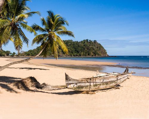
It’s hard to imagine an isle that could better bring to life the Treasure Island of legend than Nosy Mangabe. As you approach it from Maroantsetra, its steep flanks, festooned with rainforest trees from sea to summit, look all but impenetrable; low clouds drift through the dense canopy of forest giants and flocks of white egrets crowd their branches.

The island, thought to be one of the earliest human settlements in Madagascar, was colonized some 1200 years ago, and has a long history as a secure bolthole in a region of rough seas – though it no longer has any permanent inhabitants. European slave traders and pirates made it a base in the seventeenth and eighteenth centuries and most of its trees were felled for fuel and boat-building. Later the forest recovered and the island is once again thickly covered in lowland rainforest. Cultural artefacts remain here, in the shape of Betsimisaraka tombs and seventeenth-century Dutch rock engravings.

Wildlife

Just five square kilometres in extent, rising steeply to a summit of 264m, Nosy Mangabe’s big draw is its remarkable forest and wildlife. On such a small island, so magnificently endowed with natural riches, every step you take is a delight. It’s an easy stroll along the main path through the woods behind the beach, which is broad and level, and the best one to explore if you’re short on time. Walking here can be very slow progress, as you stop every couple of metres to look at something on either side or overhead.

Lemurs

The island is home to five species of lemurs. Three of these are nocturnal: a still unidentified mouse lemur, the greater dwarf lemur (Cheirogaleus major) and – notoriously – the aye-aye. Aye-ayes were brought from the mainland to Nosy Mangabe in 1966 when they were thought to be on the verge of extinction. They flourished here and were seen quite often for several decades. Since the turn of the century, however, sightings have been very rare, and with night walks forbidden (after two visitors made off with suitcases loaded with fauna), your only opportunity will be a highly unlikely sighting by day or a chance encounter at dawn. You will see their untidy nests though, and large of flakes of bark at the base of afzelia trees: Nosy Mangabe is the only area where aye-ayes are known to eat bark.

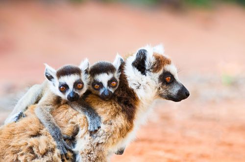
While you probably won’t see an aye-aye, both species of diurnal lemurs are likely to visit you around the visitor centre: the male white-fronted brown (Eulemur albifrons) is noticeable for his white beard, cheeks and crown; the plain brown female looks like a different species. The rare local variety of the black-and-white ruffed lemur (Varecia variegata subcincta) is unmistakeable and particularly inquisitive. Nosy Mangabe is one of their last secure habitats.

Lizards and insects

On walks through the woods, your guide will be eager to find you a leaf-tailed gecko (Uroplatus fimbriatus), an extraordinarily well-camouflaged lizard whose markings and scaly flaps blend perfectly with tree bark. If you’ve done your homework you may see the adult geckos independently of your guide: resting on trees alongside the path and measuring up to about 25cm in length, they spend the daylight hours asleep, head downwards, clinging tightly to small tree trunks. Even when spotted, they tend not to flee, but rear up, open their mouths threateningly, wag their tails and issue a high-pitched squeal. One explanation for why these lizards are so common is the strange absence of couas from the island’s bird list; blue couas in particular are very partial to soft, hatchling geckos.

Other lizards to look out for are the emerald-green, skink-like arboreal Zonosaurus boettgeri and its humbler forest-floor-based cousin Z. madagascariensis. Also down in the leaf litter you’ll find tiny Brookesiachameleons: B.superciliaris, with its comically raised “eyebrows” is aptly named. In the bushes, look out for bigger chameleons too, and for some huge caterpillars: one species, bright red, with large “eyes” on its side seems bent on convincing predators it’s another predator.

Nosy Mangabe’s historical sites

Nosy Mangabe’s only landing beach is on the west shore, where a glorious 500-metre crescent of sand is backed by a fringe of gently sloping forest, fishermen’s huts at the southern end, and the national parks office and some basic visitor facilities at the northern end. The walk behind the beach continues past the visitor centre to a picturesque bridge over a stream and a waterfall where you can swim, and then continues north to the Dutch engravings at the Plage des Hollandais (around 7km) – a crop of names carved into giant rocks on the sand, also easily reach by sea. The inscriptions date from between 1601 and 1657 and archeologists have established that, far being a collection of “Thomas was here” graffiti, they are the remnants of an informal postal service, whose carvers used this spot to leave letters, wrapped in tar cloth envelopes, to be picked up by ships passing in the opposite direction.

As you head inland, a steep circular trail leads up to the summit of the island and back again to the fishing huts (about 6km) via some old Betsimisaraka tombs and the lighthouse. There’s a map at the visitor centre covered with alluring pictograms of the animals you’ll see en route.

Parc National de Masoala

You might want to make the Parc National de Masoala one of your main goals in Madagascar: there is nowhere else like it in the country, or indeed perhaps on earth. Along its western side, the park is dominated by steep, north–south mountain ridges, and in places the rainforest rises almost straight up from the shore to misty heights more than 1000m above sea level in the space of a few kilometres. The park’s western districts have the highest rainfall in Madagascar, recording an average of 6000m, or more than six times the UK’s rainfall.

Masoala National Park was founded in 1997 with close support from the New York-based Wildlife Conservation Society and Zurich Zoo, and at 2400 square kilometres is Madagascar’s biggest and most remote protected area, covering much of the Masoala peninsula. Heavily encroached by illegal logging, it still contains vast swathes of primary rainforest tumbling down the steep hillsides and right over golden beaches along the shore of the Baie d’Antongil. There’s a dazzling super-abundance of flora and fauna here, including more than a hundred species of palms, 76 frogs, 72 reptiles, 85 birds and ten species of lemur.

March, April and August are the wettest months and September to November the least rainy. The best time to visit Masoala is roughly from the end of August to December, ideally October or November. It still rains frequently during these months but the dry spells are much longer and the sea calmer. Access is difficult and needs some planning and flexibility: only one road even comes close to the park, and most visitors arrive by boat from Maroantsetra, either independently, or having booked one of the lodges that provide boat transfers. The rewards are a true sense of adventure and exploration in an exceptionally beautiful environment, with almost limitless opportunities to see some of the world’s most outstanding animals and plants in their natural habitat.

Along the coast

Most people arrive by boat along the beach near the tiny hamlet of Ambodiforaha, where there’s a cluster of tourist lodges stretching for a few kilometres along the shore. From behind the lodges, there are several routes into the park, including the Circuit Varignena, which starts at an almost imperceptible break in the wall of jungle just past the northernmost lodge, the Petit Relais de Masoala. It’s also a fine 3km walk along the coast from the Petit Relais to Tampolo Point. At low tide you can walk much of the way on the beach itself, where natural beachcombings (no oil or plastic bottles here), ranging from contorted bamboo roots to delicate flower blooms, add to the pleasure, though there’s also a trail through the forest just a few steps above the high-tide mark which provides welcome shade when it’s sunny. Along the way there are several streams, some easily fordable, others requiring use of the community-operated pirogue-ferries that stand by to carry passengers from dawn to dusk (no charge).

South of Tampolo Point, a 7km string of beaches borders the Tampolo Marine Park, a superb area to snorkel, but only accessible by chartering a boat for the day from one of the lodges.

Hiking in the interior

The only access to the interior of the Masoala rainforest is on foot, and this is hard-core hiking county: the paths up through the forest are often steep and narrow, covered in mossy boulders and slippery roots. There are rushing, picture-postcard streams to cross, decked with dripping foliage. The atmosphere is so humid that, despite temperatures in the high 20s, your breath mists in front of your face and steams up spectacles and camera lenses. It’s exactly like being in a tropical butterfly house. Water drips constantly from the foliage above, and every few hours there’s another downpour, interrupting the sun’s efforts to illuminate the understorey – and making photography, in the half light, very challenging. Biting flies (though happily few mosquitoes or leeches) add to the ambience. All the while, however, your discomfort is allayed by the continual distraction of a multitude of life forms, from leaping lemurs to birds in the undergrowth, frogs in tree ferns, chameleons and snakes in the vines overhead and a profusion of insects and other invertebrates all around you.

Flora

The forest giants whose buttress-roots you scramble over include 30m Canarium trees (ramy in Malagasy, the traditional source of timber for dug-out canoes) and endangered Dalbergia rosewoods (D. maritima and D. baronii), while the lower storeys of the forest are a complex ecosystem, with more than a hundred species of palm and 155 types of fern, as well as many orchids and other epiphytes and climbing lianas. A new species of locally endemic carnivorous pitcher plant – the dangerous-looking Nepenthes masoalensis – was recently discovered here, and hitherto unknown plants and animals from Masoala are described every year.

Wildlife

Larger animals to look out for include: the easily seen and very distinctive red ruffed lemur (Varecia rubra), a very vocal fruit-eating lemur which is endemic to the Masoala peninsula; the white-fronted brown lemur (Eulemur albifrons); and the very rare brown-tailed mongoose (Salanoia concolor), a fluffy-tailed diurnal hunter of the forest floor. Walking after dark, you may well see the eyes of a Masoala fork-marked lemur (Phaner furcifer) or, if you’re very lucky, the locally endemic Masoala woolly lemur (Avahi mooreorum) or Masoala sportive lemur (Lepilemur scottorum), both of which were discovered as recently as 2008. More than a dozen species of bats take to the night skies, including the huge Madagascar flying fox (Pteropus rufus) – often seen before sunset, flying off to feeding areas.

Birds of Masoala include the highly endangered Madagascar serpent eagle (Eutriorchis astur) and the rarely seen Bernier’s vanga (Oriolia bernieri), helmet vanga (Euryceros prevostii) and scaly ground roller (Geobiastes squamigerus).

As many as half of Madagascar’s estimated 400 species of frogs are thought to live only in Masoala, many of them completely unstudied, so that next to nothing is known about their breeding habits. Stand by any stream for a minute or two and you’re likely to spot several attractive species – hopping over your boot, gulping on a rock or on a shiny leaf, or kicking through the water.

Insects are legion, but the lepidoptera stand out: of more than 130 species of butterflies and moths, Masoala has at least five known only from the peninsula. The stunningly coloured, fast-flying sunset moth (Chrysiridia rhipheus) can often be seen flitting through the tree blossoms over Ambodiforaha beach.

Sava – the Vanilla Coast

The relatively wealthy far northeast coast is Madagascar’s prime region for the cultivation and export of vanilla, local prosperity being tied umbilically to the fortunes of the flavoursome pods on world markets. In the early years of this century this Sava region (named after the initials of its main towns) experienced an unprecedented economic boom as vanilla prices rose steeply – roads and airports were built and thousands of migrants moved here – and then a crash as vanilla prices plummeted. This coast is also notoriously prone to cyclones: in March 2004 it was devastated by Cyclone Gafilo, the most intense cyclone ever recorded in the southwest Indian Ocean, and a string of slightly less devastating storms mangled the region in 2007.

Today, Sava remains a relatively well-off area, with the surfaced road between Antalaha and Vohemar one of the best in the country, though the scruffy signs of bust-after-boom, cyclone damage and subsequent repair are everywhere. Inland, in the mountains west of Sambava, are the remote parks of Marojejy and Andanaharibe-Sud – very worthwhile targets if you have a few days.

Leaving the coast at Vohemar to cross Madagascar towards Nosy Be and Diego Suarez, the RN5A is extremely rough and slow. Part-way along this route, near Daraina, there’s the opportunity to see one of Madagascar’s rarest and most beautiful lemurs.

Plain vanilla

A native of Mexico, vanilla (which just means “little pod” in Spanish) was first planted in Madagascar in the 1800s. It is the only one of 30,000-plus species of orchids around the world that produces a fruit. To be exact, the 110-species genus of Vanilla is the only one that produces fruit – of which just two species, Vanilla planifolia and Vanilla tahitensis are grown commercially. Like many orchids, vanilla is a vine, and sends out aerial roots to its host or support. In vanilla plantations, the vines are grown on support trees especially planted for the purpose.

Vanilla – much taken for granted in everything from fizzy drinks to ice cream – is a serious business, and one of the most labour intensive crops in the world. Every blossom, for example, has to be pollinated by hand – in its natural state in Mexico, the plant is pollinated exclusively by a single species of bee. Although the vanilla orchid needs plenty of warmth, water and sun, it also needs a good deal of shade, so plantations are typically established beneath the scattered “forest giant” remnants of virgin rainforest. Once the pods have been ripened and picked, a process of washing in hot water and slow drying has to take place (taking several weeks) before they are properly cured and ready for export, with tiny crystals of pure vanillin, crusting the black, twisted surface. That substance, vanillin, can now be manufactured synthetically – to the delight of the big food conglomerates. Fortunately for the vanilla growers of Sava, artisanal production and organic methods also have a market, especially among connoisseurs of one of the world’s most underrated flavours.

Antalaha

ANTALAHA, with its airport, is a practical gateway town for Masoala and an obvious stepping stone for Marojejy. As well as the legitimate vanilla business, with plantations all around (and opportunities to visit and learn something about cultivation and preparation; ask in town), Antalaha is a centre for illegal rosewood exports: the trade has made some here very rich.

The town stretches for several kilometres along the coast behind the beach, which is protected by a reef. Even so, you should be very careful if you swim, as the sea is rough and the tides and currents strong: the port itself is probably the most sheltered area.

Sambava

The biggest town in the northeast, SAMBAVA is something of a regional tourism hub, and offers the only practical access to the Parc National de Marojejy and Réserve Speciale de Anjanaharibe-Sud. The town spreads along the coast between the sandy shore and a brackish creek, narrowing to a strip of land just a couple of hundred metres wide at the northern end of the centre, where the coast road crosses the creek and a river delta. On the other side of the bridge, the poorer quarters of town stretch inland to the north of the river. If you’re looking for beach time, you’ll find that the coast at Sambava is fringed with broad and beautiful strands, but the sea here is dangerous. The most sheltered area is the north-facing bay near the airport, 400m down the first right turning on the way into town.

Leaving Sambava northwards, the road twists and turns through a heavily populated region of farms and secondary forest, with numerous police checkpoints as far as Ampanefena. Further north, the scene changes as the road straightens over long stretches of empty bush and scrub, and spans numerous single-lane bridges before reaching Vohemar.

Andapa

Set beneath dramatic, forested mountains, in a landscape of rice fields known as the Andapa Basin, friendly little ANDAPA makes a good base for visiting the nearby parks. It’s surrounded by irrigated rice fields – this is one of the country’s most important rice-growing areas – and there are big coffee plantations on the slopes. The decent, surfaced road up to Andapa is a spectacular switchback following the course of the Lokoho River.

Parc National de Marojejy and around

Only opened to visitors in 1998, Parc National de Marojejy now vies with Masoala as the country’s most impressive rainforest sanctuary, its rugged mountains providing the region’s distinctive terrain. Marojejy’s soaring multi-green landscape, with buttress-rooted Canarium trees growing to more than 40m in height, is one of Madagascar’s largest mid- to high-altitude rainforest zones, and home to one of the rarest lemurs of all – the snowy white silky sifaka (Propithecus candidus), known as simpona fotsy in Malagasy. With a single baby born usually every two years, after a mating season that lasts just one day, and the world’s entire population of silky sifakas confined to these dramatic forests (there are none in captivity), it’s perhaps not surprising that no more than 200–300 silky sifakas are believed to survive, which makes it even more rewarding when you come across a troop playing and tumbling through the trees like animated escapees from a cuddly toy shop.

Ten other species of lemurs live here, including aye-ayes and the very rare hairy-eared dwarf lemur (Allocebus trichotis) – but no longer any indris, now only found in neighbouring Anjanaharibe-Sud. But the park boasts a huge list of fauna and flora, many of the species rare and very local. To focus on just one group: of seventeen species of chameleons found at Marojejy, five are endemic to the park, living nowhere else on earth.

From November to April, the Marojejy region is slammed by daily torrential rainstorms. There is some respite, but so much water falls that roads are often closed for hours, the trails become impassable and the leech problem reaches epidemic proportions. The best time to visit is from May to October, when it’s slightly cooler and – if not exactly dry – then certainly less rainy.

Hiking in the park

There’s really only one main hiking trail, and Marojejy’s steep, wet slopes are tough for all but the hardiest of visitors – there’s a 2000m altitude variance in the 8km from the park entrance to the peak. Starting from the visitor centre in the village of Manantenina (just 80m above sea level), at the confluence of the Manantenina and the broad, meandering Lokoho rivers, you hike or drive north for about 6km to the park entrance at 180m above sea level, following the Manantenina.

Once inside the park, the trail becomes steeper, with a 270m climb in the course of 3.5km to the first camp, Camp Mantella (450m). The Cascade de Hubert waterfall is a half-hour walk from here, but this area only gives a flavour of the park’s inspiring scenery – and while you might just see northern bamboo lemurs (Hapalemur occidentalis) there are no silky sifakas at this altitude. Marojejy’s prize denizen inhabits the forest from around 700m and above, where you start getting into highland rainforest. You need to be based for the night at Camp Marojejya, 2km further to the west and 325m higher (775m), to have a chance of seeing them.

If you don’t clock the silkies, the majestic scenery alone is still worth all the effort, with the rocky pinnacle of Ambatotsondrona – Marojejy’s icon – soaring up across the valley from Camp Marojejya. Geology lessons don’t get much more vivid than this rocky peak, demonstrating as it does the tooth-like gneiss scenery, with its sheer, hard cliffs facing south where the landforms have buckled and the softer rock has been weathered away by thousands upon thousands of cyclone seasons.

From here, west to Camp Simpona (at an altitude of 1250m), you scale 475m over the course of 2km. Most people don’t go any further, but if you want to summit Marojejy, it’s another half-day’s slog, climbing nearly 900m over the course of a brutal 2km trail that takes you out of the forest into a rocky and often misty, moorland environment, peaking at Marojejy summit (2132m) and putting you above the jagged, neighbouring peaks, with views, on a clear day, as far as the Indian Ocean.

Réserve Spéciale Anjanaharibe-Sud

The forest-swathed, granite Anjanaharibe hills are protected at their southern end by the Réserve Spéciale Anjanaharibe-Sud, containing some of the least disturbed mid-altitude rainforest in Madagascar. These highlands (peaking at 2064m) are akin to the Marojejy twenty years ago: immaculate, inaccessible and compelling – at least for now. Since the 1970s, ministers in Tana have stabbed at maps of Madagascar and lamented the absence of an east–west road link in the north. Many would like the tarmac that reaches Andapa to continue west, straight through Anjanaharibe-Sud, a prospect that alarms conservationists.

Lemurs found in this remote rainforest bastion include, as well as silky sifakas, the black race of the indri (Anjanaharibe-Sud is the northern extremity of the indri’s range), and most of the lemurs found in Marojejy. They all tend to be relatively shy, however, having had until recently little contact with humans that wasn’t violent.

The obvious primary destination in the special reserve is the hot springs, just over 4km from the rough motorable trail that runs through the reserve. It’s a real slog that takes a full day there and back, with plenty of river-fording, log-straddling and leech-removing en route. At the end, you have the reward of a warm bath to look forward to, and the possibility of seeing white-fronted brown lemurs (Eulemur albifrons) and occasionally silky sifakas along the way, in addition to innumerable birds, frogs, reptiles and invertebrates.

Vohemar

The small seaside town of VOHEMAR (or Iharana) lies off the main RN5A road on a sandy peninsula, linked to the mainland by a bridge across a tidal creek. Like Sambava and Antalaha, this is a vanilla and clove centre. Historically, Vohemar marked the northernmost extent of the eighteenth-century Betsimisaraka union. Long a trading centre, Vohemar was established on the foundations of a much earlier civilization – known as the Rasikajy – by traders from East Africa and the Arabian peninsula. There’s evidence of this in the extensive royal tombs excavated in the district, containing hundreds of skeletons as well as ivory, Chinese porcelain and Persian glass and jewellery.

Aire Protegée Loky Manambato

The Aire Protegée Loky Manambato is a remote tract of dry woodland, home to several troops of critically endangered golden-crowned sifaka (Propithecus tattersalli), one of the world’s rarest primates. You reach it by making for the small town of DARAINA, 53km northwest of Vohemar. This has little to offer, but you’ll find a few shops, a decent little hotel, and the office of Fanamby, a conservation NGO where you buy your ticket for the sifakas and pick up a local guide.

The best time to see the sifakas, which are relentless browsers on leaves, flowers and seeds, is early morning or late afternoon: this is a hot district and by the middle of the day they tend to stop feeding and take a siesta. Once you locate them by their calls, they’re easy to spot, with their soft golden-white coats, apricot-coloured crowns, triangular black faces and large ears. Braver sifakas will approach you as close as any lemurs in Madagascar, leaning down from the trees to examine you at barely arm’s length, before powering off in marvellously horizontal, 8m leaps through the trees.

As well as the sifakas, the woods have a population of aye-ayes (you’ll see their nests if not the mysterious beasts themselves) and an as yet unidentified species of fork-marked lemur (Phaner), a noisy, nocturnal lemur that feeds on sap and tree gum. On the forest floor, look out for minuscule and quite common Brookesia ground chameleons.

This whole area is also a goldfield, honeycombed with deep pits dug by itinerant prospectors, and you’ll meet whole families panning and digging throughout the woods: they can get up to 80,000ar per gram for the grains they find (75 percent of the gold price on global markets). The jury is out on the impact that gold-diggers are having on the lemurs (they seem to co-exist happily enough), but there is inevitable habitat disturbance and destruction.

The Betsimisaraka

The predominant ethnic group of the northeast is the Betsimisaraka, an ethno-linguistic coalition of peoples whose name means “Many peoples who cannot be separated”. Prior to the eighteenth century, these various distinct groups would periodically drift into conflict with each other. In 1712, they were forcibly united under a king, Ratsimilaho – according to legend, the son of a local queen and an English pirate, Thomas Tew – to repel the territorial and trading threat from the highland Merina, the only people on the island to outnumber them. Ratsimilaho is said to have visited England and briefly gone to school there, and many of his closest Betsimisaraka allies were mixed-race Zanamalata (“Children of mulattoes”). When he died in around 1750, his eastern union disintegrated and the Merina were able to subdue the Betsimisaraka. Ratsimilaho’s daughter, meanwhile, had married a French officer, giving the French their first toehold on the east coast.

Île Sainte Marie

Although it’s an island off an island, and geographically remote, Île Sainte Marie – rarely known by its Malagasy name of Nosy Boraha – is one of the most cosmopolitan parts of Madagascar, having long been a base for foreign traders. Various European pirates left their mark here in the seventeenth and eighteenth centuries – the French used it as a toehold from which they went on to colonize the whole of Madagascar – and it’s a favourite retreat for Malagasy and French holiday-makers and now South African visitors.

Sainte Marie is not really a lemur area, local species having long ago been eaten by their human primate cousins, but the island offers a winning combination of ravishing tropical landscapes, crystal-clear seas for snorkelling and diving, including some enticing wreck dives, and from June to August some of the best humpback whale-watching in the world.

Sainte Marie is exposed to the westerly trade winds of the Indian Ocean, and cyclones frequently cause extensive damage and even loss of life, which explains why most of the island’s hotels are situated on its more sheltered western side. The weather can play havoc with travel schedules, especially in the first few months of the year. In theory there are almost daily flights and boats every morning to the big island, but bad weather and rough seas often put paid to them. If you’re planning a visit here, be sure to build some wriggle room into your itinerary: it’s not unusual to be stranded here for days.

From the airport, whose runway spans the breadth of the island’s southern tip, a tarmac road runs north to Ambodifotatra, Sainte Marie’s capital, through overhanging forest and palms, and partly along the seashore. Located along the road are most of Sainte Marie’s hotels, interspersed with local houses and a scattering of simple shops and restaurants, some for budget tourists.

Madagasacar’s pirates

As the European spice trade opened with southeast Asia and Indonesia in the late seventeenth century, English ships laden with cash and trade goods rounded the Cape to brave the southern Indian Ocean. Many were wrecked on the reefs of Madagascar, where survivors sometimes parlayed the cargo into settlements with local chiefs and permanent residence and marriage. By 1690, deliberate wrecking and piracy had become a major local industry, centred around the island of Sainte Marie and the comparatively safe anchorages in the Baie d’Antongil.

Although the most infamous of these was William Kidd, his pirate career was short-lived – and, curiously enough, began with his commission by the British crown as a pirate-catcher. Kidd’s nemesis, Robert Culliford, was a more colourful and piratical character, reputedly bisexual, and exceptionally ruthless. Sainte Marie’s most successful pirate was Thomas Tew, who captured a Mughal ship loaded with some £200 million (at today’s value) in gold and silver. (Such booty was by no means uncommon: the vicious pirate Christopher Condent captured more than £120 million at today’s value in a single attack on an Arab vessel.) It is believed that Tew went on to marry a local chief’s daughter and had a son, Ratsimilaho, who founded the Betsimisaraka confederation. Much less sure is whether he was one of the key citizens of the supposed “pirate colony” of Libertalia, believed to have been based around the Île aux Forbans in the bay south of Ambodifotatra, and to have experimented with a radical new social order, in which plunder was distributed fairly among its members, and racial equality was asserted.

The humpbacks of Sainte Marie

Between June and September the seas of eastern Madagascar, and particularly the Baie d’Antongil, are witness to an annual invasion of cavorting humpback whales (Megaptera novaeangliae). Leaving their summer feeding grounds in the krill-rich waters of Antarctica, they stream north to the sheltered shallows of Antongil Bay and the west coast of Île Ste Marie where they calve and mate.

Always one of the most entertaining of the baleen whales (toothless filter feeders), with their outlandishly long flippers, humpbacks – which can grow to 15m in length and weigh more than 30 tonnes – spend much of their time in this area simply enjoying themselves – slapping their fins, breaching and singing to each other as they welcome the newborns. After the males have competed for their selected females with bouts of mock fighting and wave-making, the couples pair up to mate. The babies, which suckle their mothers like other mammals, are born eleven months after conception.

Whale-watching

The western coast of Île Sainte Marie is one of the best places in the world for shore-based whale-watching, as humpbacks of all sizes can often be seen as little as 100m from the beach, heading north in the early part of the season and back south again later on. Many hotels also offer boat trips to watch the whales and usually follow the internationally observed conventions of whale-watching, designed to keep humans safe and cetaceans safe from harassment. Typical trips last a couple of hours and cost 60,000ar. In the north, La Crique and Atafana are recommended bases (both very close to the Madagascar mainland) and in the south, Libertalia, Princesse Bora and Sambaftra Beach Lodge. For news and information on marine mammals and baleen whales in the Indian Ocean, visit w megaptera.org.

Île aux Nattes

If Île Sainte Marie’s usually empty airport runway and far from busy tarmac road feel far too hectic for your liking, then Île aux Nattes (also known as Nosy Nato, the “island of palm mats”) might be more to your taste. Just 2km long and 1km wide, it’s a roadless, traffic-free, rural idyll, where uniformed children go to school in canoes, coconut trees rustle in the constant breeze and almost every view takes in the shallow, azure sea, teeming with marine life.

Once installed at your chosen lodging, you can do what most people do here – nothing more strenuous than turning the next page or taking another sip – or you can stroll around the island’s perimeter, passing its clutch of low-key hotels, through fields and gardens and across streams and beaches. Some hotels and guesthouses have bicycles to rent. The best snorkelling spots right off the beach are on the west coast from the northern tip to about as far south as Sambatra Beach Lodge. Further south the beach is narrower and the water deeper.

As for its fauna and flora, Île aux Nattes boasts the world’s only black orchid, the rather sinister-looking Cymbidiella falcigera, but no chameleons (one explanation is that superstitious locals exterminated them), while the island’s lemurs are mostly semi-tame hotel introductions. In season, humpback whales pass just beyond the reef on the west coast.

Ambodifotatra

AMBODIFOTATRA, Sainte Marie’s capital, is a one-street town of largely wooden buildings, close to the seashore. Although there are no specific attractions beyond the curiosity of Madagascar’s oldest church, the red-roofed Catholic church of Notre Dame de l’Assomption, which overlooks the creek on the south side of town, Ambodifotatra is a welcoming enough place to hang out – and if you’re on a low budget probably the best base on the island.

North of Ambodifotatra

On the north side of Ambodifotatra, the town peters out into palms and bush and the surfaced road snakes north along the west coast, passing several idyllic beaches – Anjaha, 4km north of town, with its long crescent of palm-backed sand, is particularly lovely. There are scattered family compounds on this northern part of the island, but aside from a handful of small beachfront hotels, no other services. The road has recently been surfaced almost as far as the northern tip of the island, giving you access to the piscine naturelle at Ambodiatafana, a lovely lagoon, and a good swimming spot.

Toamasina and around

The port of Toamasina (Tamatave) is Madagascar’s second city, with a population of around 200,000, including one of the country’s largest Chinese communities. Sprawling across a sandy peninsula, it has one of the few large harbours – protected by a reef – on the notoriously cyclone-prone east coast. The French, who wanted a good link with their island of Réunion, chose it as a port for Antananarivo: they built the rail link from here up the escarpment to the capital in 1913.

Although it may appear a relaxed town, the people of Tamatave have a historically uneasy relationship with Tana and the Merina.

The Canal des Pangalanes

The Canal des Pangalanes is an artificial waterway that connects meandering rivers and lagoons along the sandy plain of the east coast of Madagascar between Tamatave in the north and Farafangana in the south. In places it runs just a few hundred metres from the surf-dashed ocean beach. Built by the French at the turn of the last century as a sheltered cargo and passenger route along a dangerous coastline, the canal stretched at one time more than 600km from Foulpointe to Vangaindrano. Today, much of the canal is silted up, but the 100km section between Tamatave and Ambila-Lemaitso, where there is a railway station, is navigable and runs through Lac Ampitabe, which has several lakefront hotels.

The city centre

Tamatave’s old city centre is a kilometre-square grid of avenues and cross streets just behind the port. It’s quite an attractive place, the streets – colonnaded in places – shaded with big trees and palms and jostled by droves of pousse-pousses. There are few specific sites, but at Place Bien Aimé, in the old Ampasimazava neighbourhood near the port, a grove of giant banyan trees – a species of huge fig imported from India more than a century ago – creates a shady square, often used for games of pétanque.

Tamatave’s working fishing beach lies along the south side of the peninsula and the town’s pleasure beach – always busy with locals on weekends in dry weather – lies on the north side, facing the berths of the shipping harbour. Take advice from locals before swimming here: sharks have long frequented these inshore waters, attracted by waste from Tamatave’s slaughterhouse, and throughout much of the last century there were regular attacks on swimmers.

Boulevard Joffre is Tamatave’s main commercial street, running from its quiet southern end near the port to the busy red-light district in the north, just a block back from the town beach. The two main city markets are the original bazary be or grand marché, just off boulevard Joffre, which is relatively touristy and has lots of raffia items, including hats and baskets, and the now much bigger bazary kely (“small market”) near the station, which has become Tamatave’s main general produce market. Beyond bazary kely, dense suburbs are encircled by the Canal des Pangalanes, which exits into the sea in the north of town.

Planning your own trip? Prepare for your trip

Use Rough Guides' trusted partners for great rates

Andy Turner

written by Andy Turner

updated 26.04.2021

Ready to travel and discover
Madagascar?

Get support from our local experts for
stress-free planning & worry-free travels

Plan my trip ⤍