Coffee, tea and wine
The well-watered central highlands region, with its marked seasons, provides ideal conditions for many crops.
Coffee
On the region’s eastern slopes, in areas cleared of mid-altitude rainforest, between 20,000 and 30,000 tonnes a year of coffee – mainly robusta and a little arabica – is grown on farms and small plantations. Ambatomenaloha, southwest of Antsirabe and Anjoma Itsara, northwest of Fianarantsoa, are centres of small-scale arabica production, but in many parts coffee trees are harvested like a wild crop, and their beans roasted for home use. As well as the commercial varieties, Madagascar has more than 50 species of wild coffee, many with very low caffeine and some not yet named. There’s a coffee research station at Kianjavato, midway between Ranomafana National Park and the coast, where you can see many of them.
Tea
The Sahambavy tea plantation, some 22km east of Fianarantsoa along the Fianar–Côte East railway line (but a 40km drive along a circuitous route), was started from scratch in the 1970s, using Kenyan tea bush cuttings. It produces around 500 tonnes a year on its five square kilometres, representing nearly all of Madagascar’s tea production. Tea bushes thrive particularly well in areas with high rainfall and acidic soils, so rainforest clearings are ideal. Factory and field visits are possible.
Wine
Wine is perhaps the most surprising of Madagascar’s stimulant crops. Wine grapes, planted originally by French Jesuit priests, are important in the district around Fianarantsoa and Ambalavao, where the country’s best-known vineyards – Lazan’i Betsileo, Soavita, Clos Malaza and Domaine de Lovasoa – are all found. Together with several other small producers, they make about 10 million litres a year for the local market. Unfortunately, little if any Malagasy wine even reaches supermarket plonk standards and few of the best restaurants and hotel dining rooms serve it. The problem seems to be that the growing season is dry, while the ripening season coincides with the hot, wet austral summer. The harvest takes place in February, by which time the grapes have spent many weeks being gently steamed. One new producer may be onto something: Clos Nomena at Ambalavao has been experimenting since 2001 with noble grape varieties from France, rather than the usual international hybrids. Since 2011 they have been producing the first vintage wines in Madagascar – much more expensive, but worth seeking out.
Ambatolampy to Antsirabe
The first large town south of Tana, AMBATOLAMPY was a traditional Merina iron-smelting and forging town and is still associated with metalwork and crafts – and nowadays souvenirs. For much of the way north and south of the town, clusters of crafts sellers gather every few hundred metres along the roadside, with each metier concentrated along a particular stretch: basketry and raffia-ware, brightly painted metal toys, even statues of the Virgin Mary. The stalls of musical instruments are particularly appealing (more so if you’re about to fly home), with nicely made local violins, banjos and other instruments on offer for around 20,000–40,000ar.
South of Ambatolampy, the twisting RN7 highway follows the meandering Onive (“In the Middle”) River, showing off picturesque rural scenes in every direction: verdant lime-green, jade and emerald-tinted rice paddies at every stage of growth; steep, hard, red hillsides brimming with iron oxide; and rows of neat, multi-hued houses, their upper-floor window frames blackened by wood smoke from years of kitchen fires. On the highway, as well as the usual mix of heavy trucks and crammed taxis brousses, children and whole families push laden trolleys (varamba) and ride them helter-skelter downhill. Up to the west, you can see the looming mountains of the Massif de l’Ankaratra, an ancient volcanic range whose peaks occasionally get snow, and which still bubble with a little activity in Antsirabe’s hot springs.
Parc National de Ranomafana
Parc National de Ranomafana, meaning “warm water” after the area’s hot springs, is, after Andasibe-Mantadia, the easiest major rainforest national park to reach from Tana. Sprawled across the ridges and valleys of the upper Namorona River basin, and centred around the small town of Ranomafana, its thick tangle of trees and plants is bathed by a constant flow of moist air drifting up from the Indian Ocean. On 11-day Madagascar trips, Ranomafana works particularly well as a deeper rainforest stop beyond Andasibe, giving you time to travel south and experience one of the island’s richest ecosystems without making the route feel rushed.
This 435-square-kilometre park is one of the most biodiverse places on the planet. More than 1025 species of trees and other plants have been recorded here to date, spread across several distinct habitats from lowland rainforest through mid-altitude forest to highland rainforest, ranging from 500m to 1300m.
Ranomafana’s faunal assets are equally impressive: more than 130 species of reptiles and amphibians, 114 species of birds (roughly half the island’s total) and no fewer than twelve species of lemur are found here, and the park is grouped with other eastern rainforest parks to form UNESCO’s Rainforests of the Atsinanana World Heritage Site in Danger.
The best times to visit are April to May and August to December, though if you want to kayak or raft on the river (which can be organized with a highland tour operator), you should visit roughly from December to April. Although on average it rains here two hundred days every year, the heaviest rainfall comes in the hot season (Dec–March); temperatures cool down in the drier austral winter, and many nocturnal species hibernate in June and July. August, when it begins to get warmer again, sees the start of the spring breeding season, which runs until November. Note that on rainy days, which occur even in the so-called dry season, lemurs and many other animals can be quite elusive while they take shelter.
Trails
There are four main districts at Ranomafana, with trails of varying lengths cut through them: on the north side the districts of Vohiparara and the much larger Soarano; and on the south side the popular Varibolo area and further south the much bigger Varijatsy.
Most visitors head down into the Namorona valley from the park visitor centre along the old Talatakely trail, crossing the new steel and concrete “Pont Aureus” footbridge, and walk some of the Varibolo footpaths. There are many kilometres of trails here, ranging from slightly arduous to quite hard-core – but such is the richness and diversity of the wildlife around you that as long as you’re reasonably fit and have suitable footwear, you’re not likely to notice how strenuous the experience is until the next day. If you are planning several days here, go easy to begin with. As ever, it’s worth making an early start by getting permission from the park warden in town and buying your ticket the day before.
Night walks, since the ban on them by the park authorities, are confined to stumbling along the grassy verge of the RN25 with your guide and a flashlight, mostly in search of chameleons and frogs. Unfortunately, this is a relatively busy road and mouse lemurs and trucks don’t mix well.
Centre ValBio
Stony Brook University New York’s extraordinary Centre ValBio, the park’s showpiece research base which opened in 2011, has a radical but sensitive design, bringing visitors into close proximity with the forest, without having destroyed any of the environment in the course of its building. Founded by the renowned primatologist Patricia Wright, it promotes research into the rainforest ecosystem and works with the community on sustainable development. You can visit and get a tour of the facilities, but you need to call or visit in advance to book.
Centre Thermal
At the old thermal baths, on the south bank of the Namorona River, there’s a public outdoor swimming pool heated by the hot springs which is popular with locals. You might also investigate the hot baths and treatment centre, though they are often closed.
Flora
As soon as you cross the rushing Namorona River, you are very much in the park. But it’s worth pointing out that some areas were cultivated only as long ago as the 1980s and much of the vegetation is recent secondary growth. One attractive but invasive exotic tree, the strawberry guava (Psidium cattleianum) is everywhere and if you’re here during the May/June fruiting season you’re likely to see lemurs right away: the fragrant guava fruit are a popular seasonal staple for lively red-bellied and red-fronted brown lemurs (Eulemur rubriventer and E. rufus) and for the handsome southern black-and-white ruffed lemurs (Varecia variegata editorum) which have been studied extensively and are quite easy to see. These lemurs also eat the fruit of indigenous wild coffee and its many relatives (Coffea, known as kafeala in Malagasy), though not the beans inside.
Giant tree ferns are common at Ranomafana (their trunks traditionally used for building) as are many species of orchids. The other key plant in the park is bamboo, or rather eleven species of bamboo, all endemic to Madagascar, including the giant bamboo (Cathariostachis madagascariensis), one of the biggest species in the world.
Fauna
Lemurs and other mammals
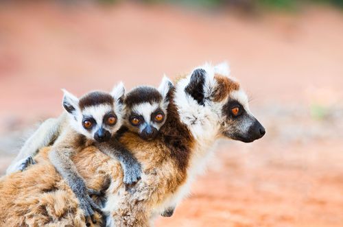
The twelve species of lemurs at Ranomafana have made it a key location for primatologists, who have one of the country’s foremost research stations at the park. Although the local Tanala people have long practised tavy – slash-and-burn agriculture – in the region (and successfully avoided falling under Merina rule, only losing their independence to the French), lemur-hunting wasn’t a major activity in this area, even before the park was created in 1991.
There are three species of bamboo lemur alone. Giant bamboo makes up much of the diet of the distinctive golden bamboo lemur (Hapalemur aureus, known as bokombolomena or varibolomena in Malagasy), first described as recently as 1986. Around 65 individuals in around fifteen different groups live in Ranomafana, to which they are almost entirely restricted. They feed from 6am to 9am, which is the most likely time to see them, moving deliberately through the forest, with occasional bursts of leaping between the vertical bamboo stems. Curiously, golden bamboos are highly tolerant of cyanide, a normally highly toxic chemical that builds up in the bamboo. The guides can usually find the golden bamboo lemurs, but you’re much less likely to be gifted with the sight of the exceedingly rare, back-from-the-brink-of-extinction greater bamboo lemur (Prolemur simus or varibolomavo in Malagasy), which is much larger and has ear tufts.
One unusual diurnal lemur you do have a good chance of seeing is the large and gregarious Milne-Edwards’ sifaka (Propithecus edwardsi), a dark-coated, fluffy-headed denizen of the canopy, often seen clumped together in a jumble of limbs and tails high in the branches. This lemur, of which at least 4000 of Madagascar’s total population of perhaps 9000 live in Ranomafana, has been studied intensively by the ValBio researchers, and several Milne-Edwards’ groups are habituated to unfamiliar visitors.
Mammal life isn’t confined to lemurs: the long-legged and rather beguiling eastern red forest rat (Nesomys rufus) often makes an appearance on the trails, keeping two wary eyes open for a local predator, the handsomely marked fanaloka (Fossa fossana), which despite its scientific name is more like a genet or civet – and very partial to rat.
Birds
Key Madagascan endemics of the forest include a tiny terrestrial rail, the local and elusive slender-billed flufftail (Sarothrura watersi); the brilliantly plumaged pitta-like ground roller (Atelornis pittoides); the exceedingly secretive and rare brown mesite (Mesitornis unicolor); the shrike-like Pollen’s vanga (Xenopirostris polleni); and the short-legged ground roller (Brachypteracias leptosomus), which you may spot – or more likely your guide may spot – perched on a low branch in the understorey, obligingly motionless for low-light photography. Also look out for the velvet asity (Philepitta castanea): the male of the species turns out smartly for the breeding season in shiny navy-blue-green, with fleshy turquoise trimmings, like a little turkey wattle, on his head.
Reptiles and amphibians
Herpetology enthusiasts will be enraptured by Ranomafana. Tree frogs perch, gulping, on branches above streams (the larger, creamy blue-throated specimens are called white-lipped bright-eyed frogs, Boophis albilabris). The undergrowth abounds with leaf-tailed geckos, including the unnerving and ragged-looking satanic leaf-tail (Uroplatus phantasticus), and its cousins the mossy leaf-tail (U. sikorae) and giant leaf-tail (U. fimbriatus). Roadside night walks reveal sleeping adult chameleons on every other branch and vulnerable hatchlings no bigger than a safety pin, clinging to the tips of leaves, eyes shut tight, instinctively poised to detect an approaching snake. Ranomafana’s standout chameleons are the handsome double-nosed O’Shaughnessy’s chameleon (Calumma oshaughnessyi) and the diminutive short-nosed chameleon (Calumma nasutum), with its comical, blue-tinted, Pinocchio-like proboscis.
Invertebrates
As ever, the forest is full of invertebrates, from mundanely unpleasant leeches (prevalent in the rains: keep your trouser legs tucked into your boots) to some of the world’s most inexplicably evolved insects – like the preposterous giraffe-necked weevil (Trachelophorus giraffa), a brilliant red bug as big as your thumb tip that is particularly common here. The males use their outlandishly long, black necks to fight for mating rights, like anglepoise lamps jousting, while the sturdy and more sensibly necked females make leaf nests from which a single grub will emerge.
Fianarantsoa
Madagascar’s third-biggest town, with a population of at least 160,000, FIANARANTSOA – often shortened to Fianar – was founded in 1830 as the Merina empire’s southern capital, although the location was originally a Betsileo village. In many ways like a smaller version of Antananarivo, Fianar has distinct districts at different altitudes: down at 900m, the lower town or Basse Ville, where you arrive, is full of hustle, diesel fumes and trade; in the architecturally fascinating old town of Haute Ville, 300m higher up, the streets are pedestrian only; in between, the more humdrum mid-town Nouvelle Ville neighbourhood is largely devoted to administration and banks and is crisscrossed by broad streets. This is where the tourist office and main market are located.
In practical terms, Fianar is more of a stopover than a travel hub. If you’re heading south, this is where the dry country begins; if you’re going north, it’s where the central highlands atmosphere is fully established. Hardy souls braving the Fianar–Côte Est railway will note that it’s also on the edge of the rainforest escarpment dropping down to Manakara and the Indian Ocean.
Brief history
The name Fianarantsoa means “Where the best is learned” or “Place of good learning” depending on your translator: either way, it has long been associated with education, and particularly with the kind of academic and moral improvement that the Merina elites believed they could impart to their local Betsileo subjects. Missionaries from Britain, France and Norway found receptive audiences here when they arrived in the nineteenth century and the town is still studded with churches: there are six in the old town alone. The French used it as their base of operations for the whole south of the island after 1895.
The Final–Côte Est railway
One of the last two remaining services of the once important Madagascar railways, the Fianar–Côte Est, first opened in 1936, runs a steadily reducing passenger service (now twice weekly) in each direction between Fianarantsoa and Manakara on the coast. In theory trains depart from Fianar at 7am on Tuesday and Saturday and from Manakara at 6.45am on Wednesday and Sunday. In practice, the only sure way of knowing when the train is departing is to be on it when it leaves. You may get information about the current state of readiness at the station at either end, but their guess will more than likely be just as good as yours. Seats in the decrepit first-class compartment (second class is not recommended) cost 25,000ar, with a compulsory 15,000ar reservation fee, and can be bought at the station ticket offices. If the train is delayed and you have to cancel, you can get a full refund: but get a proper written receipt to that effect when paying.
In theory, the train should arrive on the evening of the same day. In practice, it rarely reaches the other end until late at night or early the next morning (the scheduled departures from Manakara are optimistic given the usual arrival time from Fianar). Go prepared with food and drinks, mosquito repellent, and a well-charged flashlight or head torch. You can buy snacks along the way (indeed sampling the various items for sale at every one of the sixteen remote village stops en route is one of the highlights) but many villages are far from the roads and have little infrastructure, so don’t expect to find cold drinks.
The 170km route takes you through dense rainforest past waterfalls, and the photographic opportunities in the villages can be excellent if you’re well positioned. However, frequent breakdowns, unexplained stops, lack of lighting, inadequate toilets, and the fact that more passengers seem to get on than get off at every stop, means that even if you managed to depart in the morning more or less on time, by late afternoon you’re likely to be facing a long and dauntingly uncomfortable night.
Haute Ville
Even if you’re only pausing in Fianar for a break and a bite to eat, the alleys and houses of the Haute Ville – also known as the old town, or Tanana Ambony – make for a captivating, and surprisingly panoramic, walk. Vehicles have to be parked in front of the Ambozontany Cathedral at the foot of the main staircase-lane that runs up the old town hill. To avoid hassle, and to be informed along the way, it’s a good idea to take a good guide. It’s only a ten-minute walk up to the crown of the hill, where multiple beautiful old houses are in various states of repair, some actively being restored and lived in, others invaded by weeds (in 2008 a private American non-profit, the World Monuments Fund, included the old town of Fianar as one of the 100 most threatened historical sites in the world). Many of the houses have brick columns supporting their first-floor ornamental balconies (or lavarangana).
A thirty-minute promenade along the cobbled pathway takes you right around the hilltop. Look west and you’ll see Lac Anosy (copied from the lake of the same name in Tana by Queen Ranavalona I, who moved her court to Fianar in 1830), a popular late afternoon strolling area for locals. Past the 1859 Antranobiriky church at the summit you’ll reach a dusty school playground, where a plaque commemorates this as the site of the nineteenth-century Merina rova. A low fence of brightly painted stakes still symbolically protects the site along its western boundary.