The Sperrins
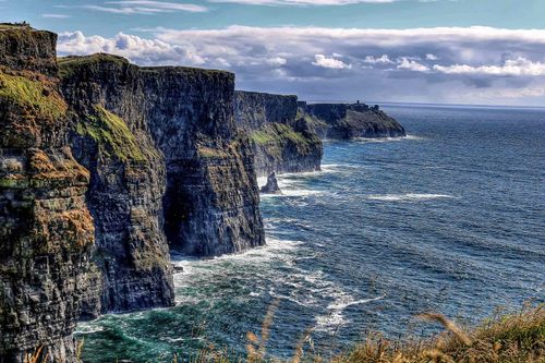
The impressive, undulating Sperrin Mountains form the northeastern limits of County Tyrone. Wild, empty and beautiful, they reach 2240ft at their highest point, yet the smooth and gradually curving slopes give them a deceptively low appearance. The covering of bog and heather adds to this effect, suggesting nothing more than high, open moorland. For all this, views from the summits are panoramic, and the evenness of texture can make these mountains sumptuous when bathed in evening light. Once in the mountains, it’s impossible not to catch sight of the wildlife. Sparrowhawks and kestrels hover above, and you might see buzzards or the far more rare hen harrier, attracted by a rich range of prey in a landscape mostly undisturbed by development – the mountains teem with assorted rodents, including even the rare Irish hare. Over the years there’s been many a tale about the discovery of “gold in them there hills” and you might encounter the occasional panner testing the story’s veracity.
Gortin
The best base for exploring the Sperrins is GORTIN, ten miles north of Omagh, a long one-street village with a surprising number of pubs. Three miles south of the village is the Gortin Glen Forest Park, with a five-mile forest drive and various trails leading to viewpoints of the area – look out for members of the park’s herd of Sika deer.
The Beaghmore Stone Circles
Tyrone is peppered with archeological remains: there are more than a thousand standing stones in the Sperrins alone, and the county as a whole boasts numerous chambered graves. The most impressive relics are the Bronze-Age Beaghmore Stone Circles, in the southeast of the Sperrins. From Gortin, take the B46 east onto the A505, from where they’re well signposted up a track three and a half miles north off the road. Although most of the stones on this lonely site are no more than a metre high, the complexity of the ritual they suggest is impressive: there are seven stone circles, ten stone rows and a dozen round cairns (burial mounds, some containing cremated human remains). All of the circles stand in pairs, except for one, which is filled with over eight hundred upright stones, known as the Dragon’s Teeth. The alignments correlate to movements of the sun, moon and stars; two of the rows point to sunrise at the summer solstice.
Walking the Sperrins
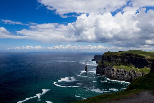
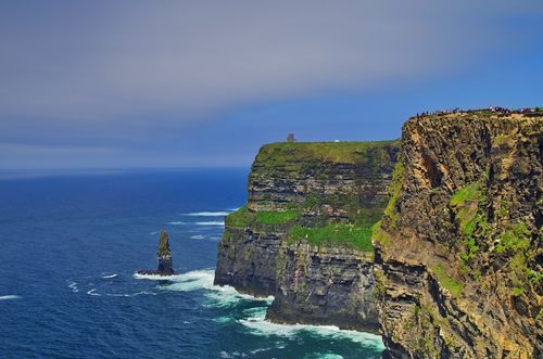
The forty-mile-wide range of the Sperrin Mountains offers good long-distance walking, without necessarily involving steep inclines. You can ramble wherever you like, but remember that – despite appearances – these are high mountains, and changeable weather makes them potentially dangerous. A map and compass are essential for serious walking.
For those not equipped for the high ground, the Glenelly and Owenkillen river valleys run through the heart of this fine countryside from Plumbridge and Gortin, respectively, and are particularly enjoyable for cyclists who should pick up a copy of the Sperrins cycling guide from tourist offices (also downloadable from wwww.sperrinstourism.com). The Central Sperrins Way (map available from most tourist offices) is a 25-mile waymarked trail, which begins and ends at Barnes Gap, halfway between Plumbridge and Cranagh. The two-day walk takes in a variety of countryside with spectacular views of the mountains, moorland and Glenelly Valley. The exposed moorland can often be very wet and boggy underfoot, and, as there is no accommodation en route, taking a tent is essential.
The Sperrins Walking Festival (t028/8634 7700, wwww.sperrinstourism.com) is held over the first weekend in August and involves various guided daily walks, graded according to difficulty.
Eastern Tyrone
The only places in the east of County Tyrone that could be described as anything more than villages are the rather drab towns of Cookstown and Dungannon. The dominant feature is the western shore of Lough Neagh, and there are a number of relics of both the region’s historical heritage, such as the high cross at Ardboe, and its more recent industrial past at the Wellbrook Beetling Mill, close to Cookstown. The village of Benburb, to the south, is one of the most attractively situated in the North.
Benburb
Seven miles northwest of Armagh, the picturesque village of BENBURB merits a detour. Main Street’s tiny cottages were once apple-peeling sheds, and the parish church, dating from 1618, is one of the oldest still in regular use in Ireland. It stands next to the gates of a Servite priory – the monastic order of Servants of the Virgin, which, though founded in Florence in 1233, did not establish itself in Ireland until 1948. The priory grounds offer a pleasant stroll, but far better are the walks along the Blackwater River in Benburb Valley Park (daily 9am–dusk; free), accessed from Main Street, where, perched on a rock thirty metres or so above the water, are the substantial remains of a castle built by Viscount Powerscourt in 1615, which offer commanding views of the Blackwater valley.
Lough Erne
Lough Erne has a profoundly important place in the history of Fermanagh. The earliest people to settle in the region lived on and around the two lakes; many of the islands here are in fact crannógs. The lough’s myriad connecting waterways were impenetrable to outsiders, protecting the settlers from invaders and creating an enduring cultural isolation. Evidence from stone carvings suggests that Christianity was accepted far more slowly here than elsewhere: several pagan idols have been found on Christian sites, and the early Christian remains to be found on the islands show the strong influence of pagan culture. Here, Christian carving has something of the stark symmetry, as well as a certain vacancy of facial expression, found in pagan statues. Particularly suggestive of earlier cults is the persistence of the human-head motif in stone carving – in pagan times a symbol of divinity and the most important of religious symbols.
Devenish Island and White Island, the most popular of the Erne’s ancient sites, are on the Lower Lough, as is Boa Island in its far north, which is linked to the mainland by a bridge at each end. The Upper Lough is less rewarding, but has interesting spots that repay a leisurely dawdle. Aside from cruising the waterways and visiting the islands, there are a number of minor attractions around the loughs that are worth dropping into during your stay. Perhaps the most impressive are the early seventeenth-century planters’ castles scattered around the shoreline.
Devenish Island
Devenish Island is in Lower Lough Erne and can be reached by ferry from Trory Point, three miles north of Enniskillen off the A32 Irvinestown road. A monastic settlement was founded on Devenish by St Molaise in the sixth century and became so important during the early Christian period that it had 1500 novices attached. Though plundered by Vikings in the ninth and twelfth centuries, it continued to be a major religious centre up until the early 1600s. It’s a delightful setting, not far from the lough shore, and the ruins are considerable, spanning the entire medieval period. Most impressive are the sturdy oratory and perfect round tower, both from the twelfth century; St Molaise’s church, a century older; and the ruined Augustinian priory, a fifteenth-century reconstruction of an earlier abbey with a fine Gothic sacristy door decorated with birds and vines. To the south is a superb high cross, with highly complex, delicate carving. Other treasures found here – such as an early eleventh-century book shrine, the Soiscel Molaise – are now kept in the National Museum in Dublin, while the island’s own small museum includes other less notable relics and detailed information about Devenish itself.
Book tickets and tours in Dublin
Western Fermanagh
The stretch of countryside on the western edge of the county offers some good walking opportunities, particularly in the hills to the south. The Ulster Way, which runs northwest from the Upper Lough and east towards Tyrone, makes the riches of the terrain easily accessible. This region also has two attractions that are well worth seeking out. The magnificent eighteenth-century Florence Court is the most assured achievement of the colonists, built 150 years after the initial defensive planters’ castles. If you have your own transport, a visit to the house can be combined with an hour or so at the Marble Arch Caves, the finest cave-system in Northern Ireland.
Florence Court
The magnificent three-storey mansion of the National Trust–owned Florence Court, about eight miles southwest of Enniskillen, was commissioned by John Cole, one of the Earls of Enniskillen, and named after his wife. The house, completed around 1775, is notable for its restored rococo plasterwork and rare Irish furnishings; the dining room is especially lavish, its ceiling hosting a cloud of puffing cherubs with Jupiter disguised as an eagle in the centre, all flying out of a duck-egg-blue sky. Unfortunately, the top floor of the house was completely destroyed by a fire in 1955 and has never been renovated internally.
The Marble Arch Caves and around
Fermanagh’s caves are renowned, and while some are for experts only, the most spectacular system of all, the Marble Arch Caves, five miles west of Florence Court, is accessible to anyone of average fitness or above. A tour of the system lasts around an hour and a quarter, beginning with a boat journey along a subterranean river, then on through brilliantly lit chambers, calcite-walled and dripping with stalactites and fragile mineral veils. Tours of the caves are sometimes booked out by parties, so it’s worth calling ahead; in a steady Irish downpour the caves can be flooded, so check weather reports as well. You’ll need sturdy walking shoes and warm clothing as the temperature can drop significantly.
From whichever direction you approach the caves, you’ll travel along the Marlbank Scenic Loop, with tremendous views of Lower Lough Macnean, and on either side you’ll see limestone-flagged fields, much like those of The Burren in County Clare. It was fifty thousand years of gentle water seepage through the limestone that deposited the calcite for the amazing stalactite growths in the caves below.
Almost opposite the caves’ entrance is the Legnabrocky Trail, which runs through rugged limestone scenery and peatland to the shale-covered slopes of Cuilcagh Mountain. This forms part of an environmental conservation area and offers a strenuous six- or seven-hour walk to the mountain’s summit and back (be prepared to turn back if the weather turns sour). A part of the Marble Arch Caves centre is now devoted to an exhibition describing the restoration of the mountain park’s damaged peatland and bogland habitats.
The Ulster Way
From Marble Arch Caves the Ulster Way heads past Lower and Upper Lough Macnean before traversing the bog and granite heights of the Cuilcagh Mountains to Ballintempo Forest with its fabulous views over the loughs. The Way then continues north, through the Lough Navar Forest, a well-groomed conifer plantation with tarmacked roads and shorter trails. Although a great deal of fir-plantation walking is dark and frustrating, this forest does, at points, provide some of the most spectacular views in Fermanagh, looking over Lower Lough Erne and the mountains of surrounding counties. The Lough Navar Forest also sustains a small herd of red deer, as well as wild goat, fox, badger, hare and red squirrel.