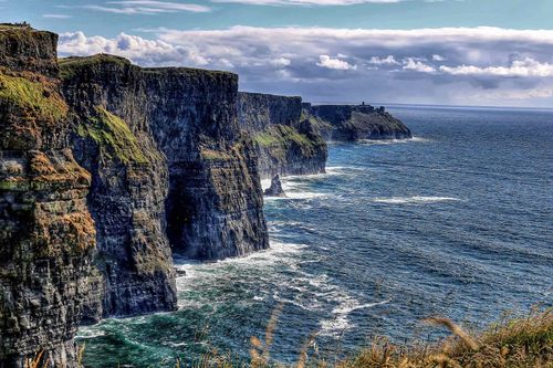
Antrim and Derry Travel Guide

Much of the coastline of County Antrim is as spectacular as anything you’ll find across the whole of Ireland and, consequently, unlike other parts of the North, it has always attracted an abundance of tourists.

North from the ferry port of Larne, the A2 coast road takes in attractive villages and small towns, such as Carnlough, Cushendall and the port of Ballycastle, all set against or within the verdant Antrim Glens. A short boat trip from Ballycastle lies rugged Rathlin Island, while further along the coast to the west, blustery cliff-top walks lead to the strange basalt formations of the Giant’s Causeway. With an attractive backdrop, Portrush and, just over the border in Derry, Portstewart are popular seaside holiday resorts.

Book Cliffs of Moher tickets and tours

County Derry’s coastline is also blessed with wonderful strands, overlooked by Mount Binevenagh and the eccentric Mussenden Temple. Derry city itself is a lively place, set on the banks of the Foyle, with its hilltop core still enclosed by some of the best-preserved city walls in Europe. The county’s hinterland is more dramatic than Antrim’s, especially where it skirts the Sperrin Mountains around historic Dungiven. The flatter territory towards Lough Neagh features some noteworthy Plantation settlements at Magherafelt and Moneymore.

North from Belfast

The coastal strip from Belfast to Larne is largely uninspiring farmland, although there are a few spots to detain you as you head towards the more enticing Antrim Glens further north.

Heading out of Belfast’s northern suburbs, the A2 skirts the edge of Belfast Lough before reaching CARRICKFERGUS, an unremarkable seaside town whose seafront is dominated by its only real point of interest, well-preserved Carrickfergus Castle, one of the earliest and largest Irish castles.

A dozen or so miles north of Carrickfergus lies LARNE, an important freight centre, if a rather grim town, and one of the main ports of entry to Northern Ireland, served by P&O ferries from Cairnryan and Troon and Stena Line services from Fleetwood.

Three-quarters of a mile north of Larne on the Antrim coast road stands a large monument to the engineer of this road, William Bald, and his stalwart workers, who blasted their way through, over and round the cliffs and rocky shoreline to create this route in the 1830s. The impressive scale of this achievement becomes apparent the moment you leave Larne’s dull suburbs and the view expands to take in the open sea and, beyond it, the low outline of the Scottish coast. About three miles north of Larne, Carnfunnock Country Park is a good place to stop for a walk, with a walled garden, a time garden – with a collection of sundials ranging from the simple to the arcane – a maze in the shape of Northern Ireland, a miniature railway, and a nine-hole mini-golf course.

The Glens of Antrim and Rathlin Island

Northwest of Larne lie the nine Glens of Antrim, a curious landscape in which neat seaside villages contrast vividly with the rough moorland above. Despite their proximity to the Scottish coast, the Glens were extremely isolated until the completion of the coast road in the 1830s. Their largest town is Ballycastle, which is also the departure point for the ferry to rugged Rathlin, Northern Ireland’s last inhabited offshore island, in one of whose caves Robert the Bruce of Scotland acquired a legendary lesson in patience from a spider spinning and respinning its web. The best base for exploration of the area, though, is Cushendall, a charming village 26 miles along the coast from Larne.

Carnlough

CARNLOUGH stands at the head of Glencloy. Until the 1960s, Carnlough’s way of life was linked to its limestone quarries, and the village’s most striking feature today remains its sturdy limestone buildings, dating mainly from the mid-nineteenth century. Right in the village centre, running over the main road, there’s a solid stone bridge that once carried a railway bringing material down to the harbour, which itself has an impressive breakwater, clock tower and limestone courthouse.

Cushendall

CUSHENDALL, which lies at the head of three of the nine Glens, is a delightfully understated village, its charming colour-washed buildings grouped together on a spectacular shore. The red-sandstone tower at the central crossroads was built in 1817 by one Francis Turnley, an official of the East India Company, as “a place of confinement for idlers and rioters”, and, though there’s little else to see here, the village makes a fine base for exploring the local countryside and catching a traditional-music session. If at all possible, time your visit to coincide with the Heart of the Glens festival (wwww.glensfestival.com) in the middle of August, one of the area’s oldest events, replete with traditional music, sporting events and much merriment, culminating in a huge street ceilidh on the Sunday.

Ballycastle

The lively market town and port of BALLYCASTLE sits at the mouth of the two northernmost Antrim Glens, Glenshesk and Glentaisie, and makes a pleasant base for exploring the Causeway Coast or the Glens themselves. The best time to visit Ballycastle is at the time of the Ould Lammas Fair, Ireland’s oldest fair, dating from 1606. Held on the last Monday and Tuesday in August, it features sheep and pony sales. Stallholders do a roaring trade in dulse, an edible seaweed, and yellowman, a tooth-breaking yellow toffee that’s so hard it needs a hammer to break it up.

The north Antrim coast

The north coast of County Antrim, west of Ballycastle, is dominated, from a tourist perspective, by Northern Ireland’s most famous tourist attraction, the bizarre formation of basalt columns at the Giant’s Causeway. On the way, near the town of Ballintoy, there are several pleasant diversions, not least the precarious rope bridge to Carrick-a-rede Island. West of the Causeway, you can sample some whiskey at Bushmills and visit the imposing and well-preserved remains of Dunluce Castle, the stronghold of the local MacDonnell clan. The coastline west of Dunluce is another major holiday spot, with the resort of Portrush filled with tourists in July and August and students the rest of the year.

Portrush

The town of PORTRUSH, on the Ramore Peninsula, has everything you’d expect from a seaside resort, from sandy beaches backed by dunes, which run both east and west, to summer drama in the town hall and plenty of amusements for children. Many students from the University of Ulster at Coleraine live here and make it a considerably livelier place than you might expect, even out of season; the huge popularity of the local dance scene draws clubbers from all over the North and the town can have a distinctly raucous feel at weekends. The long, sandy beach towards Dunluce ends at the White Rocks, where the weather has carved the soft limestone cliffs into strange shapes, most famously the so-called “Cathedral Cave”, nearly 60m from end to end.

Northern County Derry

West of Portrush the A2 continues to hug the coastline as it traverses the northern part of County Derry, taking in marvellous beaches all the way from Portstewart, near which it crosses the River Bann, to Magilligan Point. On the way there are impressive seascapes visible from the clifftop Mussenden Temple and stunning views from the land around Mount Binevenagh. The land becomes drabber as the road nears the small manufacturing town of Limavady, which retains a few remnants of Georgian times.

Portstewart

Derry’s largest coastal resort, PORTSTEWART, like its near neighbour Portrush, is full of Victorian boarding houses. Of the two, Portstewart is decidedly more sedate and has always had more airs and graces: the train station is said to have been built a mile out of town to stop hoi polloi from coming. In terms of sheer location, though, Portstewart wins hands down. Just west of the town is Portstewart Strand, a long sand beach firm enough to drive on – which the locals delight in doing – with some of the best surfing in the country. It’s a grand place, too, if you hit fine weather and feel like getting out your bucket and spade. The best way to take the sea air is the bracing cliffside walk, which runs between the beach and the town, passing battlements and an imposing Gothic mansion, now a Dominican college.

Downhill Palace and Mussenden Temple

A mile west of the coastal resort of Castlerock, a pair of huge, ornate gates alongside the A2 mark the main entrance to the ruins of Downhill Palace, built in the 1780s by Frederick Augustus Hervey, Anglican Bishop of Derry and fourth Earl of Bristol. Hervey was an enthusiastic grand traveller (all the many Hotel Bristols throughout Europe are named after him), and was also an art collector and great sportsman, once organizing a pre-prandial race between Anglican and Presbyterian clergy along the local strand. His palace, accessed through pleasant gardens, was last occupied by US troops, billeted here during World War II, and was dismantled on their departure.

Across fields at the back of the palace is the diminutive Mussenden Temple, which clings precariously to the eroding cliff-edge and offers stunning sea views. Its classic domed rotunda was apparently modelled on the Temple of Vesta in Rome and was built by Hervey in honour of his cousin Mrs Frideswide Mussenden, who died aged 22 before it was completed, after which it was used as a summer library. Later, with characteristic generosity and a fairly startling lack of prejudice, Hervey allowed a weekly Mass to be celebrated in the temple, as there was no local Catholic church. The inscription on the temple frieze translates rather smugly as: “It is agreeable to watch, from land, someone else involved in a great struggle while winds whip up the waves out at sea.”

Just west from here the A2 curves steeply downwards to reach the appositely named DOWNHILL hamlet, on the edge of the hugely long beach. From here it’s possible to take the Bishop’s Road (constructed at Hervey’s bidding) southwards to reach Mount Binevenagh and its fabulous viewpoints. The land around the mountain is now a conservation park, dedicated to the preservation of birds of prey, in particular falcons and kestrels.

The Siege of Derry

Derry’s walls underwent – and withstood – siege on a number of occasions during the seventeenth century. The last of these, in 1688–89, played a key part in the Williamite army’s victory over the Catholic James II at the Battle of the Boyne, when the Derrymen’s obduracy crucially delayed the plans of James and his ally Louis XIV to maintain Catholic ascendancy over the kingdom.

The suffering and heroism of the fifteen-week siege, the longest in British history, still have the immediacy of recent history in the minds of Derry Protestants. James’s accession in 1685 had seen the introduction of a policy of replacing Protestants with Catholics in leading positions in the Irish administration and army. In December 1688, a new garrison attempted to enter the city, but was prevented when a group of young apprentices seized the keys and locked the city’s gates. Eventually, after negotiation, an all-Protestant garrison under Governor Robert Lundy was admitted. Over the following few months the city’s resident population of two thousand swelled to thirty thousand as people from the surrounding area took refuge from Jacobite forces advancing into Ulster. Fearing that resistance against the Jacobite army was futile, Lundy departed; his effigy is still burnt each December by Protestants. Around seven thousand Protestants died during the siege that followed, the survivors being reduced to eating dogs, cats and rats. Today, the siege is commemorated with a skeleton on the city coat of arms, and the lyrical tag “maiden city”, a somewhat sexist reference to the city’s unbreached walls.

The walls

The best approach to Derry's walls is from the Guildhall Square, once the old quay, east of Shipquay Gate. The Neogothic ecclesiastical appearance of the Guildhall belies its true function as the headquarters of the City Council. Inside, the city’s history is depicted in a series of stained-glass windows. Most of the city’s cannons are lined up opposite here, between Shipquay Gate and Magazine Gate, their muzzles peering out above the ramparts. A reconstruction of the medieval O’Doherty Tower here houses the Tower Museum, whose showpieces are a series of stimulating displays and galleries recounting the city’s history and a splendid exhibition, spread over four storeys, focused on Spanish Armada Treasures, which features gold artefacts and finely worked jewellery from La Trinidad Valencera, which sank in Kinnegoe Bay (off Inishower) in 1588.

Southern County Derry

The Derry–Antrim A6 road follows a river valley through fertile farming land before reaching Dungiven, a former political and religious power-base with ruined evidence of its former glories, then ascends to the Glenshane Pass on the northeastern fringe of the Sperrin Mountains. Southeast from here are Magherafelt and Moneymore, two attractive and entirely planned towns, the latter adjacent to the grand Plantation manor house of Springhill. The huge expanse of Ireland’s biggest lake, Lough Neagh, laps against the county’s southeastern corner and here too is one of the must-see sights of the entire North, Bellaghy Bawn castle.

Dungiven

DUNGIVEN, some twenty miles southeast of Derry, is a fairly unremarkable town, though it does harbour one or two ruins of interest, including the ruined Augustinian Dungiven Priory. Originally a stronghold of the O’Cahan clan, Dungiven was given to the Skinners’ Company of London to settle in the seventeenth century. The remains of the O’Cahan fortifications are incorporated into the newly restored castle, whose battlemented outline gives Dungiven a particularly historic aspect when approached from the south. The castle dates back to 1839 and is set in 22 acres of parkland with views across to the Sperrins. During World War II, it was used as a dance hall by American troops, and in 1971 it was the scene of an attempt to set up an independent Northern Ireland parliament. Following restoration work, it now houses upmarket guesthouse accommodation and a restaurant.

Book tickets and tours in Cork

Lough Neagh

East of Magherafelt and Moneymore are the fish-filled waters of the biggest lake in Ireland, Lough Neagh. Tributaries flow from every point of the compass: the Lower Bann, which drains the lake and runs north to Lough Beg (finally reaching the sea north of Coleraine), contains some huge trout, including the dollaghan, unique to these waters. Similar to salmon – which are also common – dollaghan grow by three pounds every year and can be caught by spinning, worming and fly-fishing: the Ballinderry Black and the Bann Olive are famous flies derived from this region. The best fishing is from mid-July to October but you will need a Fisheries Conservation Board Rod licence, available from tourist offices. Information on day-tickets for fishing and specialist boat-trips, respectively issued and run by the Lough Neagh Angling Association, can also be obtained from the tourist office.

Bellaghy Bawn

One of the best surviving examples of a plantation castle is Bellaghy Bawn, built in 1618 by the Vintners’ Company. Most of its fortifications were lost in 1641, but it still retains a striking circular flanker tower which has been well restored. Inside you’ll find fascinating interpretive displays explaining the 7000-year-old history of the settlements in this area, the construction of the village – today’s houses still occupy the same original allocated plots of land – and the diverse ecology of the Lough Beg wetland area. The real treasure here, however, is the dedication of much of the Bawn’s space to one of the world’s greatest living poets, Seamus Heaney, who was born and raised nearby. Heaney himself is the star of a unique and atmospheric film showing in the Bawn, A Sense of Place, in which he reflects on the influence of his upbringing, local character and landmarks on his poetry. His father, for instance, rented grazing rights on the strand at Lough Beg; in his poem Ancestral Photograph, Heaney recalls helping to herd the cattle that grazed there down Castle Street on their way to market. Prints of other poems are displayed on the walls of various rooms, and the Bawn’s library contains the ultimate collection of his works, including first drafts and extremely limited editions.

You can see the shimmering Lough Beg from the windows of the flanker tower, and a stroll down to the lake is well worthwhile. In summer, its waters recede and Church Island becomes accessible from the shore. Besides a walled graveyard, you’ll find the ruins of a medieval church here, said to have been founded centuries before by the ubiquitous St Patrick, with a tower and spire added in 1788 by the eccentric Frederick Augustus Hervey to improve his view from Ballyscullion House on the mainland nearby. He commissioned Charles Lanyon to build a huge replacement for the original house which stood here, with, apparently, 365 windows, but died abroad before ever moving in, and the building subsequently fell into ruin.

The plantation towns

Southeast of Dungiven and over the Glenshane Pass on the way to the northern tip of Lough Neagh, it is worth making a detour to see some interesting examples of town planning – the plantation towns of the London companies, most of them characteristically focused around a central Diamond.

One such town is MAGHERAFELT, granted to the Salters’ Company by James I, which has a wide, sloping main street and makes a reasonable base for exploring the lough and the Bellaghy area. MONEYMORE, about five miles further south, was originally constructed by the Drapers in the early seventeenth century (and restored by them in 1817), and was the first town in the North to have piped water – amazingly enough, as early as 1615.

A mile outside town off the B18, Springhill is a grand plantation manor-house built between 1680 and 1700 by William “Good- Will” Conygham in order to fulfil a marriage contract with the father of his bride- to-be, Anne Upton. Elegant both without and within, its sober whitewashed architecture houses fine rooms, equipped with original period furniture and paintings belonging to William and his descendants, who occupied the house until 1959. Upstairs, the Blue Room is said to be haunted by the ghost of Olivia Lenox- Conyngham, whose husband George was found shot here in 1816. Outside, the stables house a costume collection, which adopts a specific theme each year, drawing upon three thousand items collected from the mid-seventeenth century to the 1970s. There are also delightful gardens, a tower dating from the 1730s, which was probably originally part of a windmill, and a pleasant walk through beech and yew trees.

Seamus Heaney

It’s impossible to conceive of a contemporary poet, Irish or otherwise, whose works are more evocative of time and place than Seamus Heaney. He was born, the eldest of nine children, on the family farm of Mossbawn (itself the title of two poems in his fourth collection, North), in the townland of Tamniarn, near Bellaghy, on April 13, 1939. Heaney’s family background, his Catholic upbringing and his study of Irish at school imbued him with a strong sense of being Irish in a state that considered itself British, a paradox that would form a major motif in his work during the 1970s. While at Queen’s University, Belfast, he was further influenced by the literature he discovered in Belfast’s Linen Hall library, especially the works of John Hewitt, the Antrim-born “Poet of the Glens”, and the English “naturalist” poet Ted Hughes, in whose work he found an “association of sounds in print that connected with the world below”. The rural Monaghan setting of Patrick Kavanagh’s poetry further echoed his own experience and vision.

Book ticket and tours to EPIC Irish Immigration Museum

Heaney’s first poem, Tractors, was published in the Belfast Evening Telegraph in 1962. His first significant collection, Death of a Naturalist, followed in 1966 and was immediately recognized for its earthiness and command of diverse metrical forms. In the 1960s, while lecturing at Queen’s, Heaney’s career expanded into journalism and television and he became increasingly involved in the civil-rights movement. His response to the Troubles saw him seeking for “images and symbols adequate to our predicament” and he began to see poetry as a mode of resistance. Eventually, though, the violence so disturbed him that he moved with his family to County Wicklow, prompting Ian Paisley’s Protestant Telegraph to bid farewell to “the well-known papist propagandist” on his departure to his “spiritual home in the popish republic”. While his 1970s collections North and Field Work had mixed receptions – some saw the strong influence of Robert Lowell on the former – Heaney found himself turning increasingly to his Irish heritage as a source of inspiration, particularly the long medieval poem Buile Suibhne (The Madness of Sweeney), and published his own Sweeney Astray collection in 1983. The following year’s Station Island drew on his experiences as a participant in St Patrick’s Purgatory.

The hunger strikes of the early 1980s brought a new urgency to Northern politics and a revival of Heaney’s polemicism. Prompted by the staging in Derry in 1980 of Brian Friel’s play Translations, which showed English surveyors travelling through eighteenth-century Ireland anglicizing all the place names, Heaney cofounded the Field Day Theatre Company with Friel, his old friend and fellow academic Séamus Deane, the actor Stephen Rea and others. While the group’s theatrical activities were themselves controversial, it was their publications that engendered the most antipathy. Their pamphlets were criticized as attempts to over-intellectualize the Troubles and the 1991 Field Day Anthology of Irish Writing was decried for its under-representation of work by women writers, though a subsequent volume entirely devoted to them has since been published.

Heaney’s reputation, however, has remained largely unsullied, maintained not merely by the sheer literary strength of his work and its ready accessibility, but by his undoubted charisma and a lack of pomposity. In 1995, his body of work was more widely recognized by the award of the Nobel Prize for Literature. Heaney’s recent works include: a translation of the Anglo-Saxon epic poem Beowulf, his dramatic retelling of this tale of monster- and dragon-slaying managing to breathe new life into a work that was long considered too dense and metaphorical for a modern readership; and his collection, District and Circle, which won the prestigious T.S. Eliot Prize for Poetry in 2006.

Derry city

DERRY, which lies at the foot of Lough Foyle, is a crossroads city in more ways than one: roads from all cardinal points arrive here, but it was also a major point of emigration from the eighteenth century onwards, an exodus that reached tumultuous proportions during the Great Famine. Derry is the fourth largest city in Ireland and the second biggest in the North, but it has a markedly different atmosphere from Belfast, being two-thirds Catholic. While roads into the city are signposted in Irish welcoming visitors to Derry, the city still appears as “Londonderry” on many road maps and signs, a preference adhered to by the British government, Unionists and television news bulletins. Indeed, it has also acquired the nickname “Stroke City” – a reference to the tactful placating of both Nationalist and Unionist traditions by entitling it “Londonderry/Derry”. Whatever the case, locals of both persuasions now generally refer to their city as “Derry”.

Outside Ireland, the name of Derry recalls the Troubles and savage events like the Bloody Sunday massacre. Unlike Belfast, the cutting edge of violence receded considerably here even before the ceasefires, and the city is still imbued with a real sense of optimism, despite losing trade to nearby Letterkenny whenever the euro falls against the pound.

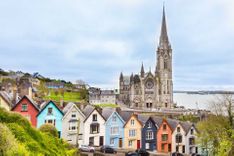
Approached from the east in winter twilight or under a strong summer sun, the city presents a beguiling picture, with the vista of the River Foyle and the rise of the city’s two hillsides, terraced with pastel-shaded houses and topped by the hueless stone spires of the ever-present religious denominations. With its rich history, Derry has several worthwhile attractions, mostly enclosed within the seventeenth-century walls, one of the best-preserved defences in Europe. A mile in length and as high as a two-storey house in places, the walls are reinforced by bulwarks and bastions and a parapeted earth rampart as wide as any thoroughfare. Within their circuit, the original medieval street-pattern has remained, with four gateways surviving from the original construction, albeit in slightly revised form. A tour of the walls also includes views of the Catholic Bogside area, whose political murals symbolize key moments in Derry’s history during the Troubles.

Some history

Though St Columba established a monastery here in 546 AD, the development of Derry (originally called Doire Calgaigh, “oakwood of Calgach”, after a legendary warrior) only really began in medieval times, when in the fourteenth century it was granted to the Anglo-Norman de Burgos. By 1500, the power of the O’Dohertys had spread from Inishowen and they constructed a tower house, which was later absorbed into the seventeenth-century walls.

Towards the end of the sixteenth century the uprising of Hugh O’Neill, Earl of Tyrone, provoked an English invasion. Doire’s strategic position on the River Foyle was quickly appreciated though it took some years for it finally to be captured. In 1600, the English commander Sir Henry Docwra began fortifying the remains of the medieval town as a base for incursions against the Irish, but in 1608 Sir Cahir O’Doherty rebelled against Docwra’s successor, Pawlett, and burnt Doire, by now anglicized as Derry, to the ground. This destruction made the city ripe for the plantation of English and Scottish settlers, and the financial assistance of the wealthy businessmen of the City of London was obtained to achieve this. A new walled city was constructed and renamed Londonderry in 1613 in honour of its backers, the Twelve Companies of the Corporation of London.

The seventeenth century was the most dramatic phase of Derry’s evolution, culminating in the siege of 1688–89. Following this, many Derry people emigrated to America to avoid harsh English laws, and some of their descendants, such as the pioneer frontiersman Daniel Boone, achieved fame there. Derry’s heyday as a seaport came in the nineteenth century, a period when industries such as shirt-making began to flourish – by the beginning of the twentieth century the city was the largest shirt-manufacturer in the UK. However, after Partition, the North–South dividing line lay just a couple of miles from Derry’s back door, and the consequent tariffs reduced much of its traditional trade. The shirt industry began its long decline, finally being phased out in the face of much cheaper imports from Asia, and while the city has seen growth in chemical industries, it still suffers from high male unemployment.

Though Derry remained relatively peaceful after Partition, its politics were among the North’s most blatantly discriminatory, with the substantial Catholic majority denied its civil rights by gerrymandering geared towards ensuring the Protestant minority’s control of local institutions. In October 1968 Derry witnessed a two-thousand-strong civil rights march. Confronted by the batons of the Protestant police force and the notorious B Specials, rioting spilled over into the Catholic Bogside district and over eighty people were injured. The clash is seen by many as the catalyst for the modern phase of the Troubles: faith in the impartiality of the Royal Ulster Constabulary was destroyed once and for all, and the IRA was reborn a year or so later. The following year’s Protestant Apprentice Boys’ march was another significant step and, on January 30, 1972, came Bloody Sunday.

Nowadays, Derry is a lively and unexpectedly entertaining place to visit. The city has also undergone dramatic changes, with the construction of huge shopping centres and the Millennium Forum theatre, plus the developments of pleasant riverside walks along the Foyle. Its people, however, remain very much physically divided, with Catholics living to the west of the Foyle and Protestants mainly residing to the river’s east.

Bloody Sunday

For the first two years of the Troubles, the area of the Catholic Bogside area beyond the original “Free Derry” mural was a notorious no-go area, the undisputed preserve of the IRA, its boundary marked by a gravestone-like monument declaring, “You are now entering free Derry”. This autonomy lasted until 1972, when the British army launched Operation Motorman; the IRA men who had been in the area were tipped off, though, and got across the border before the invasion took place.

To the right of the “Bernadette Devlin” mural in the Bogside stands a memorial pillar to the thirteen Catholic civilians killed by British paratroopers (a fourteenth died later of his wounds) on “Bloody Sunday”, January 30, 1972, in the aftermath of a civil-rights demonstration. The soldiers immediately claimed they had been fired upon, an assertion later disproved, though some witnesses came forward to report seeing IRA men there with their guns. The bitter memory of the subsequent Widgery Commission’s failure to declare anyone responsible for the deaths festered in Catholic Derry, and pressure was maintained on successive governments to reopen investigations. In 1999, after years of mounting demands for a full examination, the British government established the Saville Inquiry, which conducted its proceedings in Derry’s Guildhall until moving to Westminster in 2002. It finally reported in June 2010, concluding that the British Army’s actions were “unjustified and unjustifiable”, that all those killed or wounded were innocent victims and that some soldiers had committed perjury in giving their evidence. At the time of writing it is unclear whether any prosecutions will ensue.

The Giant’s Causeway

Ever since 1693, when the Royal Society first publicized it as one of the great wonders of the natural world, the Giant’s Causeway has been a major tourist attraction. The highly romanticized pictures of the polygonal basalt rock formations by the Dubliner Susanna Drury which circulated throughout Europe in the eighteenth century did much to popularize the Causeway. Two of them are on show in the Ulster Museum in Belfast. Not everyone was impressed, though.

The fascinating Giant Causeway in Northern Ireland © Kanuman/Shutterstock

The polygonal basalt formations of the spectacular Giant's Causeway - shutterstock

A disappointed William Thackeray commented, “I’ve travelled a hundred and fifty miles to see that?”, and especially disliked the tourist promotion of the Causeway, claiming in 1842 that “The traveller no sooner issues from the inn by a back door which he is informed will lead him straight to the causeway, than the guides pounce upon him.”

Although the tourist hype is probably now less overtly mercenary, the Causeway still attracts hundreds of thousands of visitors annually, filling the visitor centre and the minibus that scurries back and forth. But even in high season it’s easy to escape the crowds by taking to the cliffs.

For sheer otherworldliness, the Causeway can’t be beaten (or maybe it can, by one of the other weird places around the world?). It is made up of an estimated 37,000 black basalt columns, each a polygon, mostly hexagons, with pentagons second, though sometimes the columns have as many as ten sides. It is the result of a massive subterranean explosion, some sixty million years ago, that stretched from the Causeway to Rathlin and beyond to the Isle of Islay, Staffa (where it was responsible for the formation of Fingal’s Cave) and the Isle of Mull in Scotland. A huge mass of molten basalt was spewed out onto the surface, which, on cooling, solidified into what are essentially crystals. Though the process was simple, when confronted with the impressive regular geometry of the columns it is difficult to believe that their production was entirely natural.

The walk to the Causeway

From the visitor centre, it’s wise to resist the temptation to follow the crowds on the ten-minute walk along the lane straight down to the Causeway. Also, better not take the minibus that runs every ten minutes, the only form of transport allowed here except bicycles. Instead take a far more scenic route – a round trip of roughly two miles.

Follow the cinder path up behind the visitor centre and round the edge of several promontories, from which you can gasp at the Causeway from above and watch the eider and gannets wheeling across from Ailsa Craig, thirty miles away in Scotland. A flight of 162 steps takes you down to sea level and a junction in the path. Following the path west will bring you to the Giant’s Causeway.

If you continue round the bay to the north you’ll reach a series of rock formations, the first of which is the twelve-metre basalt columns known as the Organ Pipes. Many of the other formations have names invented for them by the guides who so plagued Thackeray and his contemporaries – the Harp, for example. At least one formation, Chimney Point further north, has an appearance so bizarre that in September 1588 it persuaded the crew of the Girona, a ship of the Spanish Armada, to think it was Dunluce Castle, where they thought they might get help from the MacDonnells. Instead, their vessel was wrecked on the rocky shore at Port-na-Spánaigh, just before Chimney Point. Its treasure was recovered by divers in 1968, and some of the items are on show in the Ulster Museum in Belfast, and, the Tower Museum in Derry.

Fionn Mac Cumhaill: the Giant of the Causeway

According to mythology, the Giant of the Causeway was Ulster warrior Fionn Mac Cumhaill (also known as Finn McCool), and two legends of Fionn’s exploits provide an entertaining alternative to geologists’ explanations of the Causeway’s origins. In one, Fionn became besotted with a woman giant who resided on the Scottish island of Staffa (where the Causeway’s fault-line resurfaces) and constructed a highway across the sea by which he could travel to woo her. An alternative version of the story suggests that Fionn built the Causeway in order to head over to Scotland to give another giant a good kicking, but, when confronted by his enemy’s superior size, fled back to Ireland and hid in an extra-large cot which he’d persuaded his wife to construct. When the pursuing Scots giant arrived, he took just a glance at the sheer size of Fionn’s supposed “baby” and fled back to Scotland.

Rathlin Island

Rathlin Island lies five miles north of Ballycastle and just twelve miles west of the Mull of Kintyre in Scotland. Shaped like a truncated figure seven, Rathlin is an impressive, craggy place, with a coastline consisting almost entirely of cliffs, and a lighthouse at each tip. As the island’s width is never more than a mile, the sea dominates the landscape and its salty winds discourage the growth of vegetation – wind turbines harness this energy source for electricity generation. The presence of dry-stone walls and numerous ruined cottages indicates a time when the population was far larger than the hundred or so current inhabitants concentrated in Church Quarter.

Top image: The walled city of Derry in Northern Ireland © Lucky Team Studio/Shutterstock

Planning your own trip? Prepare for your trip

Use Rough Guides' trusted partners for great rates

Rough Guides Editors

written by
Rough Guides Editors

updated 07.09.2021

Ready to travel and discover
Ireland?

Get support from our local experts for
stress-free planning & worry-free travels

Plan my trip ⤍