On the premise that conservation and development can be compatible, land use in the reserve has three designations: core areas include the national parks, major archeological sites and the biotopos, areas of scientific investigation. The primary role of core areas is to preserve biodiversity; human settlements are prohibited though tourism is permitted. Surrounding the core areas are multiple-use areas where inhabitants, aided and encouraged by the government and NGOs, are able to engage in sustainable use of the forest resources and small-scale agriculture. The buffer zone, a 15km-wide belt along the southern edge of the reserve, is intended to prevent further human intrusion but contains many existing villages.
Fine in theory, particularly when you consider that much of the reserve borders protected lands in Mexico and Belize. In practice, however, the destruction of Petén’s rainforest proceeds virtually unchecked in many parts. Less than fifty percent of the original cover remains and illicit logging is reducing it further. Oil exploration is the other industry that has driven the destruction of the forest in the west of the reserve, as petroleum companies have pushed roads deep into the Parque Nacional Laguna del Tigre. Incredibly, successive Guatemalan governments have aided and abetted the oil companies, issuing concessions for exploration. As soon as a road exists, land-hungry migrants follow and slash-and-burn the forest and plant milpas, which they farm. After a few years the thin soil is depleted, and cattle ranchers move in. In 2003 the smoke from these fires was so thick that it even affected southern Texas, where children were sent home from school.
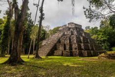
Although much has been lost in the west and south of the reserve, environmental groups are fighting to conserve what remains. Foreign funding provides much of the finance for protection, and NGOs are working with settlers to encourage the sustainable use of forest resources. Tourism is an accepted part of the plan and visitors are increasingly getting to remote biotopos and national parks – though numbers are still small. The forests and swamps of the Mirador Basin at the core of the reserve are still well preserved and have been spared thanks to the efforts of campaigning archeologists including UCLA’s Richard Hansen. In 2008 President Colom announced plans for a Mirador Basin National Park, a proposal that was still in development stage in 2012. It’s clear that a wilderness area, with limited or no road access is essential to safeguard what Hansen calls the “Cradle of Maya Civilization”.
Start planning your trip to Guatemala by first finding out how many days are best to spend in Guatemala.