Brief history
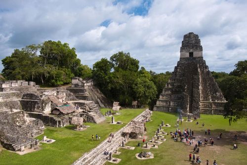
For almost two thousand years from 1000 BC onwards, Maya culture reached astounding architectural, scientific and artistic achievements. Petén was at the heart of this magnificent culture: great cities rose out of the forest, surrounded by huge areas of raised, irrigated fields and connected by a vast network of causeways. But climatic changes provoked the fall of the Preclassic Maya in northern Petén about AD 150, and, incredibly, history repeated itself seven centuries later when high population densities and a prolonged drought provoked the collapse of the Classic Maya. At the close of the tenth century, the great cities of Petén were abandoned, after which some Maya moved north to Yucatán, where their civilization flourished until the twelfth century.
Around Flores
The lakeside around Flores has several attractions that work well on a family tour in Guatemala, including a quirky island museum, the peaceful villages of San Andrés and San José, the Maya ruins of Motul, Tayasal and Nixtun Chi’ch’, a zoo and a wildlife rehabilitation centre.
Boatmen in Flores offer trips around the lake, charging around US$30 to visit two or three of the main attractions. You’ll find them waiting for business behind the Hotel Santana, in the southwestern corner of Flores, and by the public boat dock to San Miguel.
Forest gum
In the past, the mainstay of both San Andrés’ and San José’s economies was chicle, the sap of the sapodilla tree, used in the manufacture of chewing gum. The arduous and poorly paid job of collecting chicle involves setting up camps in the forest, and working for months at a time in the rainy season when the sap is flowing. Today natural chicle has largely been superseded by artificial substitutes, but there is still a demand for the original product, especially in Japan. Other forest products are also collected, including xate (pronounced “shatey”), palm leaves used in floral arrangements and exported to North America and Europe; and pimienta de jamaica, or allspice. Harvesters (pimenteros) use spurs to climb the trees and collect the spice, they then dry it over a fire.
San José’s sacred skulls
San José is famous for its two fiestas. The first, to mark the patron saint’s day, is held between March 10 and 19 and includes parades and fireworks plus an unusual, comical-looking costumed dance during which a girl (la chatona) and a horse skip through the village streets.
The second fiesta is distinctly more pagan, with a unique mass, celebrated in the church on Halloween and a festival that continues on into November 1 – All Saint’s Day. For the evening service, one of three venerated human skulls (thought to be the remains of early founders of the village, though some claim they were Spanish missionaries) is removed from its glass case inside the church and positioned on the altar for the ceremony. Afterwards, the skull is carried through the village by black-clad skull bearers, accompanied by children dressed in traditional Itza traje and hundreds of devotees, many carrying candles and lanterns. The procession weaves through the streets, stopping at around thirty homes, where prayers are said, chants made and the families ask for blessings. In each home, a corn-based drink called ixpasá is consumed and special fiesta food is eaten, part of a ceremony that can take over a day to complete.
The exact origin of the event is unclear, but it incorporates a degree of ancestor reverence (or even worship). After all the houses have been visited, the skull is returned to its case in the church, where it remains, and can be seen with the other two skulls, for the rest of the year.
Boats from Flores head across the lake to San José (and back) on the night of the fiesta.
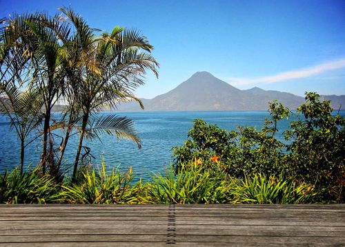
El Remate and around
On the eastern shore of Lago de Petén Itzá, the tranquil village of El Remate lies midway between Flores and Tikal, making it an easy, well-paced pause on 8-day Guatemala trips. The lake is a beautiful turquoise here and swimming is wonderful – an extremely welcome idea after a sweaty morning climbing jungle temples. It’s a lovely place to take a break from the rigours of the road, with little traffic and a lot of nature to enjoy, including the adjacent Biotopo Cerro Cahuí forest reserve.
There are several high-quality artisan workshops on the lakeshore that sell beautifully carved wooden handicrafts; stop by Artesanía Ecológical to see expert carver Rolando Soto at work.
The Mirador Basin
The remains of the first great cities of the Maya are still engulfed by the most extensive forests in the region, an area known as the Mirador Basin. The discoveries here in the extreme north of the country have already led to a complete rethink about the origins of the Maya, and it’s now clear that this was once the cradle of Maya civilization. The main focus of interest has been the giant site of El Mirador, the first Maya “superpower”, which is famous for its colossal triadic temple complexes. But neighbouring Nakbé, the first city to emerge (around 800 BC), Wakná (which was only discovered in 1998) and the massive ruins of Tintal (on the scale of Tikal) are just three of the myriad cities that once thrived in this now remotest of regions.
The conditions are very difficult – marshy mosquito-plagued terrain that becomes so saturated that excavations can only be attempted for five months of the year. Currently only around three thousand people make it to Mirador each year, and archeologists outnumber visitors at any one time. Numbers are tiny because of the effort or expense required to get to the ruins, which either involves days of hard hiking through dense jungle and swamps or a brief visit as part of a helicopter tour.
Access all areas
At the time of research local issues in Carmelita were creating problems for travellers wanting to enter the Mirador Basin. An association of guides, the Cooperativa Carmelita, was insisting that all tourists in the entire Basin region (including Nakbé and Tintal) have to be accompanied by guides from their group, paid at their official rates (from US$350/head). Tourists on a helicopter tour at Mirador, and hikers heading to Mirador from Uaxactún have also been charged or turned back. Legal challenges to this action were ongoing. For the latest news consult w elmiradorhike.blogspot.com.
El Mirador
El Mirador is perhaps the most exotic and mysterious Maya site of all. Encircled by the Petén and Campeche jungles, this massive city surpasses Tikal’s scale although we are only now beginning to piece together its history. Mayanists are not even certain of its name – el mirador means “the lookout” in Spanish – but it could have been Ox Te Tun (Birthplace of the Gods). Until the 1980s, it was assumed Mirador was a city from the Classic era, but this theory has been totally overthrown. We now know that Mirador was a Preclassic capital of unprecedented scale, and its fall around 150 AD was just the first of two catastrophic collapses suffered by the Maya civilization.
The ruins are surrounded by some of the densest tropical forests in the Americas, and you’re sure to encounter some spectacular wildlife, including the resident troops of howler and spider monkeys, toucans and perhaps even a scarlet macaw. Wildcat numbers in the area are some of the healthiest in Latin America, with an estimated four hundred jaguar, as well as ocelot, jaguarundi and puma.
Brief history
The latest research indicates that it was the boggy nature of the Mirador Basin that drew the first settlers here, the richness of its bajo mud allowing the early Maya to found villages based on crop cultivation. By 1000 BC (though some ceramic evidence suggests as far back as 1480 BC) these settlements were established and thriving at Mirador. The site chosen for the city itself was a commanding one, on an outcrop of karst (limestone) hills at an altitude of 250m, with swamps providing protection to the east.
By the Middle Preclassic, ceremonial structures were being built, including early temples at Los Monos, El Tigre and the Central Acropolis (generations later these structures would be built over and enlarged to a much grander scale). For centuries Mirador flourished, peaking between 350 BC and 100 AD, when it was home to over one hundred thousand Maya. The city’s ruling Kaan dynasty were overlords of hundreds of thousands more subjects in the Basin region and overlords of millions in the wider Maya World.
Mirador became a great trading centre as jade and obsidian were brought from the highlands; granite, shells and coral beads imported from the Caribbean and salt carried in from the Yucatán. The city grew to dominate the entire region, and by the time of Christ it must have been something to behold, its emblematic triadic temples painted scarlet with cinnabar and soaring high above the forest canopy, with a web of stone causeways connecting the great capital to dozens of other cities in its empire.
The hero twins panel
The Mirador Basin has no rivers (and had a population of hundreds of thousands in the late Preclassic) so the Maya developed extremely efficient water collection systems so that all available rainfall was channelled to huge reservoirs. In 2008, while investigating water channels in the Central Acropolis, archeologists discovered elaborately sculptured panels with scenes from the Maya creation story, the Popol Vuh. The two stucco panels, measuring 6m by 8m and still in situ, were carved about 200 BC and show the mythical hero twins swimming into the underworld to retrieve the decapitated head of their father. Dr Richard Hansen described it as like “like finding the Mona Lisa in the sewage system”.
The Mirador Basin under pressure
Undoubtedly the greatest challenge facing the archeologists and Guatemalan authorities is to save the Mirador Basin ruins from the constant threat of encroaching settlers, loggers, drug smugglers, cattle ranchers and tomb looters. Because of this lack of security, environmentalists and Mayanists are lobbying hard to get the entire Mirador region – 2169 square kilometres of jungle stretching from the Mexican border as far south as El Zotz – declared the Mirador Basin National Park. President Colom announced in his 2008 inaugural speech that the creation of a national park here was a priority, though this status was not achieved during his four-year tenure. An application is also registered with UNESCO to get Mirador declared a World Heritage Site.
Immediate and effective protection is essential. Successive Guatemalan governments have dithered while neighbouring reserves like Laguna del Tigre have gone up in smoke. Forty armed rangers patrol the Mirador area, otherwise, according to archeologist Dr Richard Hansen (who has led the excavations here for decades) “we’d lose the whole city”. Hansen sees strictly managed ecotourism, including the construction of a jungle lodge and narrow-gauge railway, as the way to preserve the forest and the dozens of Maya sites in the Mirador Basin. But his vision is not universally shared. Many settlers on the fringes, and inside the reserve, see little future in ecotourism and are lobbying for timber and farming concessions to be allowed. Occasionally these land-hungry campesinos torch a ranger station, and villagers at Dos Aguadas have even been granted a concession to farm inside the Maya Biosphere Reserve. So the choice seems to be fewer trees or more tourists.