El Oriente
The eastern highlands, often just called El Oriente, connect Guatemala City with El Salvador and Honduras and must rank as the least-visited part of the country. Virtually the entire population is ladino, and only a few elderly people, in a couple of isolated areas, still speak Poqomam Maya, the region’s indigenous language.
On 8-day Guatemala trips, El Oriente is usually a specialist addition rather than a first-choice route, best suited to travellers who already know the better-known highlands or want to understand a less visited side of the country. The ladinos of the east have a reputation for cowboy-like bravado, where quick tempers, warm hearts and displays of macho pride are all part of the region’s distinctive character.
The landscape lacks the immediate appeal of the western highlands – the peaks are lower and volcanoes here are heavily eroded. Close to the border with El Salvador the hills are incredibly fertile and the broad valleys lush with vegetation, but in the north of the area, around the key town of Chiquimula, the landscape is very different, with dry rounded hills and dusty fields. From this region it’s a short hop to the ruins of Copán in Honduras, while Esquipulas, with its famous basilica, and the lovely volcanic crater lake of Ipala are also close by. To get to the Oriente you branch off the Carretera al Atlántico at the Río Hondo junction, skirt Estanzuela, and head past Chiquimula and Esquipulas to the three-way border with Honduras and El Salvador.
Volcán de Ipala
About 20km south of Chiquimula, the Volcán de Ipala (1650m) may at first seem a little disappointing – it looks more like a hill than a grand volcano. However, the cone is filled by a beautiful little crater lake and ringed by dense sub-tropical forest. You can walk round the lake in an hour and it’s great for swimming or camping. From the trailhead, it’s a straightforward hour-and-a-half walk to the top, via a visitors’ centre.
The Motagua valley
Leaving Guatemala City, the main highway descends through a dry and distinctly inhospitable landscape with cacti spiking the barren hillsides. The first place of any note is the Río Hondo junction where the road divides: one arm heads south to the Oriente and town of Esquipulas, while the main branch continues on to the coast.
On down the valley the landscape starts to undergo a radical transformation; the flood plain opens out and there’s a profusion of tropical growth. It was this supremely rich flood plain that was chosen by both the Maya and the United Fruit Company, to the great benefit of both.
The ruins of Quiriguá
Sitting in an isolated pocket of rainforest, surrounded by an ocean of banana trees, the small archeological site of Quiriguá has some of the finest carvings in the entire Maya world. Only nearby Copán can match the magnificent stelae, altars and zoomorphs that are covered in well-preserved and superbly intricate glyphs and portraits.
The ruins are situated 68km beyond the junction at Río Hondo, and 4km from the main road, reached down a side road that serves the banana industry. Weather conditions are decidedly tropical. Indeed, cloudbursts are the rule and the buzz of mosquitoes is almost uninterrupted – bring repellent.
A brief history of Quiriguá
Quiriguá’s early history is still relatively unknown, but during the Late Preclassic period (250 BC–300 AD) migrants from the north established themselves as rulers here. In the Early Classic period (250–600 AD), the area was dominated by Copán, just 50km away, with Quiriguá no doubt valued for its position on the banks of the Río Motagua, an important trade route and as a source of jade. It was during the rule of the great leader Cauac Sky that Quiriguá challenged Copán, capturing its leader, Eighteen Rabbit, in 738 AD and beheading him, probably with the backing of the “superpower” city of Calakmul. Quiriguá was then able to assert its independence and embark on a building boom: most of the great stelae date from this period. For a century Quiriguá dominated the lower Motagua valley. Under Jade Sky, who took the throne in 790, Quiriguá reached its peak, with fifty years of extensive building work, including a radical reconstruction of the acropolis. Towards the end of Jade Sky’s rule, in the middle of the ninth century, the historical record fades out, as does the period of prosperity and power.
Quiriguá village
The village – also known as Quiriguá – is just off the highway, about 2km back towards Guatemala City. It’s a run-down sort of place, strung out along the railway track, but in the past it was famous for its hospital specializing in the treatment of tropical diseases, run by the United Fruit Company. This imposing building, which still stands on the hill above the track, is now a state-run workers’ medical centre; there’s a statue of Scottish doctor Neil Macphail (who ran the hospital here for forty years) in front of the structure.
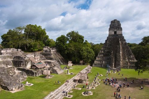
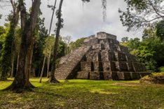
The ruins
Entering the site you emerge at the northern end of the Great Plaza. On the left is a badly ruined pyramid, directly ahead are the stelae for which Quiriguá is justly famous.
Stelae
The nine stelae in the plaza are the tallest in the Maya world and the quality of carving is remarkable. Similar in style in many ways to that of Copán, they feature portraits on the principal faces of the standing monuments and glyphs covering the sides. As for the figures, they represent the city’s rulers, with Cauac Sky depicted on no fewer than seven (A, C, D, E, F, H and J). Two unusual features are particularly clear: the vast headdresses, which dwarf the faces, and the beards. Many of the figures are shown clutching a ceremonial bar, the symbol of office. The glyphs, crammed into the remaining space, record dates and events during the reign of the relevant ruler.
Largest of the stelae is E, which rises to a height of 8m and weighs 65 tonnes. All the stelae are carved from a fine-grained sandstone. Fortunately for the sculptors the stone was soft once it had been cut, and fortunately for us it hardened with age.
Altars
Another feature that has helped Quiriguá earn its fame is the series of bizarre, altar-like zoomorphs: six blocks of stone carved with interlacing animal and human figures. Some, like the turtle, frog and jaguar, can be recognized with relative ease, while others are either too faded or too elaborate to be easily made out. The best of the lot is P, which shows a figure seated in a Buddha-like pose.
Ball court and Acropolis
At the southern end of the plaza, near the main zoomorphs, you can just make out the shape of a ball court hemmed in on three sides by viewing stands. The acropolis itself, the only structure of any real size that still stands, is bare of decoration. Trenches dug beneath it have shown that it was built on top of several previous versions, the earliest ones constructed out of rough river stones.
Museum
A small site museum has informative displays about the site’s historical significance and its geo-political role in Maya times as well as a diorama showing the extent of the ruins that remain unexcavated.
Fiestas in the Oriente and Izabal
Jan 12–15
El Progreso (near Jutiapa), main day 15th
Jan 15
Esquipulas, the biggest pilgrimage in Central America
Jan 20–26
Ipala, main day 23rd (includes bullfighting)
March 9
Esquipulas, a smaller day of pilgrimage to the Black Christ
March 12–15
Moyuta (near Jutiapa) and Olapa (near Chiquimula)
March (varies)
Jocotán
May 2–5
Jalapa, main day 3rd
May 5–9
Gualán (near Zacapa)
July 16–22
Puerto Barrios, main day 19th
July 22–26
Jocotán (near Chiquimula)
July 23–27
Esquipulas, a fiesta in honour of Santiago Apóstol, main day 25th
Aug 11–18
Chiquimula, main day 15th (includes bullfighting)
Aug 25
San Luís Jilotepéque
Nov 7–14
Sanarate
Nov 10–16
Jutiapa, main day 13th
Nov 26
Lívingston, Garífuna day here is a huge celebration
Dec 4–9
Zacapa, main day 8th
Dec 13–16
San Luís Jilotepéque
Dec 22–27
Cuilapa
Dec 24–31
Lívingston, carnival