Travel advice for Ecuador
From travel safety to visa requirements, discover the best tips for visiting Ecuador
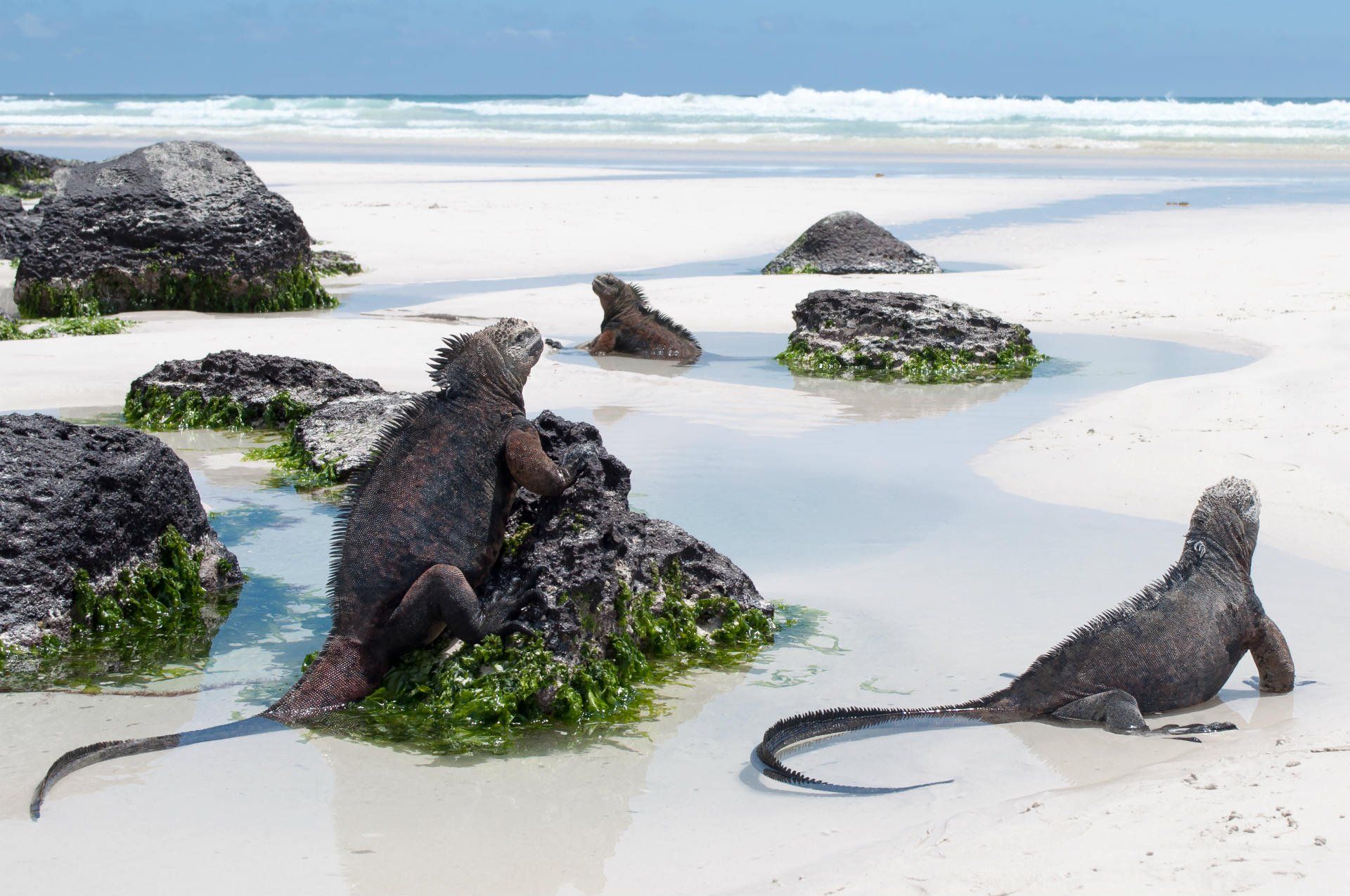
You can watch giant tortoises on the Galápagos, hike through misty cloud forests, and wander markets where local traditions are still strong. You might see birds with names you’ve never heard, taste local dishes in a busy market, or catch marine iguanas sunning themselves on volcanic rocks. Every part of Ecuador has something different to discover.
Planning ahead makes the trip smoother. A clear itinerary keeps travel manageable, whether you’re there for a few days or a couple of weeks. Rough Guides’ local experts can help you put it together and book what you need so you can focus on exploring. Here are our favorite Ecuador itineraries.
Most visitors to Ecuador pick a 7, 10, or 14-day itinerary, depending on how much of the country they want to see. The length of your trip affects whether you focus on a few highlights or cover a wider range of landscapes and cultures.

Tips from Maria José
Ecuador Travel Expert

When travelers ask me about Ecuador's hidden gems, I usually suggest spending at least one night in Baños. It’s not just about the famous swing at the end of the world. The thermal baths here have been a place to relax and heal since long before the Spanish arrived in the 1500s. Most tourists just pass through, but staying overnight gives you a chance to soak in the hot springs under the stars, which is a really special experience.
Not sure where to start? Our Ecuador travel experts can keep things simple.

How to plan a trip to Ecuador that's only a week long? This Ecuador itinerary is great for covering the country’s main landscapes. You’ll start in Quito, move through volcanic highlands, and reach the edges of the Amazon. The route passes cloud-covered mountains, valleys with rivers and waterfalls, and indigenous communities along the way.
The colonial district is compact and easy to explore on foot. Start at Plaza Grande where government buildings and churches line the square. Step inside La Compañía to see its gilded wood interior, then climb the towers of La Basílica del Voto Nacional for views over the city. Walk along La Ronda, under low balconies and past artisan workshops and cafés, to get a feel for daily life in Quito’s oldest street.
Insider tip: Pick up coca tea at a pharmacy to help with altitude adjustment.
The drive south is 155 miles (250 kilometers) along the Pan-American Highway. Traffic thins as you leave the city and climb into the highlands. Cotopaxi National Park is about 30 miles (50 kilometers) from Latacunga, roughly two hours from Quito.
Entering the park, the land opens into páramo grasslands dotted with small lakes. Lake Limpiopungo sits at 12,630 feet (3,850 meters), reflecting Cotopaxi’s snowcapped peak. Keep an eye out for wild horses, rabbits, and caracara birds as you walk short trails around the lake.
If you’re up for a hike, José Rivas Refuge sits at 15,750 feet (4,800 meters), about 1–2 hours along a trail that climbs gradually past volcanic rocks and thin air. On the way down, stop at Saquisilí market for fresh produce, woven goods, and pottery.
The drive continues downward, dropping nearly 6,560 feet (2,000 meters) into Baños.

The Waterfall Route follows the Pastaza River canyon for about 22 miles (35 kilometers) south of Baños. Roads wind past steep cliffs, and every turn opens onto a waterfall framed by cloud forest. At Manto de la Novia, a cable car crosses the canyon, letting you approach the falls from above. Trails at Pailón del Diablo lead to platforms where water crashes below your feet. Suspension bridges connect parts of the route.
Along the way, the forest grows dense, orchids and bromeliads cling to trunks, and hummingbirds flit through the canopy. Walking the route with stops at multiple falls takes 3–4 hours. The trail is damp and shaded, so be careful with footing.
Insider tip: Quick-dry clothing is best. Mist from waterfalls keeps you wet, even on sunny days.
Drive three hours back to Quito, leaving Baños in tropical morning light. From the airport, flights to Coca take about 30 minutes on small aircraft operated by TAME or Avianca.
At the Napo Cultural Center, the Kichwa Añangu community greets visitors with warm wayusa tea. Follow the Playas trail to see tanagers, poison dart frogs, and occasionally caimans in side channels. Sunset brings a gentle glow across ceiba-lined banks, and paddling quietly may reveal pink river dolphins surfacing nearby. The lodge is deep in Yasuní Biosphere Reserve, covering nearly 3,860 square miles (10,000 square kilometers), and the feeling of remoteness is immediate.
Insider tip: Apply insect repellent before the boat ride, mosquitoes are more active along the river.

Start early at the parrot clay lick. Hundreds of blue-headed and yellow-crowned parrots gather here for minerals. After breakfast back at the lodge, look for howler monkeys in the canopy or tapirs along the river.
At the Kuri Muyu interpretation center, you’ll learn about Kichwa traditions, from medicinal plants to hunting techniques. In the afternoon, hike through the forest to a 115 foot (35 meter) observation tower where toucans and sloths are visible in the emergent layer. Finish the day on a catamaran cruise along the river with local snacks while scanning for nocturnal animals.
Insider tip: Binoculars help because most animals are high in the trees.
Spend day 6 of this week long Ecuador itinerary exploring deeper guided forest trails. Your guide will explain how to identify medicinal plants, tracks wildlife, and shares traditional hunting knowledge. Morning activities might include piranha fishing or visiting a second clay lick where parakeets and macaws gather.
In the afternoon, visit the Añangu community to see pottery and weaving up close. At night, take a guided forest walk. Tarantulas, tree frogs, and nocturnal birds are active after dark, and the guide shows how to find creatures you would not notice in daylight.
Insider tip: Use a red filter on your headlamp to protect night vision and reduce insects.

Start the day on Añangu Stream, paddling through the blackwater creek while the canopy arches overhead. Look out for giant otters slipping along the water—they’re shy, but sometimes curious. In the afternoon, take the motorized canoe back to Coca. The river shifts as wildlife becomes more active, so keep an eye on the banks for parrots or monkeys moving through the trees.
From Coca, catch a roughly 30-minute flight to Quito and arrive by early afternoon. You’ll have time to wander Mercado Artesanal La Mariscal or grab a final lunch in La Floresta before heading home. This leg threads together the Andes, cloud forest, and lowland Amazon.
Make your itinerary work for you with help from our local experts.

This 10-day Ecuador itinerary takes you across San Cristóbal, Santa Cruz, and Isabela. You’ll get close to wildlife while still keeping travel easy. Giant tortoises graze, blue-footed boobies perform their dances, and marine iguanas warm themselves on lava rocks. Each day is paced so you can see the islands without feeling rushed.
When you land in Quito, head straight into the historic center. Start at Plaza Grande: you’ll see the Presidential Palace and the Cathedral right there. Then wander down La Ronda. There are workshops and cafés tucked in between the old buildings, and it’s fun just to peek in and see what people are making.
Altitude can hit hard—9,350 feet (2,850 m) isn’t nothing, so don’t overdo it. Just walking the streets and stopping for a potato soup (locro de papas) or an empanada de viento is plenty for day one.
Insider's tip: Bring small bills. Many Galapagos vendors can’t make change for notes over $20.
Travel time: 4 hours including airport transfers and flight
Early morning, fly to San Cristóbal via Guayaquil and make sure you have the transit control card for the Galapagos. Buses take you from the airport to Puerto Baquerizo Moreno. The Interpretation Center gives a clear introduction to the islands’ geology, wildlife, and conservation work.
Then hike 30 minutes up Tijeretas Hill for views over Darwin Bay. Frigatebirds circle above, sea lions lie along the shoreline, and marine iguanas warm themselves on volcanic rocks.
Insider's tip: Bring a dry bag. The snorkeling area at the base has clear water and tropical fish.

Travel time: 40 minutes boat ride
Catch a morning boat to Lobos Island, about 40 minutes from San Cristóbal. Boats are usually part of organized tours, and you might see dolphins along the way.
On the island, trails are clearly marked for visitors, and informational signs explain the local ecosystem. Blue-footed boobies perform mating dances on the rocks while Nazca boobies tend their chicks nearby. The bay is calm and clear enough for snorkeling, where sea lions swim close, and parrotfish and angelfish move through the coral.
Insider's tip: Use reef-safe sunscreen only. Chemicals in regular sunscreen damage marine life.
Travel time: 2.5 hours by speedboat
For day four of this Ecuador itinerary you’ll cross Puerto Ayora by boat. The ride can be choppy, so consider motion sickness medication if you’re sensitive. From the boat, it’s possible to spot manta rays or sea turtles near the surface. Once on Santa Cruz, head into the highlands where trails wind past working farms and giant tortoises wandering freely, some over 100 years old.
The Charles Darwin Research Station is open to visitors, with exhibits on breeding programs and land iguanas. Afternoon mists can make trails muddy, so a light rain jacket is useful. The day shows how conservation and daily life coexist.
Travel time: 2.5 hours by speedboat
In the morning of day five of this Ecuador itinerary, you can reach Puerto Villamil on Isabela in about 2.5 hours. Isabela is quieter than Santa Cruz, with sandy streets and a relaxed pace.
Flamingo Lagoon is nearby, where flamingos feed in shallow brackish water. The Giant Tortoise Breeding Station is open to visitors and focuses on subspecies from Isabela’s volcanoes. Short boat trips to Tintoreras islets let you see Humboldt penguins and white-tipped reef sharks in shallow channels. Snorkeling is another great activity and can bring you face to face with turtles, rays, and occasionally penguins.
Insider's tip: Isabela’s ATM often runs out. Bring enough cash from Santa Cruz for your stay.
Travel time: 45 mins drive
Start the day early with a drive through farmland to the trailhead for the Sierra Negra hike, which takes roughly 45 minutes from Puerto Villamil. The trail follows the caldera rim, about six miles (10 km) round-trip, and gives views over lava flows from the 2018 eruption, with smooth pahoehoe and rough aa textures. From the rim, you can see across Isabela toward Fernandina Island. Steam rises from fumaroles along the trail, reminding you the volcano is still active. The hike is manageable in a few hours if you start early, before clouds roll in.
Insider's tip: Start by 8am to finish before clouds block the views.
Travel time: 2.5 hours by speedboat
Speedboats depart Puerto Villamil in the afternoon for the roughly 2.5-hour ride back to Puerto Ayora. Wildlife sightings on the water vary depending on the time of day, sometimes including dolphins or rays. Once on Santa Cruz, there’s time to explore areas you may have missed.
The fish market is lively, with pelicans and sea lions near fishermen cleaning their catch. Along the waterfront promenade, marine iguanas move among visitors. A short visit to Las Grietas lets you see volcanic crevices filled with layers of salt and fresh water. The afternoon is also good for a quieter beach stop.
Insider's tip: Go to El Garrapatero Beach late in the afternoon. The crowds thin and giant tortoises sometimes appear from the vegetation.
Take a two-hour boat ride from Puerto Ayora to Floreana Island. The only settlement, Puerto Velasco Ibarra, has around 150 residents who maintain historic traditions, including the mail barrel post office once used by passing ships.
The island has a unique history, with stories of early settlers claiming baroness titles, disappearances, and alleged murders in the 1930s, which guides often share while showing connected sites. Beaches host green sea turtles, and Floreana mockingbirds, found only here, move confidently among visitors. The day is a mix of history, wildlife, and walking around the small community.

Travel time: 4 hours total including ferry, bus, and flight
Getting from Santa Cruz to Quito takes around four hours, including ferry, bus, and flight. Start with a short bus ride to the Itabaca Channel, cross on the ferry to Baltra Island, and take a shuttle to the airport. Plan at least three hours before your flight to allow for transfers. If you have time in the morning, stroll along Avenida Charles Darwin in Puerto Ayora, browsing for handmade jewelry with blue-footed booby designs or coffee from San Cristóbal. Flights usually connect through Guayaquil, arriving in Quito by early evening.
Travel time: 45 mins drive
If your flight is later in the morning, you can pick up last-minute items in Quito. Mercado Artesanal La Mariscal, near the airport, has Panama hats, alpaca garments, and colorful textiles. The drive to Mariscal Sucre International Airport takes about 45 minutes, though traffic can be unpredictable.
Turn your ideas into a trip with itineraries from our local experts.

This two-week Ecuador trip moves through the country’s varied landscapes, from colonial Quito to the Amazon rainforest, high volcanoes to indigenous markets. Fourteen days gives enough time to experience four distinct ecosystems at a comfortable pace. You can adjust to altitude changes and get a real feel for each environment along the Equator.
Quito sits high at 9,350 feet (2,850 m), so take it slow your first day. From Mariscal Sucre Airport, it’s about a 40-minute drive to the historic center. Start at Plaza Grande to see the Presidential Palace and the Cathedral, then wander La Ronda, a short street full of cafes and workshops. La Compañía has an interior covered in gold leaf, and La Basílica lets you climb towers for city views. Evenings are cool, so try a canelazo, a warm cinnamon drink.
Insider tip: Coca tea from any pharmacy helps with altitude headaches and fatigue.
Spend the morning walking Quito’s colonial center with a guide, then head to a historic house for a hands-on cooking experience. You’ll work with local ingredients, maybe making a simple potato soup or fresh ceviche, depending on what’s in season. In the afternoon, visit Mitad del Mundo, where the monument marks 0°0’0” latitude. The actual equator is a few hundred meters north at the Intiñan Museum, which has simple experiments with water and balancing eggs. Both sites include small cultural displays and a planetarium.

Travel time: 2 hours drive each way
On day three of this Ecuador itinerary, take a day trip to Otavalo. You can spend a few hours exploring the market, where Kichwa traders sell textiles, alpaca sweaters, and carved tagua nuts, and try street snacks like salted mango with chili, roast pork, or mote corn.
After the market, head to Cuicocha crater lagoon for a hike around the caldera, which takes around three to four hours at 10,500 ft (3,200 m). The trail moves through páramo grasslands with orchids and bromeliads, and you might spot Andean gulls or even spectacled bears. After the hike, return to Quito in the late afternoon.
Travel time: 2.5 hours on the Calacalí-La Independencia highway, descending from 9,350 feet in Quito to 4,100 feet in Mindo.
The drive from Quito to Mindo drops from 9,350 ft (2,850 m) to 4,100 ft (1,250 m) and passing Pichincha volcano along the way. In Mindo, you can start at the butterfly garden to see blue morphos and other species are most active in the morning. The nearby trails lead to waterfalls like Nambillo and Reina, and you can take a a tarabita cable car across the canopy. E

Travel time: 2.5 hours by road
Start the day on the Sendero de las Cascadas trails. Seven waterfalls dot the reserve, and Cascada Nambillo has a swimming hole if you want to cool off. Later, visit Yumbos or El Quetzal for a chocolate tour, tasting single-origin bars and learning how Ecuadorian cacao turns into chocolate.
Grab lunch in Mindo (trout and tilapia are widely served) before heading back to Quito. On the way back, Pululahua Geobotanical Reserve is worth a quick stop for photos of the inhabited volcanic crater. Buses run from Mindo or lodges can organize transfers.
Insider tip: Mindo’s blackberry wine and artisan chocolate make great gifts.
Travel time: 30-minute flight plus 2-hour boat ride.
You start the day with a quick flight from Quito to Coca, watching the Andes fade as the rainforest stretches out below.
At Coca, you meet your lodge’s motorized canoe for a roughly two-hour ride down the Napo River. The boat glides past stilted houses, small gardens, and fishing nets while macaws and kingfishers move overhead. Most lodges arrange the transfer once you’ve booked, so all you need is your flight info and to show up at the riverside dock.
Once at your lodge, a naturalist guide takes you on the Matapalo Trail, winding under giant ceiba and mahogany trees. You’ll see leaf-cutter ants at work and hear howler monkeys as night creatures begin to stir.

Start the day with birdsong and climb the 120-foot observation tower for sunrise over the canopy. Macaws, toucans, parrots, and eagles move between the trees as the forest wakes. Follow Tucaneta Trail to see medicinal plants like dragon’s blood trees and sangre de grado vines, plus orchids and bromeliads high in the canopy.
Charapa Trail leads to a blackwater lagoon where giant otters fish and hoatzins pick leaves. In the evening, glide along the river in a canoe, spotting caimans’ reflective eyes and listening to bats and tree frogs filling the night.
Insider tip: Long sleeves help keep tiny sweat bees from landing on skin, and are worth wearing even in hot weather.
Wake before dawn to watch hundreds of parrots gather at a clay lick. Scarlet macaws, blue-and-yellow macaws, and green parrots perch along the banks, eating mineral-rich clay that helps them digest fruit safely. Later, visit the Añangu Kichwa community. Learn how families fish with barbasco root and try chicha, a fermented yuca drink central to their social life.
In the afternoon, hike through terra firme forest beneath towering Brazil nut and kapok trees. Walking palms slowly shift toward sunlight while motmots and antbirds flit through the canopy, filling the forest with movement and sound.
Insider tip: Approach the clay lick from downstream to avoid startling the birds.

Spend day nine of this Ecuador itinerary moving through Mandi Forest, weaving between bamboo groves and aguaje palm swamps where macaws make their nests. Drift along flooded Igapo forest in a canoe, spotting three-toed sloths at eye level and anacondas draped across branches.
Garzacocha lagoon hosts monkeys of all sizes, from tiny pygmy marmosets to howlers calling from the canopy. As evening falls, take a slow walk through the undergrowth, watching tarantulas, camouflaged walking sticks, and listening to tree frogs fill the night. Guides highlight poisonous plants and insects and explain how each habitat supports different wildlife. Each trail highlights a new layer of rainforest ecology.
Insider tip: Spray pants and clothing with repellent and secure them at the ankles to avoid chigger bites.
Travel time: 2-hour boat ride plus 30-minute flight
Start day 10 of this two week Ecuador itinerary early with a canoe ride along the calm Napo River. Pink river dolphins surface nearby and hoatzins move clumsily through riverside vegetation. Birds call from the treetops, including herons, kingfishers, and parrots.
A short flight from Coca back to Quito traces the rainforest giving way to cloud forest and snow-capped peaks, with small farms scattered between rivers and hills. By afternoon, you have time to rest or wander Mariscal’s cafes and craft shops, easing back into the city’s thinner air after the humid jungle.
Insider tip: Wash Amazon clothes in hot water immediately to remove tiny seed ticks that cling to fabric.

Travel time: About 2 hours
The road south from Quito follows the Avenue of Volcanoes, with peaks rising on either side. Machachi valley rolls past, dotted with farms and known for its mineral water and cheese.
At Cotopaxi National Park, stop at Lake Limpiopungo. Walk around the lake at 12,800 feet (3,900 m), watching wild horses graze, spotting Andean foxes, and noticing chuquiragua flowers and cushion plants that cling to the high-altitude páramo. In the afternoon, continue up toward José Rivas refuge at 15,748 feet (4,800 m). The thin air makes each step heavier, but sweeping views of the central valley and surrounding volcanoes make it worth it.
Insider tip: Walking poles cost about $2 at the park entrance and help with balance on loose volcanic scree.
Travel time: About 2 hours to Quilotoa, then 2.5 hours to Baños.
On day 12 of this Ecuador itinerary, drive across the central highlands toward Quilotoa, a crater lake formed by a volcanic collapse around 600 years ago. The caldera stretches nearly two miles wide, and the rim trail shifts constantly with views of the green water 1,300 feet (400 m) below.
A steep descent takes about 30 minutes, and the climb back up roughly 90, though mules are available if you want a ride. From Quilotoa, continue to Baños de Agua Santa, winding down into subtropical valleys where sugarcane and tree tomatoes grow. Baños sits under active Tungurahua volcano, with thermal springs that give the town its name. The route passes indigenous communities where traditional dress is common.
Insider tip: Buy alpaca goods directly from vendors along the rim.

Travel time: About 2 hours to Chimborazo, then 1 hour to Riobamba
Start the day in Baños with the Waterfall Route, biking to Pailón del Diablo. Two viewing platforms give different perspectives of the cascade, and nearby, local melcocha makers stretch sugarcane taffy while shops display sweets like dulce de guayaba.
From there, drive toward Chimborazo, Ecuador’s highest peak at 20,549 feet (6,263 m). The landscape turns into barren páramo, with vicuñas grazing quietly. Stop at Carrel refuge at 15,744 feet (4,800 m), or continue hiking to 16,400 feet (5,000 m), the closest point to the sun on Earth thanks to the equatorial bulge. Finish the day in Riobamba, a colonial city framed by five volcanoes.
Travel time: Around 4 hours by road
For your last day, head south from Riobamba into Ecuador’s highlands. Near Palmira, sand dunes rise in a strange microclimate shaped by winds around Chimborazo. The road passes Ingapirca, Ecuador’s largest Inca ruins, where Cañari and Inca cultures merged. You can pause briefly to take in the structures from the roadside, or add more days to your itinerary to do it justice. From here, continue to Cuenca for your departure home.
Insider tip: Download offline maps for this leg, as cell service disappears in stretches between Riobamba and Cuenca.

No two travelers are the same. Everyone experiences Ecuador differently, and Rough Guides’ local experts know how to make your trip fit what you actually want to do. They can plan an itinerary that works for your interests and pace. You could focus on photographing wildlife, wandering local markets, trying adventure activities, or staying in comfortable accommodations.
Our experts handle all the details so you don’t have to worry about logistics. They can book boutique haciendas in the highlands, secure permits for Galápagos cruises, and arrange private naturalist guides. You can include experiences like cooking with local families, visiting Quito museums, or tracking wildlife in the Amazon. They’re also available throughout your trip to answer questions or help with unexpected changes.
If you want a trip that reflects your priorities, reach out for a free trip plan.

Ecuador packs a lot into a small space. Head to the Andes for volcanoes, local markets, and hiking trails, or dive into the Amazon for river trips and wildlife spotting. The coast has beaches and fishing towns, and the Galápagos Islands are perfect for up-close encounters with nature. Here are more Ecuador itineraries for inspiration
On this Ecuador itinerary, you’ll move through cities, highlands, and rainforest at a pace that works for families. Each day comes with cultural and natural experiences without feeling rushed.

This Ecuador itinerary focuses on Ecuador’s cloud forest region. You’ll spend your days on trails spotting birds and frogs, visiting farms, and exploring local markets.
This itinerary is great if you want to combine both countries. It moves from Ecuador’s varied landscapes into Peru’s historic sites. You’ll see wildlife in the Galapagos, explore the Andes, and finish at Machu Picchu.

Here are some of the most frequently asked questions and key points to help you make the most of your Ecuador itinerary..
You’ll want to plan for at least 10-14 days to get a good sense of the country. A week can cover Quito and either a quick Galápagos itinerary or a short Amazon stay. Two weeks allows time in Quito’s old town, Otavalo market, a 4-5 day Galápagos cruise or island hopping, and a 3-4 day Amazon lodge visit. Three weeks gives space for the Pacific coast near Montañita or some volcano climbs. Ecuador is small, so traveling between regions is usually straightforward, but each area deserves time to explore.
Ecuador is equatorial, so you can travel any time, but the best time to visit Ecuador will differ by region.
June to September tends to bring drier weather in the highlands and Amazon, with calmer seas in the Galápagos. December to May is warmer in the islands, though short afternoon showers are common. The coast is sunniest from December to April. The highlands are clearest June to September and December to January. The Amazon stays humid year-round, but rain is lighter August to November.

Buses connect most cities with regular, inexpensive service. Trips between Quito, Cuenca, and Guayaquil take 4-9 hours and are reasonably comfortable. Flights save time for distant destinations like Coca in the Amazon or the Galápagos.
Local buses and colectivos serve smaller towns, and taxis in cities are cheap. Rental cars are useful if you want flexibility in the highlands and are a lot more comfortable than the buses. The Tren Crucero runs scenic routes but is limited. Transfers for Amazon lodges and the Galápagos are usually included with your stay.
Flights to the islands leave from Quito or Guayaquil. Most people fly from Quito with a stop in Guayaquil. Daily flights go to Baltra near Santa Cruz and San Cristóbal. Total flight time with the stop is 3-4 hours. Airlines include Avianca, LATAM, and Equair. Book early, especially June to August and December to January. On arrival, pay the park entry fee ($200) and transit card ($20) in cash. From Baltra, a combination of shuttle, ferry, and bus takes you to Puerto Ayora on Santa Cruz in about 90 minutes.

Visiting both regions gives a clear view of Ecuador’s ecosystems. The Amazon has a lot of wildlife, including monkeys, caimans, and a wide range of birds, plus canopy walks and community visits.
The Pacific coast is different, with surfing around Montañita, whale watching June to September from Puerto López, beaches, and seafood. If time is limited, choose based on your interests. Both areas need 3-4 days to see much, so combining them works best for longer trips.
Quito is well located for highland excursions.
Backpackers can manage on $100 per day using hostels and buses. Mid-range travelers might spend $300 for hotels and meals. Luxury experiences exceed $600 daily. Major costs include Galápagos cruises ($1,500-5,000 for multi-day trips), Amazon lodges ($300-800 for 3-4 days), and park fees. Domestic flights cost $150-300 roundtrip. Meals at local eateries are $3-5, tourist restaurants $10-20. City buses cost under $0.50, intercity $5-15. Hostels start around $10-15, mid-range hotels $40-60.
Highland destinations require some preparation. Quito is 9,350 feet (2,850 meters), which can cause headaches, fatigue, or shortness of breath. Arrive 2-3 days before any strenuous activity. Drink plenty of water, avoid alcohol at first, and eat light meals. Diamox can be used preventively. Coca tea is widely available.
If you plan volcano climbs like Cotopaxi (19,347 feet / 5,897 meters) or Chimborazo (20,548 feet / 6,263 meters), spend a week acclimating with progressively higher hikes. Severe cases are rare in Quito. No altitude concerns exist at the coast or in the Amazon.
Riobamba is a convenient base for Chimborazo climbs, with local guides and altitude acclimatization at 9,022 feet (2,750 meters). Latacunga works well for Cotopaxi, about an hour from the park. Baños at 5,971 feet (1,820 meters) is suitable for Tungurahua when it is active.
For multiple climbs, staying in mountain refuges helps. Guides provide equipment, transport, and route advice. Climbing requires technical skills, proper gear, and careful acclimatization, so book with certified operators.
If you’d rather spend your time exploring than organizing, Rough Guides’ local travel experts are the answer. They’ll book everything, personalize your days, and stay available while you travel. Learn more about our tailor made trips.
From travel safety to visa requirements, discover the best tips for visiting Ecuador