The Kvarner Gulf Travel Guide

Squeezed between the Istrian peninsula to the north and Dalmatia to the south, the Kvarner Gulf brings together many of the Croatian coast’s most enticing features: grizzled coastal hills and mountains, an archipelago of ochre-grey islands, fishing villages with narrow alleys and gardens groaning under the weight of subtropical plants. The Kvarner island of Rab boasts sandy beaches of almost Caribbean proportions, and the range of rocky and pebbly coves on offer elsewhere will have Adriatic-beach enthusiasts scouring their brains in search of superlatives.

What to see in the Kvarner Gulf

Croatia’s largest port, Rijeka is a prosperous and cultured city brimming with hedonistic energy and a busy gateway to the islands that crowd the gulf to the south. Of these, Krk is the most accessible, connected to the mainland by a road bridge just half an hour’s drive from Rijeka; the islands farther out – Lošinj, Rab and Cres – are only accessible by ferry and have a correspondingly rural, laidback feel. Each has its fair share of historic towns, along with some gorgeous coves and beaches – especially the sandy ones at Baška on Krk and Lopar on Rab. Although lush and green on their western flanks, islands like Rab and Pag are hauntingly bare when seen from the mainland, the result of deforestation during the Venetian period, when local timber was used to feed the shipyards of Venice; the fierce northeasterly wind known as the bura has prevented anything from growing there again.

Back on the mainland, the Habsburg-era villas of Opatija and Lovran preserve an evocative flavour of the belle époque. The southern part of the Kvarner coastline is dominated by the stark and majestic Velebit mountains, a huge chain that comprises both the Northern Velebit and Paklenica national parks at opposite ends of the range.

Getting around the Kvarner Gulf

Getting around the region is straightforward: Rijeka is the hub of the transport system, with buses along the coast and ferries to the islands.

The Opatija Riviera

Just to the west of Rijeka, the Opatija Riviera (Opatijska rivijera) is a 20km stretch of sedate seaside resorts lining the western side of the Kvarner Gulf. Protected from strong winds by the ridge of Mount Učka, this stretch of coast became the favoured winter retreat of the Viennese upper classes in the years prior to World War I. At the centre of the Riviera is the town of Opatija, whose nineteenth-century popularity made it the Austro-Hungarian Empire’s answer to the Côte d’Azur. The Habsburg ambience survives in some attractive fin-de-siècle architecture, the best of which is in the dainty town of Lovran, just southwest of Opatija. There’s an abundance of good accommodation throughout the Riviera, although private rooms and pensions tend to be cheaper in Lovran than in Opatija.

Opatija

Longest established of the Kvarner Gulf resorts, Opatija is very much the grande dame of Croatian tourism. It was the kind of town that sucked in celebrities from all over Europe during the belle époque, an era that lives on in Opatija’s fine Austro-Hungarian buildings and neatly clipped parks. The resort continues to be patronized by Central Europeans of a certain age (there are times when you can walk the length of the seafront without seeing anyone under 45), although Opatija’s proximity to Rijeka ensures a regular influx of weekend trippers. Top-quality seafood restaurants have taken off in a big way in Opatija, especially in the fishing-village suburb of Volosko, turning the town into a major target for gastro-pilgrims.

The town is a long thin hillside settlement straddling along the base of Mount Učka. At its centre is the Slatina beach, a concrete lido surrounded by cafés and souvenir stalls. The main street, Maršala Tita, runs past some grand examples of fin-de-siècle architecture, although the seaside promenade of Šetalište Franza Jozefa offers far better exploring.

Brief history of Opatija

Opatija was little more than a fishing village until the 1844 arrival of businessman Iginio Scarpa, who built the opulent Villa Angiolina as a holiday home for his family and friends. In 1882 the villa was bought by Friedrich Schüller, head of Austria’s Southern Railways; having just built the line from Ljubljana to Rijeka, he decided to promote Opatija as a holiday destination and the town’s first hotels (including the Kvarner, Krönprinzessin Stephanie – today’s Imperial – and Palace-Bellevue) soon followed. Opatija quickly developed a Europe-wide reputation: Franz Josef of Austria met Kaiser Wilhelm II of Germany here in 1894, while playwright Anton Chekhov holidayed at the Kvarner in the same year. A decade later Isadora Duncan installed herself in a villa behind the Krönprinzessin Stephanie and was inspired by the palm tree outside her window to create one of her best-known dance movements – “that light fluttering of the arms, hands and fingers which has been so much abused by my imitators”.

Hiking on Mount Učka

Dominating the skyline above Opatija and Lovran is the long, forest-covered ridge of the Učka massif, which divides the Kvarner region from central Istria and is protected as a Nature Park. It is accessible by road from Rijeka via a route running over the northern shoulder of the mountain, which passes a turn-off to the 1396m summit of Vojak on the way. Rather than driving to Vojak, however, the best way to enjoy Učka’s wooded slopes is to walk. Paths are well marked, and the Učka map (25Kn), available from the tourist offices in Opatija and Lovran, is an invaluable guide.

Lovran is the starting point for the most direct hiking route up the mountain – the ascent takes around three and a half hours. A flight of rough-hewn steps begins immediately behind Lovran’s old centre, leading to the small Romanesque Chapel of St Rock on the edge of the village of Liganj. Join the road into Liganj for a couple of hundred metres, before heading uphill to the right through the hamlets of Dindići and Ivulići – semi-abandoned clusters of farmhouses and moss-covered dry-stone walls. From Ivulići it’s a steady two-hour ascent through oak and beech forest before you emerge onto a grassy saddle where an expansive panorama of inland Istria suddenly opens up, the peak of Vojak is another twenty minutes’ walk to the right. At the top, there’s an observation tower, TV mast and splendid views of Rijeka and the spindly form of Cres beyond. An alternative ascent, which takes about fifty minutes longer, starts just behind the Medveja campsite and ascends to the village of Lovranska Draga before climbing steeply up a wooded ravine to join the main path from Lovran.

From Vojak, a path descends north to Poklon (1hr), where you meet up with the old Rijeka–Istria road. There’s a terrace offering another view of the Kvarner Gulf here. On Sundays, bus #34 from Opatija climbs as far as Poklon once a day, making this a good starting point from which to tackle Vojak if time is short. From Poklon, you can work your way southeast back to Lovran (roughly a 2hr walk) by a downhill path which ultimately joins the main route you came up on.

Lovran

Lovran is an Italianate, green-shuttered little town with a small harbour, fringed by palatial belle époque villas sporting curly wrought-iron balustrades. Uphill from the harbour is an old quarter of vine-shaded alleys which converge on the fourteenth-century St George’s Church (Crkva svetog Jurja); the frescoes behind the main altar, which date from 1479, are reminiscent in style of the wall paintings at Beram and other Istrian churches. Opposite the church, the House of St George bears an eighteenth-century relief of the saint slaying a dragon above the doorway; it’s become something of a town trademark.

Lovran Chestnut Festival

The Lovran area is famous for its chestnut trees, which were originally imported from Japan in the seventeenth century. The chestnut harvest is celebrated by the Marunada Chestnut Festival, which takes place over three weekends in October: the first two weekends see festivities in hill villages above town, while the final weekend takes place in Lovran itself. The festival is used as an excuse for making a wide variety of cakes flavoured with chestnut purée, which are sold in all the local cafés.
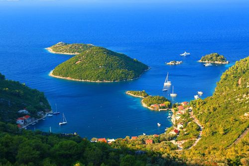
Cres and Lošinj

The westernmost of the Kvarner islands, Cres and Lošinj (really a single island divided by an artificial channel), together make up a narrow sliver of land which begins just south of the Istrian coast and extends most of the way across the Kvarner Gulf. Allegedly the place where Jason and the Argonauts fled with the Golden Fleece, the islands were originally known as the Absyrtides; according to legend, Medea killed her brother Absyrtus here and threw his remains into the sea, where two of his limbs became Cres and Lošinj.

Despite its proximity to the mainland, Cres (pronounced “tsress”) is by far the wilder and more unspoiled of the two islands, boasting a couple of attractively weather-beaten old settlements in Osor and Cres Town, as well as numerous villages and coves in which modern-day mass tourism has yet to make an impact. The island marks the transition between the lush green vegetation of northern Croatia and the bare karst of the Adriatic, with the deciduous forest and overgrown hedgerows of northern Cres – the so-called Tramuntana – giving way to the increasingly barren sheep-pastures of the south.

Lošinj (pronounced “losheen”) is smaller and more touristed than Cres, with a thick, woolly tree cover that comes as a relief after the obdurate grey-greenness of southern Cres. The island’s main town, Mali Lošinj, is a magnet for holiday-makers from Central Europe, though its harbour side Old Town relatively unsullied by mass tourism. Its near-neighbour Veli Lošinj, which lies within walking distance, is smaller and offers more in terms of fishing-village charm – although it too can get crowded in August.

Veli Lošinj

Despite the name (veli means “big”, mali “little”), Veli Lošinj is actually a smaller, quieter version of Mali Lošinj, the island's charming capital and port, a forty-minute walk along a scenic shoreline path via Valeškura Bay.

St Anthony’s Church

You can’t miss the hangar-like Baroque St Anthony’s Church (Crkva svetog Antuna), which contains a fine tempera-on-wood Madonna with Saints (above a side door on the left as you enter) painted by Bartolomeo Vivarini in 1475. Originally commissioned by the Venetian senate, the painting was paraded around Venice every year on the anniversary of the Battle of Lepanto to celebrate the famous naval victory over the Ottomans, until being bought by a Lošinj family shortly after the fall of the Venetian Republic.

Krk

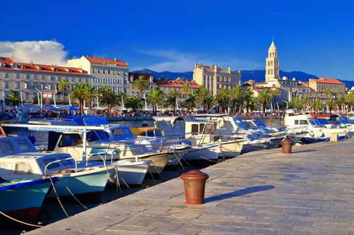
Joined to the mainland by a dramatically arcing bridge, Krk (pronounced “Kirk”, with a strongly rolled r) is the Adriatic’s largest island and also its most developed, a result of its proximity to Rijeka, whose airport is situated on the island. The main settlements are Krk Town, a historic little place with scraps of city wall surrounding a compact old centre; and Baška, a fishing village-cum-tourist resort with a spectacular sandy beach. Both of the above are heavily touristed, although there are plenty of quieter, quirkier places to explore – notably the wine-making centre Vrbnik.

Krk Town

The island’s main centre, Krk Town, centres on a small, partly walled city criss-crossed by narrow cobbled streets. Krk’s main bathing area lies to the east of town, where a sequence of small rocky coves provides a variety of atmospheric perches. There’s a naturist beach about twenty minutes’ walk east, by the Politin campsite.

Trg bana Jelačića and around

The main fulcrum of the town is Trg bana Jelačića, a large open space just outside the town walls to the west, looking out onto a busy little harbour. Watching over the southeastern corner of Trg bana Jelačića is a hexagonal guard tower of thirteenth-century vintage which, like many of Krk’s buildings, makes much use of Roman-era masonry. A Roman gravestone is positioned halfway up one wall of the tower, carved-relief portraits of the deceased peering down as if casually observing street life through an open window.

An opening on the eastern side of the square leads through to Vela placa, a smaller public space overlooked by another medieval guard tower, this time sporting a rare sixteenth-century 24-hour clock (noon is at the top, midnight at the bottom).

J.J. Strossmayera

Heading roughly east from Vela placa is the Old Town’s main thoroughfare, J.J. Strossmayera, a 2m-wide alleyway that becomes virtually impassable on summer nights, when the entire tourist population of the island seems to choose it as the venue for their evening corso.

Stara Baška

Stara Baška, 12km south of Punat, is a tiny place clinging to a narrow coastal strip beneath the sage-covered slopes of the 482m Veli Hlam – this would be the most beautiful spot on the island if it weren’t for the unsightly holiday homes. There are several small stretches of shingle beach, the best of which is in Oprna Bay 2km north of the village, visible from the road as you descend from the Punat direction.

Baška to Stara Baška on foot

It’s a three-hour walk across the mountains from Baška to Stara Baška. West from Jurandvor, a twenty-minute inland from Baška, a minor road leads to the hillside village of Batomalj, 1km away, the starting point for the path. The walk then rises steeply before skirting the 482-metre peak of Veli Hlam – it’s well maintained and marked in either direction, although the going can be very tough in wind, rain or hot sun. You will need to avail yourself of the invaluable hiking map provided free by Baška tourist office before setting out.

The Glagolitic script

The origins of Glagolitic go back to ninth-century monks Cyril and Methodius, dispatched by Central Europe by the Byzantine emperor to convert the Slavs to Christianity. In order to translate the Gospels into the Slav tongue, Cyril and Methodius developed a new alphabet better suited to its sounds than either Latin or Greek. They never made it to the Adriatic, but their followers subsequently disseminated the script among Croatian priests.

The script, which came to be known as Glagolitic (because so many manuscripts began with the words “U ono vrijeme glagolja Isus…” or “And then Jesus said…”) is an extremely decorative 38-letter alphabet which borrowed some shapes from Greek, Armenian and Georgian, but which also contained much that was original. Other disciples of Cyril and Methodius made their way to Bulgaria, where they produced a modified version of the script, called Cyrillic in recognition of one of their mentors, versions of which are still in use today throughout Eastern Europe.

The use of Glagolitic in Croatia was gradually edged out by the Roman alphabet.

Although it retains enormous symbolic and visual appeal – the characters look great on souvenir mugs and T-shirts. Aesthetic considerations aside, the number of Croats who could write their name in Glagolitic remains very small indeed.

Senj

Heading southeast from Rijeka takes you along one of the most exhilarating stretches of the Adriatic coast, with rocky highlands hovering above deeply indented bays, and bewitchingly stark grey-brown islands looming across the water. Long-standing beach resorts such as Crikvenica and Novi Vinodolski are pleasant enough to merit a brief stop-off, but insufficiently compelling to justify an overnight stay. Senj, a somewhat gritty little town of twisting alleyways, boasts an imposing fortress and is also a good base from which to explore the Northern Velebit National Park. The main focus of the town is Pavlinski trg, the harbourfront square, dotted with café tables, behind which lies a warren of alleyways and smaller piazzas.

The Uskoks

“May God preserve us from the hands of Senj.” So ran a popular Venetian saying, inspired by the warrior community known as the Uskoks, who in 1537 made Senj their home and used it as a base from which to attack Adriatic shipping.

The Uskoks started out as refugees from the Ottoman conquest of Bosnia, who gravitated towards the Adriatic and organized themselves into military groups in order to repel further Ottoman encroachment. Klis fortress was a major centre of Uskok activity until it fell to the Ottomans in 1537 – they subsequently withdrew to Austrian-controlled Senj, from where they mounted further resistance. Although regarded as a useful component in the Habsburg Empire’s defences, the Uskoks were consistently underpaid, forcing them to turn to piracy in order to survive. Harassing Adriatic shipping from their 15m-long rowing boats, they considered anything Ottoman a legitimate target, which in practice meant attacking the (usually Venetian) ships on which Ottoman goods were transported. The Austrians turned a blind eye, regarding Uskok piracy as a convenient way of challenging Venetian dominance of the Adriatic.

All this ultimately proved too much for the Venetians, who began a propaganda campaign accusing the Uskoks of eating the raw hearts of their enemies. In 1615 the Venetians provoked the so-called Uskok War with Austria in an attempt to bring an end to the problem. The Uskoks gave a good account of themselves until their Austrian protectors withdrew their support, and eager to make peace with Venice undertook to resettle the Uskoks inland. Senj was occupied by the Austrian navy, and the Uskoks left for new homes in Otočac, just to the southeast, or in the Žumberak hills north of Karlovac.

The Velebit

South from Senj, the Magistrala (main coastal road) picks its way beneath the rocky slopes of the Velebit, the mountain chain which follows the coast for some 100km. A stark, grey, unbroken wall, the Velebit is a forbidding sight when seen from the coast, although there are patches of green pasture and forest just below its string of summits. Two areas, Northern Velebit and Paklenica, have been designated as national parks. Offering some of the most exhilarating hiking in southeastern Europe, the Velebit can also be a dangerous place for the unprepared. Weather can be very unpredictable – it may seem sunny on the coast below, but a storm might be raging on the mountain once you reach a certain altitude. Avoid hiking alone, pick up weather forecasts from the relevant national park offices, and announce your arrival in advance if you’re planning to stay at any mountain shelters.

Northern Velebit National Park

Much of the Northern Velebit comes under the protection of the Velebit National Park (Nacijonalni park Sjeverni Velebit). Best starting point for excursions is Zavižan, the peak at the northern end of the park where there is a car park and a mountain hut. Travelling between the park and the Zagreb–Split autocesta will take you through the logging village of Krasno and the bear sanctuary at Kuterevo. Although just outside the boundaries of the park, one of the Northern Velebit’s most breathtaking features is Zavratnica cove, on the coast near the pretty harbour of Jablanac.

Easily reached from the nearby road’s-end car park, smooth-topped Zavižan (1676m) is the principal peak of the Northern Velebit and offers fantastic views of the Kvarner Gulf and its islands. Below the peak is the highest meteorological station in Croatia, which also functions as a mountain hut and serves basic refreshments. A ten-minute walk south of the car park is the Velebit Botanical Garden (Velebitski botanički vrt), with a circular trail leading round a meadow planted with herbs and flowers typical of these highlands.

The Premužić Trail

The Premužić Trail is a a 57km-long path mapped out by lifelong Velebit enthusiast Ante Premužić in the 1930s. Working its way from one side of the Velebit’s central ridge to the other, the trail provides a superb taste of the mountain’s varied geography, with lush deciduous woodland alternating with pine forests and arid rocky wastes. The trail was deliberately engineered to provide easy walking with gentle gradients – although the surface is stony and proper hiking boots are required. The easiest way to tackle it as a day-trip is to walk from Zavižan (1676m), the principal peak of the northern Velebit, to Rossijeva Koliba, an unmanned mountain refuge to the south (2hr 20min). From here you can return to Zavižan, or follow a trail downhill that meets the main coastal road near Starigrad, midway between Senj and Jablanac.

Paklenica National Park

The southern end of the Velebit massif culminates in a flourish of tortured limestone formations above the straggling seaside town of Starigrad Paklenica. It constitutes the obvious base for the Paklenica National Park (Nacionalni Park Paklenica), the most accessible hiking area in the southern Velebit. At the centre of the park are two limestone gorges, Velika Paklenica and, 5km to the south, Mala Paklenica (literally, Big Paklenica and Small Paklenica), which run down towards the sea, towered over by 400m-high cliffs. Velika Paklenica is a major tourist destination busy with hikers and rock-climbing enthusiasts from spring through to autumn, while Mala Paklenica has deliberately been left undeveloped in order to protect its status as a (relatively) untouched wilderness – paths are not well maintained and you’ll need good maps (available from local shops and the National Park office in Starigrad) if you want to explore.

The bura

One of the Kvarner Gulf’s most famous natural phenomena is the bura. A cold, dry northeasterly, it blows across the central European plain and gets bottled up behind the Adriatic mountains, escaping through the passes at places like Senj, where it is claimed to be at its worst. It’s said that you can tell the bura is coming when a streak of white cloud forms atop the Velebit. At its strongest, it can overturn cars and capsize boats. When it’s blowing, ferry crossings between the mainland and the islands are often suspended, and the road bridge to Krk as well as the road to Starigrad-Paklenica will either be off limits to high-sided vehicles, or closed altogether.

Rab

South of Krk and east of Cres, mainland-hugging Rab is the smallest but arguably the most beautiful of the main Kvarner Gulf islands. Its eastern side is rocky and harsh, rising to a stony grey spine that supports little more than a few goats, but the western side is lush and green, with a sharply indented coast and some beautiful coves. Medieval Rab Town is the island’s highlight, while the Lopar peninsula at the northern end of the island possesses some of the most glorious, sandiest beaches in the country. Rab is the jumping-off point for excursions to Goli otok, site of a notorious labour camp during the communist period.

Rab Town

A perfectly preserved, late medieval Adriatic settlement squeezed onto a slender peninsula, Rab Town is famous for the quartet of Romanesque campaniles that run along its Old Town’s central ridge. It’s a genuinely lovely place: a tiny grey-and-ochre city, enlivened with splashes of green palm, huddles of leaning junipers and sprigs of olive-coloured cacti which push their way up between balconied palaces. The population today is only a third of what it was in Rab’s fourteenth-century heyday, although it’s swelled significantly by the influx of summer visitors, who create a lively holiday atmosphere without overly compromising the town’s medieval character.

The Old Town divides into two parts: Kaldanac, the oldest quarter, at the end of the peninsula, and Varoš, which dates from between the fifteenth and seventeenth centuries. Together they make up a compact and easily explored grid of alleyways traversed by three parallel thoroughfares: Donja (Lower), Srednja (Middle) and Gornja (Upper) ulice.

Rab and the Royal tackle

Rab’s long-standing status as a naturist centre – the Frkanj peninsula just west of town was established as one of the first naturist resorts in Europe – was popularized by the visit of British King Edward VIII (accompanied by future wife Wallis Simpson) in the summer of 1936. Whether Edward actually got the royal tackle out or not remains the subject of much conjecture, but his stay on Rab provided the inspiration for a recent Croatian musical, Kralj je gol (literally “The King is Naked”, although in colloquial Croatian it means much the same thing as the expression “The Emperor’s New Clothes”). After visiting Rab, Edward and Wallis continued down the Adriatic aboard a luxury yacht packed with sundry toffs and royal hangers-on. Pursued by Europe’s press, the trip turned into the celebrity media-fest of its day, with thousands of locals lining the streets to ogle the couple when they came ashore at Šibenik, Split and Dubrovnik. The only journalists who failed to follow the cruise were the British – the idea that their monarch was romancing an American divorcee was too mind-bogglingly scandalous to report.

Rabska torta

Widely available in local shops and cafes, Rab’s deliciously sweet rabska torta (“Rab cake”) is really more of a pie than a cake, consisting of marzipan wrapped in sugary dough that is part pastry, part biscuit. Vilma and Kiflić are the main local producers and their recipes are rather different – thereby providing you with a perfect excuse to try them both.

The Rapska fjera

Rab’s biggest annual event is the Rapska fjera festival, a three-day gala comprising St James’s Day (July 25), St Anne’s Day (July 26) and St Christopher’s Day (July 27). Taking a traditional fourteenth-century holiday as its cue, the town literally reverts to the Middle Ages – six hundred participants don home-made costumes to recreate the olden times with games, dances, traditional cooking and other cultural events. Street stalls, processions, knightly tournaments and crossbow competitions are the cornerstones of the programme, and with thousands of visitors pouring into town to celebrate, there’s no more invigorating time to be on the island.

The Lopar peninsula

The road that climbs out of Rab to the north makes its way down the island’s broad central valley. After passing the sprawling settlement of Supetarska Draga, the main road reaches a T-junction at the neck of the Lopar peninsula. The left turn leads to the village of LOPAR, a handful of houses spread around a muddy bay. The right turn leads to San Marino, 1km south.

San Marino is a largely modern village which nevertheless lays claim to being the birthplace of St Marin, a fourth-century stonemason who fled persecution by crossing the seas to Italy, founding the town that subsequently became the republic of San Marino.

San Marino stretches around a vast expanse of sand known as Veli mel (mel being an archaic word for “beach”, although it’s also referred to hereabouts as Rajska plaža – “Paradise Beach”), backed by cafés and restaurants and packed with families from June to September. The bay on which Veli mel is situated is unusually shallow, and you can paddle almost all the way to an islet about 500m offshore.

There’s a sequence of smaller, progressively less crowded, sandy beaches beyond the headlands to the north, beginning with Livačina Bay, followed by the predominantly naturist Kaštelina Bay slightly further up.

Goli otok

Immediately to the east of the Lopar peninsula is Goli otok (Bare Island), a hummock of arid rock that was used to imprison communists who remained loyal to the Soviet Union after Stalin’s break with Tito in 1948. Over a period of five years, a total of fifteen thousand alleged Stalinists were “re-educated” on Goli otok through forced labour. Few of the prisoners were guilty of seriously plotting against the regime; the majority were minor figures who had simply spoken out against Tito in private and been betrayed by a colleague or friend. Inmates were subjected to a harsh regime of beatings and torture; recalcitrant prisoners had their heads immersed in buckets of human excrement, while those who confessed their ideological errors were recruited to torture the others.

From the mid-1950s onwards, Goli was used to incarcerate common criminals, and the prison regime was softened. Sent here as an army deserter, Romany singing legend Šaban Bajramović (1936–2008) played in goal for the prison football team and performed in the prison orchestra, going on to become a pan-Yugoslav musical superstar after his release.

Around the island

Boats arrive at a port area where the camp’s administrative buildings were based. Nowadays there’s a simple konoba beside the harbour, and a tourist train (the driver doesn’t turn up every day) that trundles round the island. Uphill from the port lies a row of derelict workshops where inmates were set to work sawing the timber shipped over from the mainland. Above the factory zone is a central plateau covered in scrub, and a couple of spartan-looking accommodation blocks and solitary cells. English-language information boards will give you some idea of what went on here. Paths descend to another port area on the eastern side of the island, where most prisoners arrived and departed. It takes about ninety minutes to tour the whole circuit, and temperatures can be scorching in summer; bring appropriate headgear and water.

Pag

Seen from the mainland, Pag is a desolate pumice-stone of an island that looks as if it could barely support any form of life. Around eight thousand people live here, looking after three times as many sheep, who scour the stony slopes in search of edible plant life. Much of their diet comes from sage, which covers the eastern side of the island with a grey-green carpet. The two main settlements are Pag Town, with an attractive historic centre, and Novalja, a buzzing modern settlement whose nearby Zrće beach is arguably the prime venue for Adriatic clubbing. Roaming further afield, the sleepy Lun peninsula is famous for its ancient olive groves, while the inland village of Kolan is the place to buy a hunk or two of the island’s famous cheese.

Pag cheese

Pag’s main culinary claim to fame is a hard, piquant sheep’s cheese (paški sir), which has a taste somewhere between mature cheddar and Parmesan; you’ll find it in supermarkets all over the country. The distinctive taste is due to the method of preparation – the cheeses are rubbed with a mixture of olive oil and ash before being left to mature – and the diet of the sheep, which includes many wild herbs (notably the ubiquitous sage) flavoured by salt picked up from the sea by the wind and deposited on vegetation across the island.

Top image: Rab © Marcelino Macone/Shutterstock

Discover more places in Croatia

Planning your own trip? Prepare for your trip

Use Rough Guides' trusted partners for great rates

Rough Guides Editors

written by Rough Guides Editors

updated 26.04.2021

Ready to travel and discover
Croatia?

Get support from our local experts for
stress-free planning & worry-free travels

Plan my trip ⤍