San Carlos
Perched on the northern slopes of the Cordillera Central, 650m above sea level, San Carlos (also known as Ciudad Quesada, or simply Quesada) has a decidedly rural atmosphere – fresh produce overflows from market stalls onto the streets, and campesinos with weathered faces hang out in the main square in front of the church. You’re likely to pass through here on the way from or to La Fortuna; there’s little to actually do – locals only come into town to have a drink on Friday night or to sell their wares at the Saturday market – though therein lies its charm. Strolling about town, you get a real feel for what drives Costa Rica’s economy: much of the nation’s milk, beef, citrus fruit and rice come from the large-scale agricultural holdings in these parts. Positioned at the heart of cattle country, San Carlos is also something of a saddlery centre; it’s well worth dropping by one of the expert saddlers, if only to watch them skillfully working the supple leather.
The Far North
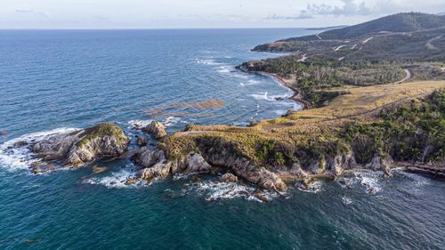
The far north of the Zona Norte is an isolated region, culturally as well as geographically, closer in spirit to Nicaragua than to the rest of the country and mostly devoted to sugar cane, oranges and cattle. Years of conflict during the Nicaraguan civil war made the region more familiar with CIA men and arms-runners than with tourists, but it’s all quiet now.
Most visitors are here to see the Refugio Nacional de Vida Silvestre Caño Negro, a vast wetland that makes up one of the most remote wildlife refuges in the country. Located at a key point on the migratory route between North and South America, it acts as the resting place for hundreds of migrant bird species and is considered by the Ramsar Convention on Wetlands to be the third most important wetland reserve in the world.
Caño Negro is accessed from Los Chiles, near the Nicaraguan border, and the only village of any size in the far north. The drive up here, along an unnervingly straight stretch of road from San Carlos, takes you through a flat landscape of rust-red soil and open pasture, broken only by roadside shacks, with the Llanura de Guatusos stretching hot and interminably to the west. During the Nicaraguan civil war, Los Chiles was a Contra supply line. Nowadays, there’s a climate of international cooperation, helped by the fact that many of the residents are of Nicaraguan extraction, and crossing the border is straightforward, as long as your documents are in order. Incidentally, the Río San Juan is technically Nicaraguan territory – the border is on the Costa Rican bank – though Costa Rica is allowed free use of the river.
Los Chiles
The only reason tourists make it to Los Chiles, a border settlement just 3km from the Nicaraguan frontier, is to break their journey on the way to Caño Negro, 25km downstream on the Río Frío, or to cross the Nicaraguan border – although the majority of travellers still cross at Peñas Blancas, further west on the Interamericana. There’s little to do in town other than soak up its end-of-the-world atmosphere – the highway peters out just beyond Los Chiles in the direction of the Río San Juan, leaving nowhere to go but the river – though you can while away some time wandering down to the docks, where the tumbledown houses evoke a forlorn, France-in-the-tropics feel.
Refugio Nacional de Vida Silvestre Caño Negro
The largely pristine Refugio Nacional de Vida Silvestre Caño Negro, 25km southwest of Los Chiles, is one of the places in the Americas to view enormous concentrations of both migratory and indigenous birds, along with mammalian and reptilian river wildlife. Until recently, its isolation kept it well off the beaten tourist track, though access has improved and nowadays numerous tours are offered from San José, La Fortuna and – best of all – the adjacent village of Caño Negro.
The refuge is created by the seasonal flooding of the Río Frío, so depending on the time of year you may find yourself whizzing around a huge 800-hectare lagoon in a motorboat or walking along mud-caked riverbeds. There’s a 3m difference in the water level between the rainy season (May–Nov), when Caño Negro is at its fullest, and the dry season (Dec–April); while the mammalian population of the area stays more or less constant, the birds vary widely. The best time to visit is between January and March, when the most migratory species are in residence and you’ll see scores of caiman basking on the riverbanks.
Watching wildlife in Caño Negro
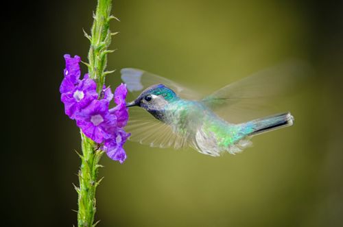
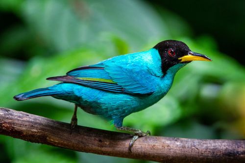
The wildlife that calls Caño Negro home includes a staggering variety of birds such as storks, cormorants, kingfishers and egrets. You should be able to tick off a number of the heron species that inhabit the riverbanks (including green, boat-billed and rufescent tiger herons), along with northern jacana and purple gallinule. The lagoon itself is a good place to spot the elegant, long-limbed white ibis; its shimmering dark-green cousin, the glossy ibis; and perhaps the most striking of all the reserve’s avifauna, the roseatte spoonbill, a pastel-pink bird that is usually seen filtering the water with its distinctive flattened beak. The most common species are the sinuous-necked anhingas (snakebirds), who impale their prey with the knife-point of their beaks before swallowing, though Caño Negro is also home to Costa Rica’s only colony of Nicaraguan grackle.
Reptiles are abundant, particularly the large caiman that lounge along the river and on the fringes of the lagoon, though you’ll also spot plenty of pot-bellied iguanas. Look out, too, for the strikingly green emerald basilik lizard; swimming snakes, heads held aloft like periscopes, bodies whipping out behind; and the various turtles (yellow, river and sliding) that can be seen resting on logs at the water’s edge.
Large mammals that live in Caño Negro include pumas, jaguars and tapirs, but these private creatures are rarely spotted. Howler monkeys are at least heard if not seen – it helps to have binoculars to distinguish their black hairy shapes from the surrounding leaves in the riverside trees – though it takes a good guide to pick out a sloth, camouflaged by the green algae often covering their brown hair. The rows of small grey triangles you might see on tree trunks are bats, literally hanging out during the day.
Perhaps the reserve‘s most unusual inhabitant (in the wet season, at least) is the tropical garfish, a kind of in-between creature straddling fish and reptile. This so-called living fossil is a fish with lungs, gills and a nose, and looks oddest while it sleeps, drifting along in the water.
The Sarapiquí Region
Costa Rica’s Sarapiquí region stretches around the top of Parque Nacional Braulio Carrillo and west to the village of San Miguel, from where Volcán Arenal and the western lowlands are easily accessible by road. Tropical and carpeted with fruit plantations, the area bears more resemblance to the hot and dense Caribbean lowlands than the plains of the north and, despite large-scale deforestation, still shelters some of the best-preserved premontane rainforest in the country. The Sarapiqui region is made up of three districts; La Virgen, Horquetas and Puerto Viejo.
Thanks to the Sarapiquí River providing fertile land, the region is a massive export of bananas, coffee, cardamom and cacao.
Things to do in the Sarapiquí Region
The largest settlement in the area, the sleepy capital of Puerto Viejo de Sarapiquí, attracts few visitors and is primarily a river transport hub and a place for the plantation workers to stock up on supplies, though it can make a good base for exploring the superb Estación Biológica La Selva. The region’s chief tourist attractions, however, are the rainforest lodges of Rara Avis and Selva Verde, which offer access to some of the last primary rainforest in Costa Rica.
Best times to visit the Sarapiquí Region
Unsurprisingly, the region receives a lot of rain – as much as 4500mm annually, and there is no real dry season (although less rain is recorded Jan–May), so rain gear is essential. The rain helps create a variety of white-water thrills for kayakers and rafters who flock to the area around La Virgen for runs on the Río Sarapiquí. The best time to visit is during December and April.
The outdoor turnos festival, where there are fairs, bull-riding and livestock/cattle shows, happens frequently throughout the year - so chances are you will experience the wonder of the agricultural festivals whenever you plan to visit.
Getting to the Sarapiquí Region
Until the road via Vara Blanca is repaired following the Cinchona Earthquake, the only route from San José or the Valle Central is via the Guápiles Highway through Parque Nacional Braulio Carrillo, heading left at the Las Horquetas/Puerto Viejo de Sarapiquí turn-off at the base of the mountain pass. There are no domestic airports nearby, so a car is your main option, along with private/shuttle transfers. The ride is around 2 hours from San Jose.
Estación Biológica La Selva
The fully equipped research station of Estación Biológica La Selva, 4km southwest of Puerto Viejo de Sarapiquí, is one of the best birdwatching destinations in the Sarapiquí, if not the country. You can spot over half of Costa Rica’s bird species here (489 in total), including the red-capped manakin – La Selva is a regular port of call for documentary makers looking to capture their energetic mating displays. An equally staggering number of tree species (some 350) have been identified, as well as 113 species of mammals, including anteaters, sloths (both two- and three-toed) and monkeys. Leading biologists from around the world have studied here, and its facilities are extensive: a large swath of premontane rainforest shouldering the northern part of Parque Nacional Braulio Carrillo forms the natural laboratory, while the research facilities include lecture halls and accommodation for scientists and students.
Fruits of their labour
Despite harbouring some of the largest remaining tracts of primary rainforest in the country, the Sarapiquí region is also home to a frightening number of banana and pineapple farms, while south of Puerto Viejo de Sarapiquí, the land around the small town of Las Horquetas is the site of the biggest palmito (heart-of-palm) plantations in the world. As in the rest of Costa Rica, it’s a difficult balance between preserving the rainforest (land rendered useless by monobiotic methods employed in the cultivation of pineapples, for example, can take up to fifty years to recover), and appeasing the needs of the local workers – palmitos, bananas and pineapples form the core of the regional economy.
For a closer look into the everyday lives of these workers (many of them Nicaraguan migrants) you can take a tour of the Dole banana plantation at Finca Zurqui, 5km southeast of Puerto Viejo de Sarapiquí.
The great green macaw: back from the Brink?
The Sarapiquí region harbours the country’s last flocks of great green macaw (lapaverde), the largest parrot in Central America. Globally endangered, it is estimated that less than 200 birds remain in Costa Rica, with fewer than 30 breeding pairs, but the fact that they survive here at all – in what constitutes just ten percent of their original home range – is only due to some sterling conservation work. Continued deforestation across the Zona Norte has caused a dramatic decrease in the population of the great green macaws, whose unfortunate fate is to rely on the almendro tree (a popular tropical hardwood) for their existence, nesting in its boughs and feeding on the large nuts it produces.
Suan Juan-La Selva Biological Corridor
The almendro is now, belatedly, protected, but the first major step in the fight to save this beautiful bird was the creation of the San Juan–La Selva Biological Corridor, which ecologically links the Reserva Biológica Indio-Maíz in Nicaragua with the Cordillera Central – great green macaws require a wide area for breeding and foraging, and the corridor acts as a vital migratory pathway. Its conservational focus is the Refugio Nacional de Vida Silvestre Mixto Maquenque, a multi-use wildlife refuge encompassing more than 500 square kilometres of wetlands, lagoons and lowland Atlantic forest that was established in 2005, after ten years of hard lobbying.
Costa Rican Bird Route
Mixto Maquenque plays a vital role in sustaining Costa Rica’s great green macaw population, though the bird’s future depends as much on the continuity of the corridor, which can only really be achieved through the creation of private eco-reserves that provide a financial incentive for conserving their habitat. The first of these initiatives, the Costa Rican Bird Route – which includes Reserva Biológica Tirimbina, Selva Verde Lodge and Estación Biológica La Selva – was set up to improve bird tourism in the region, thus delivering greater economic opportunities to local communities. The development of the Bird Route has resulted in another fifteen square kilometres of forest being newly protected as official private reserves.
Reserva Rara Avis
Remote Reserva Rara Avis, 17km south of Puerto Viejo and about 80km northeast of San José, offers one of the most thrilling and authentic ecotourism experiences in Costa Rica. Bordering the northeastern tip of pristine Parque Nacional Braulio Carrillo, the reserve features both primary rainforest and some secondary cover dating from about 35 years ago and boasts an incredibly diverse rainforest flora. The area is home to a number of unique palm species, including the stained-glass palm tree, a rare specimen much in demand for its ornamental beauty, and the walking palm, whose tentacle-like roots can propel it over a metre of ground in its lifetime as it “walks” in search of sunlight. Orchids are also numerous, as are non-flowering bromeliads, heliconias, huge ancient hardwood trees smothered by lianas, primitive ferns and other plants typically associated with dense rainforest cover.
Established in 1983 by American Amos Bien (a former administrator of the Estación Biológica La Selva), forest ranger Robert Villalobos and biologist Carlos Gómez, Rara Avis combines the functions of a tourist lodge and a private rainforest reserve, and is dedicated to both the conservation and farming of the area. A pioneer in the country’s ecotourism movement, its ultimate objective is to show that the rainforest can be profitable, giving local smallholders a viable alternative to clearing the land for cattle. Rara Avis supports a number of endemic plants that have considerable economic potential, including geonoma epetiolata, or the stained-glass palm, which was until recently believed to be extinct. Another significant part of the reserve’s mandate is to provide alternative sources of employment in nearby Las Horquetas, where most people work for the big fruit companies or as day-labourers on local farms.
Rara Avis also functions as a research station, accommodating student groups and volunteers whose aims include development of rainforest products – orchids, palms and so forth – as crops, as well as the silk of the golden orb spider.
Watching wildlife at Rara Avis
A mind-boggling number of bird species have been identified at Rara Avis, and it’s likely that more are yet to be discovered. As well as the fearsome black, turkey and king vultures and the majestic osprey, you might see nine species of parrot, over twenty types of antbird, thirty different species of hummingbird, both chestnut-mandibled and keel-billed toucans, and the unlikely named great potoo. The endangered great green macaw also nests here, and trogons, bare-necked umbrellabirds and the distinctive-looking three-wattled bellbird can also be spotted.
Among the more common mammals are opossums, monkeys, armadillos, anteaters, sloths and bats (eleven species in total). The reserve harbours five of the country’s six cat species, though the closest you’ll probably come to an ocelot or jaguar is discovering their tracks on a muddy trail. You may also encounter the Watson’s climbing rat that frequents the Waterfall Lodge and has a voracious appetite for hand soap.
Amphibians and reptiles are abundant, ranging from the tree-climbing salamander to the white-lipped mud turtle, and including eight species of tree frog alone. Along with other vipers, the fer-de-lance and bushmaster snakes, two of the most venomous in the world, may lie in wait, so take extra care on the trails by looking everywhere you step and put your hand. Boa constrictors also hang out here; if you do see one, be careful as the generally torpid boa can get aggressive when bothered.
Selva Verde Lodge
One of the most luxurious rainforest lodges in Costa Rica and a paradise for birdwatchers, Selva Verde Lodge sits aside two square kilometres of preserved primary rainforest alongside the Río Sarapiquí. The lodge comprises an impressive complex of accommodation blocks, dining hall, lecture rooms and a lovely riverside restaurant-bar where monkeys chatter above and the Sarapiquí bubbles below. It’s set in tropical gardens rather than dense overgrowth, though the vegetation around the lodge is still home to toucans, sloths and howler monkeys, while iguanas and basilisk lizards are frequent poolside visitors. Wilder, primary rainforest stretches off into the distance the other side of the river, accessed on a guided tour, and provides habitat for one of the region’s most endangered species, the great green macaw.
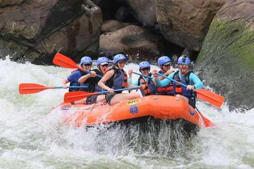
White-water thrills: the Puerto Viejo and the Sarapiquí
The wild Río Pacuaré near Turrialba may lure adrenaline junkies to Costa Rica, but the churning waters around La Virgen have plenty of thrilling white-water action on offer. The relaxing Class I–II run that puts in on the Río Puerto Viejo is essentially a scenic float along a jungle-lined river, suitable for wildlife-watchers and small children (from 3). Moving up a grade, the Class III runs, which start on the Río Sarapiquí around La Virgen, require good physical fitness but can be ridden by anyone over 8. If you want to tackle the ferocious and technically more demanding Class IV runs on the Upper Sarapiquí, you must be over 16 and have plenty of experience wielding a paddle.
Top image: Costa Rica, eco lodge in the rainforest © ronnybas frimages/Shutterstock