Planning your own trip? Prepare for your trip
Use Rough Guides' trusted partners for great rates
written by
Rough Guides Editors
At the bottom end of the South American continent, and split between Chile and Argentina, Tierra del Fuego (“Land of Fire”) holds nearly as much fascination for travellers as Patagonia, from which it is separated by the Magellan Strait. In fact, it was Magellan who dreamed up the dramatic and somewhat unlikely name, after sighting dozens of fires lit by the native Yámana. Though comprising a number islands, it’s more or less the sum of its most developed part, the Isla Grande, the biggest island in South America. Argentina possesses the easternmost half of Isla Grande, plus Isla de los Estados (Staten Island) and a smattering of tiny islets to the south; the rest is Chilean territory.
On the Chilean side, you’ll find the isolated main town of Porvenir, which huddles on the Magellan Strait. Flat plains cover much of northern and central Isla Grande, but further south, the countryside becomes less barren, with thick woodland and crystalline rivers near little Camerón stretching southeast towards a number of exquisite lakes, including Lago Blanco, and the densely forested 2000m peaks of the Cordillera Darwin in the far south. South of Isla Grande, across the Beagle Channel, lies Isla Navarino, home to the tiny Puerto Williams, the southernmost permanently inhabited settlement in the world, plus one of the most challenging hiking trails in South America, the Los Dientes Circuit. Beyond Navarino is Cabo de Hornos (Cape Horn), the land’s end of the Americas, accessible only by sea or air.
In the Argentine sector, the leading attraction is the city of Ushuaia on the south coast of Argentine Tierra del Fuego. It is the base for visiting the Beagle Channel, rich in marine wildlife, the lakes, forests and tundra of nearby Parque Nacional Tierra del Fuego, the historic Estancia Harberton, and, of course, Antarctica. It is also Tierra del Fuego’s main tourist destination, with winter skiing and summer trekking high on the list of activities. Also in Argentine Tierra del Fuego, you’ll find the scenic Lago Fagnano; from the lake to the 2985m Paso Garibaldi, the gateway to Ushuaia by road, you’ll travel through patches of low, transitional, lichen-festooned Fuegian woodland.
Fly or sail to Puerto Williams, the world’s southernmost town, and – if you have the stamina – tackle one of the toughest hiking circuits in South America, the Dientes de Navarino.
Sailing around the tip of South America in a ship or viewing its harsh beauty from the air is a memorable experience.
Spot sea lions and penguins, cormorants and albatrosses, and maybe even killer whales, while enjoying spectacular mountain views.
Zip down the slopes of this winter sports resort, dramatically located at the end of the world, or go sledging with huskies.
Explore this fascinating and little-visited chunk of jagged mountains, beech forest, bogs, tundra and beautiful coast on foot.
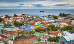
A collection of brightly painted corrugated iron houses set in a narrow bay of the same name, Porvenir (optimistically meaning “future”) gives off the impression of order stamped on nature, with neat topiary leading down the main street, Philippi, from an immaculate Plaza de Armas, overflowing with native vegetation. The seafront Parque del Recuerdo sports a curve of flagpoles, the painted skeleton of a steam engine, the mounted stern of a boat and a statue of a Tehuelche man – a rare reminder of a culture made extinct by the gold rush. The harbour, meanwhile, teems with all manner of sea birds, such as cormorants and kelp geese, and a twenty-minute walk along the coast takes you to Cerro Miradór, from where you get an excellent view of the town.
The exploration of Porvenir’s environs is more about the journey itself rather than a specific destination: it’s about driving the island’s virtually empty roads and taking in the rolling pampas, the lakes teeming with birdlife, and the rusting hulks of old machinery that hint at Tierra del Fuego’s gold rush past.
Visitors with their own vehicles get far more out of a trip to Chilean Tierra del Fuego than those limited to Porvenir and its environs. Cars can be rented in Punta Arenas and brought over to the island on the car ferry. Most of the roads are unpaved and moderately potholed, but can be tackled without a 4WD if driving carefully – with the exception of the coastal road south of Camerón to Puerto Arturo, which is for 4WDs only, and the stretch of road between Onaisín and Cerro Sombrero if it has been raining.
Fuegians rely only on themselves and on each other when it comes to breakdowns and all motorists will stop should you come to grief, but given the low traffic volume on most roads, you should come prepared with a sleeping bag, food, water, a torch, warm clothes and – most importantly – a spare tyre and all necessary equipment. Always stop to help other motorists in need and plan your journey carefully: there are only two petrol stations – one in Porvenir and the other in Cerro Sombrero. If you wish to head south to Lago Blanco, you must take a spare canister of petrol with you.
A number of king penguins, whose colonies have previously not been found further north than the South Georgia islands and Antarctica, may have made Chile’s Tierra del Fuego their home. The sixteen or so penguins have stayed on a beachfront piece of private land for the whole of 2011, raising hopes that they may create a new colony. The location, 15km south of the crossroads with the turn-off for Onaisín along the coastal road, is to be accessed via Estancia San Clemente, and not the neighbouring Estancia Tres Hermanos. The two estancias own land next to one another, and Estancia Tres Hermanos has been letting visitors cross its territory, some of whom have subsequently trespassed on the San Clemente land and frightened the penguins by getting too close to them.
The owners of San Clemente are working together with a Punta Arenas-based interest group keen to study the penguins’ behaviour. Visitors coming by car will see the sign for Parque Pinguino Rey and the entry fee must be paid at the trailer. Penguin-viewing tours are run by several companies from Punta Arenas though it makes for a very long day trip.
Camerón was once a Scottish settlement with a thriving sheep farm, built on either side of the Río Shetland, but nowadays all that’s left are some neat little workers’ houses and a large shearing shed. From here, the land begins to lose its Patagonian severity, and as you travel inland you’ll see dense forest. Some 20km later, the road forks north to San Sebastián, and south to a place called Río Grande, where an iron bridge crosses the river. You are now surrounded by Magellanic forest, occasionally interspersed with open grassland, where you are likely to see roaming guanacos.
Twenty-one kilometres from Camerón lies Lago Blanco itself, majestic and brooding, surrounded by steeply forested hills and snow-covered mountains, where you’ll find plenty of wilderness in which to trek, fish and camp.
From Lago Blanco the road continues further south, past Lago Deseado, currently ending just beyond the majestic Lago Fagnano, part of Parque Nacional Tierra del Fuego. The Chilean government has big plans for Tierra del Fuego, which include building a completely new settlement on the shores of the lake, thus providing easier access to the natural attractions on the Argentinian side.
Apart from compact Puerto Williams and the even tinier fishing village of Puerto Toro, Isla Navarino, the largish island to the south of Isla Grande, is an uninhabited wilderness studded with barren peaks and isolated valleys. Navarino is dominated by a dramatic range of peaks, the Cordón Dientes del Navarino through which weaves a 70km hiking trail called the Los Dientes Circuit. What has spoiled some of the landscape, especially the woodland, however, is the devastation brought about by feral beavers, imported from Canada for fur-farming in the 1940s by the Argentine military – a project that misfired most spectacularly and to which there is still no solution.
Puerto Williams nestles in a small bay on the north shore of Isla Navarino, 82km due east and slightly south of Ushuaia along the Beagle Channel. Although Ushuaia loudly proclaims its “end of the world” status, it suffers from geographical envy when it comes to tiny Puerto Williams, home to just over two thousand people. Originally founded as a military outpost, it’s officially the capital of Chilean Antarctica. The compact, windblown settlement has a somewhat desolate quality to it even in the height of the brief summer, but the people are exceptionally warm and welcoming and you get a real sense of a close-knit community, brought together by isolation from the rest of Chile. Most businesses are concentrated in the Centro Comercial, by the Plaza O’Higgins.
The seafront Avenida Costanera, leads you past a rusted hulk of a half-sunken barge loaded with centolla traps towards the indigenous community of Villa Ukika. From the bright-red x-shaped pier that juts into the channel’s cold blue waters, you get a wonderful view of the town against a backdrop of the forest-covered jagged peaks of Los Dientes beyond.
Many travellers come to Puerto Williams to complete the Los Dientes de Navarino Circuit challenge, a strenuous four- to seven-day hike in the Isla Navarino wilderness, where there is no infrastructure whatsoever, and you are faced with unpredictable weather as well as the rigours of the trail. This is for experienced hikers only and not to be attempted alone.
Follow Vía Uno west out of town; the trail starts behind the statue of the Virgin Mary in a grassy clearing. The road leads uphill to a waterfall and reservoir, from where a marked trail climbs steadily through the coigüe and ñire forest. It is a two-hour ascent to Cerro Bandera, a miradór with a wonderful view of the town, the Beagle Channel and the nearby mountains; this climb is definitely worthwhile, even if you’re not doing the circuit. The rest of the trail is not well marked; there are 38 trail markers (rock piles) spread out over the 53km route, which entails crossing four significant passes and negotiating beaver dams in between.
Once past the starkly beautiful Laguna El Salto, you can either cross a fairly steep pass and make a detour to the south, to the remote expanse of Lago Windward, or head west to Laguna de los Dientes. Continue west past Lagunas Escondido, Hermosa and Matrillo before reaching the particularly steep and treacherous descent of Arroyo Virginia; beware of loose rocks. The trail markers end before Bahía Virginia, and you have to make your own way over pastures and through scrubland to the main road. The trail officially finishes 12km out of town, behind a former estancia owned by the MacLean family, which has been developed into a centolla- and shellfish-processing factory. From here you can follow the main road back to Puerto Williams or hitch a lift.
The best map is the Tierra del Fuego & Isla Navarino satellite map by Zagier & Urruty Publications, available in Ushuaia in conjunction with GPS. Make sure you have plentiful food and water supplies (water on the island is not drinkable owing to the giardia carried by the beavers), sunscreen and warm and waterproof outdoor gear, and inform people in town of your plans before leaving.
The harsh lands of Tierra del Fuego and Isla Navarino were originally home to three tribes, the Yámana (Yaghan), the Selk’nam (Ona) and the Kawéscar (Alacalúf). The latter inhabited the Magellan Strait and the western fjords, and the former two resided on and around Isla Navarino. The Yámana and the Kawéskar were both “Canoe Indians”, who relied on their catch of fish, shellfish and marine animals, while the Selk’nam were hunter-gatherers who subsisted almost entirely on a diet of guanaco meat.
Though dismissed by European explorers as savages (Charles Darwin famously commented that the “Canoe Indians” were “among the most abject and miserable creatures I ever saw”), and now largely culturally extinct, the tribes had complex rituals. The Selk’nam, for example, performed a sophisticated male initiation ceremony, the Hain, during which the young male initiates, or kloketens, confronted and unmasked malevolent spirits that they had been taught to fear since their youth, emerging as maars (adults). Father Martín Gusinde was present at the last Hain ceremony in 1923, and managed to capture the event in a series of remarkable photographs, copies of which circulate as postcards today.
Its name meaning “westward-looking bay” in the indigenous Yámana language, USHUAIA lies hemmed in between the Sierra Venciguerra range and the deep blue of the icy Beagle Channel – the most dramatic location of any Argentine cities, with colourful houses tumbling down the hillside to the wide, encircling arm of land that protects its bay from the southwesterly winds. San Martín is the city’s main thoroughfare, and most visitors without their own transport stick to the compact grid of streets in Ushuaia’s centre.
Around Ushuaia, the nature trails of Parque Nacional Tierra del Fuego, the spectacular Beagle Channel, the historic Estancia Harberton and the snow-covered slopes of Cerro Castor offer plenty of activities for travellers throughout the year.
Directly south of Isla Navarino lies a cluster of islands, part of the Cabo de Hornos biosphere reserve – a staggering five million hectares of native forest, tundra, glaciers, fjords and tall black cliffs. This pristine marine habitat is set aside for strict conservation only; overnight stays are not permitted
For centuries the treacherous icy waters surrounding the islands of Cape Horn captured the imagination of sailors and adventurers, not least because they constitute the biggest ship graveyard in the Americas: on old nautical maps, the waters around the islands are littered with tiny pictures of sunken ships. Today, Cape Horn still presents a sizeable challenge for experienced sailors and travellers alike, many of whom, having come this far south, can’t resist going all the way round.
SIM and Victory Adventure Expeditions in Puerto Williams are good places to enquire about sailing trips. Weather permitting, you disembark on a shingle beach, climb a rickety ladder and visit the tiny Chilean naval base, lighthouse and chapel; a statue of an albatross overlooks the stormy waters beyond. Aerovías DAP and the local flying clubs run fairly expensive (around CH$500,000 per small chartered plane) half-hour flights from both Punta Arenas and Puerto Williams that do a loop and return without landing. These air excursions treat you to incredible views of Isla Navarino and the Darwin peaks. As always, weather is a vital factor.
To ski at the end of the world, come sometime between June and early September (though not in July if you wish to avoid the holidaying crowds) and head for Cerro Castór, the only alpine ski resort in the area, 26km from Ushuaia along the RN-3 and boasting powder snow as well as 24km of ski runs. The fifteen slopes feature a good mix of runs, and you can rent equipment at the resort. Ask at the tourist office about transport to and from Ushuaia. If cross-country skiing is your passion, you won’t want to miss the annual Marcha Blanca ski marathon.
Around 20km northeast of Ushuaia is the Valle de Lobos. This husky breeding centre offers dog-sledding, snowmobile rides and off-road safaris, depending on the season.
Use Rough Guides' trusted partners for great rates
written by
Rough Guides Editors