Planning your own trip? Prepare for your trip
Use Rough Guides' trusted partners for great rates
written by
Rough Guides Editors
“El Norte Grande” occupies almost a quarter of Chile’s mainland territory but contains barely five percent of its population. Its most outstanding feature is the Atacama Desert; the driest desert in the world, it contains areas where no rainfall has been recorded – ever. Its landscape is typically made up of rock and gravel spread over a wide plain, alleviated only by crinkly mountains. To the west, the plain is lined by a range of coastal hills that drop abruptly to a shelf of land where most of the region’s towns and cities are scattered. To the east, the desert climbs towards the altiplano: a high, windswept plateau composed of lakes and salt flats ringed with snowcapped volcanoes.
It seems almost inconceivable that such a hostile land can support life, but for thousands of years El Norte Grande has been home to indigenous peoples who’ve wrested a living either from the sea or from the fertile oases that nestle in the Andean foothills. The excessive dryness of the climate has left countless relics of these people almost perfectly intact – most remarkably the Chinchorro mummies, buried on the desert coast near Arica some seven thousand years ago. It wasn’t until the nineteenth century that Chile’s more recent inhabitants – along with British and German businesses – turned their attention to the Atacama, when it became apparent that the desert was rich in nitrates that could be exported at great commercial value. So lucrative was this burgeoning industry that Chile was prepared to go to war over it, for most of the region at that time in fact belonged to Bolivia and Peru. The War of the Pacific, waged against Bolivia and Peru between 1878 and 1883, acquired for Chile the desired prize, and the desert pampas went on to yield enormous revenues for the next three decades.
With the German invention of synthetic nitrates at the end of World War I, Chile’s industry entered a rapid decline, but a financial crisis was averted when new mining techniques enabled low-grade copper, of which there are huge quantities in the region, to be profitably extracted. Today, this mineral continues to play the most important role in the country’s economy, making Chile the world’s leading copper supplier.
Formidable and desolate as it is, the region contains a wealth of superb attractions, and, for many visitors, constitutes the highlight of a trip to Chile – particularly for European travellers, who will find nothing remotely like it back home. The Pacific seaboard is lined by vast tracts of stunning coastal scenery, while inland the desert pampa itself impresses not only with its otherworldly geography, but also with fascinating testimonies left by man. One of these is the trail of decaying nitrate ghost towns, including Humberstone and Santa Laura, easily reached from Iquique. Another is the immense images known as geoglyphs left by indigenous peoples on the hillsides and ravines of the desert – you’ll find impressive examples at Cerro Pintados, south of Iquique, Cerro Unitas, east of Huara, and Tiliviche, between Huara and Arica.
As you journey towards and up into the cordillera, you’ll come across attractive oasis villages, some – such as Pica and Mamiña – with hot springs. Up in the Andes, the altiplano is undoubtedly one of the country’s highlights, with its dazzling lakes, salt flats and volcanoes, its abundance of wildlife and its tiny, whitewashed villages inhabited by native Aymara. The main altiplano touring base – and, indeed, one of the most popular destinations in the whole country, for Chileans and foreigners alike – is San Pedro de Atacama, a pleasant oasis 315km northeast of Antofagasta, where numerous operators offer excursions to the famous El Tatio geysers and the haunting moonscapes of the Valle de la Luna.
Further north, the stretch of altiplano within reach of Iquique and Arica boasts wild vicuña and spectacular scenery, preserved in Parque Nacional Lauca and several adjoining parks and reserves. Some towns and cities of the Far North, mainly Antofagasta and Calama, tend to be dreary and uninviting, but serve as unavoidable departure points for excursions into the hinterland. Bear in mind also, the Bolivian Winter, when sporadic heavy rains between December and February in the altiplano can wash roads away and seriously disrupt communications and access.
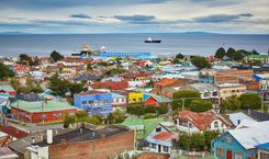
Dramatically situated at the foot of the 800m coastal cordillera, with an enormous sand dune looming precariously above one of its barrios, Iquique, 390km north of Calama, is a sprawling, busy and surprisingly cosmopolitan city. The town is also fast gaining a reputation as one of the world’s finest spots for paragliding. Predictably cloudless skies and winds that come in off the Pacific and rise up the dunes create near-perfect conditions; you’ll see many enthusiasts swooping down to the beaches, silhouetted by dawn or dusky sunsets. Iquique rivals Arica as the best place to base yourself for a tour of the extreme northern tip of the country. From here, you can easily arrange excursions into the interior, whose attractions include the famous nitrate ghost towns of Humberstone and Santa Laura (both UNESCO World Heritage sites), the beautiful hot-spring oases of Pica and Matilla, and the stunning altiplano scenery of Parque Nacional Volcán Isluga.
Iquique falls into two quite distinct areas: downtown, lined with shops, services and old historic buildings, and the modern stretch along the oceanfront, given over almost entirely to tourism.
Iquique’s central square and main avenue conserve some splendid buildings from the nitrate era, which, along with the city’s beaches, are for many people a good enough reason to visit. Seizing upon this, the authorities have invested in an ambitious restoration scheme aimed at enhancing the beauty of this historic part of the city. Still more people, mainly Chileans, head here for the duty-free shopping at Iquique’s Zona Franca, or “Zofri”.
Iquique started out as a small settlement of indigenous fishing communities, and during the colonial period became a base for extracting guano deposits from the coast. It continued to grow with the opening of a nearby silver mine in 1730, but it wasn’t until the great nineteenth-century nitrate boom that it really took off as a city.
Following its transferral to Chilean hands during the War of the Pacific (1878–83), Iquique became the nitrate capital of Chile – where the largest quantities of ore were shipped from, and where the wealthy nitrate barons based themselves, building opulent mansions all over the rapidly expanding city. By the end of the nineteenth century, Iquique was the wealthiest and most hedonistic city in Chile – it was said that more champagne was consumed here, per head, than in any other city in the world.
With the abrupt end of the nitrate era after World War I, Iquique’s boom was over, and the grand mansions were left to fade and crumble as the industrialists headed back to Santiago. Fishing stepped in to fill the economic gap and over the years Iquique transformed itself into the world’s leading exporter of fishmeal, though copper subsequently took over as the city’s main industry.
Two beaches lie within striking distance of the city centre: Playa Cavancha, the nearest, most popular, and more sheltered; and Playa Brava, larger, less crowded and more windswept, which is only suitable for sunbathing due to a strong current and crashing waves rendering it dangerous for swimming (although you do see adrenalin junkies surfing at either end of the beach). You can walk to Playa Cavancha, which begins at the southern end of Amunategui, but it’s very cheap to take one of the numerous taxis constantly travelling between the plaza and the beach; many continue to Playa Brava, as well, for a slightly higher fare. Further south, between Playa Brava and the airport, there’s a series of attractive sandy beaches including Playa Blanca, 13km south of the centre, Playa Lobito, at Km 22, and the fishing cove of Los Verdes, at Km 24. You can get to these on the airport bus or colectivo.
A number of Iquique tour companies offer one-day circular tours taking in the nitrate ghost towns of Humberstone and Santa Laura; the geoglyphs of Pintados; the oases villages of Matilla and Pica, with a plunge in Pica’s hot springs; and the basilica and nitrate museum of La Tirana. Another standard tour offered by some companies is the highly memorable route up into the cordillera, continuing north across the altiplano and descending in Arica; these excursions take in Parque Nacional Volcán Isluga, the Salar de Surire and Parque Nacional Lauca.
With the proposed Ruta Altiplánica de Integración – a paved highway stretching 1500km across the altiplano, from San Pedro de Atacama in Chile to Cusco, Peru – still not having come to fruition, crossing the altiplano’s pothole-riddled dirt tracks by jeep remains the road adventure of a lifetime and should be enjoyed to the full before the arrival of tarmac and increased traffic. Probably the best starting point is Iquique (the ascent in altitude is more gradual in this direction), heading into the cordillera as far as Parque Nacional Volcán Isluga, continuing north across the altiplano to Parque Nacional Lauca, and finally descending in Arica. It’s a 700km journey, and takes about four days at an easy pace.
If you do the trip, remember that there’s no petrol station once you’re off the Panamericana, which means taking it all with you in jerry cans (bidones, available in most ironmongers). Always take far, far more than you think you need. Another essential precaution is to take two spare tyres, not just one.
Iquique lies within easy reach of many inland sights. Just half an hour away, Humberstone and Santa Laura are perhaps the most haunting of all the nitrate ghost towns. South of here, close to the Panamericana, Cerro Pintados features a dense collection of geoglyphs, among the most impressive in Chile. East of Pintados sits the pretty oasis village of Pica, with a lovely thermal pool, while Mamiña, further north, is the Norte Grande’s hot-springs town par excellence. You can also visit La Tirana, an important pilgrimage centre, famous for its colourful festival in July. Public transport around this area is sporadic but manageable.
The best-preserved ghost town in Chile, Humberstone is a nitrate oficina that was abandoned in 1960 and today appeals especially to lovers of industrial architecture. It sits some 45km inland from Iquique, by Ruta 16 just before it meets the Panamericana. The town began life in 1862 as Oficina La Palma, but was renamed in 1925 in honour of its British manager, James “Santiago” Humberstone, an important nitrate entrepreneur famous for introducing the “Shanks” ore-refining system to the industry. In its time it was one of the busiest oficinas on the pampas; today it is an eerie, empty ghost town, slowly crumbling beneath the desert sun.
What sets Humberstone apart from the other ghost towns is that just about all of it is still standing – from the white, terraced workers’ houses (now in total disrepair) and the plaza with its bandstand, to the theatre, church and company store. The theatre, in particular, is highly evocative, with its rows of dusty seats staring at the stage. You should also seek out the hotel, and walk through to the back where you’ll find a huge, empty swimming pool with a diving board – curiously the pool is made from the sections of a ship’s iron hull. Located a short distance from the town are the sheds and workshops, with old tools and bits of machinery lying around, and invoices and order forms littering the floors.
At Santa Laura, about 2km down the road and clearly visible from Humberstone, you’ll see only a couple of remaining houses, but the processing plant is amazing, seeming to loom into the air like a rusty old dinosaur. As you walk around the site, listening to the endless clanging of machinery banging in the wind, the sense of abandonment is nigh-on overwhelming.
About 20km south of the junction between Ruta 16 and the Panamericana, the latter passes through the Reserva Nacional Pampa del Tamarugal, an extensive plantation of wispy, bush-like tamarugo trees. These are native to the region and are especially adapted to saline soils, with roots that are long enough to tap underground water supplies. While the tamarugos aren’t really interesting enough to merit a special trip, you can take a look at them on your way to the far more impressive Cerro Pintados, with the largest collection of geoglyphs in South America, situated within the reserve’s boundaries.
Extending 4km along a hillside, the Cerro Pintados site features approximately four hundred images (not all of them visible from the ground) of animals, birds, humans and geometric patterns, etched on the surface or formed by a mosaic of little stones around the year 1000 AD. The felines, birds, snakes and flocks of llamas and vicuñas scratched into the rock are thought to have been indicators for livestock farmers. The circles, squares, dotted lines and human figures are more enigmatic, however, and may have had something to do with rituals, perhaps even sacrifices.
As you cross the vast, desert pampa, the neighbouring oases of Pica and Matilla first appear as an improbable green smudge on the hazy horizon. As you get nearer, it becomes apparent that this is not a mirage and you are, indeed, approaching cultivated fields and trees. It’s a remarkable sight, and anyone who has not seen a desert oasis should make a special effort to visit. By far the larger of the two oases, PICA is a sleepy little town overflowing with lemon and lime trees, bougainvilleas and jasmine.
It’s the largest supplier of fruits to Iquique – limas de Pica are famous throughout the country – and one of the treats of visiting is drinking the delicious jugos naturales – orange, mango, pear, guava and grapefruit juices – freshly squeezed in front of you in the little streetside kiosks. The tidy plaza, by the entrance to town, is overlooked by a beautiful, pale-coloured church dedicated to St Andrew. It has a grand Neoclassical facade and was built in 1880.
Pica’s real selling point is the Cocha Resbaladero, a gorgeous hot-springs pool carved into a rocky hollow with two caves at one end. It’s quite a walk from the main part of town, but there are several places to stay up here if you want to be close to the waters. To enjoy the waters in peace, arrive early before the buses of day-trippers start arriving at midday.
A paved road branches east from the Panamericana at Pozo Almonte and climbs gently through the desert to Mamiña, 125km – a two-and-a-half-hour drive – northeast of Iquique. First impressions are not encouraging; huddled on a hillside overlooking a valley, its narrow streets and crumbling stone houses seem to belong to a forgotten town, left to the mercy of the heat and dust. Continue down the valley, however, and its charms become more apparent as you come upon the fertile terraces emerald with alfalfa, and the little stream running through the gorge (quebrada).
The real lure of Mamiña, though, is the hot springs for which the town is famous throughout Chile; the delicious bottled mineral water from here is on sale in the region only, as production is small. Unlike Pica, Mamiña doesn’t have just one hot spring, but many, and their waters are piped to every house in the village.
Furthermore, these waters are not merely hot, but are reputed to cure all manner of afflictions, from eczema and psoriasis to respiratory problems and anxiety. Indeed, the town is named in honour of an Incan princess whose blindness was reputedly cured here. Whatever their medicinal value, there’s no doubt that the waters are supremely relaxing to bathe in. This you can do in any of the village’s hotels or residenciales, usually in your own private tina, or bathtub.
Looking around the desert pampa, it’s hard to believe that this scorched, lifeless wasteland was once so highly prized that a war was fought over it – and still more difficult to imagine it alive with smoking chimneys, grinding machinery, offices, houses and a massive workforce. But less than a century ago, the Far North of Chile was the scene of a thriving industry built on its vast nitrate deposits, heavily in demand in Europe and North America as a fertilizer. Nitrates were first exploited in the Atacama Desert in the 1860s, when the region belonged to Bolivia (around Antofagasta) and Peru (around Iquique and Arica). From the early stages, however, the Chilean presence was very strong, both in terms of capital and labour.
When in 1878 the Bolivian government violated an official agreement by raising export taxes on nitrate (hitting Chilean shareholders, including several prominent politicians), Chile protested by sending troops into Antofagasta. Two weeks later, Chile and Bolivia were at war, with Peru joining in (on the Bolivian side) within a couple of months. The War of the Pacific went on for five years, and resulted in Chile taking over all of the nitrate grounds.
With the return of political stability after the war, the nitrate industry began to boom in earnest, bringing in enormous export revenues for Chile, and a trail of processing plants, known as oficinas, sprang up all over the pampa. Each oficina sat in the centre of its prescribed land, from where the raw nitrate ore was blasted using gunpowder. The chunks of ore, known as caliche, were then boiled in large copper vats, releasing a nitrate solution which was crystallized in the sun before being sent down to the ports to be shipped abroad. The plants themselves were grimy, noisy places. It was a hard life for the labourers, who worked long hours in dangerous conditions, and were housed in squalid shacks, often without running water and sewerage. The (mostly British) managers, meanwhile, lived in grand residences, dined on imported delicacies and enjoyed a whirl of elegant social activities. Nitrate provided more than half of the Chilean government’s revenues until 1920, by which time the boom was over and the industry in decline.
It was World War I that dealt the first serious blow to the nitrate companies, when the suspension of sales to Germany – Chile’s major European buyer – forced almost half the oficinas to close down. The final death knell was sounded when Germany, forced to seek alternative fertilizers, developed cheap synthetic nitrates which quickly displaced Chile’s natural nitrates from their dominant role in the world market. Most of what was left of the industry was killed off by the World Depression in the 1930s, and today just one oficina – María Elena – remains in operation.
At the one-horse town of Huara, 33km up the Panamericana from the turn-off to Iquique, a good road branches east into the desert, then climbs high into the mountains, continuing all the way to Oruro in Bolivia. It’s paved as far as Colchane, on the Chilean side of the border, but the main appeal lies in getting off the tarmac once you’re up into the cordillera and heading for the deserted wilderness in and around Parque Nacional Volcán Isluga. Here you’ll find a remote, isolated landscape of wide plains, dramatic, snowcapped volcanoes (one of which is the park’s namesake) and semi-abandoned villages, home to indigenous Aymara herding communities that have been a part of this windswept land for thousands of years.
Unlike Parque Nacional Lauca, further north, this region hasn’t yet been “discovered”, and it’s unlikely you’ll come across many other tourists. There are a number of attractions on the way up, as well, in particular the weird desert geoglyph known as the Gigante de Atacama, in the pampa, and the frozen geysers of Puchuldiza, on the lower slopes of the Andes.
Most people whizz up the Panamericana between Iquique and Arica in about four hours without stopping, but some 80km north of the turn-off to Iquique, a poorly paved side road (no public transport) leads 52km west down to Pisagua – a crumbling, evocative nitrate port that makes an interesting option for a night’s stopover. The final stretch down to the port is very steep, giving dramatic views down to the little toy town cowering by the ocean, the only sign of life on this barren desert coast.
Pisagua is a funny sort of place, part scruffy, ramshackle fishing town, part fascinating relic of the past. It was one of the busiest and wealthiest ports of the nitrate era, and is still dotted with many grand nineteenth-century buildings, some of them restored and repainted, others decaying at the same slow pace as the rest of the town (which has only about 150 inhabitants today). Most striking of all is the handsome, white-and-blue timber clock tower, built in 1887 and still standing watch from the hillside.
Ten kilometres north of the turn-off for Pisagua, just before the bridge across the Quebrada de Tiliviche, a short track branches left (west) to the Hacienda de Tiliviche. At the end of the track you’ll find the old casa patronal, a charmingly dilapidated house overlooking a yard full of clucking chickens and lethargic dogs. It was built in 1855 for a British nitrate family and remained in British hands until very recently; the current owners have plans to renovate it and turn it into a hotel.
The southern wall of Tiliviche’s quebrada also features some of the most impressive geoglyphs in Chile. They’re best viewed from the lay-by just off the Panamericana, a few hundred metres up from the bridge on the northern side of the quebrada. From this vantage point, you can see the images in all their splendour – a large crowd of llamas covering the hillside. All of the llamas are moving in the same direction, towards the sea, and it’s thought that the drawings were designed to guide caravans descending from the mountains on their journey towards the coast.
Avenida Diego Portales extends out of Arica’s city centre into the green Azapa Valley. The far western end of the valley is, to all intents and purposes, a suburb of Arica, crammed as it is with condos and villas, some of which have been converted into trendy discos, along with a couple of good restaurants. The highlight of a trip to the Azapa Valley is the Museo Archeológico, which houses a collection of the world’s most ancient mummies. This museum is among Chile’s best and is definitely worth the trip out here. If you’re booked on a multi-day tour of the Altiplano, it’s very likely this will be a stop-off.
In 1983, while laying a new pipeline near the foot of El Morro, the Arica water company came across a hoard of withered corpses buried a couple of metres beneath the sand. Work immediately ceased and archeologists from the University of Tarapacá were rushed in to assess the scene, which turned out to be a seven-thousand-year-old burial site containing 96 bodies – the largest and best-preserved find, to date, of Chinchorro mummies.
The ancient practice of mummification in this region – the oldest known in the world – was first identified in 1917 when a series of highly unusual human remains were discovered. Further excavations revealed similar findings spread along the coast, concentrated between Arica and Camerones, 65km south, and it became apparent that they were relics of an ancient society that archeologists have named the Chinchorro culture. Modern radiocarbon dating has established that the practice was well under way by 5000 BC – more than two millennia before the Egyptians began practising mummification.
No one knows exactly where the Chinchorro people came from; some archeologists speculate that they moved down from the north, others that they came from the Andean highlands. What’s clear, however, is that by 7000 BC scattered groups of people – possibly extended families – were spread along the coast of Chile’s Far North, where they lived on the abundant crabs, clams, mussels, seaweed, pelicans, sea lions and other marine life of the region, supplementing their diet with guanaco and wild berries.
The great simplicity of their hunter-gatherer lifestyle makes the sophisticated techniques they developed to preserve the dead all the more extraordinary. The practice involved removing the brain through a hole at the base of the skull, and removing all internal organs, which were probably discarded. After this, the cavities were dried with hot stones or fire and then refilled with straw and ashes. The bones of the arms and legs were replaced with sticks bound into place with reeds, and the skeleton was given extra padding before the body was stitched up. The face was then coated in paste, which dried into a hard mask with a sculpted nose and incisions marking the eyes and mouth. The finishing touch was provided by a wig made of human hair, which was attached to the skull.
The Chinchorro culture performed this elaborate process for over three thousand years until, for unknown reasons, the practice died out around 1500 BC, and the era of the oldest known form of artificial mummification came to an end.
A few hours east of Putre, up in the cordillera, Parque Nacional Lauca has become one of the most popular attractions in the north of Chile. A few of Arica’s tour operators will get you there if you don’t relish the idea of driving yourself.
A 4400-metre-high mountain pass signals the boundary of Parque Nacional Lauca. Up here the air is thin and cold, and the road is flanked by light-green bofedal (highland pasture) where herds of wild vicuña come to feed in the mornings. Ten kilometres into the park, you reach the Conaf hut (erratic opening hours) at Las Cuevas, a good place to stop to check on weather and road conditions and observe the comical antics of vizcachas, cuddly chinchilla-like rodents with curly tails and a spring-like leap.
Parque Nacional Lauca doesn’t offer a great many hiking possibilities, and most people are content to just admire the scenery and the wildlife. There are, however, at least three half-day or day walks you can do, and many more possibilities for climbing. Remember to respect the altitude, and to allow yourself more time to cover distances that you could walk quite easily at lower elevations. You must get authorization from DIFROL (governmental borders organization) if you are planning on climbing any or the mountains or volcanoes in the region. Fill in the authorization form on their website (difrol.cl) at least two days before climbing, or else ask Putre’s municipalidad to do it for you.
No technical experience or equipment is necessary to climb this 5288m peak, reached in about four hours from the refugio at Lago Chungará. From the top, you get views down to the gold mine behind the mountain, and on to Lago Chungará and Volcán Parinacota.
A slow but straightforward climb up this 5096m peak is rewarded by panoramic views over the park. It’s suitable for any fit person used to hill-climbing and takes around four hours to the top from the Conaf centre at Parinacota, and two to three hours back down.
This 18km walk from the refugio at Lago Chungará to Parinacota takes about six hours. Follow the paved highway as far as the mirador de Lagunas Cotacotani, then climb down to the lakes, from where a jeep track continues to Parinacota.
A rewarding, not-too-difficult walk, taking about three hours (one way) from Parinacota; ask the Conaf guardaparque to point you in the direction of the jeep track you need to follow.
An easy, 6km circular walk, marked by blue stones starting behind the Conaf centre, taking you past the bofedal de Parinacota, where you can observe numerous grazing alpaca. Good views onto surrounding mountains. Allow two to three hours.
Suitable only for experienced climbers carrying crampons and ropes (though it’s not always necessary to use them). Allow two days to get up and down from the base camp (a day’s hike from Parinacota), including one night camping on the volcano. Avoid this climb between mid-December and February, because of the weather conditions. Volcan Parincota’s brother volcano, Pomerape, is just across the border and makes an equally interesting climb.
Directly south of Parque Nacional Lauca, the Reserva Nacional las Vicuñas stretches over 100km south across spectacular altiplano wilderness filled with wild vicuña, green bofedales, abandoned Aymara villages, groves of queñoa – spindly, rickety-looking trees belonging to a species that miraculously defies the treeline – and sweeping vistas of volcanoes. The reserve’s administrative centre is about a ninety-minute drive from Putre, in Guallatire (4428m altitude), a pretty hamlet with a traditional seventeenth-century Andean church. There’s also an obligatory carabineros checkpoint here, and a Conaf refugio that is seldom in service. Looming over the village, snowcapped Volcán Guallatire puffs wispy plumes of smoke from its 6060m peak, while a grassy-banked stream snakes at its foot.
Following the road south of Guallatire, you’ll be rewarded, about 40km on, with sudden, dramatic views of the Salar de Surire, a dazzling white salt flat containing several lakes with nesting colonies of three species of flamingo. Originally part of Parque Nacional Lauca, its status was changed to that of national monument in 1983 to allow borax to be mined from its surface. The mining is still going on today, and you can see the mine’s enormous trucks driving over the salar, dwarfed by its massive dimensions but a nuisance nonetheless.
Top image © Shutterstock
Use Rough Guides' trusted partners for great rates
written by
Rough Guides Editors