Easter Island and the Juan Fernández Archipelago Travel Guide

Chile’s two remote island territories, enchanting Easter Island and the virtually unknown Juan Fernández Archipelago, are collectively referred to as the Islas Esporádicas (“Far Flung Isles”). Both are national parks and have been singled out by UNESCO for special protection. Neither is easy to get to, and most travellers never do, but those who make the journeys will find their efforts and expenditure richly rewarded with a set of tantalizingly enigmatic statues and one of the world’s most precarious ecosystems, respectively.

What to see on Easter Island and the Juan Fernández Archipelago

Lost in the vastness of the ocean, tiny Easter Island (or, in Spanish, Isla de Pascua) remains a world unto itself, its closest inhabited neighbour being Pitcairn Island, 2250km northwest. Spanning just 23km at its longest stretch, the island is triangular, with low-lying extinct volcanoes rising out of each corner. Scattered between these points are dozens of moai, the intriguing monolithic stone statues that have made the island universally famous.

Much closer to the mainland, at a mere 675km west of Valparaíso, but still relatively unknown, the Juan Fernández Archipelago is, ironically, far more difficult to reach. With their sharp, jagged peaks, coated in lush, deep-green foliage, the islands boast a topography that is among the most spectacular in Chile.

The archipelago’s largest and only permanently inhabited island – Isla Robinson Crusoe – started out as a pirates’ refuge. In 1709 it was brought to public attention when Scottish seaman Alexander Selkirk was rescued from its shores after being marooned there for more than four years - a story was used as the basis for The Adventures of Robinson Crusoe. Today the Juan Fernández Archipelago, badly affected by a tsunami triggered by the 2010 earthquake, remains an adventurous destination, well off the beaten track.

Easter Island

One of the most remote places on earth, tiny Easter Island is home to around seven thousand people. Around half are indigenous (who generally refer to themselves as Rapa Nui; mainland Chileans call them pascuenses), with the rest being mainly continentales (mainland Chilean immigrants). The Rapa Nui have fine-boned Polynesian features and speak their own Polynesian-based language (also called Rapa Nui) in addition to Spanish. Virtually the entire population lives in the island’s single settlement, Hanga Roa, and most islanders make their living from tourism, which has been growing steadily ever since an airstrip was built here in 1968.

The key points of interest are found within Parque Nacional Rapa Nui, which comprises much of the island. Highlights include Rano Kau, a huge volcanic crater and site of the ceremonial village of Orongo; the Rano Raraku quarry, where almost all the moai were carved; and the largest ahu (platform) on the island, Ahu Tongariki, which boasts fifteen moai. Archaeological treasures aside, Easter Island has much to offer outdoor enthusiasts, from diving in waters with arguably the best visibility in the world to surfing major waves off the island’s south coast.

Brief history of Easter Island

Easter Island was “discovered” and named by Dutch naval commander Jacob Roggeveen on Easter Sunday, 1722. In the absence of any written records left by the islanders, Roggeveen’s log is the earliest written account of the island. His party spent only a single day on land, long enough to observe the “particularly high erected stone images”. After their departure, it was another 48 years before Easter Island was revisited, this time by Spanish commander Felipe González, who mapped the island and claimed it for King Carlos III of Spain during a six-day stay.

Four years later, Captain Cook anchored here in the hope of restoring the health of his scurvy-ridden crew. He, too, observed with incredulity the “stupendous figures”, though he noted that some lay strewn on the ground, toppled from their platforms. Later visitors reported an increasing number of fallen statues, and by 1825 all of the moai on Hanga Roa bay had been destroyed.

The arrival of the slave traders

In 1805, the island was raided by the first of the slave traders, when an American schooner captured 22 men and women to be used as seal hunters on the Juan Fernández Islands. After three days at sea, the prisoners were allowed onto the deck, whereupon they promptly threw themselves overboard and drowned in a desperate attempt to swim back to the island. Between 1862 and 1864, Peruvian sailors captured over two thousand five hundred islanders, who were shipped off to work as slaves in the guano mines.

After many of the islanders had died from disease and the appalling conditions in the mines, the Bishop of Tahiti finally managed to persuade the Peruvian government to repatriate the remaining prisoners – most of whom died on the voyage home. Tragically, the sixteen who made it back infected the rest of the islanders with smallpox and TB, reducing the population to around one hundred. Critically, the loss of life was accompanied by the loss of a crucial part of the island’s culture and collective memory, for the last ariki henua (high chief), moari (keepers of sacred knowledge) and tangata rongo rongo (specialist readers) were among those who perished.

Missionaries and plantations

A certain degree of stability came when the first missionary, Eugène Eyraud, arrived in 1864 and set to converting the islanders to Christianity, a mission fully accomplished by the time of his death, four years later. The peace was disrupted, however, when a French plantation owner, Jean-Baptiste Onésime Dutrou-Bornier, bought up large tracts of land and proceeded to run the island as his personal ranch, paying the islanders a pittance for their hard labour and resorting to violence when they wouldn’t cooperate. When the missionaries opposed Doutrou-Bornier’s exploitation, he attacked their missions, forcing them to flee the island. He dealt a further blow to the island’s slowly recovering population by sending all but a hundred islanders to Tahiti to work on his partner’s plantation, before finally being murdered in 1877 by the oppressed islanders.

Chile’s annexation

The Chilean government acquired first Doutrou-Bornier’s lands, and then most of the remaining land on the island, leaving only the village of Hanga Roa in the possession of the islanders. Then, on September 9, 1888, the Chilean Navy – apparently with the islanders’ consent – officially annexed Easter Island, declaring it Chilean territory. Chile subsequently leased it to Williamson Balfour, a British wool-trading company, which virtually governed the island according to its own needs and interests.

In 1953, the company’s lease was revoked and the Chilean Navy stepped in to resume command, though the islanders were given no say in the running of the island. It was not until 1964, that they were allowed outside Hanga Roa (let alone off the island), and granted full citizenship and the right to vote.

The drive towards autonomy

Since the return to democracy, the management of some local affairs, including education, which is now bilingual, has been transferred to the islanders. However, many continue to call for greater autonomy and even secession, expressing concern over the pace of development, the impact of the growing tourist industry and the increasing numbers of mainland Chileans settling on the island. At the time of writing, legislation was set to be passed in the Chilean parliament to give the Easter Island authorities greater powers to regulate tourist numbers (and potentially levy a visitor charge).

Best time to visit Easter Island

Easter Island is two hours behind mainland Chile. The weather is fairly constant year-round, with an average temperature of 23°C (73°F) in January and February, and 18°C (64°F) in July and August. Late January and early February is the busiest time, as the islanders stage the annual Tapati Rapa Nui festival.

Easter Island festivals

To witness the island’s culture at its best, time your visit to coincide with one of the festivals. Tapatai Rapa Nui is a ten-day cultural celebration held in late January or early February. Famous for celebrating Rapa Nui culture, tradition and history, the festival features dancing, body painting, statue carving, choral recitals, surfing displays, canoe races, re-enactments of old legends and huge curanto feasts. Semana Santa (Easter week) features lively celebrations at Hanga Roa’s church. The Ceremonia Culto al Sol is a feast that takes place on June 21 for the winter solstice, while Día de la Lengua Rapa Nui, a celebration of the Rapa Nui language, is held in late November.

Easter Island tours and activities

There are several ways to explore Easter Island, whether you want to get active or take a guided tour; the following operators are reliable. Almost all the hotels, and many of the guesthouses, offer tours, notably Hotel Taura’a and Aukara Lodge.

  • Aku Aku TurismoBilingual tours to all the main sites.
  • Cabalgatas PantuHorseback tours of the west and north coasts, including the ascent of Maunga Terevaka, the island’s highest point, plus overnight camping trips.
  • Easter Island SpiritExcellent private tours that take in both the main sights and little-explored places; they are particularly good for keen photographers. Book online.
  • Kava Kava ToursRecommended private tours throughout the island, including sunrise and sunset excursions. Book online.
  • Kia Koe TourBilingual tours to sites across the island.
  • Mike Rapu Diving CentreA range of scuba diving and snorkelling trips. They also rent out kayaks and offer boat tours.
  • Orca Diving CenterThe well- established outfit offers scuba diving and snorkelling trips. Hare Orca, next door and attached to the centre, rents surfboards, boogie boards and snorkelling gear; the shop can put you in touch with surfing instructors.

Hanga Roa

The laidback town of Hanga Roa has been the island’s only residential sector since

the 1860s, when Catholic missionaries relocated the islanders here to facilitate their conversion. Its long, sprawling streets are lined with single-storey houses and fragrant eucalyptus trees, giving the place the feel of a recently settled frontier town.

Atamu Tekena is the main road, lined with souvenir shops, restaurants and tour agencies. Most of the action is centred around the Caleta Hanga Roa harbour, overlooked by Ahu Tautira, the only moai in the town proper. Restaurants stretch from here along oceanside Policarpo Toro, parallel to Atamu Tekena. East-west Te Pito O Te Henua connects the two, ending at the church, where islanders still congregate every Sunday morning. Just south of the pier lies tiny Playa Pea, where a rock pool safe for swimming is cordoned off from the stretch of ocean popular with surfers and bodyboarders.

The southeastern circuit

Ahu Vinapu

From Hanga Roa, follow Avenida Hotu Matu’a down to the southern coast road then turn right, just after the white oil containers, and you’ll reach Ahu Vinapu, the site of two large ahus, with moai lying in fragments behind the platforms. Anyone who’s seen Machu Picchu or other Inca ruins will be amazed by the similarity of the masonry of Vinapu’s main ahu, made of huge, mortarless blocks of stone “fitted carefully to one another without a crack or a hole”. Close to this platform, known as Vinapu I, is another ahu, Vinapu II, whose stonework is vastly inferior to its neighbour.

Thor Heyerdahl’s expedition was the first to excavate the site and, with radiocarbon dating, concluded that the precisely carved Vinapu I was among the earliest built

on the island, and that Vinapu II was a much later construction, suggesting that the island’s first settlers imported the highly specialized stone-carving techniques of Peru, and that later platforms were built by “far less capable architects, who were no longer masters of the complicated Inca technique”. Modern archaeologists, however, believe that this impressive masonry is simply a perfected example of a style developed locally on Easter Island, and more recent radiocarbon tests have given Vinapu I a new date of 1516 AD, and Vinapu II a date of 857 AD – the reverse of Heyerdahl’s sequence.

Sites along the southern coast

East from Vinapu on the coast road, the first site you pass is Ahu Vaihu, where eight tall statues lie face-down on the ground, their red stone topknots strewn along the coast. Three kilometres further along, Ahu Akahanga presents an equally mournful picture of a row of fallen moai; according to some oral traditions, it’s also the burial place of Hotu Matu’a. Further up the coast, Ahu Hanga Tetenga is the site of the tallest moai (9.94m) ever transported to a platform.

Just beyond Ahu Hanga Tetenga, the road forks. The left-hand branch (Camino de los Moai) leads to the quarry of Rano Raraku. It’s thought to have been the main roadway along which the statues were transported from the quarry. The right-hand branch continues up the coast to the magnificent Ahu Tongariki.

Ahu Tongariki

The fifteen colossal moai lined up on Ahu Tongariki make a sensational sight. This was the largest number of moai ever erected on a single ahu, which, at 200m long, was the largest built on the island. It was destroyed in 1960 when a massive tsunami, triggered by an earthquake in Chile, swept across this corner of the island, dragging the platform blocks and the statues 90m inland – a remarkable distance, given that the statues weigh up to 30 tonnes each.

In November 1988, Sergio Rapu, a former Governor of Easter Island, stated during an interview for a Japanese TV show that if they had a crane they could save the moai; a Japanese man watching the show decided to act and a committee was established. The restoration of the ahu involved Chilean archaeologists Claudio Cristino and Patricia Vargas, a group of forty islanders, specialists from the Nara Institute of Japan and recognized international experts in stone conservation. The five-year project was completed in 1995.

Rano Raraku

North of Tongariki, Rano Raraku rises from the land in a hulking mass of volcanic stone. This crag is where almost all of the island’s statues were produced, carved directly from the “tuff” (compacted volcanic ash) of the crater’s outer slopes. The first surprise, on approaching the crater from the car park, are the dozens of giant heads sprouting from the ground. They are, in fact, finished moai brought down from the quarry, which were probably placed in shallow pits (that gradually built up) until they could be transported to their ahu. One of them bears an image on its chest of a three-masted sailing ship, suggesting that they were carved after European contact.

Among this mass of shapes, still attached to the rock face, is El Gigante, the biggest moai ever carved, stretching over 20m from top to bottom. Experts believe that it would have been impossible to transport, let alone erect.

The east end of the trail culminates in the kneeling, round-headed Moai Tukuturi, the only one of its kind, discovered by Thor Heyerdahl’s expedition in 1955. To the west, the trail winds its way up between wild guava trees into the crater itself, with several dirt paths running through knee-high shrubbery alongside the large reed-strewn, freshwater lake. If you follow the trails all the way up to the crater’s eastern rim (avoid treading on the toppled moai at the top) you are rewarded with unparalleled views of the bay and Ahu Tongariki in the distance.

The myth of the "Long Ears" and the "Short Ears".

An oft-repeated oral tradition has it that the island’s population, in the time just before the toppling of the statues, was divided into two principal groups, the “Short Ears” and the “Long Ears”. In fact, the whole myth is based on a mistranslation. It seems the two clans were really the Hanau eepe (“short and stocky”) and the Hanau momoko (“tall and slim”); the strange mix-up came from mistranslating eepe – short and stocky – as “ear” (“epe” in Rapa Nui).

The Long Ears, who saw themselves as more aristocratic, were extremely domineering, and the Short Ears resented them intensely. The Short Ears rebelled when forced to clear rocks off the land, forcing the Long Ears to retreat to the Poike Peninsula. Here they dug deep ditches, and filled them with branches and grass, intending to force their enemies inside and set them alight. However, a Short Ears woman who was married to one of the Long Ears alerted her people, and allowed them to surround their enemies while they were sleeping. When they attacked, the Long Ears ran straight into their own ditch, which was set alight. Most of the Long Ears burned to death, but three escaped. Two of them were caught and executed, but one, Ororoina, was allowed to live, and went on to father many children – whose descendants, to this day, are proud of their Hanau momoko heritage.

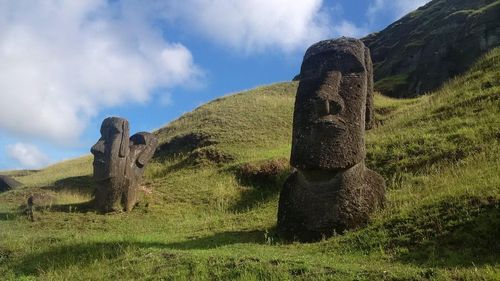
The Moai of Easter Island

Easter Island’s enduring symbol is the moai. A Neolithic statue cult on this scale would impress in any location, but the fact it developed in total isolation on a tiny island in the middle of the Pacific almost defies belief. There are some four hundred finished statues scattered around the island, and almost as many in the quarry, in varying stages of completion. The moai range in height from 2m to about 20m, and though styles evolved over time, all are carved in a highly stylized manner. Their bellies are gently rounded, and their arms are held tightly by their sides, with their strange, long-fingered hands placed across their abdomens. Their heads are long and rectangular, with pointed chins, prominent, angular noses and thin, tight lips.

Function and form

According to the islanders’ assertions, which are consistent with widespread Polynesian tradition, these figures represented important ancestors, and were erected on the ancestral land of their kin-groups, which they would watch over and protect with their mana (almost all the moai face inland). Archaeologists have proposed tentative dates of around 1000 AD for the carving of the early statues, and around the fifteenth century for the bulk of the statues, when production peaked. Rano Raraku’s unfinished statues demonstrate how their forms were chiselled out of the rock face until they were attached to it by just a thin keel running down their spine. When all was completed but their eye sockets, they were freed from their keel and slid down the quarry’s slope, then temporarily erected in a pit until they were transported to their ahus.

Transportation

The island’s oral histories offer no clues as to how the 20- to 25-tonne statues were moved, claiming the statues’ mana enabled them to walk short distances each day until they reached their platforms. Modern theories have included horizontal and vertical swivelling, but since it was established in the 1980s that the island was once densely covered by trees, it’s been assumed that they were dragged on wooden sledges or on top of rollers.

Raising the Moai

How the statues were erected onto their platforms in the absence of any type of machinery is another enigma, though in 1955, Thor Heyerdahl challenged the island’s mayor to raise a fallen, 25-tonne statue at Anakena Beach and, under the mayor’s supervision, twelve islanders raised the statue in eighteen days, using two levers and slipping layer after layer of stones underneath the horizontal statue. Little by little, it was raised on the bed of stones until it was level with its platform; at this point, the layers of pebbles were placed only under its head, until the statue was nearly vertical and could be slipped into place. Archaeologists agree this method is highly likely to have been used to raise the statues. In contrast, no one has been able to demonstrate how the large, heavy “topknots” were placed on the raised statues’ heads – a monumental feat, achieved only with a crane in modern times.

The statue-carvers

Easter Island society was based around independent clans, or kin-groups, each with its own high-ranking members. The statue-carvers were highly revered members of a privileged class who were exempt from food production and were supported by farmers and fishermen. Such a system must have involved a great deal of economic cooperation, which appears to have been successfully maintained for centuries.

The beginning of the end

Then, in the later stages of the island’s prehistory, the system collapsed, and the island became engulfed by warfare. Archaeological records reveal a sudden, dramatic proliferation of obsidian weapons during the eighteenth century, as well as the remains of violently beaten skulls, and evidence of the widespread use of caves as refuges. Archaeologists have also found possible evidence of cannibalism – which featured prominently in the island’s oral traditions. The most dramatic testimony of this period, however, is provided by the hundreds of fallen statues littering the island, deliberately toppled as enemy groups set out to desecrate each other’s sacred sites.

So what went wrong?

It seems likely the seeds of social collapse lay in the extremes the statue cult was taken to by the islanders. As the impulse to produce moai required more and more hands, the delicate balance between food distribution and statue-carving was destroyed. This situation was profoundly aggravated by the growing scarcity of food brought about by overpopulation, and deforestation, following centuries of logging for boat-building, fuel consumption and statue-transportation. This must have had a catastrophic effect on the islanders’ ability to feed themselves: deep-sea fishing became increasingly difficult, and eventually impossible, owing to the lack of wood available for new canoes, and even land cultivation was affected, as the deforestation caused soil erosion. In this climate of encroaching deprivation, the Easter Island civilization descended into anarchy, dragging its majestic monuments with it.

The northern circuit

Although the triangle formed by Vinapu, Tongariki and Anakena contains the densest concentration of sites, the western and northern parts of the island are also well worth exploring. Attractions include the impressive moai of Tahai and Ahu Akivi, plus a network of underground caves.

Tahai

If you walk north from the caleta past the cemetery, taking the road that hugs the coast, after about ten minutes you’ll reach the ceremonial centre of TAHAI, composed of three ahus, a favourite spot for viewing colourful sunsets. The first, Ahu Vai Uri, supports four broad, squat moai, two of which have badly damaged heads, and the stump of a fifth statue. In front of the ahu is the outline of a flattened esplanade, presumed to have been used as a ceremonial site.

Archeological remains suggest some individuals – possibly chiefs and priests – used to live near these ceremonial sites, in several locations on the island, in stone, oval houses called hare paenga that looked like an upturned canoe. You can see the foundations of one of these houses near Ahu Vai Uri. The second platform is Ahu Tahai itself, topped by a lone, weathered moai. Finally, Ahu Ko Te Riku is the site of a well-preserved moai fitted with white, glinting eyes and a red topknot.

Ana Kakenga

On the coastal road, around 3km north of the Museo Antropológico, you reach the point where you’re opposite two little islands. A stone cairn by the left-hand side of the road signals a track down towards the cliffs; it’s not easy to spot. At the end of the track, a tiny opening in the ground is the entrance to a pitch-black passage (take a torch), which continues 50m underground to the adjoining Ana Kakenga (Dos Ventanas Caves). Both caves are flooded with light streaming in from the “windows”, or gaping holes, that open out of the cliff wall. Prepare for a rush of adrenaline as you approach the edges, as both drop vertically down to a bed of sharp rocks and pounding waves many metres below.

Ahu Te Peu

About 1km further up the coast from the Dos Ventanas Caves is Ahu Te Peu. The moai that once stood on the ahu still lie flat on the ground, left as they were during the period of warfare. Scattered around are the remains of many boat-shaped hare paenga, including one that’s 60m long. It’s thought this was the site of the village of the Miru clan, the direct descendants of Hotu Matu’a.

At Ahu Te Peu, most people join up with the inland road and head back to Hanga Roa via Ahu Akivi. You can, however, continue north, either heading up the gentle volcanic cone of Terevaka, where you’ll be rewarded with fine views across the island from its 510m summit, the highest point of the island (no path; 1hr up), or else follow the coastline round to Playa Anakena (4–5hr on foot; sunscreen is absolutely essential and you must take plenty of water). On the way, you’ll pass many fallen moai, none of them restored, as well as the ruins of stone houses and chicken pens.

Inland to Puna Pau

From Hanga Roa, heading up the inland road to Ahu Akivi (first left from the paved road to Anakena) you’ll pass a signed track branching left to Puna Pau, a low volcanic crater made of rusty-coloured rock, known as scoria, where the islanders carved the pukao – the cylindrical “topknots” worn by up to seventy of the moai standing on ahu. No one knows for sure what these cylinders represented, though suggestions include topknots (of hair) and feather headdresses. Up in the quarry, and along the track to the top, you can see thirty or so finished pukao lying on the ground.

Ahu Akivi

On the inland road north of Puna Pau, the seven moai at Ahu Akivi are the only ones

to have been erected inland, and the only ones that look towards the sea. It’s been discovered that they are oriented directly towards the rising summer solstice, along with several other ahu, suggesting that solar positions were of significance to the islanders. The Ahu Akivi moai were raised in 1960 by William Mulloy and Gonzalo Figueroa, two archeologists recruited by Heyerdahl in 1955, both of whom devoted their careers to Easter Island.

Ana Te Pahu

From Ahu Akivi, the road turns towards the coast, where it meets Ahu Te Peu. On the way, a second path branches left from the main road, leading towards the Ana Te Pahu caves. If you clamber down, you’ll see some tall bamboo trees growing in a magical underground garden, along with sweet potatoes, taro, avocados, lemons and sugarcane. This cave is connected to another huge cave (once used as a dwelling) by a long lava tube.

South of Hanga Roa: Rano Kau

South of Hanga Roa, a dirt road climbs steeply past a mirador offering an excellent view of Hanga Roa up to one of the most awe-inspiring spots on the island – the giant crater of the extinct Rano Kau volcano, and the ceremonial village of Orongo, perched high on its rim. The dull waters of the volcano’s reed-choked lake contrast sharply with the brilliant blue of the Pacific, stretching as far as the eye can see, visible where a great chunk of the crater wall is missing. Just before you reach Orongo, a path disappears into the lush vegetation around the crater’s edge; it is possible to follow this around the crater as a leisurely day’s walk, but bring plenty of water.

Orongo

Orongo, just beyond the Conaf visitor centre, consists of the partially restored remains of some 48 low-lying, oval-shaped huts made of thin stone slabs, each with a tiny entrance just large enough to crawl through (don’t try). A few steps from the houses, on the face of some basalt outcrops looking out to sea, a dense group of exquisitely carved petroglyphs depict curled-up human figures with birds’ heads and long curved beaks. These images honour an important annual ceremony dedicated to the cult of the Birdman.

The Birdman ceremony

A great deal is known about the Birdman ceremony, which was practised right up to 1878. It took place annually at the September equinox, when the chiefs of the various kin-groups assembled at Orongo to compete. The aim was to find the first egg laid by the sooty tern (a migratory bird) on Motu Nui, the largest of three islets sitting opposite Orongo, 2km out to sea. Each chief would choose a representative, or hopu, who would scale down the sheer cliff to the ocean and swim through shark-infested waters to the islet. It could take several weeks for the egg to be found; meanwhile, the chiefs would remain in Orongo, where they participated in ritual dances, songs and prayers.

Once the egg was finally found, whoever discovered it would bellow the name of his master and then swim back to the island with the egg tucked into a headband. The victorious chief now became the new tangata manu, or Birdman. The new Birdman would first have all the hair shaved off his head; he would then live in strict seclusion for a whole year in a sacred house at the foot of Rano Raraku, eating only certain foods, and forbidden to bathe himself or cut his nails. His kin-group, meanwhile, was endowed with a special, high status, which was often taken as an excuse for members to dominate and bully their rival groups.

The Juan Fernández Archipelago

The Juan Fernández Archipelago is made up of three islands and numerous rocky islets. The archipelago is named after João Fernandes, the Portuguese sailor who discovered it on November 22, 1574, while straying out to sea to avoid coastal winds and currents in an attempt to shorten the journey between Lima and Valparaíso. The more easterly of the two main islands was originally called Más a Tierra (“Nearer Land”), while the other, 187km further west, was known as Más Afuera (“Farther Out”).

Brief history of the Juan Fernández Archipelago

João Fernandes made a brief attempt to colonize the three uninhabited islands, introducing vegetables and goats, which multiplied in great numbers (the third, smallest, island was later known as Goat Island, officially as Isla Santa Clara). These were still flourishing when British buccaneers started making occasional calls here to stock up on water and fresh meat between their raids on the mainland.

Following Alexander Selkirk’s much-publicized rescue buccaneers began calling at the islands more frequently, prompting the Spanish Crown to take official possession of the archipelago in 1742, building a series of forts around Más a Tierra. The island was then used as a penal colony for many years, and it wasn’t until the mid-nineteenth century that a mixture of Chilean and European colonizers formed a permanent settlement. In 1966, with an eye on the islands’ potential as a tourist destination, the Chilean government changed Más a Tierra’s name to Isla Robinson Crusoe, while Más Afuera became Isla Alejandro Selkirk, seasonal home to lobster fishermen and very difficult to reach.

Today, only a few hundred tourists make it out here each year, arriving mainly between October and March, when the climate is warm and mostly dry, and the sea is perfect for swimming.

Isla Robinson Crusoe

Twenty-two kilometres long, and 7km at its widest point, Isla Robinson Crusoe is the archipelago’s only permanently inhabited island. Most of the islanders – some of them descendants of the Swiss Baron de Rodt and his compatriots who settled the island at the end of the nineteenth century – live in the little village of San Juan Bautista, on the sheltered Bahía Cumberland. The main economic activity is trapping lobsters, and one of the highlights of a stay here is accompanying a fisherman out to haul in his catch (and later sample it).

Lobsters aside, the island’s two principal attractions are the sites associated with Alexander Selkirk and the richness of its flora and fauna. Of the 146 plant species that grow here, 101 are endemic or unique to the island (the second highest proportion in the world after Hawaii), which is both a national park and a UNESCO World Biosphere Reserve. Most prolific, and stunning, is the luxuriant rainforest that covers the island’s higher slopes.

The local fauna also comprises numerous endemic species, such as the Juan Fernández fur seal, which is making a comeback after being hunted to near-extinction in the eighteenth century, and the Firecrown hummingbird, as well as sea birds, such as the giant petrel. Meanwhile, diving at various sites around Isla Robinson Crusoe is an excellent way to appreciate the wealth and diversity of its abundant underwater life. Mosquitoes abound, so be sure to bring plenty of repellent.

The 2010 tsunami in Chile

In the early hours of February 27, 2010, a tsunami triggered by the 8.8 magnitude earthquake on mainland Chile struck the Juan Fernández Archipelago. A wave of around 20m in height swept 300m into Isla Robinson Crusoe, destroying much of San Juan Bautista and killing sixteen people. A mix-up between the Chilean Navy and the tsunami alert services meant that the islanders received no official warning, and the death toll would have been much higher but for a 12-year-old girl: awake at night, Martina Maturana spotted the fishing boats bobbing violently in the harbour, and ran from her home to ring the emergency bell in the town square to warn the island’s six hundred or so inhabitants.

Following the disaster, the island’s population fell by about a third, as many people left for the mainland. Islanders, angry at the lack of official warning, launched a court case against the government. Meanwhile, rebuilding attempts - the tsunami destroyed the island’s library, town hall, civil registry office, museum, cultural centre, naval offices, post office, school and every single shop, as well as many homes and hotels – are ongoing.

To compound matters, on September 2, 2011, 21 passengers were killed after an air force plane crashed into the sea after twice failing to land in windy conditions on the island. Among those killed was TV presenter Felipe Camiroaga, who had been making a film on the reconstruction efforts.

Alexander Selkirk

Daniel Defoe’s story of Robinson Crusoe, the world’s most famous literary castaway, was inspired by the misadventures of the real-life Scottish mariner Alexander Selkirk, who was marooned on Isla Robinson Crusoe (then Más a Tierra) in 1704 while crossing the Pacific on a privateering expedition. Unlike Crusoe, who was shipwrecked, Selkirk actually asked to be put ashore following a series of quarrels with his captain. The irascible sailor regretted his decision as soon he was deposited on the beach with a few scanty supplies, but his cries from the shore begging to be taken back onboard were ignored. Selkirk spent four years and four months on the island, with only his Bible and dozens of wild goats for company. During that time he was transformed into an extraordinary athlete, as he hunted the goats on foot, and a devout Christian.

Following his rescue by a British ship in 1709, however, Selkirk reverted to his buccaneering ways, joining in attacks on Spanish vessels all the way home. Back in Fife, the former castaway became something of a celebrity and threw himself into a life of drink and women. Fourteen years after his rescue, Selkirk finally met his end when he took up the seafaring life once more, set off on another privateering expedition, and died of fever in the tropics.

Top image © Shutterstock

Planning your own trip? Prepare for your trip

Use Rough Guides' trusted partners for great rates

Rough Guides Editors

written by
Rough Guides Editors

updated 26.04.2021

Ready to travel and discover
Chile?

Get support from our local experts for
stress-free planning & worry-free travels

Plan my trip ⤍