Planning your own trip? Prepare for your trip
Use Rough Guides' trusted partners for great rates
written by
Rough Guides Editors
Located immediately to the south of the Lake District, the fascinating Chiloé archipelago – part of a mountain range that sank below the waves following the last Ice Age – is a haven of rural tranquillity. The main island, Isla Grande, is South America’s second largest island. Sliced in half lengthways by the Panamericana, it connects the two main towns, Ancud and Castro, with the port of Quellón and is easily explored by bike, car or bus. The densely forested Parque Nacional Chiloé and Parque Tantauco offer great opportunities to explore unique Chilote wilderness, while coastal villages and islands off Isla Grande’s east coast – the most accessible being Isla Quinchao and Isla Lemuy – provide glimpses into traditional Chilote life.
Chiloé was originally populated by the native Chonos and Huilliche (southern Mapuche), who eked out a living from fishing and farming before the Spanish took possession of the island in 1567. For over three hundred years, Chiloé was isolated from mainland Chile owing to the fierce resistance of the mainland Mapuche to European colonists. As a result, the slow pace of island life saw little change. Ancud, in fact, was the last stronghold of the Spanish empire during the wars of Independence, before the final defeat by pro-independence forces in 1826. In spite of being used as a stopover during the California Gold Rush, Chiloé remained relatively isolated until the end of the twentieth century, though now it draws scores of visitors with its unique blend of architecture, cuisine and famous myths and legends.
More than 150 eighteenth- and nineteenth-century wooden churches and chapels dot the land. Chiloé is also one of the few places in the country where you can still see palafitos, precarious but picturesque timber houses on stilts, which were once the traditional dwellings of most of the fishermen of southern Chile. Much of the old culture has been preserved, assimilated into Hispanic tradition by a profound mixing of the Spanish and indigenous cultures that occurred here more than in other parts of South America, making today’s Chiloé more “pagan Catholic” than Roman Catholic.
Ancud is a pretty little seaside town and a lively fishing port; numerous visitors find themselves preferring the relaxed pace of life here to the hustle and bustle of grittier Castro. Built on a small, square promontory jutting into the Canal de Chacao and the Golfo de Quetalmahue, the town centres on the pretty Plaza de Armas (undergoing complete renovation at the time of writing), which fills with craft stalls and street musicians in the summer. The colourful Mercado Municipal, one block to the north, is the place to grab a cheap meal or pick up fresh produce and some local crafts, though there’s a more attractive temporary produce and crafts market a few blocks east of the centre along Arturo Prat.
The town also makes a good base for exploration of the northern half of the island. Among the attractions are a day-trip to the penguin colony at Puñihuil, a drive to the nearby Península Lacuy (itself the start of the Chiloé section of the Sendero de Chile) or a rattle along the gravel roads that link the tiny villages along the east coast.
Ancud was founded in 1769 as a Spanish stronghold and, after Peruvian independence in 1824, became the crown’s last desperate foothold in South America. Its forts resisted one attempt at capture, but finally fell in January 1826 when the lonely and demoralized Spanish garrison fled into the forest in the face of a small criollo attack. The remains of these Spanish forts – Fuerte San Antonio in the town and Fuerte Agüi on a peninsula to the northwest – can still be visited today.
Stronger than a blueberry. More powerful than the açai berry. Able to battle ageing and neurodegenerative diseases. Look! In the evergreen tree! It’s Maquí the Wonder Berry! The maquí berry (Aristotelia chilensis), also known as the Chilean wineberry, is native to Chile’s Valdivian rainforests and has been used by the Mapuche for centuries, both as a foodstuff and as a means of preparing chicha (an alcoholic drink made from fermented berries). In recent years, scientific studies have discovered that the maquí berry has far higher antioxidizing properties than its nearest competing “superfoods” – blackberries, açai berries and blueberries. While studies are still limited, it is believed that the consumption of antioxidants helps to prevent degenerative diseases such as cancer and Alzheimer’s. Maquí berry products can be found at islanatura.com.
West of Ancud lies Península Lacuy, its clifftop Fuerte Agüi famous as Spain’s last stronghold in Chile, while south of the town you find Islotes de Puñihuil, a thriving penguin colony that’s home to both Magellanic and Humboldt penguins. Further south still, Chepu Valley, formed by the powerful tsunami after the earthquake of 1960, is a top destination for birders, its wetlands home to an abundant wealth of bird life. East of Ancud, a turn-off leads to Caulín, one of the best spots in Chile for oysters.
From the seaside village of Pumillahue, it’s a good six to eight-hour walk to the mouth of Río Chepu, one that can be rather muddy in parts, though you are rewarded with splendid views of the unspoiled coast. Alternatively, a new dirt road runs through some farmland straight to the Chepu Valley. You’ll see plenty of gently undulating pastureland and, making up the scattered settlement of Chepu, a few farmhouses spread out along the gravel roads.
The main attraction here is a large stretch of wetlands, created in 1960 when the tsunami caused by the most powerful earthquake ever recorded flooded a large section of coastal forest. Today, the sunken forest provides a thriving habitat for over a hundred different bird species, as well as ample ground for kayaking and fishing. Chepu is also the entry point for the Sector Chepu of Parque Nacional Chiloé and is part of the Sendero de Chile.
Chiloé’s signature dish, curanto, has been prepared for several centuries using cooking methods very similar to those used in Polynesia. First, extremely hot rocks are placed at the bottom of an earthen pit; then, a layer of shellfish is added, followed by chunks of smoked meat, chicken, longanisa (sausage), potatoes, chapaleles and milcaos (potato dumplings). The pit is then covered with nalca (Chilean wild rhubarb) leaves; as the shellfish cooks, the shells spring open, releasing their juices onto the hot rocks, steaming the rest of the ingredients.
Traditional curanto (curanto en hoyo) is slow-cooked in the ground for a day or two, but since traditional cooking methods are only used in the countryside, you will probably end up sampling curanto en olla, also known as pulmay, oven-baked in cast-iron pots. The dish comes with hot shellfish broth, known to the locals as “liquid Viagra”, to be drunk during the meal. Other Chilote specialities include cancato, salmon steamed in tinfoil and stuffed with cheese, sausage and tomatoes, and carapacho, a filling crab stew with a crispy crust.
East from the Panamericana, 41km south of Ancud, a pictureque coastal road leads along the coast to Quemchi, an attractive little fishing town with narrow, irregular streets sloping down to the water’s edge. On a sunny day, the sight of snow-tipped volcanoes beyond the village makes for an impressive sight. A couple of kilometres south, there’s a tiny wooded island, Isla Aucar, only accessible by a 500m-long footbridge. Nestled on the island is a small wooden church with a duck-egg-blue roof and white walls.
The bustling, historical town of Dalcahue lies 20km northeast of Castro via the turn-off at Llau-Llao. It is famous for its thriving traditional boat-building industry and the Sunday Feria Artesanal, when artisans come from nearby islands to sell woollen crafts, wood carvings and hand-woven baskets. Dalcahue also provides the only link with nearby Isla Quinchao, the second largest in the Chiloé archipelago.
Most of the action is centred around the attractive Plaza de Armas and the open-sided market building on the waterfront. On the plaza rises the imposing, UNESCO-listed Iglesia de Nuestra Señora De Los Dolores, which dates to 1893 and boasts a unique nine-arched portico.
For those who wish to witness traditional Chilote life in settlements where time seems to stand still, there are few better places to do so than Chiloé’s east coast. If you have your own vehicle, take the gravel roads to tiny, sleepy coastal villages, where on a grey and misty day you can almost imagine the characters from Chiloé’s mythology coming to life. Those without their own wheels can cross over to the island of Quinchao, characterized by its rolling farmland, small towns with striking traditional churches and the busy market in Achao, attended by sellers from neighbouring islands.
For some, Isla Quinchao is the cultural heart of the whole of Chiloé. Rich in traditional wooden architecture, this island is a mere ten-minute ferry ride from Dalcahue. A paved road runs across Isla Quinchao through the only two towns of any size, Curaco de Vélez and Achao, both of which offer a taste of traditional Chilote life.
Twelve kilometres from the ferry terminal, Curaco de Vélez comprises a couple of streets of weather-beaten shingled houses set around a beautiful bay and bordered by gently rolling hills. The Plaza de Armas features an unusual sight – a decapitated church steeple, docked from the top of an old church, and a bust of locally born hero Almirante Riveros, who commanded the fleet that captured the Peruvian, ironclad Huáscar during the War of the Pacific.
Fifteen kilometres southeast of Curaco lies the fishing village of Achao with its scattering of houses clad in colourful tejuelas (shingles), set against a backdrop of snowcapped volcano peaks across the gulf. It is famous both for the oldest church in the archipelago and a couple of simultaneous festivals in early February: Encuentro Folklórico de las Islas del Archipiélago, a folk festival that draws musical groups from all over Chiloé, and Muestra Gastronómica y Artesanal, which gives you a chance to both sample traditional Chilote cuisine and pick up the handiwork of the archipelago’s artisans.
Achao is a living museum of Chiloé’s cultura de madera (woodworking culture). Dominating the Plaza de Armas and dating back to 1764, Iglesia Santa Maria de Loreto is a prime example of a typical Chilote church and is thought to be the oldest one in the archipelago. The main framework is made from ciprés de las Guaitecas and mañío, a tree still common in southern Chile. The original alerce shingles which covered the exterior have mostly been replaced with ciprés boarding. Restoration work is a constant and expensive necessity – if you look around the luma wood floorboards, you can see the church’s foundations, a rare glimpse into the way these old buildings were constructed. All the joints have been laboriously fixed into place with wooden plugs and dowels made from canelo, another type of Chilean wood.
The Chiloé islands have long been rife with myths and legends, especially in the remote rural regions, where tradition and superstition hold sway, with colourful supernatural creatures cropping up in stories throughout the archipelago.
It is impossible to visit Chiloé and not be struck by the sight of the archipelago’s incredible wooden churches. In the early nineteenth century these impressively large buildings would have been the heart of a Chilote village. Several of the churches have been declared national monuments, an honour crowned in 2001 when UNESCO accepted sixteen of them on its prestigious World Heritage list.
The churches generally face the sea and are built near a beach with an open area, plaza or explanada in front of them. The outside of the churches is almost always bare, and the only thing that expresses anything but functionality is the three-tiered, hexagonal bell tower that rises up directly above an open-fronted portico. The facades, doors and windows are often brightly painted, and the walls clad with tejuelas (wooden tiles or shingles). All the churches have three naves separated by columns, which in the larger buildings are highly decorated, supporting barrel-vaulted ceilings. The ceilings are often painted, too, with allegorical panels or sometimes with golden constellations of stars painted on an electric blue background.
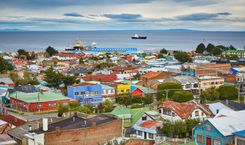
Built on a small promontory at the head of a 20km fjord, lively Castro occupies an unusual position both physically and historically. Founded in 1567, it’s the third-oldest city in Chile, but it never became strategically important because it’s a terrible harbour for sailing ships, only flourishing because the Jesuits chose to base their mission here. Today, little remains of old Castro, though some buildings have miraculously survived, such as the groups of brightly coloured palafitos – shingled fishermen’s houses on stilts – on the waterfront to the north and south of town.
Though deemed unsanitary by some locals, Chiloé’s famous palafitos are still found at several locations around Castro. Perched precariously on stilts above the water, these brightly painted, alerce-shingled, traditional wooden fishermen’s dwellings are an unforgettable sight. The idea was that you could moor your boat at your back door and walk out onto the street through the front one. The most impressive examples are found at the north end of town, off Pedro Montt, where they are perfectly reflected in the grubby mini-lake by the roadside. More palafitos are found slightly south along the same street, while others are used as restaurants at the southern end of town, by the Feria Artesanal. A final batch can be seen from the western end of Lillo, across the Río Gamboa and you can even stay in one.
Castro has had its fair share of difficulties through the centuries. It was sacked by the Dutch both in 1600 and then in 1643, destroyed by earthquake in 1646, by fire in 1729, by earthquake again in 1739, by fire again in 1890, by fire once more in 1936, and most recently by earthquake and tidal wave in 1960. Anyone else would have given up and moved long ago, but the Chilotes keep hanging on.
At the northwest end of Castro lies the Parque Municipal. In mid-February the park hosts an enormous feast, the culmination of the Festival Costumbrista, a celebration of traditional Chilote life, when curanto is cooked in great cauldrons, chicha (cider) flows freely and balls of grated potato – tropón – are baked on hot embers. The inevitable burnt fingers and resultant hot-potato juggling that results from picking them up is known as bailar el tropón (dancing the tropón).
On the island’s western coast, the Parque Nacional Chiloé comprises over 420 square kilometres of native evergreen forest, covering the slopes and valleys of the Cordillera de Piuchen, largely unexplored by man and harbouring flora and fauna unique to the archipelago, as well as wide deserted beaches and long stretches of rugged coastline, home to dozens of seabird species, penguins and sea lions. The park is divided into three sectors, as detailed below.
The most accessible of the three, Sector Anay, is reached by a 25km paved road that shoots west from a junction on the Panamericana, 20km south of Castro. At the end of the road is the gateway to the park, Chanquín – a scattering of houses across the bridge from the ramshackle village of Cucao, where you can buy last-minute provisions. Proper exploration of the park requires at least four days, but there are several nice walks that you can do in a day, staying overnight in Chanquín.
A couple of short hikes start from the visitor centre at the Conaf Ranger Post. The first is the circular, 770m “El Tepual”, running through an area of tepu forest, a tree which thrives in this humid bogland; there are log walkways across the wetter sections of these enchanted-looking woods, with twisted moss-covered trunks intertwined with other native species. The second hike is the Sendero La Playa, which leads you through patches of nalca (native rhubarb) and tunnels of dense vegetation before emerging on the regenerating scrubland that takes you via sand dunes to the exposed Pacific coast. A little more taxing is the 3km (one-way) walk along the beach to Lago Huelde, where you pick up a 9km trail known as Sendero Rancho Grande, along the Río Deñal up to the edge of the tree line, revealing beautiful views below.
The park’s longest hike is the beautiful 25km (6hr) Sendero Chanquín, which alternates between stretches of coastline, pounded by the fierce Pacific surf, and dense, native evergreen forest, before finishing up at the Conaf refugio at Cole Cole. There you’ll find a rustic campsite overseen by the Huentemó community, and a Conaf ranger post that is only open in the summer. You can also continue another 8km north to the Refugio Anay, though the trail is rather difficult, as there is currently no shuttle across the Río Anay.
Twenty-three kilometres south of Castro lies the attractive working town of Chonchi. Founded in 1767, the town thrived on timber exports and was home to the wood baron Ciriaco Alvarez, who earned the name El Rey de Ciprés (The Cypress King) by stripping the archipelago of almost all of its native forest. The most sheltered harbour on the island is lined with beautiful old wooden buildings, structures that have hardly changed since the eighteenth century, though the Mercado Municipal, which juts over the bay, is a new addition.
Calle Centenario, Chonchi’s steeply curving main street, leads down to a beach strewn with flotsam and jetsam, where you can see local women digging for razor clams at low tide. In February the town comes alive during the Semana Verano Chonchi – a folkloric festival featuring dancing, music, art and rodeo skills. Chonchi is also the home of the golden licor de oro, the potent concoction combining saffron, vanilla, milk, lemons, cloves, cinnamon and other ingredients to storm your palate.
On the coast, a 4km walk south of Chonchi at Huicha, a ferry heads to Isla Lemuy – a tranquil spot seldom visited by tourists. It’s dotted with traditional rural settlements, each boasting just a few houses and in some cases a fine old church. The most remote village of all is Detif, on an isolated, bleak headland at the far eastern end of the island, about 20km from Puqueldón, the island’s main settlement. The drive to Detif is particularly picturesque with the ocean on both sides of the road as you navigate the narrow strip leading to the headland.
The paved road to Queilén runs above a string of pretty little villages down by the sea. Tepua in particular is worth a visit to see its graveyard filled with mausoleos, traditional shelters that protect mourners from the elements when they visit the graves of the dead, some of which are splendidly ornate. You’ll either need a sturdy vehicle to tackle the steep dirt paths leading to the villages, or be prepared for a lot of walking.
Forty-six kilometres from Chonchi, the road pulls into Queilén, a sleepy little fishing town whose two main streets, Pedro Aguirre Cerda and Alessandri, bisect the neck of a long, sandy peninsula. The western end of town is very pretty, lined with fishermen’s houses built on a long beach sheltered by the nearby Isla Tranqui. In February the town hosts a craft fair in which all types of local products are sold, from handicrafts and farming equipment to traditional medicines.
If you follow Route 5 south from the turn-off for Chonchi, after 70km you reach QUELLÓN – the end of the Panamerican Highway, which spans almost the entire length of two continents, and the end of Chiloé. Formerly a logging port, Quellón is now a scruffy commercial fishing port of growing importance, with fishermen in rubber boots loitering around the pier. It’s based around three east–west streets that run parallel to the coast: the seafront costanera (Miramar and Pedro Montt); Ercilla, north of the costanera; and Ladrilleros, further north still. The main reason to come here is to catch a ferry across to Chaitén or down to Chacabuco, or to organize transportation to Parque Tantauco.
To the south of Isla Grande and to the west of Quellón lies Parque Tantauco, Chiloé’s largest natural attraction with nearly 1200 square kilometres of unspoiled wilderness, making it at least double the size of Parque Nacional Chiloé. The park, funded by the Fundación Futuro, is the brainchild of Sebastián Piñera, a Harvard-educated politician, self-made man and billionaire owner of LANChile, not to mention the current president of Chile.
After Douglas Tompkins unveiled Parque Pumalín, Piñera was inspired to start his own conservation project on Isla Grande. The project’s goal is to “protect and conserve vulnerable ecosystems and species, and those at risk of extinction”, as well as to restore a large chunk of the park’s territory that was devastated by a forest fire in the 1940s, by replanting native species in the affected area. The park is located in one of the world’s 25 “biodiversity hotspots”, with unique ecosystems and wildlife habitats, and home to such species as the Chilote fox, the pudú, the huillín (otter) and the blue whale.
Consisting of Zona Sur and Zona Norte, Tantauco boasts 150km of well-signposted hiking trails of varying length and difficulty, encompassing both the coastal areas and Chilote rainfores. These trails are part of a well-designed infrastructure that also includes fully equipped campsites and unmanned basic refugios. Owing to the park’s remoteness, moreover, it’s not overrun by day-trippers in the summer.
Though it’s possible to hike between Zona Norte and Zona Sur, the latter is otherwise only accessible by boat. You must allow four days to a week for the hike, bring all the necessary gear, including waterproof clothing, and inform the park authorities.
Top image © Shutterstock
Use Rough Guides' trusted partners for great rates
written by
Rough Guides Editors