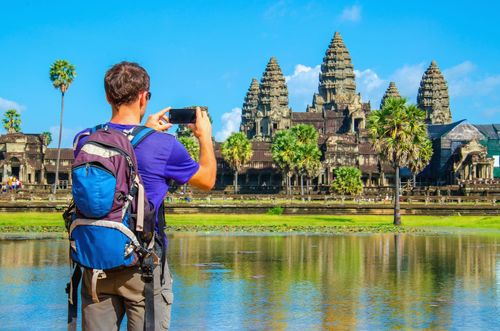
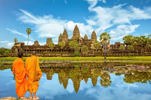
Eastern Cambodia Travel Guide

The wide-open spaces of Cambodia’s remote and sparsely populated east are a world away from the rest of the country, offering a quintessential slice of rural Khmer life largely unaffected by the modern world. Bounding the western side of the region, the mighty Mekong River forges its way south from Laos, dotted with river islands, dramatic stretches of flooded forest and the occasional floating village. Outside the main towns, much of the river remains largely off the tourist radar, although if you’ve got the time and energy there are myriad opportunities to explore the river and its rural hinterlands using a mix of boating, kayaking, cycling and walking.

East of the Mekong lie the distant highlands of Rattanakiri and Mondulkiri provinces. Rampant logging has taken a serious toll on these formerly pristine landscapes, although some jungle cover survives, providing a haven for wildlife – for the time being, at least. The highlands are also home to Cambodia’s chunchiet population who have traditionally eked out a subsistence living cultivating crops and foraging in the jungle. This centuries-old way of life is now threatened by the encroachment of the modern world and the loss of forest on which they depend.

Gateway to the region is the laidback Mekong-side town of Kompong Cham, a quiet provincial capital that retains an air of faded colonial gentility. Further north along the Mekong, Kratie is another old French-era settlement, best known for the rare Irrawaddy dolphins that inhabit the nearby rapids at Kampie. There are more dolphins to be seen at Stung Treng, the most northerly town on Cambodia’s stretch of the Mekong; this is also the starting point for rewarding tours of the beautiful surrounding countryside and for crossings into Laos. East of Stung Treng, Banlung, the capital of Rattanakiri province, is developing into a major centre for treks into the nearby highland jungles of the Virachey National Park and surrounding countryside. In the southeast of the region, tranquil Sen Monorom, the main town of Mondulkiri province, sees fewer visitors but offers further trekking and wildlife-spotting opportunities, as well as visits to some of the spectacular waterfalls that dot the area.

Border crossings in the East

Eastern Cambodia currently has four international border crossings: one with Laos, and three with Vietnam. All four are open daily from 7am to 5pm. Entering Laos and Cambodia, visas are issued on arrival (roughly $30–40 for a Lao visa, depending on your nationality; $20 for a Cambodian visa). Heading into Vietnam, you’ll need to have acquired a visa in advance, since none are issued at the border.

To Laos

Trapeang Kriel–Nong Nok Khiene Popular crossing 57km north of Stung Treng.

To Vietnam

O Yadaw–Le Tanh The most useful of the three border crossings into Vietnam, 70km east of Banlung along a good road. Guesthouses in Banlung sell through bus tickets from Banlung to the town of Pleiku, in the central highlands of Vietnam (around a 6–7hr journey from Banlung).

Trapeang Phlong–Xa Mat Little-used (and difficult to reach) crossing around 70km east of Kompong Cham.

Trapeang Sre–Loc Ninh Around 20km southeast of Snuol. This obscure crossing isn’t of much practical use given the lack of public transport on both sides of the border.

The chunchiet

Cambodia’s chunchiet (literally “nationality”) or Khmer Loeu (“upland Khmer”) are one of the ethnic minority groups found scattered throughout the hinterlands of Cambodia, Burma, Thailand, Laos, Vietnam and parts of southeastern China. The chunchiet live primarily in the remote villages of Rattanakiri and Mondulkiri provinces, although small communities also inhabit parts of Stung Treng and Kratie provinces, and a few live in the mountains of southwest Cambodia, near Koh Kong. It’s estimated that the chunchiet make up one percent of Cambodia’s population, although in the highlands of the east and northeast they have always been the majority, at least until the recent influx of Khmer from the rest of the country.

The chunchiet, like the Khmer, are regarded as indigenous inhabitants of the country. Smaller in stature and darker-skinned than the Khmer, they divide into more than thirty distinct tribes, ranging from comparatively large groups such as the Tampoun, Kreung-Brou, Jarai, Stieng and Phnong, all of which number in the thousands, to much smaller tribes, including the Kavat, Lun, Peahr and Meul, which are believed to number fewer than a hundred each. Every group has its own language, each with several dialects; additionally, none of the chunchiet tongues has a written form. Traditional garments are used only on ceremonial occasions, from which strangers are normally excluded. Indeed, relatively little is known about chunchiet rituals and ceremonies, though it is known that animism and ancestor worship are central to the chunchiet belief system.

Unfortunately, the traditional way of life is now nearly extinct. Repeated attempts have been made to bring the tribes round to the Khmer way of life. The French recruited them to work in the rubber plantations and on road-building projects, while the Sihanouk government tried to restrict them to farming fixed plots. In the mid-1960s, government troops seeking the guerrilla Khmer Rouge – who had fled to the jungles of Rattanakiri – burned down chunchiet villages. Indeed, bombed by the US in the early 1970s and continually harassed by Lon Nol soldiers, the chunchiet were ripe for recruitment by the Khmer Rouge, although those who did join them were most likely siding with them against a common enemy rather than sharing their ideology.

Today, in theory, chunchiet lands are state-owned and cannot be sold to private Cambodians, but since 2001 tribal lands have been sold, sometimes by village headmen, to savvy Khmer who have cleared the land for farms. Latterly, the government has allowed economic land concessions (ELCs), which permit ground to be cleared for plantations. According to Cambodian law, ELCs can only be used to clear non-forested land, but regardless of this, vast swathes of forest have now been cleared to make way for plantations of rubber and cashew; according to a report by Global Witness (see Illegal logging) this is a way of flouting the rules regarding illegal logging. The consequence for the chunchiet is that the forest on which they have long relied for their livelihood has been largely destroyed. Appeals for the return of their land has been to no avail. Some still manage to eke a living out of the land, others have found work locally in tourism, while some have been forced to abandon their traditional way of life entirely.

Although many villagers have become accustomed to foreign visitors, they remain shy and modest – some may even see your presence as voyeuristic, so it’s always better to visit in the company of a local guide. It’s also worth noting that the chunchiet do not like having their pictures taken and are embarrassed by shows of public affection and by exposed flesh (bare legs, arms and so on).

Kompong Cham

Situated on the west bank of the Mekong, the mellow town of KOMPONG CHAM has little of the bustle that you’d expect of the biggest city in eastern Cambodia. Its small commercial port doesn’t exactly hum with activity, and the riverfront, in the shadow of the massive Kizuna Bridge, is pretty quiet too since road improvements have led to the demise of most river transport. The town’s attractive backwater somnolence belies its more energetic past. In the 1930s and 1940s, Kompong Cham – named after the sizeable population of local Cham Muslims – was a prosperous rubber and tobacco trading centre and the most cosmopolitan town in Cambodia. You can sense some evidence of its previous affluence in the wide, tree-lined streets and the faded shophouses and warehouses lining the waterfront.

Today’s town has a distinct charm, and it’s easy to while away a day meandering through the unhurried streets, taking in the faded colonial architecture (particularly around the market) and visiting the remains of the venerable Wat Nokor just outside town – as well as enjoying the convivial riverfront cafés, busy in the evenings with tourists stopping over on a slow journey through the country. In half a day you can follow the Mekong north to Phnom Hann Chey, a quirky hilltop temple with fabulous views of the river, while a day-trip will get you to the pre-Angkorian site of Banteay Prei Nokor, home to a few ruined towers surrounded by a massive earth embankment. Enjoyable boat trips can also be made to villages up and down the Mekong.

Kompong Cham food and drink

There’s an excellent little cluster of restaurants and cafés along the waterfront. Food stalls can be found around the transport stop and market, while late in the afternoon further stalls set up along the riverfront. The tourist-oriented riverfront restaurants are usually fairly lively after dark, although most places usually shut up promptly at 10pm.

River trips around Kompong Cham

There are several interesting places within the vicinity of Kompong Cham that can be reached by boat and make for a rewarding day out if there are a few of you to share the cost – although note that most of these sites can also be reached more cheaply by moto or tuk-tuk. Trips can be arranged through Mekong Crossing, with possible destinations including Wat Maha Leap (about 20km south of Kompong Cham), an old wooden building with gilded teak columns; Prei Chung Kran village (just upstream from Maha Leap temple on the Tonle Tuok), where silk is woven on traditional hand looms; and Wat Hann Chey, about 20km north of Kompong Cham, where there are fantastic river views from Chenla-era ruins and a modern temple.

Around Kompong Cham

Several low-key sights dot the area around Kompong Cham. Glimpses of traditional Mekong life can be had close to town on the idyllic Koh Pbain river island, while it’s well worth making the short trip out to the edge of town to visit Wat Nokor, a fine old temple with quirky modern additions, and the hilltop religious complex of Phnom Bpros Phnom Srei.

The Cham

Originating from the kingdom of Champa, which formerly extended from Hue to Phan Thiet on the coast of present-day Vietnam, the Cham are the largest minority ethnic group in Cambodia, numbering in the region of 250,000 (estimates vary) and accounting for about a third of the country’s non-Khmer population. They also represent Cambodia’s largest minority religion, being Sunni Muslims who converted from Hinduism some time after the fourteenth century.

Historically, the Cham were frequently at war both with the Khmer, who bordered their kingdom to the west and south, and the Vietnamese, who occupied the territory to the north. In 1177, the Cham successfully raided Angkor, only to be defeated by the intervention of Jayavarman VII in a ferocious battle on the Tonle Sap – an event depicted in the bas-reliefs at the Bayon temple. By the end of the seventeenth century, however, the gradual whittling away of its territory by the Vietnamese meant that Champa had effectively ceased to exist, and many Cham fled to Cambodia. The traditional Cham – who retain many of the old beliefs and rituals, but acknowledge non-Islamic gods – make up about two-thirds of Cambodia’s Cham population. They settled around the Tonle Sap, along the central rivers, and in what is now Kompong Cham province. The orthodox Cham, who are more similar to Muslims in other Islamic countries, settled around Oudong, Kampot and Takeo. Establishing their own villages, they took up fishing, breeding water buffalo, silver-working and weaving, activities that the vast majority still practise today. Their villages can easily be identified by the presence of a mosque and Islamic school, and by the absence of pigs.

The Cham have generally coexisted peacefully alongside the Khmer throughout their history, despite speaking their own language (Cham) and maintaining separate traditions. Only under the Khmer Rouge did they suffer significant persecution: easily picked out thanks to their Islamic dress and distinctive features (they seldom marry outsiders), many Cham were either massacred or persecuted – often by being forced to eat pork – and their mosques destroyed.

Kratie and around

Seventy kilometres north of Kompong Cham on the east bank of the Mekong, KRATIE (pronounced Kra-cheh) has become a popular tourist destination thanks to the rare Irrawaddy dolphins that inhabit the river upstream at nearby Kampie. Dolphin-watching trips can also be easily combined with a visit to the lovely hilltop meditation centre of Phnom Sambok and the temple and turtle conservation project at Sambor, further upriver, while the chance to explore nearby river islands, go kayaking or head off along the Mekong Discovery Trail may tempt you to linger longer.

Dolphins and other attractions aside, Kratie itself makes a pleasant spot to rest up for a night or two, with a decent clutch of hotels and some good restaurants lined up along the serene riverside. Parts of the town still retain vestiges of their old French colonial architecture, including the fine old Governor’s Residence, just south of the centre (now signed as the Provincial Council Kratie).

Kampie

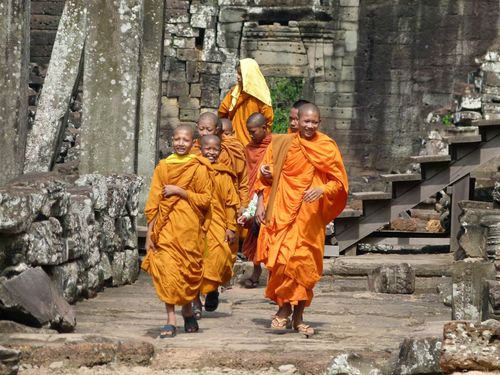
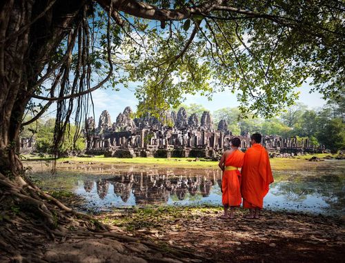
Cambodians traditionally believe that the Irrawaddy dolphins (psout) that live around the Mekong rapids at KAMPIE are part human and part fish, and consequently do their best to look after them. Despite this, the dolphins’ numbers have declined sharply due to the use of explosives and electric rods for fishing, and in 2004 the Irrawaddy dolphin was added to the IUCN Red List as a critically endangered species.

The dolphin-watching site is now run as an ecotourism project by the local community. Having purchased your ticket you’ll be loaded into a boat for the trip (lasting roughly 1hr during the Nov–May dry season; closer to 1hr 30min during the wet season, when the dolphins travel further downriver). Once boats are out on the water in the vicinity of the dolphins the motor is cut and boatmen row their craft to create the minimum of disturbance. The dolphins are most active during the early morning and late afternoon, when they tend to feed, although sightings are pretty much guaranteed at any time. They’re fairly easy to see (albeit almost impossible to photograph) and even easier to hear thanks to the characteristic noise they make (like the sound of someone taking a sudden deep breath through a large tube) when breaking the surface of the water to take in air.

It’s also possible to see the dolphins from dry land. Continue to the stretch of open riverbank about 1km north of the centre, from where sightings are possible.
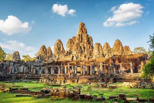
Irrawaddy dolphins

Freshwater rivers, such as the Irrawaddy and Mekong in Southeast Asia, and the shallow tropical zones of the Indian and Pacific oceans, constitute the habitat of the Irrawaddy dolphin (Orcaella brevirostris). In the Mekong they now inhabit just a 190km stretch in the north of Cambodia, and can be spotted most easily at Kampie and north of Stung Treng near the Laos border, with occasional sightings elsewhere. In 2001, a pair were found just a few kilometres north of Phnom Penh.

Irrawaddy dolphins look more like porpoises than marine dolphins, with rounded heads and foreheads that protrude slightly over a straight mouth; noticeably, unlike their seagoing cousins, they have no beak. They’re also more languid than their marine cousins, rarely leaping out of the water, chasing after boats or displaying any of the other skittish personality traits commonly identified with their species.

Irrawaddy dolphins reach maturity around the age of 5 years, when they can measure up to 2.75m in length and weigh up to 200kg. Family groups, or pods, usually consist of around six individuals, but larger groups are not unknown. In spite of good breeding rates, there is a high rate of calf mortality, which remains unexplained.

Mekong Discovery Trail

Covering the stretch of the Mekong between Kratie and the Laos border north of Stung Treng, the Mekong Discovery Trail is an initiative to get tourists off the beaten track and experience the river’s rich culture, ecology and historical heritage. The so-called “trail” actually comprises ten separate itineraries using existing roads, tracks and waterways – a few signs have been set up along some of the routes, but most of the time you’ll have to find your own way.

The itineraries themselves are something of a moveable feast – most can be explored using a mix of transport depending on what suits, whether on foot, by bike, or using a tuk-tuk or car. A few also include the possibility of an overnight homestay en route. The various routes are covered in more detail in a useful leaflet that you may be able to pick up in Kratie or from Xplore Asia in Stung Treng, who also arrange guided tours around parts of the trail. The following is a brief summary.

  • Ancient Ruins of Thala Barivat Trail 3km round-trip from Stung Treng to the ancient temple ruins at Thala Barivat.
  • Bamboo Sticky Rice and Bridges 9km round-trip from Stung Treng featuring Sekong views and krolan (sticky bamboo rice) tasting at Hang Khou Ban village.
  • Distant Dolphins Trail 40km by bike, or 61km by motorbike from Stung Treng to a beautiful, rarely visited stretch of the Mekong, including the dolphin pool at Damrei Phong, south of Stung Treng, and Koh Preah river island.
  • Dolphin and Krolan Discovery Trail 16km one way from Kratie, including the dolphin-watching site at Kampie and Phnom Sambok temple.
  • Koh Trong Island Trail 9km round-trip around the river island of Koh Trong, just outside Kratie.
  • Kratie Architecture and Alms Trail 7km round-trip tour of Kratie, including the market, Wat Roka Kandal and Wat Serey Santhor Vong.
  • River Life Explorer Trail 44km round-trip from Kratie, following the little-visited west bank of the Mekong from Kratie to Kampie and beyond.
  • Stung Treng Silk and Sunset Trail 7km round-trip from Stung Treng, including a visit to the Mekong Blue silk-weaving centre.
  • Wat Sarsar Mouy and Koh Pdao Trail 35km from Kratie to Sambor, plus 15km around Koh Pdao river island.
  • Waterfalls, Wetland and Wildlife Trail 57km from Stung Treng to O Svay, including visits to the Sopheak Mitt falls and Anlong Cheuteal dolphin pool.

Mekong homestays

Cambodian Rural Development Tours (crdt.org.kh) runs a number of homestay opportunities along the Mekong, offering one- or two-night stays at a trio of villages up and down the river and allowing visitors a rare chance to experience traditional Cambodian rural life from the inside.

  • Koh Pdao Just north of Sambor (and 40km north of Kratie). One- or two-night homestays on this peaceful river island, including visits to the nearby turtle conservation centre, the hundred-pillar pagoda and the dolphins at Kampie.
  • Koh Preah Village 35km from Stung Treng. Visits include cycling along the Mekong, the chance to sample traditional Khmer village food, a visit to the local dolphin pool and chats with village elders.
  • Preah Rumkel North of Stung Treng near the Laos border. Visits include kayaking, cycling and dolphin-spotting.

Tours around Kratie

Tours can be arranged through most guesthouses and hotels in Kratie – try either of the two U Hong guesthouses or the Tokae restaurant.

CRDT (Cambodian Rural Development Tours) crdtours.org. Various tours and homestays up and down the Mekong, with several in and around Kratie including Kampie, Sambor, Koh Trong island and tours of Kratie town itself.

Sorya Kayaking Adventures soryakayaking.com. The perfect way to see the Mekong without the roar of an outboard boat engine disturbing the peace. Half-day trips include dolphin-spotting at Kampie and visits to the Mekong Island of Koh Trong, plus one- and two-day excursions on the Te River including visits to floating ethnic Vietnamese villages and the chance to paddle through beautiful stretches of flooded Mekong River forest en route.

Stung Treng

Situated on the Sekong River 140km north of Kratie (and a similar distance west of Banlung), the tranquil little town of STUNG TRENG is a bit of a backwater. For most visitors the town is simply a staging-post en route to Laos, although the construction of a huge new Mekong bridge nearby, connecting with a new road to Tbeang Meanchey and then on to Siem Reap, may help revitalize the town’s fortunes, opening up new routes between central Cambodia and the northeast, and establishing Stung Treng as an alternative gateway to the region.

There are various attractions in the countryside surrounding Stung Treng, too, many of them covered by the Mekong Discovery Trail. It is also the jumping-off point for the splendid river trip along the Mekong to the Laos border, with glimpses of rare Irrawaddy dolphins and thundering waterfalls en route.

Tours around Stung Treng

There are a number of attractions around Stung Treng: the widest range of local tours is run by Xplore Asia, but there are other options available.

Riverside Guesthouse Tours This guesthouse is a good option for boat trips, either up the Mekong to the Laos border and back or along the narrower Sekong.

Xplore Asia xplore-cambodia.com. A good range of interesting, albeit pricey, trips, including a grand four- to five-day journey down the Mekong to Kratie that takes in parts of the Mekong Discovery Trail using a combination of cycling, trekking and kayaking. More affordable excursions include one-day trips combining kayaking, trekking and dolphin watching; a full day’s kayaking; half-day cycling and kayaking trips; and fishing trips. They can also arrange boat trips to the Sopheak Mitt falls, dolphin watching and a spectacular stretch of flooded forest.

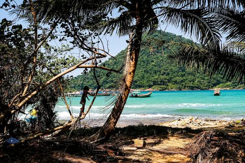
Along the Mekong: Stung Treng to Laos

The stretch of Mekong between Stung Treng and the Laos border is rich in ecotourism potential, most of it still largely untapped. River islands, waterfalls, rapids and impressive stretches of flooded forest dot the waters, culminating in the thundering Sopheak Mitt waterfalls, which block the route on into Laos.

As at Kratie, pods of Irrawaddy dolphins are the major draw, and can be found at several spots along the river. Most visitors head for the so-called Anlong Cheuteal dolphin pool, just south of the Laos border. Boat trips here can be arranged at Stung Treng; alternatively, you may be able to arrange a boat (roughly $15/hr) at the nearby villages of O Svay and Preah Rumkel – homestays can also be arranged at the latter. Dolphin numbers are smaller here than at Kampie, although there’s still around a ninety percent chance of spotting them.

Rattanakiri province

Bordering Laos and Vietnam in the far northeast corner of Cambodia, the province of Rattanakiri used to abound in lush jungle. These days most of the region’s ancient forests have been systematically logged of their valuable hardwoods and replanted with cash-crop plantations, mainly rubber, cashew and cassava, although the vistas of misty mountains and gushing waterfalls remain, if nothing else. As befits a province whose name means “gemstone mountain”, traditional gem-mining also survives amid the hills, a difficult and dangerous activity, with miners dragging soil to the surface from deep holes where it is painstakingly sifted for the gems you see in every Cambodian market.

Banlung

Situated 588km from Phnom Penh by road, the small provincial capital of BANLUNG feels a long way from the rest of Cambodia – and indeed from anywhere else. The town sprang to prominence in 1979 when it was chosen as the new provincial capital of Rattanakiri, replacing Voen Sai. Significant development followed (and continues to this day), although Banlung hasn’t altogether shaken off its Wild West atmosphere. Most of the town’s formerly dirt tracks have now been roughly surfaced but are so indelibly stained with red dirt and mud as to resemble outback tracks, especially after rain, while the combination of local chunchiet descending on town to visit the lively market and marauding touts attempting to flog treks to the unwary add to the place’s slightly chaotic appeal. It’s also notably cooler up here than down in the lowlands (for once, hot showers are more important than air conditioning), while the town also experiences significantly more rainfall than most other places in the country.

Most people come to Banlung to trek, and there are also a number of interesting day-trips in the surrounding countryside. The town itself is pretty much devoid of attractions, bar the lively local market and the tranquil lake of Boeung Kansaing.

Mondulkiri province

The country’s largest but most sparsely populated province, mountainous Mondulkiri sees fewer travellers in a year than Rattanakiri does in a month, although improved access is gradually bringing Cambodia’s “Wild East” into the tourist mainstream. As in neighbouring Rattanakiri, Mondulkiri’s once wild landscape has suffered greatly from indiscriminate logging and other forms of development, including the creation of Chinese and Australian gold mines, although areas of impenetrable jungle survive, home to rare and endangered wildlife including elephants, Asian dogs and green peafowl. The compact provincial capital, Sen Monorom, makes a good base for local treks and visits to surrounding attractions, including the mighty Bou Sraa waterfall and the innovative Elephant Valley Project.

Mondulkiri’s main indigenous group are the Bunong (also known as the Phnong), who made up nearly eighty percent of the province’s population until the 1990s, when they were joined by an influx of impoverished Khmer returning from the refugee camps in Thailand. The Khmer are still coming, though nowadays it’s rich ones who are buying land cheaply then clearing it for farms and plantations.

Sen Monorom

SEN MONOROM is still little more than a large village set amid a landscape of rolling grass-covered hills – more reminiscent of England than Cambodia – dotted with copses of pine planted in the late 1960s at the king’s behest. The two lakes close to town are pleasant for an early morning or late afternoon stroll, while 2km northeast from town is the sacred mountain Phnom Dosh Kramom (known as Youk Srosh Phlom to the Bunong), a small hill with a meditation pagoda, from which there are splendid views.

Trekking in Sen Monorom, although not yet as big as in Banlung, is becoming increasingly popular, with a variety of routes lasting from a day to a week. The best operators use Bunong guides, who intimately know the forests through which you’ll be walking. Treks generally include a mix of cultural and scenic attractions, with visits to Bunong villages and waterfalls along with jungle hiking and wild swimming.

Waterfalls around Sen Monorom

Cambodia’s most dramatic cascade, Bou Sraa waterfall is a fabulous two-tiered cascade some 35km from Sen Monorom, towards the Vietnamese border. The setting alone makes the falls worth visiting, the river dropping over 30m into a jungle gorge. Getting there is something of an expedition, however, making it easy to see why the locals get around by elephant. Not nearly as dramatic as Bou Sraa, but a whole lot easier to get to (though the road is unsurfaced and can be tricky after rain), are the three-tier Romanea falls.

Just 4km northwest of Sen Monorom is the 10m-high Monorom waterfall (also known as the Sihanouk falls). Along the way you’ll pass the ruins of the (rarely used) royal residence, after which you should follow the left fork to the falls. You can swim in the pool at the base of the falls, even in the dry season.

The Elephant Valley Project

A place where “Elephants get to be elephants again”, the innovative Elephant Valley Project was set up to create a haven for Cambodia’s increasingly threatened pachyderm population. The project is the complete antithesis of the usual tourist theme-park, with all the animal exploitation it inevitably entails. There are no elephant rides here (something the project actively discourages). Instead, visitors get the chance to shadow the project’s ten resident elephants, walking with them through the jungle and observing them at leisure in their natural environment, while also learning about them from the local indigenous Bunong guides and mahouts.

The project is part of the Elephant Livelihood Initiative Environment NGO or ELIE, for short, which works to improve the welfare of the captive population of elephants in Mondulkiri and across Cambodia, many of whom suffer overwork, malnutrition and abuse. ELIE runs several projects locally, including an elephant research and monitoring programme and a mobile vet service.

Top image: Nokor Bachey Pagoda, Kampong Cham, Cambodia © Sergei Mugashev/Shutterstock

Planning your own trip? Prepare for your trip

Use Rough Guides' trusted partners for great rates

Andy Turner

written by
Andy Turner

updated 26.04.2021

Ready to travel and discover
Cambodia?

Get support from our local experts for
stress-free planning & worry-free travels

Plan my trip ⤍