The Picos de Europa

The Picos de Europa may not be the highest mountains in Spain, but they’re the favourite of many walkers, trekkers and climbers. Declared a national park in its entirety in 1995, the range is a miniature masterpiece: a mere 40 km across in either direction, shoehorned in between three great river gorges, and straddling the provinces of Asturias, León and Cantabria. Asturians see the mountains as a symbol of their national identity, and celebrate a cave-shrine at Covadonga in the west as the birthplace of Christian Spain.

Walks and hikes at the Picos de Europa

Walks in the Picos are amazingly diverse, with trails to suit all levels, from a casual morning’s stroll to two or three-day treks. The most spectacular and popular routes are along the 12 km Cares Gorge – which you can take in whole or part – and around the high peaks reached from the cable car at Fuente Dé and the subterranean funicular railway at Poncebos, though dozens of other paths and trails explore the river valleys or climb into the mountains. Take care if you go off the marked trails: the Picos can pose extreme challenges, with unstable weather and treacherous, unforgiving terrain, and what appears from a distance to be a slowly undulating plateau can too easily turn out to be a series of chasms and gorges.

When to visit the Picos de Europa

As road access has opened up the gorges and peaks, the Picos have been brought increasingly into the mainstream of tourism, and the most popular areas get very crowded in July and August. If you have the choice, and are content with lower-level walks, spring is best, when the valleys are gorgeous and the peaks still snowcapped, although the changing colours of the beech forests in autumn give some competition.

High mountains trekking two people Picos de Europa Cantabria Spain

Hiking at Picos de Europa © Miguel Castans Monteagudo / Shutterstock

Getting to the Picos de Europa

You can approach – and leave – the Picos along half a dozen roads: from León, to the south; from Santander and the coast, to the north and northeast; and from Oviedo and Cangas de Onís, to the northwest. Public transport serves much of the park, but services are generally infrequent, even in summer.

Book tour the Picos and Potes guided tour from Santander

Book tour the Picos de Europa guided walking tour and spa circuit in La Hermida

Covadonga

High in the northern Picos, the pilgrimage site of Covadonga is renowned as the place where the Reconquist of Spain began. Squeezed between enormously steep slopes, it’s a stupendous spot, centring on a cave set into a high cliff face, from immediately below which a powerful waterfall spurts forth. It lies 5km up a spur road that parallels the Río Reinazo south into the mountains, 4km east of Cangas de Onís, or 28km west of Arenas de Cabrales.

According to Christian chronicles, in 718, the Visigothic King Pelayo and a small group of followers repelled the Moorish armies here at odds of 31 to 400,000. While the reality was slightly less dramatic, the Moors being little more than a weary and isolated expeditionary force, the symbolism of the event is at the heart of Asturian, and Spanish, national history, and the defeat allowed the Visigoths to regroup, slowly expanding Christian influence over the northern mountains of Spain and Portugal.

Although overwhelmed with tourists in summer, Covadonga remains a serious religious shrine. There’s no village here, just a cluster of buildings dominated by a grandiose nineteenth-century pink-granite basilica that’s more impressive from the outside than in. Alongside, the Museo de Covadonga (daily 10.30am–2pm & 4–7pm; €2.50) displays assorted paintings and engravings.

A short walk leads through cliff-face shrines to the cave itself (Mon–Fri 10am–6pm, Sat 9am–6pm; free). Daily Mass is celebrated in the stone chapel at the far end, next to Pelayo’s sarcophagus.

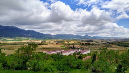
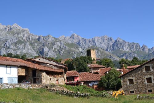
Hiking in the eastern Picos: from Espinama and Fuente Dé

The best starting point for hikes into the mountains from the Picos’ eastern side has to be Espinama, though if you’re at all pressed for time, taking the cable car up from Fuente Dé and then hiking back down to Espinama (10km; 3–4hr) makes a quick and relatively pain-free alternative.

A superb trek (12.5km; 5hr) follows a dirt track (also passable in 4WD vehicles) from Espinama to the village of Sotres, 8km east of Poncebos. Setting off north from Espinama beneath an arching balcony alongside the Peña Vieja bar, the track climbs stiffly, winding past hand-cut hay fields and through groups of barns, until tall cliffs rise on either side to form a natural gateway. Through this you enter a different landscape of rocky summer pasture and small streams. As you near the highest point, 4.5km or perhaps two hours along, the track divides at a small barn; the left-hand path leads up to the Refugio de Aliva and the top of the cable car, but for Sotres you should continue straight ahead, past a chapel (visible from the junction), up to the ridge forming the pass.

Over the divide the scenery changes again, into a mass of crumbling limestone. In spring and winter, the downhill stretch of track here is slippery and treacherous to all but goats. From the foot of the hill, where a seasonal bar sells drinks, you’ll have to climb slightly once again to the east to reach Sotres itself, which, when it appears, has a grim, almost fortified feel, clinging to a cliff edge above a stark green valley. Alternatively, a zigzag climb to the west marks the start of the 5km route (around 2hr) to the more appealing village of Bulnes.

Hiking in the southern Picos: the Cares Gorge

Deservedly the most popular walk in the Picos takes hikers into the heart of the central massif, along the Cares Gorge (Desfiladero de Cares). Its most enclosed section, between Caín and Poncebos – a massive cleft more than 1000m deep and some 12km long – bores through awesome terrain along an amazing footpath hacked out of the cliff face. Maintained in excellent condition by the water authorities, it’s perfectly safe. Many day-trippers simply get a taste of it by walking as far as they choose to and from Caín, but with reasonable energy, it’s perfectly possible to hike its full length – in both directions – in well under a day.

The gorge proper begins immediately north of Caín. Just beyond the end of the road, the valley briefly opens out, but then, as you follow the river downstream, it suddenly disappears – a solid mountain wall blocks all but a thin vertical cleft. In its early stages, the trail burrows dramatically through the rock, before emerging onto a broad, well-constructed and well-maintained footpath, which owes its existence to a long-established hydroelectric scheme. During busy periods, the first few kilometres of the trail tend to be thronged with day-trippers thrilling at the dripping tunnels and walkways. Once you get 4km or so from Caín, however, the crowds thin out, and the mountains command your total attention. They rise pale and jagged on either side, with griffon vultures and other birds of prey circling the crags. The river drops steeply, some 150m below you at the first bridge, but closer to 300m by the end.

A little over halfway along, the canyon bends to the right and gradually widens along the descent to Poncebos. Roughly 7km and 9km into the gorge, enterprising individuals run makeshift, summer-only refreshments stands, handy as there are no springs. For its final 3km, the main route climbs a dry, exposed hillside; an alternative riverside path can be reached by a steep side-trail that zigzags down the precipice.

It is, of course, equally possible to walk all or part of the gorge from the north, starting at Poncebos.

Wildlife in the Picos

Wildlife is a major attraction in the Picos de Europa. In the Cares Gorge, you may well see griffon vultures, black redstarts and ravens, though birdwatchers keep a special eye out for the red-winged, butterfly-like flight of the diminutive wallcreeper, named for the mouse-like way it creeps along the vertical cliff faces. Wild and domestic goats abound, with some unbelievably inaccessible high mountain pastures. Wolves are easy to imagine in the grey boulders of the passes, but bears, despite local gossip and their picturesque appearances on the tourist-board maps, are very seldom spotted. An inbred population of about a hundred specimens of Ursus arctos pyrenaicus (Cantabrian brown bear) remains in the southern Picos, most of them tagged with radio transmitters; another isolated group survives in western Asturias.

Hiking in the northern Picos: from Poncebos and Sotres

For visitors based on the northern flanks of the Picos, Poncebos and Sotres are the best spots from which to start hiking. As well as being the northern trailhead for the Cares Gorge, Poncebos also lies at the foot of the path up to Bulnes. Allow roughly 1hr 30min for that climb, which branches east from the Cares Gorge trail 1km south of Poncebos, across the photogenic medieval bridge of Jaya. While it’s not a hard slog, you’re better off taking the funicular if you have problems with vertigo.

Car-cable. Picos de Europa mountains, Cantabria (Spain).

Cable Car in the Picos de Europa © Denis Zhitnik / Shutterstock

Sotres, 9km east of Poncebos along the narrow CA 1, is not one of the more attractive Picos villages, but it lies at the northern end of the ravishing 12.5km hike from Espinama, and thus makes a good overnight halt for walkers heading right across the central Picos. A direct trail connects Sotres with Bulnes in just 5km, by way of the broad, windy pass of Pandébano (which, with care, can also be reached along primitive roads by car). The high meadows at the top are still used for summer pasture by villagers from Bulnes, some of whom spend the summer there in simple stone dwellings. An old, steep, cobbled path leads down to Bulnes itself.

From both Bulnes village and the pass at Pandébano, well-used paths lead up to the Vega de Urriello, the high pasture at the base of the Naranjo de Bulnes (2519m). An immense slab of orange-hued rock, the Picos’ trademark peak stands aloof from the jagged grey sierras around it. The approach from Pandébano is easier, a two- to three-hour hike along a track that passes the small refugio of Terenosa (t985 252 362; no food; closed Oct–April). The direct path up from Bulnes is heavy going, and can take up to six hours in bad conditions, with a slippery scree surface that’s very difficult, and dangerous when wet. Once up on the plateau, you’ll find another refugio, the Vega de Urriello, at an altitude of 1953m (t985 925 200), and a permanent spring, as well as large numbers of campers and rock climbers, for whom the Naranjo is a popular target.

Experienced trekkers can stay the night in the Vega de Urriello refugio and then continue across the central massif, through a roller-coaster landscape unforgiving of mistakes, to the Cabaña Veronica refugio, which is for emergency use only, and has just three bunks. An easy descent from there brings you to the top of the Fuente Dé cable car. Alternatively, you can continue west through further challenging terrain to another refugio at Collado Jermoso (t636 998 727, wwww.colladojermoso.com) before dropping down the ravine of Asotín takes you finally to Cordiñanes at the top of the Cares Gorge. The trek from Vega de Urriello should only be undertaken in a group equipped with proper maps and gear.

Featured Image, Picos de Europa © Javier Rosana / Shutterstock

Planning your own trip? Prepare for your trip

Use Rough Guides' trusted partners for great rates

Rough Guides Editors

written by Rough Guides Editors

updated 27.04.2021

Ready to travel and discover
Spain?

Get support from our local experts for
stress-free planning & worry-free travels

Plan my trip ⤍