Brief history of the Free State
Intriguing though it sounds, the name “Free State” applies to former redneck country. For nearly 150 years, the only free people in the Free State were its white settlers, who in 1854 were granted independence from Britain in a territory between the Orange and Vaal rivers, where they created a Boer Republic called the Orange Free State. The “Orange” part of the name came from the royal Dutch House of Orange. The system of government in the republic, inspired by the US Constitution, was highly democratic – if you were white and male. Women couldn’t vote, while Africans had no rights at all, and were even forbidden from owning land. In 1912 the ANC was formed in the Bloemfontein township of Batho, while the Nationalist Party was founded two years later in Bloemfontein itself. In 1914, the Orange Free State became a bastion of apartheid, being the only province to ban anyone of Asian descent from remaining within its borders for longer than 24 hours. Africans fared little better; in 1970, under the grand apartheid scheme, a tiny barren enclave wedged between Lesotho, KwaZulu-Natal and the Free State became QwaQwa, a “homeland” for Southern Sotho people – a result of forced clearances from white-designated areas. The Bantustans have since been reincorporated into South Africa and, after an ANC landslide in Free State province in the 1994 elections, the “Orange” part of the name, with its Dutch Calvinist associations, was dropped.
The Maloti Route
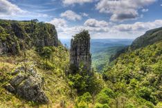
Hugging the Lesotho border for 280km from Phuthaditjhaba (Witsieshoek) in the north to Wepener in the south, the tarred Maloti Route offers one of South Africa’s most scenic drives, taking you past massive rock formations streaked with red and ochre, cherry orchards and sandstone farming towns. Wedged into a corner between Lesotho and northern KwaZulu-Natal, Phuthaditjhaba is the gateway to the Sentinel, from where it’s easy to hike the Drakensberg Escarpment. Not far to the west is the highlight of the region, the Golden Gate Highlands National Park, encompassing wide-open mountain country. The park is an easy three- to four-hour drive from Johannesburg, which means you could easily use it as a first- or last-night stop if you’re arriving or leaving from Johannesburg and don’t want to spend the night in the city. Nearby, the Basotho Cultural Village is worth visiting to gain some insight into Basotho traditions. The closest village to the Golden Gate Park is Clarens, a centre for arts and crafts and the most attractive of all the villages along the route.
Basotho Cultural Village
The Basotho Cultural Village is a great place to learn about the traditional lives of the Basotho people, who have lived in the vicinity and just across the border in Lesotho for centuries. The main display in the reconstructed village is a courtyard of beautiful Basotho huts, from organic circular sixteenth-century constructions to square huts with tin roofs, bright interior decor and European blankets and utensils. Visitors are taken on a tour run by actors in traditional dress, meeting the chief, sampling traditional beer, hearing musicians play and seeing a traditional healer; you also learn about the curious spiral aloe, plants unique to the Drakensberg.
The views across the surrounding QwaQwa Nature Park are awesome, and there’s an endless choice of walks and pony rides. The curio shop sells some quality local crafts (look out for raffia mats and baskets and the conical hats unique to this area), and the open-air tea garden serves teas and traditional food.
You can stay the night here in some traditional Basotho rondavel huts with views over the plain.
Hiking up the Drakensberg Escarpment
South Africa’s most spectacular mountain views are from the Drakensberg Escarpment, the high plateau above the major peaks, and from the top of the Amphitheatre, the grand sweep of cliffs that dominates Royal Natal National Park. Reaching them from KwaZulu-Natal demands a high level of fitness, but the route from the Sentinel car park in the Free State makes the ascent more manageable. From Mahai campsite in Royal Natal National Park, it’s a tough ten-hour climb; from Sentinel, a 2.5-hour walk brings you to the foot of a 30m-high chain ladder rising up an almost vertical rock face.
At the top, a final short push leads to the escarpment’s highest point, at 3278m, with vast views across the Berg. This can be a memorable highlight on 7-day South Africa trips with a strong hiking focus, adding high-altitude drama to an itinerary built around the country’s wilder landscapes. Don’t be lulled by the apparently easy approach from Sentinel: the Berg has a habit of having the last word. Always tackle the ladder with enough food, water, warm clothes, and a tent in which to wait out violent storms, and set out early so you have the whole day for the excursion.
For those bitten by the mountain bug, some serious hikes are available, including a two-week trek along the escarpment plateau to Sani Pass in the southern Drakensberg. You can also take in the most dramatic parts of the Berg on a five-day, 62km escarpment traverse, sleeping in caves, from the Sentinel car park to Cathedral Peak in the Natal Drakensberg Park, roughly 40km to the southwest. For any hikes of this nature you’ll need a map and the excellent Best Walks of the Drakensberg by David Bristow, available in most bookshops.
Parys and the Vredefort Dome
The small town of PARYS, just off the N1 highway 300km northeast of Bloemfontein and 100km from Johannesburg, makes a good stopover on the long trek across the country, or an interesting day-trip from Jo’burg. The town, with its galleries, antique shops, adventure sports and the meandering Vaal River, is pleasant enough, but its main claim to fame is harder to spot, as it’s situated near Vredefort, the epicentre of a massive meteorite impact some two billion years ago. What remains of the huge 300km-wide crater is now South Africa’s most abstract World Heritage Site, as it can only properly be seen from space, but by joining a tour it is possible to get a good idea of what happened and to view what’s left of the impact dome, the mass of molten rock that was thrust upwards after the meteorite struck.
Early November is a good time to visit Parys, when outdoor enthusiasts descend on the town for dragon-boat racing, competitions and live music during the annual Dome Adventure Festival (domefest.co.za).
Bloemfontein
BLOEMFONTEIN, part of Mangaung municipality, is located at the crossroads of South Africa, which means that many travellers break their journey across the country here. Despite its reputation as the hick capital of South Africa, Bloem (or “flower”, as it is lovingly called) is actually quite agreeable, and there’s enough diversion for a day or two. The city’s surprisingly fine Oliewenhuis Art Museum is set in beautiful gardens, while the unmistakably provincial President Brand Street is lined with handsome, sandstone public buildings paying a pick ’n’ mix homage to Mediterranean, British, Renaissance and Classical influences. Bloem is also the seat of the provincial parliament and South Africa’s Court of Appeal.
As an overnight stop, the city offers good accommodation at reasonable prices, upmarket shopping centres and a couple of nightlife opportunities. In common with other South African cities, the white population has deserted the city centre. Instead, the suburbs just northwest of the city centre have become the place to shop and hang out. The Loch Logan Waterfront Mall beside the stadium and Westdene’s four-storey Mimosa Mall in nearby Kellner Street provide coffee shops, chain restaurants, banks, bookshops and more.
If you’re around in August, visit the Castle Granaat Rock Festival at the Oliewenhuis Art Museum, which sees popular South African bands perform in a very family-friendly atmosphere. In October, try to catch the ten-day Manguang African Cultural Festival (macufe.co.za), which fills the city with storytelling, poetry, art, music and dance, and attracts people from all over the country.