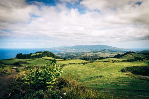
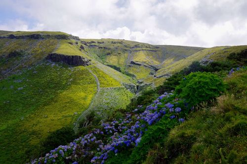
Mountain life
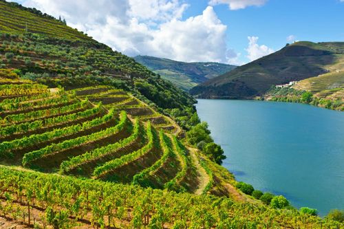
Over the last few decades life in the mountains has changed markedly. Farmers have moved from stone mountain houses to more modern dwellings on the valley floor while many of the former intensively cultivated Zêzere valley terraces have been abandoned in favour of spreading pine plantation. Meanwhile local village production is often now directed towards tourists – the local queijo da serra, an unctuous mountain cheese, and blankets from the wool of the grazing upland sheep, as well as rye bread, fruit preserves and honey from the fertile valleys are all widely available.
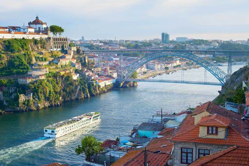
Guarda
GUARDA, 70km east of Viseu, is Portugal’s highest city, at an altitude of over 1000m. With a somewhat dour old town made of solid granite, its name is apt, as the original fortifications helped to guard the residents – and the mountain hinterland – from Spanish invaders. There’s not much left of the fortifications, but the historical core retains an air of dignified grandeur, especially in the streets around the cathedral. Locals will tell you their city is forte, farta, fiel e formosa (strong, wealthy, loyal and beautiful), though come on an overcast winter’s day and you may prefer to use fria e feia (cold and ugly). Either way, it makes a laidback base from which to explore the surrounding area.
The Beira Alta planalto
Beyond Guarda and the mountains lies the Beira Alta tableland, or planalto, with its ancient, scattered villages separated by mile after mile of boulder-strewn scrub. It’s a land of harsh winters, where even potatoes were hard to grow – in bygone days, roast or dried chestnuts were used as a substitute, plucked from the large trees that signal the entrance to many of the villages. Still, there’s a history here that’s central to Portugal’s identity, starting with the border castles that typify the eastern planalto, in particular the stunning star-shaped fortress of Almeida. Other castles and fortified settlements of particular interest are those at Castelo Rodrigo, to the north of Almeida, Castelo Bom and Castelo Mendo to the south, and Penedono and Marialva to the northwest. There’s a bygone wealth in the region, too, that sprang from the merchant trade of medieval Jewish settlements like Trancoso, which is easily the most attractive small town in the planalto. With a car, you could see the whole region in a couple of days, with the best overnight stops at Trancoso, Almeida or Marialva, with its upmarket holiday village.
Trancoso
TRANCOSO is still largely contained within an attractive circuit of medieval walls. It’s an uncommonly atmospheric little town, full of cobbled alleyways, well-kept gardens, shady squares and restored churches, all of which represent a tangible civic pride. It was here that Dom Dinis married the 12-year-old Isabel of Aragon in 1282, and later gave her the entire town as a gift; the wedding was solemnized in the small Capela de São Bartolomeu, not far from the town’s surviving main gate, the Portas d’el Rei, which is surmounted by the Trancoso coat of arms.
Like most planalto settlements, Trancoso grew up around its castelo – and like any town with a castle, trouble was generally to be expected from one quarter or another. Even once the Moors had been finally vanquished, there were still centuries during which armies came and went across the tablelands, using Trancoso as a base or a defensive position. It’s surprising that the walls have survived at all – never mind that they remain in such good condition – while its well-restored towers can be seen from afar as you drive towards town.
Medieval Trancoso had a large Jewish community, which enjoyed a relatively harmonious existence here (as in the rest of Portugal) until the late fifteenth century when Dom Manuel I ordered Jews to be expelled from the country. The former rabbi’s house in Trancoso is known as the Casa do Gato Preto (House of the Black Cat), its facade featuring a prominent Lion of Judah. Other buildings in the old town also display features that hark back to a prosperous Jewish community quietly going about its business until religion and politics stepped in. The oldest houses, for example, have separate doorways, one for business and one used by the family, while others are marked with carved crosses, ordered by the Inquisition (active in Portugal from the 1530s onwards) to show that the inhabitants were “New Christian” converts.
Bandarra, the cobbler-prophet
The statue in Trancoso’s Praça do Municipio might at first seem puzzling – a gentleman with a cobbler’s last and shoe, and a rolled parchment in hand. It is the supposed likeness of the town’s most famous son, Gonçalo Bandarra, a humble sixteenth-century shoemaker given to versifying – and, more to the point, coming up with prophecies that predicted the end of the world and the return of a hero-like king to save Portugal. The Inquisition took a dim view of this sort of thing and Bandarra was punished, and his verses banned, but the prophecies took on a life of their own with the later destruction of the cream of Portuguese nobility at the battle of Alcáçer-Quibir in Morocco (1578). The young crusader-king Dom Sebastião – killed in battle – was held by many to be the hero-king who would one day return to free Portugal from the Spanish yoke, and Bandarra was posthumously elevated to the status of a Nostradamus figure. He was eventually honoured with a tomb in the town’s Igreja de São Pedro.
Almeida
The most impressive of all Portugal’s fortified border settlements is surely ALMEIDA, within a mere cannon-shot of Spain. It’s a handsomely preserved eighteenth-century stronghold, laid out in the shape of a twelve-pointed star and well worth the effort of a visit – particularly during the twice-monthly feiras (on the eighth day and last Saturday), and the annual bash on September 1. The village within is charming, while a 3km walk around the walls – now overgrown with grass, and grazed by horses – shows you the true extent of the fortifications, though you can only really appreciate their shape by looking at the aerial-shot postcards sold in the gift shops.
Almeida played a key role in the Peninsular War. Besieged here in 1810 by the Napoleonic army, the garrison held out for seventeen days until, on July 26, a barrel of gunpowder ignited and began a devastating fire. That should have been it for the town, and the remaining survivors gave themselves up, but they were reprieved when the Duke of Wellington later arrived with full army in tow – the French army disappeared into the night and Almeida was saved.
The town defences
Almeida’s walls enclose a warren of cobbled lanes and whitewashed houses, punctuated by airy squares – inside the walled town, you’ll also find the village post office, a bank with ATM, a grocery shop and a few cafés. The main entrance is still through the original two consecutive defensive tunnel-gates of the Portas de São Francisco, complete with a wide, dry moat between inner and outer walls. Immediately inside the gates, to the left, are the long infantry barracks, while a right turn, past the gardens and along the walls, leads to the Casamatas (opposite the fire station), an underground storage area with a capacity for five thousand men and their supplies.
You’ll easily find your way up to what’s left of the castle, blown up in 1810, the foundations now exposed under a modern walkway. Behind here, in one of the star-points, is the picadeiro, the restored cavalry barracks and horse-training area, whose stables offer short riding lessons and horse-and-buggy rides around town.
Castelo Bom and Castelo Mendo
Twenty kilometres south of Almeida, tiny Castelo Bom preserves walled fortifications above an ancient village just 7km west of the Spanish border at Vilar Formoso. The Duke of Wellington’s forces secured the whole area during 1812 and 1813 while advancing into Spain, with Wellington himself headquartered at a house in a nearby village – hence the brown tourist sign with the incongruous English place-name “Wellington”.
Four kilometres west of Castelo Bom, the preserved medieval village of Castelo Mendo is a gem. Two headless Celtic granite pigs guard the main gateway, through which cobbled streets twist up to a grassy knoll topped by a roofless church and the sketchy remains of the castle keep. It’s a glorious spot, sitting on the lip of a sheltered bowl of land, with views across the undulating countryside.
Beira Baixa
The area east of Covilhã and the A23 motorway forms the upper boundary of the Beira Baixa, a landscape of undulating, heather-clad hills that extends to the Spanish border. The sun-bleached fields, grazing livestock and extensive olive groves provide a distinct contrast to the serra scenery, with visits concentrating on a series of fortified towns and fascinating villages. With a car you can see the whole region in a couple of days, and the best overnight stops are either at the underrated town of Belmonte or in one of the atmospheric houses of medieval Sortelha. On the other hand, travel by public transport is particularly difficult and slow. Only Belmonte and Sabugal can be reached easily by bus, though if you’re determined you’ll also get to Sortelha, while the provincial capital of Castelo Branco (on the Lisbon–Covilhã train route) has services to Monsanto and Idanha-a-Nova. But isolated destinations, such as Idanha-a-Velha and the Serra da Malcata nature reserve, are impossible to see by public transport.
Belmonte
The delightful small town of BELMONTE springs one of the best surprises in the Beiras, a charming place of sun-dappled squares, stone houses dripping with flower-filled windowboxes and lazy dogs basking on the cobbles. There are curiosities at every turn, such as the unusual pillory in the shape of an olive press, or the fire-blackened tree stumps outside the castle, which are the site of Christmas Eve carols and gambols. Meanwhile, in the Zêzere river valley, which Belmonte overlooks, vast peach and cherry orchards splash a blaze of colour each spring.
For the Portuguese Belmonte is best known as the birthplace of Pedro Álvares Cabral (1467–1520), the “discoverer” of Brazil, who was born in the tidily restored castelo overlooking town. Cabral’s father received the castle from Dom Afonso V, and adapted it as the family residence, though it later fell into disrepair. The Igreja de Santiago, just outside the castle walls, contains the Cabral family pantheon (though not the tomb of Pedro Álvares, which is in Santarém), while one of two tiny stone chapels on a hillock opposite is inscribed with the Cabral family coat of arms – two goats within a shield. The Cabral trail also extends to the main through-road named in his honour, where there’s a statue of the explorer clutching a large cross.
Sortelha
Twenty kilometres east of Belmonte, SORTELHA rises dramatically amid an unearthly, undulating highland plateau strewn with giant glacial boulders. It’s an ancient place that, for most of its existence, has gone about its business quietly, though the wonderful rock-built fortress suggests some frontier excitement in times past. Today it presents itself as a museum piece – with some beautifully restored lodgings available – since the number of permanent residents in the old town barely struggles into double figures. From the modern quarters on the Sabugal road it’s a five-minute walk uphill (follow “Castelo” signposts) to the fascinating walled old town – or you can drive up and park outside the main gate. A tight web of cobbled lanes wends between squat stone houses with red-tiled roofs, while rough carved steps in the castle keep offer a grandstand view over the valley below and the rock-speckled hillsides beyond.
Reserva Natural da Serra da Malcata
Between Sabugal and Penamacor, and reaching east from two local reservoirs to the Spanish border, spreads the Reserva Natural da Serra da Malcata. It’s one of the least-visited Portuguese nature reserves – access isn’t easy, and you really need to bike or hike to get much out of it – but it rewards the effort. If you’re very lucky, you might get a glimpse of a wild boar among the trees, or catch sight of the magnificent golden eagle or black vulture. What you won’t see – despite the emblem on all the promotional material – is the Iberian lynx, which is under serious threat of extinction. The last lynx was caught in the park in 1992, and there’s been no sign of one now for many years – fewer than two hundred are believed to exist in the wild, all now in Spain.
The reserve covers 16,000 hectares of heather-clad hills and oak woodland, with the reserve headquarters in Penamacor. They can usually rustle up an English-speaking member of staff, and the office also sells a map and separate walking booklet in English. Note that not all the hiking trails are currently signposted, as neglect, forest fires and vandalism have taken their toll – but you can always follow our directions instead.
A hike in the Malcata reserve
An easy hike, the Espírito Santo trail (4.6km; 1hr 30min), through typical Malcata heather and oak-wood scenery, starts near the village of Quadrazais. We hesitate to say you can’t get lost, but it would be difficult.
Drive 15km down the minor but good 538 road from Sabugal. At Quadrazais, take the Vale de Espinho road and 500m down this road take the right turn down a good dirt track (signposted “Reserva Natural, Rio Côa”) for 300m to the River Côa. Drive over the bridge to the parking and picnic area and then walk up to the trail information board. Don’t turn left for the chapel, but head straight up the track by the side of the wire fence, and turn right when you reach a T-junction after 750m. The track skirts the flank of a hill, through pine nurseries, and after 1.25km meets another T-junction at a ruined building, where you turn left (a wooden “PR1” marker shows the turn). Continue for another 1km, through shady groves of oak, reaching a left turn on a rise with wind turbine views (again, there’s a wooden “PR1” marker). Turn left here and it’s then 1.6km around the other flank of the hill, dropping down to the chapel and river, where you started.
It’s nice to combine this walk with lunch at the appealing Trutal Côa restaurant (open for lunch and dinner daily except Weds; 271 606 227), located at the trout farm, just a few kilometres away – it’s 2km before the village of Vale de Espinho.
Idanha-a-Velha
The isolated village of IDANHA-A-VELHA is 15km south of Monsanto by road, though closer by footpath. It might seem a forgotten backwater now, but it was a large Roman city in the first century BC and was later an important Visigothic settlement – one legend proudly records that the famous Visigothic king Wamba (reigned 672–680 AD) was born here, though at least two places in Spain claim him as well. Local folklore also has it that the inhabitants were driven from the village by a plague of rats during the fifteenth century, after which time the village fell into terminal decline. People do still live in Idanha-a-Velha today – grazing sheep on the plains and tending allotments down by the river – but it often seems almost deserted. Indeed, the village looks much as it must have done when the rats moved in, and perhaps not very different from when the Romans left, either.
Set amid burned plains and olive groves, the old village is still partly girded by a massive Roman wall. Down by the languid river the Roman bridge is still in use, while roses and vines are trained up the weathered walls of the houses, many built from plundered Roman stone. A stork’s nest tops the ancient basilica – signposted as the Sé – while outside here stand the ruins of the bishop’s palace and an even earlier Roman house. Perhaps the most fascinating restoration is of the old oil press or Lagar de Varas, with an ingenious pressing system utilizing two huge tree trunks, with roots intact. The basilica and the olive-oil-press building should be open during turismo office hours, but if not, just ask.
Castelo Branco and around
As capital of the Beira Baixa, CASTELO BRANCO has an air of prosperity compared to many of the nearby villages. Various frontier wars have robbed the town of much of its age-old history, save the sixteenth-century former town hall, a few handsome mansions, and some castle ruins at the top of town, where a garden miradouro offers sweeping views. Otherwise, it’s a pleasant enough, predominantly modern place of sweeping boulevards, squares and parks, with a broad, leafy central avenue that’s been opened up for pedestrians – there’s also a daily market at the Mercado Municipal, down Avenida 1° de Maio, near the turismo. That said, you don’t have to head very far out of town for some peace, quiet and natural beauty, with a string of stunning viewpoints and ancient villages within easy reach.
Parks, paths and projects in Beira Baixa
The lower (baixa) Beira region is a surprisingly good place for hiking and outdoor activities; better, in many ways, than the higher Serra da Estrela. It’s the result of a diverse set of interconnecting development projects, the main result of which is a growing series of reliable, waymarked footpaths and readily available information. Castelo Branco sits at the centre of the so-called Naturtejo Geopark, part of a wider pan-European project, while a large section of Tejo River hinterland is contained within the Parque Natural do Tejo Internacional (icnf.pt) – “internacional” because it’s mirrored on the Spanish side of the river too. There are good local walk circuits in many towns and villages, particularly between Monsanto, the Spanish border and Idanha-a-Nova, and also around the so-called Aldeias do Xisto (schist villages), west of Castelo Branco; you can pick up route leaflets and information in any local turismo. There’s even a long-distance hiking trail, the GR12-E7 (total 80km), that connects Termas de Monfortinho on the Spanish border with Idanha-a-Nova (some of the shorter walks connect with this; details on the local council website cm-idanhanova.pt).