Some history
The early history of the far south remains a hot topic of debate among archeologists. Although the ruins of an ancient city buried near Champasak (and not far from Wat Phou) indicate that the area was the centre of a thriving civilization as early as the fifth century, no one seems sure if the town was part of Champa, a Hinduized kingdom that ruled parts of central Vietnam for more than fourteen centuries, or the Chenla kingdom, which is thought to have been located near the Mekong River in present-day northern Cambodia, extending through what is now southern Laos. The Khmer were the first people to leave a clear imprint on the area, and the temple ruins that survive throughout the far south along the Mekong River suggest the region was an important part of the Khmer empire from the eighth to the twelfth century, when the Angkor empire was at its height. It is also thought that the better part of southern Laos was dominated by ethnic Khmer, in particular the Mon-Khmer ethnic groups that still inhabit the Bolaven Plateau region and the Annamite Mountains.
The ethnic Lao are relative newcomers to the region, having made their way slowly south along the Mekong as Angkor’s power, and its hold over present-day southern Laos, waned. By the early sixteenth century, King Phothisalat was spending much of his time in Vientiane and eventually, in 1563, the capital of Lane Xang was shifted from Luang Prabang to Vientiane. While the origins of the first ethnic Lao principality in the Champasak region are unclear, legends trace the roots of the Lao kingdom of Champasak back to Nang Pao, a queen said to have ruled during the mid-seventeenth century. The story goes that Nang Pao was seduced by a prince from a nearby kingdom and gave birth out of wedlock, initiating a sex scandal for which she has been remembered ever since. The queen supposedly acknowledged her mistake by decreeing that every unwed mother must pay for her sin by sacrificing a buffalo to appease the spirits, a tradition continued into the late 1980s by unwed mothers, known as “Nang Pao’s daughters”, from some of the ethnic groups in the area. Legend has it that Nang Pao’s actual daughter, Nang Peng, ceded rule over the kingdom to a holy man, who in turn sought out Soi Sisamouth, a descendant of Souligna Vongsa, the last great king of Lane Xang, and made him king in 1713.
Soi Sisamouth ascended the throne of an independent southern kingdom centred on present-day Champasak, near Wat Phou, and extended its influence to include part of present-day Thailand, as well as Salavan and Attapeu. But the king and his successor only managed to maintain a tenuous independence and, after its capital was captured by Siamese forces in 1778, Champasak was reduced to being a vassal of Siam, and so it remained until the French arrived more than one hundred years later, claiming all territory east of the Mekong River.
Caught between French ambition and a still-powerful Siam, Champasak was split in half – a situation which lasted until 1904, when a Franco–Siamese treaty reunited its territories. Following this, Champasak’s king, Kam Souk, had to travel to Pakse to swear his allegiance to France.
In 1946, Kam Souk’s son, Prince Boun Oum na Champasak, renounced his claim to the throne of a sovereign Champasak (in exchange for the title of Inspector General for life) and recognized the king of Luang Prabang as the royal head of a unified Laos, effectively ending the Champasak royal line. When he fled Laos after the communist takeover in the mid-70s, the Prince said the kingdom was doomed from the start because of Nang Pao’s misdemeanour: “With an unmarried mother as queen, everything started so badly that the game was lost before it began.”
Around Pakse
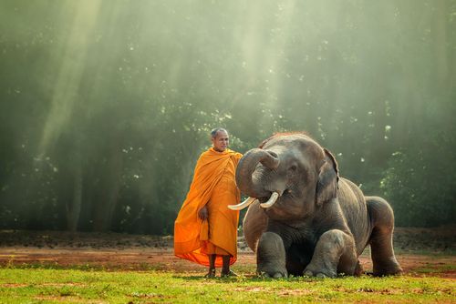
As more and more tourists make their way south to Pakse, the number of day-trip options has begun to grow. Ban Saphai, a silk-weaving village north of the city, offers the chance to see villagers weaving sin according to age-old practices, and experience life in a traditional town on the island of Don Kho in the middle of the Mekong. In the hills south of the city, the villagers of Kiatngong raise elephants, which can be hired for trekking, while nearby Ban Phapho presents the opportunity to observe elephants being trained for work in the forest. For 6-day Laos trips that include Pakse, these nearby villages work best as short cultural detours, adding Mekong island life, weaving traditions and rural scenery without requiring another overnight base.
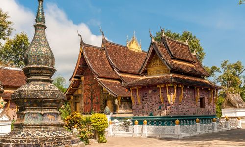
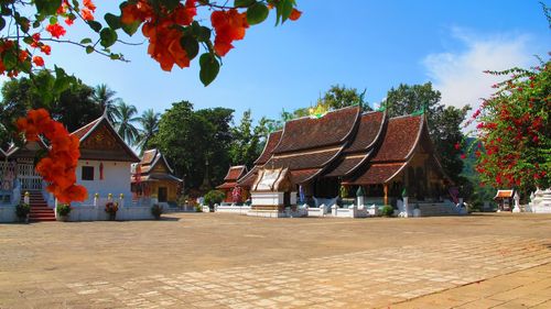
From Pakse, daily sawngthaews head south to the charming riverside town of Champasak, past misty green mountains and riverbanks loaded with palm trees. An up-and-coming backpacker town, Champasak serves as a gateway to Wat Phou and other Khmer ruins. Although it is easily possible to visit Wat Phou as a day-trip from Pakse, there is plenty of cheap accommodation available in Champasak, and basing yourself here allows you to take in the sights at a leisurely pace. With its old wooden houses, three temples, Khmer ruins, mountains and river-boat trips, plus guesthouses and good food, it’s easy to imagine Champasak becoming another Muang Ngoi in no time.
Other sights, such as the coffee plantations and waterfalls of Bolaven Plateau, can also be taken in on day-trips from Pakse.
Champasak Practicalities
Buses and sawngthaews (20,000K from Pakse) should let you off at Champasak’s tiny roundabout, where you’ll find almost everything you need, including a post office (open until 9pm weekdays for phone calls), and a tiny bank, which can exchange cash and travellers’ cheques. The wooden tourist office t 020/2206215 has a few useful maps and handouts. The ferry dock is about 2km north of here; tuk-tuks wait at the boat landing. Sawngthaews may drop you at the Anouxa Hotel, 1km north of the roundabout, claiming you’re in the centre of town. It’s a peaceful enough location, but the bungalows here are overpriced.
There are two proper hotels in town: Siamphone (120,500–200,000K), a huge apricot-coloured eyesore near the roundabout featuring basic, air-conditioned rooms with hot water and TV; and the boutique-style Inthira ($41–60), which has luxurious Lao-style rooms and suites. The most popular guesthouse is Vongpasit (40,500–80,000K), 2km south of the roundabout, which has en-suite bungalows and a restaurant with a nice deck overlooking the Mekong. Just south of the roundabout, Kham Phou (40,000K and under) has roomy doubles and triples and wooden en-suite bungalows in the garden. Fifty metres south, the Souchittra Guesthouse (40,000K and under) has above-average rooms in another old wooden house with a shared bathroom, plus self-contained bungalows on the lawn overlooking the Mekong. Dok Champa Guesthouse, on the roundabout, offers the best selection of Lao dishes in town and also rents bicycles, as do most of the guesthouses.
Moving on, three Pakse-bound buses pass by Champasak each morning on Route 13; (2hr; 20,000K); to catch one you’ll need to board a ferry to Ban Muang (7000K) and then take a tuk-tuk to the main road. For bus connections to Si Phan Don, cross the river to Ban Muang (ferries leave when full), get a lift up to Route 13 and wait for a bus heading south.
Wat Phou
One of the most evocative Khmer ruins outside Cambodia’s borders, Wat Phou, 8km southwest of Champasak, should be at the top of your southern Laos must-see list. It’s not hard to see why the lush river valley here, dominated by an imposing 1500m-tall mountain, has been considered prime real estate for nearly two thousand years by a variety of peoples, in particular the Khmer. The surrounding forests are rich with wildlife, including the rare Asiatic black bear. The pristine state of the environment – it is without question one of the most scenic landscapes chosen by the Khmer for any of their temples – was a major factor in UNESCO’s decision to name the area a World Heritage site.
Wat Phou (“Mountain Monastery” in Lao) is actually a series of ruined temples and shrines dating from the sixth to the twelfth centuries. Although the site is now associated with Theravada Buddhism, sandstone reliefs indicate that the ruins were once a Hindu place of worship. When viewed from the Mekong, it’s clear why the site was chosen. A phallic stone outcropping, easily seen among the range’s line of forested peaks, would have made the site especially auspicious to worshippers of Shiva, a Hindu god that is often symbolized by a phallus.
Archeologists tend to disagree on who the original founders of the site were and when it was first consecrated. The oldest parts of the ruins are thought to date back to the sixth century and were most likely built by the ancient Khmer, although some experts claim to see a connection to Champa. Whatever the case, the site is still considered highly sacred to the ethnic Lao who inhabit the region today, and is the focus of a festival in February, attracting thousands of Lao and Thai pilgrims annually.
THE SITE
At the entrance to the site, a small museum houses pieces of sculpture found among the ruins as well as some said to have belonged to Prince Boun Oum. The stone causeway leading up to the first set of ruins was once lined with low stone pillars, the tips of which were formed into a stylized lotus bud. On either side of the causeway there would have been reservoirs known in Khmer as baray. As ancient Khmer architecture is rich in symbols, it is surmised that these pools represented the oceans that surrounded the mythical Mount Meru, home of the gods of the Hindu pantheon.
Just beyond the causeway, on either side of the path, two megalithic structures of sandstone and laterite mirror each other. According to local lore, they are segregated palaces, one for men and the other for women. Archeologists are sceptical though, pointing out that stone was reserved for constructing places of worship, and, even if this hadn’t been the case, the vast interiors of both buildings were roofless and would have afforded little shelter. The structure on the right as you approach is the best preserved. Its carved relief of Shiva and his consort Uma riding the sacred bull Nandi is the best to be found on either building.
As the path begins to climb, you come upon jagged stairways of sandstone blocks. Plumeria (frangipani) trees line the way, giving welcome shade and littering the worn stones with delicate blooms known in Lao as dok champa, the national flower of Laos. At the foot of the second stairway is a shrine to the legendary founder of Wat Phou. The statue is much venerated and, during the annual pilgrimage, is bedecked with offerings of flowers, incense and candles. When and why this one statue has come to be venerated in such a fashion is unknown, and once again, local folklore and archeological record diverge.
Continuing up the stairs, you come upon the final set of ruins, surrounded by mammoth mango trees. This uppermost temple contains the finest examples of decorative stone lintels in Laos. Although much has been damaged or is missing, sketches done by Georges Traipont, a French surveyor who visited the temple complex in the waning years of the nineteenth century, show the temple to have changed little since then. On the exterior walls flanking the east entrance are the images of dvarapalas and devatas, or female divinities, in high relief. On the altar, inside the sanctuary, stand four Buddha images, looking like a congress of benevolent space aliens. Doorways on each side of them lead to an empty room with walls of brick; it is thought that these walls constitute the oldest structure on the site, dating back to the sixth century.
To the right of the temple is a Lao Buddha of comparatively modern vintage, and just behind the temple is a relief carved into a half-buried slab of stone, depicting the Hindu trinity – a multi-armed, multi-headed Shiva (standing) is flanked by Brahma (left) and Vishnu (right). Continuing up the hill behind the temple, you’ll come to a shallow cave, the floor of which is muddy from the constant drip of water that collects on its ceiling. This water is considered highly sacred, as it has trickled down from the peak of Lingaparvata. In former times, a system of stone pipes directed the run-off to the temple, where it bathed the enshrined Shivalinga. By tradition, this water was utilized in ceremonies for the coronation of Khmer kings and later the kings of Siam. Even today, Lao pilgrims will dip their fingers into a cistern located in the cave and ritually anoint themselves, although this is something foreign visitors should respectfully avoid.
If you follow the base of the cliff in a northerly direction, a bit of sleuthing will lead you to the enigmatic crocodile stone, which may have been used as an altar for pre-Angkor-period human sacrifices, though there is no hard evidence that ritual sacrifice was a part of the ceremonies that took place here. Nearby is a pile of sandstone rubble that once formed a pavilion and is thought by archeologists to be one of the oldest structures on the site. A few metres away to the north is the elephant stone, a huge, moss-covered boulder carved with the face of an elephant. This carving is relatively recent, probably dating from the nineteenth century.
The legacy of the Angkorian empire
In the mid-nineteenth century, French explorers began stumbling across the monumental ruins of a centuries-dead empire that had once blanketed mainland Southeast Asia. When word of these jungle-clad “lost cities” reached Europe, the intrigued populace assumed they must have been the work of expatriate Romans or perhaps some far-wandering tribe of Israelites. But as French exploration and colonization of Indochina expanded, scholars began to acknowledge they were the work of a highly sophisticated Southeast Asian culture.
The Khmer, whose descendants inhabit Cambodia today, controlled a vast empire that stretched north to Vientiane in Laos and as far west as the present-day border of Thailand and Burma. From its capital, located at Angkor in what is now northwestern Cambodia, a long line of kings reigned with absolute authority, each striving to build a monument to his own greatness which would outdo all previous monarchs. With cultural trappings inherited from earlier Khmer kingdoms, which in turn had borrowed heavily from Indian merchants that once dominated trade throughout Southeast Asia, the Khmer rulers at Angkor venerated deities from the Hindu and Buddhist pantheons. Eventually, a new and uniquely Khmer cult was born, the devaraja or god-king, which propagated the belief that a Khmer king was actually an incarnation of a certain Hindu deity on earth. Most of the Khmer kings of Angkor identified with the god Shiva, although Suryavarman II, builder of Angkor Wat, the most magnificent of all Khmer monuments, fancied himself an earthly incarnation of Vishnu.
In 1177, around 27 years after the death of Suryavarman II, armies from the rival kingdom of Champa took advantage of political instability and sacked Angkor, leaving the empire in disarray. After some years of chaos, Jayavarman VII took control of the leaderless Khmer people, embracing Mahayana Buddhism and expanding his empire to include much of present-day Thailand, Vietnam and Laos. But the days of Khmer glory were numbered. Soon after the death of Jayavarman VII the empire began to decline and by 1432 was so weak that the Siamese, who had previously served as mercenaries for the Khmer in their campaigns against Champa, were also able to give Angkor a thorough sacking. The Siamese pillaged the great stone temples of the Angkorian god-kings and force-marched members of the royal Khmer court, including the king’s personal retinue of classical dancers, musicians, artisans and astrologers, back to Ayutthaya, then the capital of Siam. To this day, much of what Thais perceive as Thai culture, from the sinuous moves of classical dancers to the flowery language of the royal Thai court, was actually acquired from the Khmer. When the Angkorian empire collapsed, Siam moved in to fill the power vacuum and much of the Khmer culture absorbed by the Siamese was passed on to the Lao.
Decorative lintels at Wat Phou
The importance of the decorative lintel in Khmer art cannot be overstated. Here, more than anywhere else, Khmer artisans were free to display their superb stone-carving skills. Their imaginative depictions of deities, divinities, characters and events from Hindu and Buddhist mythology are recognized as some of the most exquisite art ever created. Early examples date from the seventh century, and as the styles and motifs have evolved over the centuries, experts are able to date lintels by comparing them to known works. The lintels at Wat Phou are listed below.
- The god Krishna defeats the naga Kaliya In this story from the Bhagavad Purana, Krishna defeats Kaliya, a menacing water serpent that has been terrorizing villagers.
- The god Vishnu riding the bird-man Garuda Although Vishnu on Garuda was a common theme in Khmer art, images of the two were rarely depicted on lintels.
- Indra riding Airavata Despite being a Hindu god, Indra holds a significant place in Theravada Buddhist mythology. Until the Lao revolution Airavata, the three-headed elephant, was the official symbol of the Lao monarchy.
- Indra on Airavata A larger and more detailed depiction of #3.
- Deity atop Kala Although this deity is very commonly depicted on lintels, it is uncertain just who it is supposed to be. As the deity is holding a mace and sitting in the “royal ease” pose, perhaps it depicts a generic king or ruler.
- Deity atop Kala (see #5) On the portico above the lintel is what is left of a scene from the Churning of the Sea of Milk myth, a contest between gods and demons for possession of the elixir of immortality. This scene is depicted most spectacularly on the bas-reliefs at Angkor Wat in Cambodia.
- Krishna killing Kamsa From the Bhagavad Purana, a gruesome depiction of Krishna tearing his uncle in half. According to this myth, it was foretold that King Kamsa’s death would come at the hands of one of his own family members. This prophecy launched the king on an orgy of killing which was only halted when his nephew put him to death.
- Deity atop Kala (see #5)
- Deity atop Kala (see #5) On the ruined portico above this lintel are the remains of a depiction of the god Vishnu in his incarnation as Narayana, reclining in cosmic slumber as he floats atop a naga on the waters of a vast primordial ocean.
- Shiva as a rishi atop Kala Shiva is depicted as a wandering ascetic, perched above Kala.
- Deity atop Kala (see #5) This lintel has been badly damaged, possibly by looters trying to remove part of the sculpture for the thriving stolen-antiquities trade in Thailand.
- Deity atop Kala (see #5)
The Bolaven Plateau
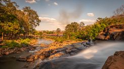
As gradual as Route 23’s eastwardly climb out of Pakse is, there’s no mistaking when you’ve reached the Bolaven Plateau, roughly 30km from Pakse. The suffocating heat of the Mekong Valley yields to a refreshingly cool breeze, and coffee and tea plantations, exulting in the rich soil, begin cropping up along either side of the highway. Hilly, roughly circular in shape, and with an average altitude of 600m, the high plateau has rivers running off in all directions and then plunging out of lush forests along the Bolaven’s edges in a series of spectacular waterfalls, some more than 100m high, before eventually finding their way to the Mekong. Four provincial capitals – Pakse, Salavan, Xekong and Attapeu – surround the Bolaven, while the main settlement on the plateau itself is the town of Paksong.
The French, recognizing the fertility of the terrain, cleared wide swathes of forests and planted strawberries, coffee, tea and cardamom. Although it was cardamom that provided the south’s chief export during colonial times, coffee is the crop that dominates the plateau these days, earning the well-paved highway that links Pakse with Paksong the moniker the Coffee Road.
Long before the French planted their first coffee crop, midland hill tribes were practising swidden agriculture on the plateau. Today, twelve ethnic groups, including lowland Lao, Laven, Alak, Suay and Taoy, live in the area. Given that ethnic minorities are in the majority here, it’s only fitting that the plateau takes its name from one of these groups, the Laven.
One of the easiest waterfalls to access here is Tad Lo on the forested northern edge of the plateau, a popular spot with travellers looking for somewhere pleasant to relax for a few days and enjoy the plateau’s cool climate. You can lounge in the pools of the Xe Set River below the waterfall and do some elephant trekking to nearby tribal villages. South of Route 23 between Pakse and Paksong is the Dong Hua Sao NBCA, containing the Tad Fan Waterfall. Paksong was levelled in bombing raids during the war and has not been able to rekindle the charm it once possessed.
Lak Sao-et, the tiny village 21km from Pakse along Route 23, is an important junction for bus transfers – there are connections here for Tad Lo and Salavan in the northeast, and for Paksong and beyond.
The Bolaven revolt
A chanting mob, two thousand-strong, descended on Savannakhet in April 1902, convinced by a holy man that any bullets fired at them would be miraculously transformed into frangipani flowers. Three times they attacked, and each time they were mown down by troops from France’s “Garde Indigène”. The rout, which left 150 dead, marked the climax of the so-called Holy Man’s Revolt, which had its origins with the arrival of the French in 1893 and simmered on for many years afterwards in the highlands of the south.
The French brought with them administrative changes, increased taxation and reshuffled the traditional relationships that had guided life in Laos for generations. At first, resistance was textbook Lao. Villagers avoided direct confrontation, preferring to make their displeasure about the new order known through passive means: villages undercounted their populations, adapted a generally uncooperative attitude, or simply left. The first serious opposition didn’t arise until eight years after the French employed gunboat diplomacy to wrest control of Lao territory from Siam.
When Ong Kaew, an Alak tribesman believed to possess supernatural powers, prophesied that “the end of the world as we know it” was nigh, he found willing listeners among midland tribes living along the plateau, chafing under increased taxes and corvée labour demands instituted by the French commissioner of Salavan. Sensing that Ong Kaew was gaining too much influence, the commissioner ordered the burning of a pagoda erected in the holy man’s honour. This only served to increase support for Ong Kaew, and in April 1901, he and a band of rebels attacked the commissioner and his guard. Soon after, nearly all of the Bolaven region was in revolt.
By 1902, the revolt had spilled across the Mekong and briefly gained the support of older lowland Lao families, who felt threatened by the collapse of the social and economic order to which they were accustomed. After the disastrous march on Savannakhet, Ong Kaew and another Lao Theung leader, Ong Kommadam, whose son would later continue to resist the French and ultimately become a Pathet Lao leader, retreated across the Xe Kong as villages were burned and less fortunate leaders rounded up and executed. But the defeat at Savannakhet and renewed attempts by France to pacify the Bolaven region did little to dispel the holy man’s popularity, and it took a new commissioner at Salavan, Jean Dauplay, to force Ong Kaew to surrender in 1907. Three years later, with the holy man’s influence over the Bolaven inhabitants as strong as ever, Dauplay arrested Ong Kaew, who died “during a jail break” the next day. The revolt was effectively over.
Not all was lost during the insurrection. French authorities were careful to place more of the burden on lowland Lao when they raised taxes in 1914, and Ong Kaew had unwittingly sown the seeds for what the Pathet Lao would later claim to be the stirrings of Lao nationalism.
Laos' Remote Provinces
Salavan, Xekong and Attapeu, cut off from the Mekong River Valley by the Bolaven Plateau and made remote by the rugged jigsaw of the Annamite Mountains, are some of the least-visited provinces in Laos. Until recently, poor infrastructure and the scars of war conspired to keep the region isolated. With the Ho Chi Minh Trail streaming across their borders, these provinces were victims of some of the heaviest bombing during the Second Indochina War. Villages were decimated, roads destroyed and in some places the dangerous litter of battle still lies about. Yet these factors kept the densely forested mountains of Attapeu and Xekong pristine until the beginning of this century. Today, intense logging along the Vietnamese border is turning parts of this once rich ecosystem into a moonscape. For the time being, however, the provinces are still home to a variety of wildlife and numerous ethnic minority villages.
Arcing around the Bolaven Plateau, these provinces can be seen in a convenient clockwise loop from Pakse. From Lak Sao-et, 21km east of Pakse, head northeast for roughly 100km along well-maintained Route 20 towards Salavan, where bus connections are available for the bumpy 90km trip to Xekong via Thateng, the dusty northern gateway to the Bolaven Plateau. Just east of the plateau, uninspiring Xekong provides a jumping-off point for the pretty five-hour boat trip along the babbling Xe Kong to Attapeu, capital of Laos’s southeasternmost province.
From Attapeu, it can be a rough haul back to Pakse up the eastern flank of the Bolaven and through the coffee plantations surrounding Paksong. Unfortunately, public buses have yet to start travelling impassable Route 18, the shortcut to Si Phan Don, which shadows the southern edge of the Plateau.
The Xe Kong River Valley
The Xe Kong is one of Laos’s great rivers, starting high in the Annamite Mountains from the eastern flanks of the 2500-metre-high Mount Atouat and flowing southwestward around the southern edge of the Bolaven Plateau. It enters Cambodia via the Xe Pian NBCA, eventually joining the Mekong River in that country, north of Stung Treng.
The main towns along the Xe Kong in Laos are Xekong and Attapeu, which are linked by a paved but bumpy road. If you’re heading this way from Salavan, the first part of the journey involves a laborious climb through rich jungle and midland tribal villages up the steep curves of the Bolaven Plateau to Thateng, 40km away.
A dusty junction of threadbare markets and crooked wooden houses with thatch roofs, Thateng was where the French commissioner to Salavan, Jean Dauplay, “the father of Lao coffee”, chose to settle in the 1920s. Sadly, Thateng’s strategic location as the gateway to the plateau, a grip on which was considered key to controlling the bulk of the far south, made it a prime target for American bombs. The town was basically wiped out, and although villagers returned after the war, the place is nowadays little more than an unappealing transit point.
Xekong to Attapeu by river
If you’ve made it as far as Xekong, the scenic Xe Kong, which meanders through little-visited countryside, provides a strong incentive to charter a motorized pirogue for the journey south to Attapeu – not cheap at $60–70, but well worth the expense. To find a boat in Xekong, follow the road that passes in front of the Sekong Souksamlane hotel south for 1km until you reach a boat landing on the riverbank, where you’ll have to negotiate a price with the boatmen. Even if it’s more expensive, go for one that can offer you a life jacket.
The pirogues make the journey to Attapeu through gentle rapids and past lushly forested riverbanks, where people living in the surrounding hills come to catch fish and bathe. The journey usually takes around five hours, but late in the dry season it can take seven, and at this time the shallow waters require passengers to walk short stretches of the journey along the bank. Although the fare doesn’t rise at this time of year, captains limit the number of passengers to two, thereby increasing the price per person. Keep in mind that this river can be hazardous during high waters, and if you’re not a strong swimmer you should probably give it a pass; more than one tourist has drowned on this journey.
During the Second Indochina War, US aircraft struck at the threads of the Ho Chi Minh Trail running parallel to the river, hoping to disrupt the endless tide of men and supplies streaming southwards. Bombs invariably wound up in the river and the resulting explosions sent scores of fish floating belly-up to the surface, unintentional war reparations quickly collected by villagers living amid a battlefield. Today’s depleted fish catches are still blamed on the war, but more modern fishing equipment has surely had an impact, as has the use of explosives for catching fish, a technique that was utilized by Vietnamese soldiers during the war and remains part of the Cambodian fisherman’s arsenal along some stretches of the river. One victim of such high-impact methods, the Irrawaddy dolphin, until the 1980s a frequent visitor to Attapeu’s maze of rivers in the rainy season, now rarely visits these waters.