Kisumu
In the sultry atmosphere of Kisumu, a distinctive smell from the lake – fish, mud and rotting vegetation – drifts in on a vague breeze from central Africa. More laidback than any other big town in Kenya, Kisumu was founded as a railway town and lake port, becoming the country’s third-largest town as its fortunes rose with the growth of trade in colonial East Africa and the newly independent nations. It suffered badly following the East African Community’s break-up, however, and throughout the 1980s and early 1990s the port was mostly dormant. Kisumu’s position might lead you to expect a bustling waterfront and a lake-facing atmosphere, although in fact the town has now turned its back on the water, focusing instead on the commercial centre and land links to the rest of Kenya. Although some commercial shipping has resumed, and the port sporadically buzzes with loading or unloading (and people looking for a lift to Uganda or Tanzania), low water levels and water hyacinth have held back progress.
Even if the time-warped atmosphere of a place that’s been treading water for three decades may not be much comfort to its inhabitants, Kisumu is one of the few upcountry towns with real character. It’s a tranquil, easy-going town, where even the manambas at the bus station are unusually calm. Any anticipation of claustrophobia is quickly soothed by the spacious, shady layout. If you’ve just come from Nakuru, the contrast is striking. It’s a good idea to find somewhere to stay soon after arriving, before starting any energetic wanderings, as it gets tremendously hot here.
Brief history of Kisumu
The train line from Mombasa reached the lake by 1901, reassuring the British public who were having serious doubts that the “Lunatic Line”, as it was dubbed, would ever reach completion, but the first train only chugged into the station at Port Florence, as Kisumu was originally known, in 1903 when the Mau Escarpment viaducts were completed. By then, European transport had already arrived at the lake in the form of a steamship brought up from Mombasa piece by portered piece, having steamed out from Scotland in 1895. Many of the ship’s parts were seized en route from the coast and recycled into Nandi ornamentation and weaponry, and it was five years before a complete vessel could be launched on its maiden voyage across the lake to Port Bell in Uganda.
By all accounts Kisumu was a pretty disagreeable place in the early years. Apart from the endemic sleeping sickness, bilharzia and malaria, the climate was sweltering and municipal hygiene primitive. But it quickly grew into an important administrative and military base and, with the consolidation of the colonies in the 1930s and 1940s, became a leading East African entrepôt and transport hub, attracting Asian investment on top of the businesses that had been set up at the railway terminus when the Indian labourers were laid off. Kisumu’s rise seemed unstoppable until 1977, when the sudden collapse of the East African Community, more or less overnight, robbed the town of its raison d’être. The partial reformation of the community in 1996 brightened prospects, and by 1999 the port was relatively busy, thanks largely to UN World Food Programme transit goods destined for war-torn Rwanda and Congo.
Since then, however, Kisumu has again seen a downturn in its fortunes, owing to the decline of the local sugar industry, sugar cane being the surrounding region’s main cash crop. Dumping of subsidized sugar by the EU led to a worldwide crash in prices, and this in turn forced the closure of sugar refineries at nearby Muhoroni and Miwani, which were the mainstays of the local economy. More recently, parts of Kisumu were badly hit during the post-election clashes in 2007–8, though recovery since then has been rapid.
Kisumu Museum
Foremost among the town’s sights is the engaging and ambitious Kisumu Museum. Set in a large garden with carefully labelled trees, the main gallery happily mingles zoological exhibits with ethnographic displays. Apart from the rows of trophy-style game heads around the walls, the stuffed animals and preserved insects and crustaceans are displayed with considerable flair and imagination. Particularly good use has been made of old exhibits from Nairobi’s National Museum. A free-swinging vulture, for example, spins like a model aircraft overhead while, centre stage, a lion is caught in full, savage pounce, leaping onto the back of a hysterical wildebeest in the most action-packed piece of taxidermy you’re ever likely to see.
The ethnographic exhibits are illuminating, too. The Maasai aren’t the only people who take blood from their cattle for food: Kalenjin peoples like the Nandi and the Kipsigis once did the same, and even the Luo lived mostly on cow’s blood mixed with milk before they arrived at Lake Victoria and began to cultivate and fish. In separate halls from the main gallery are a small, but worthwhile aquarium, illustrating the problem of fish depletion in the lake (see what your tilapia looked like before it became a curry), and a snake house with a fairly comprehensive collection of Kenyan species. Outside, the tortoise pen and croc pond seem rather pointless extras. The crocodiles, getting extremely large, are fed on Monday evenings at around 5.30pm.
The Luo
The Luo are the second-largest ethnic group and one of the most cohesive “tribes” in Kenya. Their distinctive language, Dholuo, closely resembles the Nuer and Dinka languages of southern Sudan, from where their ancestors migrated south at the end of the fifteenth century. They found the shore and hinterland of Lake Victoria only sparsely populated by hunter-gatherers, scattered with occasional clearings where Bantu-speaking farmers had settled over the previous few centuries. Otherwise, the region was wild: untouched grassland and tropical forest, dense with heavy concentrations of wildlife.
The Luo were swift invaders, driving their herds before them, from water point to water point, always on the move, restless and acquisitive. They raided other groups’ cattle incessantly and, within a few decades, had forced the Bantu-speakers away from the lakeshore. Despite the conflict, intermarriage (essentially the buying of wives) was common and the pastoral nomads were greatly influenced by their Bantu-speaking in-laws and neighbours, ancestors of the present-day Luhya and Gusii.
The Luo today are best known as fishermen, a lifestyle that had sustained them while migrating along the rivers, but they also cultivate widely and still keep livestock. Culturally, they have remained surprisingly independent, and are one of the few Kenyan peoples who don’t perform circumcision. Traditionally, children had six teeth knocked out from the lower jaw to mark their initiation into adulthood, but the operation is hardly ever carried out these days. Christianity has made spectacular inroads among the Luo, with an estimated ninety percent being believers, but it does not seem to have destroyed their traditional culture quite as thoroughly as it has elsewhere. Despite the ubiquity of Gospel singing, traditional music, especially the playing of the nyatiti lyre, is still very much alive and well worth listening out for.
Kitale
KITALE is smaller than Eldoret, and not much more exciting, but has more going for it from a traveller’s point of view, primarily as the base for visits to Mount Elgon, Kenya’s second giant volcanic cone, and the superb, very underrated hiking country in the area. It’s also an obvious springboard for the Cherangani Hills, and a straightforward departure point for trips to the west side of Lake Turkana. There’s a national park nearby – the little-known but easily accessible Saiwa Swamp, which can only be explored on foot. In addition, the town also has two museums and a couple of other sites to visit.
The town’s present population is a mix of tribes, including Nandi, Pokot, Marakwet, Sabaot and Sengwer, as well as a few Luhya, Kisii and Kikuyu and an influential Asian community. Like most towns in the Rift Valley and western Kenya, it was seriously affected by the post-election clashes of 2007–08, but managed to make a swift recovery.
Lake Victoria
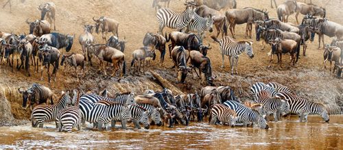
Lake Victoria fills a shallow depression (no deeper than 80m) between the Western and Eastern Rift valleys, yet it is not part of the Rift system. Until the 1960s, it was home to around five hundred different species of brilliantly coloured tropical fish, known as haplochromines or cichlids, all of them endemic – unique to the lake. Scientists, puzzling over how such a dazzling variety of species came to evolve in this largely uniform environment in the space of no more than a million years, have suggested that, at some stage in its history, the lake must have dried into a series of small lakes in which the fish evolved separately. Lake Victoria’s cichlids are popular aquarium fish, and one of the commonest larger species, the tilapia, is a regional speciality, grilled or fried and served whole.
In the early 1960s, a voracious carnivore, the Nile perch, was introduced to the lake, and proceeded to eat its way through the cichlid population, driving some species close to extinction, though many have held on in parts of the lake which were too shallow for perch, or in smaller lakes around the main one. For local people, the introduction of the perch, which can reach a weight of 250kg, has been a bit of a Trojan horse: while they’re consumed locally and sold for export (good news for the lakeshore economy), traditional fishing and processing have been hit hard by the arrival of modern vessels and factories joining in the feast and taking their profits elsewhere.
The lake has other problems, however. Algae have proliferated, due to industrial and sewage pollution, depriving the lake of oxygen. More than three million litres of human waste drain into the lake every day, and the Swedish development agency, SIDA, estimates that Kenya, with the smallest share of the lake’s shoreline, is its main polluter. As well as suffering a dramatic fall in oxygen levels, the lake is becoming so murky that the remaining cichlids are unable to identify mates, so that hybridization is occurring. Meanwhile, the building of the causeway between Mbita and Rusinga Island has turned the Winam Gulf into even more of a pond, with only one outlet, inhibiting currents and making its water even less healthy.
Another threat comes from the water hyacinth, originally native to Brazil. This floating weed grows quickly around the lakeshore and spreads like a carpet across the surface, blocking out the light, choking the lake to death and snaring up vessels. Since the mid-1990s, Homa Bay, Kendu Bay and Kisumu have all at times been strangled by kilometre-wide cordons of the weed, inhibiting passage to all but the smallest canoes, with disastrous results for the local economy. Solutions have included the promotion of products (furniture, paper, even building materials) made from harvested hyacinth. In 2001, mechanical clearance enabled passenger ferries to resume, only for falling water levels to cause their suspension once more. There’s been a resurgence of the invasive weed since 2006, and the nutrient run-off following occasional rains spreads the deadly canopy even further.
Lake Victoria health hazards
Although going out on the lake is fun, it is, unfortunately, a disease-ridden body of water, and even though there aren’t always clouds of mosquitoes, the malaria risk is quite high. Snails carrying bilharzia also flourish in the reeds around the fringes of the lake, and although the Luo wash and swim in it and sail their vividly painted, dhow-like mahogany canoes on it, the danger of bilharzia is all too real. It’s very rare to get the disease after brief contact with infected water, but you should avoid getting wet, as far as possible, if you’re fishing or boating, and don’t even think about swimming.
Mfangano Island
Said to have been inhabited for centuries, enigmatic Mfangano Island is out of range of the smallest fishing boats, and, aside from a handful of motorbikes, largely without vehicles. This may be about to change, though, since a twice-daily ferry service from Mbita and the newly completed ring road around the island have gone a long way toward opening up Mfangano to the outside world. The island is populated by a curious mixture of immigrants from all over Kenya, administered by a chief and three sub-chiefs with help from a trio of policemen. Monitor lizards swarm on the sandy shores and hippos are much in evidence out in the water.
Larger and more populous than Rusinga, with a similarly rugged landscape but better vegetation cover, Mfangano’s greatest economic resource is still the lake itself. As on Rusinga, the local fishing techniques are unusual: the islanders fish with floating kerosene lamps hauled shorewards, or towards a boat, to draw in the schools to be netted. Despite the new road, many local residents still rely on a network of temporary footpaths that are constantly changing course; you can use these paths to walk through the interior of Mfangano, though it’s always easier if you have a guide.
Rusinga Island
Small and austerely beautiful, Rusinga Island has high crags dominating its desolate, goat-grazed centre, and a single dirt road running around the circumference. Life here is difficult, with drought commonplace, and high winds a frequent torment. The occasional heavy rain either washes away the soil or sinks into the porous rock, emerging lower down where it creates swamps. Ecologically, the island is in very dire straits: almost all its trees have been cut down for cooking fuel or to be converted into lucrative charcoal. These conditions make harvests highly unpredictable and most people fish to make ends meet (although the causeway has forced them to make longer fishing trips), either selling the catch on to refrigerated lorries or bartering directly for produce with traders from Kisii. Yet the islanders, in common with their mainland cousins, remain an unfailingly friendly and cheerful bunch, more than happy to make contact with wayward travellers.
If you’re interested in making a contribution to the welfare and development of the Rusinga community, there’s a permaculture project and education centre at Badilisha Ecovillage near the lakeshore at Kaswanga, on the north side of the island, 9km from Mbita, that brings together green-minded volunteers from around the world to work with AIDS orphans, in local schools doing support work or working the land on the permaculture project, founded on the principles of sustainability and respect for the environment. You can stay here for a night or a couple of months (see Lake Victoria’s ecology and economy), and the stays make for an excellent way of getting to know local issues in a remote and challenging rural setting.
The island is rich in fossils, and was the site of Mary Leakey’s discovery of a skull of Proconsul africanus (a primitive anthropoid ape), which can be seen in the National Museum. It was also the family home of Tom Mboya, the civil rights champion, trade unionist and charismatic young Luo politician who was assassinated in Nairobi in 1969, a turning point for the worse in Kenya’s post-Independence history, sparking off a crisis that led to more than forty deaths in widespread rioting and demonstrations.
Mount Elgon National Park
Straddling the Kenya–Uganda border, Mount Elgon is hidden in clouds most of the time, its precise outline hard to discern. The name comes from the Maasai Ol Doinyo Ilgoon , meaning “Breast Mountain”, and, like Mount Kenya, it’s an extinct volcano, around whose jagged and much-eroded crater rim the flat-topped peaks crop up like stumpy fingers of an upturned hand. The two mountains are comparable in bulk, but Elgon is lower. It’s below the snowline and less precipitous, which is encouraging if the thought of tackling the “loneliest park in Kenya” was putting you off.
The highest of the peaks, Wagagai (4321m; there’s also nearby Little Wagagai, at 4298m), is across the caldera in Uganda, but the most evocatively shaped peaks (Sudek, 4176m; Lower Elgon, 4301m; Koitoboss, 4187m; and Endebess Bluff, 2563m) belong to Kenya. Part of the east side of the mountain is enclosed within the confines of Mount Elgon National Park. Outside this zone is a forest reserve, with some restrictions on movement owing to the presence of poachers and cattle rustlers. The park itself, however, is open for business.
The Elkony Caves
Perhaps Elgon’s most captivating attraction is the honeycomb of caves on the lower slopes. Some of these were long inhabited by one of the loosely related Kalenjin groups, the Elkony (whose name, in corrupted form, was given to the mountain), and used both as living quarters and as livestock pens at night. There is evidence that the caves had a ritual function as well – Chepnyalil Cave contains a structure that might have served as an altar or shrine, and its walls are painted with a red-and-white frieze of cattle. The caves are also linked with Luhya circumcision ceremonies, in which boys spent their month-long initiation period covered from head to toe in the white diatomite powder found in the area, before returning home as men. The Elkony were officially evicted from the caves by the colonial government, who insisted that they live in the open “where they could be counted for tax”, but several caves were still occupied by extended families within living memory.
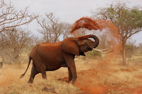
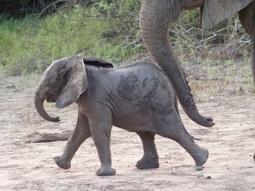
The largest and most spectacular cave is Makingeny Cave, close to the road and marked by a cascade falling over the entrance. It makes a good hike teamed up with its neighbour, Kitum Cave, a twenty-minute hike to the south. Early explorers believed that some of the caves were artificial, one report referring to “thousands of chisel and axe marks on the walls”. In fact, generations of elephants were responsible: the well-signposted Kitum Cave was the mineral fix of local elephants, and on rare occasions they still walk into the cave at night to gouge the salt-flavoured rock from the walls with their tusks. If you’re exceptionally lucky, a night vigil at Kitum Cave may be repaid by a visit from the elephants; but if not, the thousands of bats and the sounds of the forest are good compensation.
Mayhem on Mount Elgon
Despite the tranquillity inside the national park, communities around the southern slopes of Mount Elgon have been embroiled in land disputes with the government since colonial times, and wracked by violent episodes over the past two decades. The most recent began in 2005 with the formation of the Sabaot Land Defence Force. Formed to resist a forced resettlement programme, the SLDF rapidly degenerated into a brutal insurgency that terrorized unsupportive Sabaot villagers and Okiek tribespeople alike, with murder, mutilations and rape, and is estimated to have displaced 66,000 people and killed more than six hundred. Early in 2008, as the world watched the post-election clashes in Eldoret, Kisumu and Naivasha, the Kenyan military went on a rampage in the southern Elgon foothills, arresting every Sabaot man over the age of 15, torturing and raping villagers suspected of involvement with the SLDF, and, according to the local MP, Fred Kapondi, killing more than 150 people. As reported by Human Rights Watch, the Red Cross and the UN Special Rapporteur on Extrajudicial, Summary or Arbitrary Executions, Philip Alston, it seemed that the Kenyan armed forces believed they could get away with murder, and, if anyone noticed, the even worse atrocities committed by the SLDF would cover for them. In May 2008, the army cornered and shot the SLDF’s military commander, 25-year-old Wycliffe Komon Matakwei, and arrested or killed most senior members of the militia, though questions remain about their funding and political control. For now, the insurgency seems to be over, but the issues of landlessness, official abuses and legal whitewash persist, as do rumours that the SLDF itself remains secretly in operation.
Wildlife
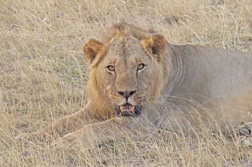
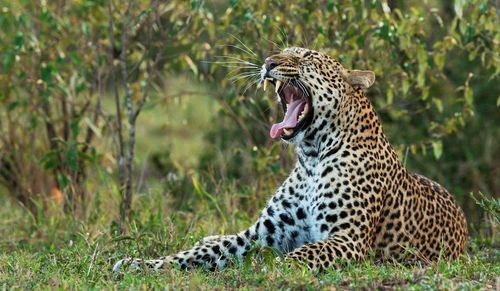
The vegetation on Mount Elgon is similar to Mount Kenya’s, and equally impressive, with bamboo and podocarpus forests (the latter more accessible than Mount Kenya’s) giving way to open moorland inhabited by the strange statues of giant groundsel and lobelia. The wildlife isn’t easily seen until you get onto the moors, but some elephant and a fair few buffalo roam the forest (be extremely wary of both). The best place to see elephants used to be the Elephant Platform north of Chorlim Gate, where herds congregated to browse on the acacias, but many were wiped out by poachers in the 1980s, and the remainder became reclusive. It’s very rare to see them at the Elkony caves, where they regularly used to gouge salt. The Kenya Wildlife Service is confident that poaching is now under control, and estimates the elephant population to be around two hundred. The lions have long gone and, though there are still leopards and servals, you’re not likely to see one. The primates are more conspicuous: blue monkeys and black-and-white colobus crash through the forested areas, troops of olive baboons patrol the scrub, and along the Kimothon River that forms the lower park’s northern boundary, there’s a scattering of rare de Brazza’s monkeys.