Galway city
Known for its festivals, music and bars, Galway (Gaillimh) is a vibrant, fun-loving city and, though it has few sights to visit, many people end up staying here longer than intended. Conveniently, history and leisure combine here. The pubs, many of which retain their original, huge fireplaces and other Gothic features, are the best place to get a feel for the medieval city.
As the capital of the Gaelic West – it’s the only city in the country where you might possibly hear Irish spoken on the streets – Galway draws young people from up and down the coast to study at the National University of Ireland at Galway and the Institute of Technology. In the summer holidays, however, its bohemian diversity becomes more overt, as hundreds of English-language students renew the city’s traditional maritime links with the Continent, while dozens of buskers from all over the world sing for their supper. Set to be the European Capital of Culture in 2020, the city streets of Galway will be even more electric with the buzz of music and the arts.
This cosmopolitan atmosphere is reinforced by the setting: Galway is the only coastal city in Ireland that really seems to open up to the sea, and its docks sit cheek by jowl with the compact city centre, as you’re constantly reminded by salty breezes and seagulls. The jewel in the city’s crown, the long, pedestrianized main drag of William, Shop, High and Quay streets, becomes a boisterous, Mediterranean-style promenade during summer, lined with pub and restaurant tables. At its lower, western end, the street narrows to its original medieval dimensions, then flows straight out into Galway Bay along with the thundering River Corrib, providing faraway views of the Burren hills of County Clare and a fitting introduction to an Ireland west coast tour.
A brief history
Strategically located in the narrow gap between Lough Corrib and the sea, Galway was little more than the site of a twelfth-century fort when it was captured from the Gaelic O’Flaherty clan in 1232 by the Anglo-Norman Richard de Burgo, who built a castle by the river. From the fifteenth century, the town was controlled by an oligarchy of mostly Anglo-Norman families, by the names of Athy, Blake, Bodkin, Browne, Darcy, Deane, Ffrench, Ffront, Joyce, Kirwan, Lynch, Martin, Morris and Skerrett. Cromwell later dubbed them the “Tribes of Galway”, an epithet which they adopted as a badge of honour – to this day, Galwegians nickname themselves the Tribesmen. Under this oligarchy, Galway grew wealthy as a largely independent city-state, far removed from the centres of power in Dublin and London but trading extensively with mainland Europe, especially Spain and France.
The town remained proudly loyal to the English Crown, but this only elicited harsh treatment when Cromwell’s forces arrived in 1652. Thereafter, Galway went into decline, exacerbated by the Williamite War later in the century, and fluctuating with the development of adjacent Salthill as a seaside resort in the early nineteenth century, the arrival of the railways and the building of navigable waterways to Lough Corrib in the 1840s and 1850s, alongside the depredations of the Great Famine. Growth returned in the late 1960s with industrial and tourism development, and Galway is now the fourth largest city in the Republic.
Festivals in Galway
The city’s biggest shindig is the two-week Galway Arts Festival in July, a volatile mix of drama, music, poetry, dance and the visual arts, with a headlining parade by flamboyant local street-theatre company Macnas. Hard on its heels, in late July or early August, comes the even headier brew of the Galway Races at Ballybrit, about 5km east of town, when farmers and politicians rub shoulders to party and bet. The diverse festival calendar also includes part of the Father Ted jamboree, Cúirt, an international festival of literature in late April (www.galwayartscentre.ie), the Galway Early Music Festival in late May (www.galwayearlymusic.com), the Galway Sessions of Irish and Scottish music in June (www.galwaysessions.com) and a prestigious, week-long cinema festival in early July, the Film Fleadh (www.galwayfilmfleadh.com). There’s a weekend jazz festival in mid-September (www.galwayjazzfestival.com), while at the end of September, the riotous, four-day Galway Oyster Festival (www.galwayoysterfest.com) includes the world oyster-shucking championships. Towards the end of the year, Baboró is an international arts festival for children in October (www.baboro.ie), while November’s TULCA is a festival of contemporary visual art (www.tulca.ie).
East Galway
East Galway is a vast tract of fertile, flat land bordered by the Shannon and its tributary the River Suck, the southern half of which shelters some compelling places to visit. The west’s first designated “heritage town”, Athenry, is a fascinating place to visit, while Kinvarra is a justly popular honeypot down on the shores of Galway Bay. Several historic attractions ring the town of Gort just inland, notably Coole Park, Lady Gregory’s idyllic woodland estate, and W.B. Yeats’s tower house, Thoor Ballylee. Out on a limb on the shores of Lough Derg, Portumna is an easy-going boating resort, with a fine castle and forest park, which gives access to Clonfert Cathedral, one of the country’s finest Romanesque churches.
East Galway Practicalities
The helpful tourist office (June–early Sept Mon–Fri 9.30am–1pm & 1.45–5pm; t 090/974 1910) is on Abbey Street, which runs parallel to and south of the main street, St Brendan’s Street (where Kearns Transport buses stop). If you’re so tempted by the water that you want to live on it for a week or two, contact Emerald Star, who rent out self-drive cruisers from the marina at the east end of town (t 071/962 7633, w www.emeraldstar.ie).
There’s plenty of accommodation in Portumna, including the swanky Shannon Oaks Hotel and Country Club (t 090/974 1777, w www.shannonoaks.ie; €151–200/£101–140; various packages and self-catering also available), which boasts a long list of facilities including a popular restaurant and bar, a twenty-metre swimming pool and gym, in spacious grounds at the west end of St Brendan’s Street. Just around the corner on St Brendan’s Road, welcoming Oak Lodge B&B (t 090/974 1549, w www.oaklodgeportumna.ie; €61–90/£41–60, good single rates) offers cheery, pine-furnished, en-suite rooms with free wi-fi, in a flower-bedecked modern bungalow; guests have full use of the leisure facilities at the Shannon Oaks.
The Beehive (open Tues–Sat daytime, Thurs–Sun eves; t 090/974 1830), a basic café-restaurant on St Patrick’s Street, just off the south side of the main street, serves salads, sandwiches, simple pastas and other main courses and cakes, plus tasty, popular pizzas in the evenings. Opposite is Dyson’s (t 090/974 2333; Wed–Sat evenings, Sun daytime; good-value set menu Wed–Fri, plus Sat until 6.30pm), a smart, pricey restaurant that rustles up such delights as rack of lamb with a cassoulet of cabbage, leeks and bacon. Among Portumna’s pubs, Horan’s (The Corner House), at the corner of St Brendan’s and St Patrick’s streets, is a likely sport for an impromptu session on any night.
The Aran Islands and the Gaelic Revival
In the late nineteenth century, the Arans became a living museum for anthropologists, antiquarians and linguists, seeking out the unbroken heritage of Gaelic language, beliefs and customs here, which in turn provided fuel for the Gaelic Revival and the Nationalist movement. Written and spoken Irish was a particular focus of interest, as even by this time the islands were one of the few areas of the country where the native language was in daily use. Patrick Pearse came specifically to learn Irish on Inishmaan, which was also visited by writers Yeats, Lady Gregory and, most notably, J.M. Synge – George Russell later joked that Synge’s knack was to discover that if you translated Irish literally into English, you achieved poetry.
The Arans themselves have nurtured several excellent writers, notably Liam O’Flaherty and poet Máirtín Ó Direáin, both from Inishmore. Meanwhile, the documentary-maker Robert Flaherty released his classic Man of Aran in 1934, in which he sought to record the islands’ vanishing way of life, though some of it had already disappeared – he wasn’t averse to recreating scenes that were no longer witnessed. A few of the traditions captured in the film still exist – you’ll still see people collecting seaweed for fertilizer, building dry-stone walls and fishing from currachs (traditional pointed skiffs), though these are no longer covered with animal skins.
Inishmaan
Approaching from the west or east, Inishmaan (Inis Meáin, “Middle Island”) looks like a rising wave about to break over Galway Bay to the north. From the grey, fissured limestone pavement at its northern end, tiny, green pastures separated by a maze of dry-stone walls rise to the main east–west ridge – along which lies a ribbon of villages – while the “back of the island” beyond slopes off more gradually to the south. This is the most unspoilt of the Arans, and the most thoroughly Irish-speaking (though English is understood), where people are still mostly engaged in farming and fishing. Wild salmon are caught from black, pointed currachs – now with outboard motors – and on Sundays, older women wear traditional multicoloured shawls to go with their thick woollen skirts. The island’s historic sites are on a smaller scale than Inishmore’s – though the imposing ring fort of Dún Conchúir is worth singling out – and there are far fewer amenities, but for some people this tranquil, low-key place will be the perfect getaway.
Inisheer
Lying just 10km off the Clare coast, Inisheer (Inis Oírr, “East Island”) is the smallest and least dramatic Aran. Its historic sites aren’t quite as appealing as Inishmaan’s, and it’s much more of a lively pleasure ground, attracting crowds of teenagers from the local Irish college and day-trippers from Doolin in summer. There’s a lovely, partly sheltered, sandy beach east of the pier on the north coast, along which nearly all of the habitation on this three-kilometre-wide island spreads.
Oughterard
Around 28km from Galway on the N59, OUGHTERARD is a busy little town, at the start of the Western Way, with plenty of varied attractions in the surrounding area to keep you occupied. Its main asset, however, is not immediately obvious from the long main street: behind the trees to the north of town lies the great expanse of Lough Corrib, a paradise for angling or for just messing about in boats, studded with hundreds of tree-clad islets (365 of them, one for each day of the year, if you believe the locals). May is the busiest time for fishing, when the mayflies hatch from the lake bed.
Connemara Practicalities
Good options for B&B include St Josephs (t 095/35865, w www.roundstonebandb.com; €61–90/£41–60), a cosy and welcoming en-suite place with great breakfasts in the heart of the village. Six kilometres northeast on the R341 towards the N59 is the upmarket Angler’s Return (t 095/31091, w www.anglersreturn.com; €91–120/£61–80), a tranquil and stylish 1820s sporting lodge set in pretty gardens. There are several campsites to the west of Roundstone, including the well-equipped Gurteen Bay Caravan Site beside the beach of the same name (t 095/35882, w www.gurteenbay.com; self-catering apartments, cabins and caravans available).
A couple of exceptional hotels enliven the harsh landscape to the northeast of Roundstone. Set on its own fishing river and lake towards the N59, eighteenth-century Ballynahinch Castle was once the home of Richard Martin – aka Humanity Dick – the animal-rights campaigner and co-founder of the RSPCA in 1824, and later of cricketing maharaja, Ranjitsinhji. It’s now a grand, romantic luxury hotel in a glorious estate setting, with an excellent restaurant and a cosy fisherman’s bar where good food is also available; activities include tennis, cycling and guided walks (t 095/31006, w www.ballynahinch-castle.com; various packages and offers available; €201–250/£141–170). Near the village of Cashel, about a fifteen-minute drive round the bay from Roundstone, Cashel House Hotel (t 095/31001, w www.cashel-house-hotel.com; closed Dec; €201–250/£141–170), is an elegant country house set in varied and beautiful gardens.
The best place to eat and drink in Roundstone is lively, sociable O’Dowd’s (t 095/35809), which serves excellent bar food; attached to the pub is a fine evening-time restaurant and O’Dowd’s Café, offering good coffee, salads, pizzas, seafood chowder and internet access. Ferron’s Supermarket contains a post office and ATM. The village also hosts a hooker regatta in July and Summerfest in mid-August (w www.roundstonesummerfest.com).
Clifden
CLIFDEN, the English-speaking capital of Connemara, is a popular, animated service town for both tourists and locals, enhanced by a spectacular setting: it perches on a steep, verdant hillside, where the lofty, grey spires of the Catholic and Anglican churches compete for attention, while on its western side the land plunges abruptly down to the deeply indented harbour. Several stately townhouses sprinkle the three major streets – Main Street, the continuation of the Galway road culminating in Market Square, with Bridge Street and Market Street branching off it at either end and meeting to form a rough triangle (the one-way system runs clockwise from Bridge to Market to Main streets). By basing yourself in one of the town’s fine accommodation options, you’ll be able to explore the varied attractions of coast and mountain hereabouts – especially if you have your own car or are prepared to hire a bike – and return to sample the often lively nightlife.
Inishbofin
INISHBOFIN continues the diversity of the Connemara landscape into the sea, though in a gentler, miniature format. Just 5km wide, the island encompasses cliffs and the rocky outcrops known as The Stags on its western side, tranquil, reedy Lough Boffin, the haunt of swans, at its centre, and several sandy beaches, but rises only to 90m at its highest point, Cnoc Mór, which is carpeted by a springy layer of grass. This all makes for gentle, low-key exploration, complemented by a choice of good accommodation and plenty of traditional music, featuring the island’s own renowned ceilidh band.
Walking in Connemara
Connemara offers a fantastic variety of walking, including mountains over 700 metres – though remember the nearest rescue team is in Galway. A good map and guidebook for serious walkers is The Mountains of Connemara, available from local bookshops and tourist offices, with a 1:50,000 scale map derived from aerial photography and fieldwork by Tim Robinson, and an excellent guide to eighteen walks of varying length and difficulty by Joss Lynam. The Ordnance Survey has recently resurveyed the area, producing their own maps at 1:50,000.
A good introduction to the Maam Turks, with fantastic views of the Twelve Bens across Lough Inagh, would be the ascent of Cnoc na hUilleann and Binn Bhriocáin from the Inagh Valley back road north of Recess, on a three- to four-hour circuit described in The Mountains of Connemara (part of it on the Western Way). Also described are the classic Twelve Bens walk, the seven-hour Gleann Chóchan Horseshoe, starting from the Ben Lettery youth hostel and bagging six of the peaks; and the tough, high-level Maam Turks Walk, which traverses the range from north of Maam Cross to Leenane – it can be done in one very long day, but most people will want to do it in two, staying down in the Inagh Valley.
Mountains of Connemara also covers the waymarked Western Way, which runs for 50km from Oughterard to Leenane. This varied, low-level trail starts as a pleasant, sometimes boggy walk beside Lough Corrib, before crossing over from the village of Maam into the dramatic Inagh Valley, which runs between the Bens and the Turks. The walk can be done in two long days, with an overnight near Maam, or in the Inagh Valley.
Worthy short walks include the ascent of Errisbeg and other routes near Roundstone as described, the sky road from Clifden, a circuit of Inishbofin, the excellent trails at Connemara National Park and the climb up Tully Hill.
Inishmore
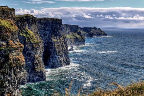
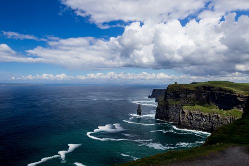
One of the great attractions of Inishmore (Inis Mór, “Big Island”, but often referred to simply as Árainn) is its topography, stark, simple and easily appreciated. Sheer cliffs run the fourteen-kilometre length of its south coast, lashed at their base by the relentless Atlantic, while their tops offer an ethereal panorama, the echoing wall of the Cliffs of Moher to the southeast, and to the north across Galway Bay, the Connemara Mountains, tinged with green, purple and gold. The land declines northwards in a geometric pattern of grey stone, the parallel grooves of its limestone pavement overlaid by ten thousand kilometres of dry-stone walls, which parcel up man-made fields, painstakingly nurtured out of sand, seaweed and what handfuls of soil there are. There’s more greenery and a smattering of villages towards the sheltered north coast, which is lined with rock pools and several sandy beaches.
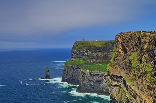
This landscape is strewn with a wealth of spectacular dry-stone ring forts, notably Dun Aengus, and fascinating early churches. Consequently, and with frequent bus and boat links to Galway city, Inishmore receives crowds of day-trippers in the summer and is the most tourist-oriented of the Arans, now even boasting a branch of Supermac’s, Ireland’s very own burger chain. However, you really need two full days to visit the historic sites, which will also allow you time to soak up the scenery, enjoy the relative quiet of the evenings here and even have a swim at beautiful Kilmurvey beach.
Signposted to the south of Kilmurvey, Dun Aengus is by far the Aran Islands’ most compelling ancient site, a semicircular fort of three concentric enclosures, hard up against the edge of sheer, ninety-metre sea cliffs. From here, you can see Kerry Head, northwest of Tralee, on a clear day and occasionally Mount Brandon on the Dingle Peninsula – and if you’re truly blessed the island of Hy Brasil to the west. The fort is named after Aengus of the Fir Bolg, a legendary ancient race, who were said to have been of Greek origin and to have ruled Ireland for 37 years, before being conquered by the equally mythical Tuatha Dé Danann.
From Dun Aengus, you might be lucky enough to see the famous mirage known as Hy Brasil (after which the South American country was supposedly named), which appears in the sea to the west as a mountainous island. Local folklore represents this mythical land variously as the island of the blessed, the Garden of Eden, Tír na nÓg (the land of eternal youth), the Isle of Truth, of Joy, of Fair Women and of Apples. In the early twentieth century, islanders believed it appeared once every seven years, but up until the mid-nineteenth century it was actually shown on some sea charts of the Atlantic. On the unforgiving, sea-battered Arans, it’s easy to understand how this fantasy of a prosperous paradise grew up.
Planning a trip? Find out the best ways to get to Ireland.