Donegal Travel Guide

Second in size only to County Cork, County Donegal has unquestionably the richest scenery in the whole of Ireland, featuring a spectacular three-hundred-kilometre coastline – an intoxicating run of headlands, promontories and peninsulas rising to the highest sea-cliffs in Europe at Slieve League. Inland is a terrain of glens, rivers and bogland hills, of which the best-known destinations are the Glencolmcille Peninsula and around Ardara and Glenties in the southern part of the county. The Glencolmcille area attracts more visitors than any other, yet the landscape of northern Donegal is, if anything, even more satisfying, especially the Rosguill and Inishowen peninsulas (though certain parts have been blighted by ugly, modern housing developments) and the interior region around Errigal Mountain, Lough Beagh and Lough Gartan. Other noteworthy areas are the Rosses and Gweedore, which are reminiscent of the more barren stretches of Connemara and make up the strongest Irish-speaking districts in the county.

Donegal’s original name was Tír Chonaill, which translates as “the land of Conal”; Chonaill was one of the twelve sons of Niall of the Nine Hostages, reputed to have ruled Ireland in the fifth century. After the Flight of the Earls in 1607, the English changed the name to that of their main garrison Dún na nGall (“fort of the foreigners”), which has a certain irony, because Donegal always eluded the grip of English power thanks to its wild and infertile terrain. Donegal is the most northerly part of Ireland, which confuses some into believing that it is part of Northern Ireland. It never actually has been, since in 1922, at the time of Partition, the Unionists believed that Donegal’s Catholic population would threaten the stability of the new statelet by voting the county and the whole of the North back into the Republic.

South Donegal

Entered via the N15 from Sligo (which now largely bypasses the most scenic spots), South Donegal might lack the wildness characteristic of much of Donegal’s coastline, but the area still has some marvellous beaches, especially at Bundoran and Rossnowlagh, both popular surfing spots, while Ballyshannon is an attractive hillside town situated at the mouth of the River Erne. Further north, Donegal town has a pleasant bayside setting and remains of a notable castle, while to its north and southeast respectively lie graceful Lough Eske and Lough Derg, a major site for Catholic pilgrimage.

The Annals of the Four Masters

In Donegal town’s Diamond stands an obelisk commemorating the compilers of the famed Annals of the Four Masters. The Annals were begun in the town’s Franciscan friary, whose ruined remains stand on the left bank of the River Eske, and were a systematic attempt to collect all known Irish documents into a history of the land beginning in 2958 BC, including mythical invasions by Firbolgs and Milesians, and ending in 1616 AD. The friary itself was built in 1474 by the first Red Hugh and his wife Nuala O’Brien of Munster. It was occupied by the English in 1601 and seriously damaged by the besieging O’Donnell army, being finally abandoned after the Flight of the Earls. The Annals were completed by friars who had moved to a site by the River Drowse, near Kinlough, Country Leitrim. Manuscript copies of the Annals are occasionally on display at Trinity College library in Dublin.

Getting to South Donegal

Buses stop outside the Abbey Hotel on The Diamond, with timetables available from the tourist office in its new waterside building in The Quay car park (Sept–May Mon–Fri 9.30am–5.30pm; June–Aug Mon–Fri 9am–6pm, Sat 10am–6pm; also July & Aug Sun 11am–3pm; t 074/972 1148). Internet access is available at the Cyber Café, above The Blueberry Tearooms, Bridge Street. Bikes can be rented from The Bike Shop, Waterloo Place (t 074/972 2515).

Accommodation in South Donegal

Donegal town has plenty of accommodation, including a staggering number of B&Bs, in all price ranges, so you should have no difficulty finding somewhere to stay; nearby Lough Eske has other options.

Eating in South Donegal

Eating places are plentiful in Donegal town, though for something special it’s best to head out to Harvey’s Point.

South Donegal drinking and nightlife

Donegal holds a summer festival in early July with plenty of music and street entertainment. Many of the town’s pubs offer entertainment year-round, and Thursday’s Donegal Democrat newspaper provides local listings.

Opposite the castle, The Reel Inn has traditional music every night. At the top of Main Street The Schooner, just past the cathedral, has a nautical interior, an original nineteenth-century bar and music at weekends. For a quiet pint, try Tírconaill, an old-time bar on The Diamond.

Southwest Donegal

The most appealing route out of Donegal town heads west along the shore of Donegal Bay all the way to Glencolmcille, some 50km away. Highlights along this coast include the tapering peninsula leading to St John’s Point and extraordinarily dramatic coastal scenery, which reaches an apogee in the mammoth sea-cliffs of Slieve League. The Glencolmcille Peninsula is a Gaeltacht (Irish-speaking area) and its attractive villages are rich in traditional folklore and music.

Glencolmcille and around

As the road from Carrick approaches GLENCOLMCILLE, it traverses desolate moorland that’s dominated by oily-black turf banks amidst patches of heather and grass. After this, the rich beauty of the Glen, as it’s known, comes as a welcome surprise. Settlement in the area dates back to the Stone Age, as testified by the enormous number of megalithic remains scattered around the countryside, especially court cairns and standing stones. There’s evidence, too, of the Celtic era, in the form of earthworks and stone works. According to tradition, St Columba founded a monastery here in the sixth century and some of the standing stones, known as the Turas Cholmcille, were adapted for Christian usage by the inscription of a cross. Every Columba’s Day (June 9) at midnight, the locals commence a barefoot circuit of the fifteen Turas, including Columba’s Chapel, chair, bed, wishing stone and Holy Well, finishing up with Mass at 3am in the village church. (Columba and Columbcille/Colmcille are the same person – the latter is the name by which he was known after his conversion, and means “the dove of the church”.)

Heading northeast from Glencolmcille, the minor road to Ardara runs through the heart of the peninsula, travelling via the dramatic Glengesh Pass before spiralling down into wild but fertile valley land. Just before reaching Ardara, a road to the left runs along the southern edge of Loughros Beg Bay for 9km to MAGHERA, passing the transfixing Assarancagh Waterfall, from where you can embark on a hardy ten-kilometre waymarked walk uphill to the Glengesh Pass.

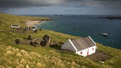
Maghera itself is an enchantingly remote place, dwarfed by the backdrop of hills and glens and fronted by an expansive and deserted strand that extends westwards to a rocky promontory riddled with caves. One of the largest is said to have concealed a hundred people fleeing Cromwell’s troops; their light was spotted from across the strand and all were massacred except a lucky individual who hid on a high shelf. Most of the caves are accessible only at low tide and a torch is essential. Beware of the tides, however, as even experienced divers have been swept away by the powerful currents. Behind the village, a tiny road, unsuitable for large vehicles, runs up to the Granny Pass, an alternative and very scenic route to Glencolmcille.

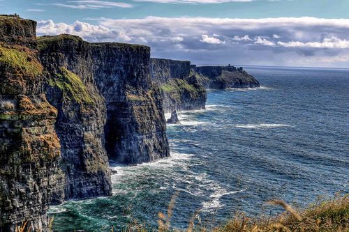
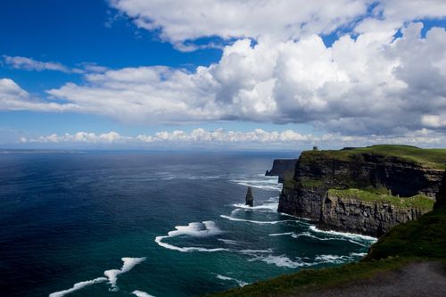
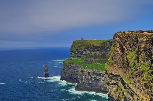
Climbing Slieve League

There are two routes up to the ridge of Slieve League. The less-used back one, known as Old Man’s Track, follows the signpost pointing to the mountain just before Teelin and looks up continually to the ridge, while the frontal approach follows the signs out of Teelin to BUNGLASS, swinging you spectacularly round sharp bends and up incredibly steep inclines to one of the most thrilling cliff scenes in the world, the Amharc Mór. The sea moves so far below their peak that the waves appear silent, and the 600m face glows with mineral deposits in tones of amber, white and red. They say that on a clear day it is possible to see one-third of the whole of Ireland from the summit. Sightseeing tours of the cliffs from the waters below are organized from Teelin, weather permitting.

If you want to make a full day of it, you can climb up to the cliffs from the Bunglass car park and follow the path along the top of the ridge, which eventually meets Old Man’s Track. From here One Man’s Pass, a narrow path with steep slopes on each side, leads up to the summit of Slieve League. Bear in mind that the route can often be muddy and very windy – it is certainly not advisable in misty weather or if you suffer from vertigo. From the top of Slieve League, you can either retrace your steps back to Teelin or continue west over the crest of the mountain and down the heather-tufted western slope towards the verdant headland village of MALINBEG, where there’s a sublime, crescent-shaped golden strand enclosed by a tight rocky inlet. Malinbeg itself is a village of white bungalows, with the land around ordered into long narrow strips. The Malinbeg hostel is comfortable and well-equipped and offers exhilarating views from most of its rooms. On the cliff edge a ruined Martello tower faces Rathlin O’Beirne Island, 5km offshore, a place with many folklore associations. There are occasional boats across (enquire in Teelin), but nothing to see aside from some early Christian stone relics and a ruined coastguard station.

Beyond Malinbeg, it’s relatively easy to extend your walk through MALINMORE and on to Glencolmcille. The whole distance from Teelin to Malinmore can be comfortably completed in six hours.

Central Donegal

The area around the bustling town of Ardara contains some of the most contrasting landscapes in Donegal. Rugged mountains lie to the southwest, traversed by the steeply sinuous Glengesh Pass and fringed by the unspoiled expanse of Maghera strand. Inland to the northeast sits the stately village of Glenties, while to the north the coastline forms peninsulas punctuated by the Gweebarra River, which, in turn, leads inland to the tranquil villages of Doocharry and Fintown, virtually surrounded by mountain scenery of an almost lunar quality.

Ardara

Lively ARDARA, traditionally a weaving and knitwear centre, is an excellent place to buy cheap Aran sweaters. Molloy’s, a kilometre south of town, is the biggest outlet, but Kennedy’s, uphill from The Diamond, is handier (its owner is also a mine of local tourist information); both stores are well stocked with hand-loomed knitwear and tweeds. The Catholic church west of Ardara’s Diamond has a striking stained-glass window, Christ among the Doctors, by the Modernist-inspired Evie Hone, one of the most influential Irish artists of the twentieth century. The authors of the Gospels are depicted symbolically with the infant Christ at the centre and David and Moses above and below.

Glenties

Set at the foot of two glens 10km east of Ardara, GLENTIES is a tidy village, with a beautiful modern church, at the Ardara end of town, designed by the Derry architect Liam McCormack; its vast sloping roof reaches down to 2m from the ground, and rainwater drips off the thousand or so tiles into picturesque pools of water. Opposite the church, St Conall’s Museum and Heritage Centre is one of the best small-town museums in the country and displays much material of local interest, focusing on wildlife, Donegal’s railways, antiquities, and the effects of the Great Famine. There’s a special display on local music, featuring the travelling Doherty family and an old 1885 Edison phonograph. Upstairs is devoted to the playwright Brian Friel, whose mother hailed from here – his Dancing at Lughnasa bears a dedication to “The Glenties Ladies” and was partly filmed in the neighbourhood – and the town’s most famous son, author Patrick MacGill, whose semi-autobiographical Children of the Dead End brilliantly recounts the wayward lives of migrant navvies: a summer school is held in his honour in late July, attracting hundreds of people to its exhibitions, seminars and literary debates.

The Rosses

The Rosses, a vast expanse of rock-strewn land and stony soil, is a strong Gaeltacht area. Dotted with over 120 tiny lakes, the crumpled terrain stretches from Dungloe in the south to Crolly in the north, but the forbidding nature of much of the landscape meant most settlements could only survive near the sea, so following the shoreline route around the Rosses is far more rewarding than the more direct road north.

Gweedore and Tory Island

Like its southern neighbour, the Rosses, the interior of the Gweedore district is largely desolate and forbidding country, and settlements again cling to the shoreline. To the southwest lie the villages of Bunbeg and Derrybeg, their cottages sprinkled across a blanket of gorse and mountain grasses. The ruggedness intensifies as it continues up the coast and round the Bloody Foreland to Gortahork in the Cloghaneely district, yet surprisingly, there has been significant house-building here and the area is quite densely populated. Some distance offshore lies Ireland’s most literally isolated community, Irish-speaking Tory Island, a place rich in folkloric and musical traditions.

The Derryveagh Mountains and Glenveagh

Inland from Gweedore lies some of the most dramatic scenery in Donegal, an area dominated by mountains such as Errigal and Slieve Snaght and loughs of startling beauty. This is popular hill-walking country, especially along the Poisoned Glen, part of the much-visited Glenveagh National Park. Further on, towards Letterkenny, the countryside becomes gentler and increasingly verdant, especially in the environs of Lough Gartan, an area rich in associations with St Columba.

Mount Errigal

Heading east on the N56 from Gweedore, the imposing and starkly beautiful mass of Mount Errigal becomes increasingly prominent. From a distance the mountain appears to be snow-covered, but skirting the northern shore of Lough Nacung, it becomes apparent that the white colouration has geological, rather than meteorological, causes. Quite often the area around Errigal is shrouded in mist, but on a clear day the beauty of the mountain is unsurpassable, its silvery slopes resembling the Japanese artist Hokkusai’s images of Mount Fuji. The hour-long hike up to the top is a must, and there’s a waymarked trail from the road, 2km past the Poisoned Glen turn-off, up the southeast ridge. The climb to the summit is well worth it for the stupendous views: virtually all of Donegal, and most of Ulster, is visible and you could easily spend several hours just sitting and absorbing the contrasts provided by coastline, loughs and mountains.

Lough Gartan

The environs of Lough Gartan are one of the supreme beauties of Ireland. St Colmcille was born into a royal family here in 521; his father was from the house of Niall of the Nine Hostages and his mother belonged to the House of Leinster. If you walk over from Glenveagh you’ll pass his birthplace – take the first road right at the first house you see at the end of the mountain track, and you’ll come to a colossal cross marking the spot; the site is also signposted from the road running along the lough’s southern shore. Close by is a slab known as the Flagstone of Loneliness, on which Colmcille used to sleep, thereby endowing the stone with the miraculous power to cure the sorrows of those who also lie upon it, though nowadays it’s bestrewn with coins. During times of mass emigration, people used to come here on the eve of departure in the hope of ridding themselves of homesickness. Archeologically, it’s actually part of a Bronze Age gallery tomb and has over fifty cup marks cut into its surface.

Glebe House

Glebe House is a gorgeous Regency building set in beautiful gardens on the northwest shore of Lough Gartan. Richly decorated both inside and out, it owes its fame to the time of its tenure by the English artist Derek Hill (1916–2000), though it’s now run as a gallery by the Heritage Service. The converted stables are used for visiting exhibitions, while the rooms of the house itself display a rich collection of paintings, sketches and numerous other items once owned by Hill, including works by Kokoschka, Yeats, Renoir and Picasso. The study is decked out in original William Morris wallpaper and there are Chinese tapestries in the morning room. The kitchen has various paintings by the Tory Island group of primitive painters, most remarkably James Dixon’s impression of Tory from the sea.

The north Donegal coast

Running from the Cloghaneely district, which adjoins Gweedore, the north Donegal coast holds some of the most spectacular scenery in the whole country, where the battle between the elements is often startlingly apparent. Overshadowed at first by the bleak beauty of Muckish Mountain to the south, the main road from Gortahork to Milford passes through verdant countryside as it meanders around the deep bays and inlets and alongside the glorious and often deserted beaches which punctuate the shoreline. On the way, the Plantation town of Dunfanaghy provides a good base for exploring one of the coastline’s two breathtaking peninsulas: Horn Head, with its rugged, sea-battered cliffs; and, further to the east, Rosguill, almost circumscribed by the marvellous Atlantic Drive.

The Rosguill Peninsula

The route onto the extremely beautiful and very manageable Rosguill Peninsula starts by the side of the church in Carrigart, 13km northeast of Creeslough, and passes rabbit-infested dunes at the back of a tremendous and usually deserted beach. At the top of the strand is DOWNINGS, a sprightly holiday centre patronized mainly by Northern Irish tourists, with caravan sites hogging the rear end of the beach and holiday chalets creeping up the hillside behind the village. Downings’ main street heads northwards to become the panoramic Atlantic Drive, which runs around the headland and also makes for a stupendous thirteen-kilometre walk. The range of views encompasses the essence of Donegal – rugged landscapes in constant tussle with the Atlantic Ocean – though, sadly, this is becoming increasingly blighted by large numbers of new-build houses and caravan sites.

The Fanad Peninsula

The least tempting of Donegal’s peninsulas is Fanad, circumnavigated by the well-signposted Fanad Drive. However, the western shoreline has little to offer scenically, and the whole peninsula is best approached along the eastern coast road from Letterkenny through the pleasant towns of Ramelton and Rathmullan, the latter with some very swish accommodation, before heading on to Fanad Head itself.

Letterkenny and around

Whatever your means of transport, if you’re travelling through northern Donegal, you’re almost certain to pass through the county’s largest town, LETTERKENNY, with its lively arts scene and thriving nightlife. The gently rolling countryside south of Letterkenny is probably the least visited of any populated area in the county, but includes a major Stone Age site near Raphoe and a couple of enticing lures at Lifford.

The Inishowen Peninsula

The Inishowen Peninsula in the northeast of County Donegal is perhaps the great overlooked treasure of the Irish landscape (and certainly has the longest signposted scenic drive – the “Inishowen 100”), offering a diverse and visually exciting terrain, where the views usually encompass the waters of the loughs or the Atlantic waves. Virtually every aspect of the landscape is superb – the beaches (especially Kinnego Bay, Culdaff, Tullagh and Pollan), the towering headland bluffs (Malin, Inishowen, Dunaff and Dunree) and the central mountain range, with towering Slieve Snaght at the middle of it all.

The peninsula derives its name from Eoghán, who was made First Lord of the island by his father Niall, High King of Ireland. Phases of the peninsula’s history before and after Eoghán have left a legacy of fine antiquities, from the Grianán Ailigh fort to a host of beautiful early Christian crosses (Cloncha, Mura, Carrowmore and Cooley).

The Grianán Ailigh

Off the N13 Letterkenny–Derry road lies the ancient fort known as the Grianán Ailigh. It dates from 1700 BC, and is thought to be linked to the Tuátha Dé Danann, pre-Celtic invaders. It was sufficiently significant to be included by Ptolemy, the Alexandrian geographer, in his second-century AD map of the world, and was the base of various northern Irish chieftains. Here, in 450, St Patrick is said to have baptized Eoghán, the founder of the O’Neill clan that ruled the kingdom of Ailigh for more than five hundred years. In the twelfth century, the fort was sacked by Murtagh O’Brian, King of Thomond, in retribution for a raid on Clare, and a large amount of its stone was carried away. Today’s impressive building was largely reconstructed in the 1870s by Walter Bernard from Derry and is the only remaining terraced fort in Ireland. It’s enclosed by three earthen banks, but its most stunning asset is the view across the primordial jumble of mountains and hills far away to the west and the loughs to each side of Inishowen immediately to the north.

Malin and Malin Head

Five kilometres north of Carndonagh is the planter settlement of MALIN, tucked picturesquely into the side of Trawbreaga Bay, with a charming grassy Diamond at its centre. The village has a couple of pubs, and the boutique-style Malin Hotel, which hosts a variety of entertainment and has a very good restaurant. A little way north of Malin, a signpost points to Five Fingers Strand, across the bay from Doagh Isle – it’s worth the diversion to experience the ferocity of the breakers on the beach and the long walks on its sands, though the strand has undergone recent severe coastal erosion.

Sixteen kilometres north of Malin village, Malin Head, the northernmost extremity of Ireland, might not be as stupendous as other Donegal headlands but is nevertheless excellent for blustery, winding coastal walks – and for ornithologists: choughs, with their glossy black plumage, red legs and bill, inhabit the cliffs, and the rasping cry of the rare corncrake can be heard in the fields. The tip of the headland is marked by Bamba’s Crown, a ruined Napoleonic signal tower, and the western path from here heads out to Hell’s Hole, a 75-metre chasm in the cliffs, which roars with the onrushing tide.

Horn Head

Horn Head is magnificent, an almost two-hundred-metre rock face scored by ledges on which perch countless guillemots and gulls and small numbers of puffins. The best view of the cliffs, sea-stacks and caves is from the water, but the cliff road is vertiginous enough in places to give you a good look down the sheer sides. To get here take the slip road at the western end of DUNFANAGHY village; it descends to skirt the side of a beautiful inlet before rising steeply to go round the east side of the head. A spectacular vista of headlands opens up to the east – Rosguill, Fanad and Inishowen – but none can match the drama of Horn Head’s cliffs, their tops clad in a thin cover of purplish heather. Alternatively, you can walk from Horn Head Bridge, 800m from Dunfanaghy on the Horn Head road, and head west across the dunes to Tramore Beach. Then follow the sheep track north, passing two small blowholes called the Two Pistols and then a much larger one, McSwyney’s Gun, so called because of the power of the sonic boom produced by the explosion of compressed air from the cavern. Erosion has occurred over the years, however, and you’ll be lucky to hear anything these days. Continuing onwards, you’ll come to Pollaguill Bay and beach. The next wondrous site is the more than twenty-metre high Marble Arch, cut by the sea through the base of Trawbreaga Head. Horn Head itself soon becomes visible as you ascend the next headland.

The walk as far as here takes around three hours from Dunfanaghy and you can either complete the whole circuit of the peninsula or head back by road.

Tory Island

With its ruggedly indented shores pounded by the ocean, TORY ISLAND, though only 12km north of the mainland, is notoriously inaccessible. Only 4km long and less than 1.5km wide, its vulnerability to the elements means little can grow here. Yet despite the island’s barren landscape and the ferocity of the elements, the Tory islanders are thriving, a situation no one could have predicted thirty years ago. Back then, conditions on the island were very poor, lacking essential amenities such as a water supply, proper sanitation, reliable electricity and a ferry service. The arrival of a new priest, Father Diarmuid Ó Péicín, in the early 1980s stimulated a transformation. Rallying the islanders, the pastor began to lobby every possible target, securing backing from such disparate characters as the US senator Tip O’Neill (who had Donegal ancestry) and Ian Paisley. The campaign attracted media attention and conditions gradually began to improve. Nowadays, around 160 people live permanently on the island and 25 children attend the local junior school, a happy sign of the island’s revival (older children spend term times in Falcarragh).

Some history

According to local mythology, Tory was the stronghold of the Fomorians, who raided the mainland from their island base and whose most notable figure was the cyclops Balor of the Evil Eye, the Celtic god of darkness. Intriguingly, the local legend places his eye at the back of his head. There’s also said to be a crater in the very heart of the island that none of the locals will approach after dark, for fear of incurring the god’s wrath. In the sixth century, St Colmcille landed on Tory with the help of a member of the Duggan family. In return, the saint made him king of the island; the line has been unbroken ever since and you’re more than likely to meet the present king, Patsy Dan Rodgers, who regularly greets arrivals at the harbour. Some monastic relics from St Columba’s time remain on Tory, the most unusual of which – now the island’s emblem – is the Tau Cross. Its T-shape is of Egyptian origin, and is one of only two such monuments in the whole of Ireland. It has now been relocated and set in concrete on Camusmore Pier in West Town, one of the island’s two villages. There are other mutilated stone crosses and some carved stones lying around, several by the remains of the round tower in West Town, which is thought to date from the tenth century and is uniquely constructed from round beach stones. A local superstition focuses on the wishing stone in the centre of the island, three circuits of which will supposedly lead to your desires being granted.

Tory Island's artists

Tory islanders are famed for their painting, a development that originated in a chance encounter between the English painter Derek Hill and one of the island’s fishermen, James Dixon, in 1968, both now deceased. Dixon had never lifted a brush before the day he told Hill that he could do a better job of painting the Tory scenery, but he went on to become the most renowned of the island’s school of primitive painters – Glebe House has a remarkable painting by him. You can view the islanders’ work and, more than likely, meet the artists, at the James Dixon Gallery, the originator’s former home, a little way to the east of the harbour.

Planning your own trip? Prepare for your trip

Use Rough Guides' trusted partners for great rates

Rough Guides Editors

written by Rough Guides Editors

updated 26.04.2021

Ready to travel and discover
Ireland?

Get support from our local experts for
stress-free planning & worry-free travels

Plan my trip ⤍