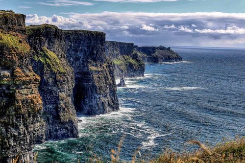
Around Dublin: Wicklow, Kildare and Meath Travel Guide

The modern counties of Wicklow, Kildare and Meath equate roughly – Wicklow’s wild mountains were always something of a no-man’s-land – with the Pale, the fortified area around Dublin to which the English colonists retreated after 1300. The colonists coined the expression “beyond the pale” and implanted the language, customs and government of lowland England in these “obedient shires”, leaving today’s visitors a rich architectural legacy of castles, abbeys and, from a later period, stately homes. Wicklow, Kildare and Meath are much sought after by modern-day settlers, too: unable to afford Dublin’s property prices, thousands of the capital’s workers have set up home in the hinterland in the last fifteen years, though the outward sprawl has been checked by the recent economic crisis.

Book things to do in Dublin

County Wicklow is sometimes nicknamed the “Garden of Ireland”, but apart from the narrow, fertile coastal strip, this is no gentle hinterland to the capital. It was the extreme desolation of the mountains that drew the hermit St Kevin to his cave at Glendalough, around which one of Ireland’s most prominent and charismatic monastic sites grew up. The Rebellion of 1798 was sustained longest by its Wicklow insurgents, some of whom made the best of their upland fastness to evade capture until 1803. To flush them out, the authorities in Dublin were obliged to build a military road, fortified by barracks, into the mountains, which remains the principal route along the backbone of the range to this day. Not surprisingly, wealthy English and Irish landowners built their great country houses around the edges of the mountains, of which fine examples at Powerscourt, Russborough and Avondale are now open to visitors.

In contrast to the harsh landscape of the Wicklow Mountains to the east, County Kildare is prosperous farming country, which was gladly seized and fortified by the English as part of the medieval Pale. Rich pasture for cattle and horses in the north of the county gives way to fertile ploughland in the south, the Bog of Allen in the northwest providing the only unproductive blot on the landscape. The county’s main attractions for visitors are neatly concentrated in two areas. Servicing the bloodstock farms on the Curragh’s lush heathland, Kildare town is generally a low-key affair, where you can explore the monastery and church founded by St Brigid in the fifth century, and see what all the equine fuss is about at the fascinating National Stud. To the north of town, you can trace the development of the Bog of Allen at the nature centre in Lullymore. Meanwhile up on the county’s northern edge lie the motley attractions of Larchill Arcadian Gardens, as well as one of Ireland’s finest stately homes, Castletown.

The rich limestone lowlands of County Meath, bisected by the River Boyne and supporting ample cattle pasturage, have always attracted settlers and invaders. The valley’s Neolithic people somehow found the resources and manpower to construct the huge, ornately decorated passage graves of Newgrange, Knowth and Dowth, part of the extraordinary landscape of ritual sites known as Brú na Bóinne, which is today one of the country’s most famous and best organized visitor attractions. In contrast, the Loughcrew Cairns, a similarly extensive grouping of burial mounds in the far northwest corner of the county beyond the small market town of Kells, have failed to garner present-day resources for excavation and tourist development, leaving you to explore this mysterious, hilltop landscape unaided and usually in solitude. The Hill of Tara started out as a Stone Age cemetery, too, but evolved into one of Ireland’s most important symbolic sites, the seat of the High Kings of the early Christian period. Meath also caught the eye of the Anglo-Norman invaders, who heavily fortified and held several parliaments at Trim, where you can visit the mighty castle and several other well-preserved medieval remnants. Meath’s other noteworthy sights are on either side of Brú na Bóinne in the northeast of the county: to the west Slane’s historic castle and monastery, which enjoy a picturesque setting on a steep, wooded hillside above the River Boyne; and to the east, the site of one of the most significant battles in Ireland’s history, the Battle of the Boyne, now commemorated by a high-tech visitor centre.

The Wicklow coast

County Wicklow’s main draw is without doubt the stunning scenery of the inland mountains, but the coast can offer some very attractive beaches, notably at Brittas Bay, south of Wicklow town, and is easily accessible from Dublin. The N11 runs the length of the county roughly parallel to the sea, while by train, the DART service runs as far as Bray and Greystones, and the scenic mainline to Enniscorthy, Wexford and Rosslare Harbour stops at Bray, Greystones and Wicklow town. Keen to maintain its independence from Dublin, Bray is a lively, sometimes rowdy, resort and commuter town, which offers an expansive beach and the finest walk along this coast, across Bray Head to the village of Greystones. Halfway down the county’s seaboard, Wicklow town enjoys a fine setting and a good choice of upmarket places to stay – if you have your own transport, this would make a good base for exploring the mountains. Concentrated in the coastal strip, the Wicklow Gardens Festival runs from Easter to September every year, when a wide variety of privately owned gardens throw open their gates to the public (wwww.visitwicklow.ie/gardens).

Book tickets and tours in Wexford

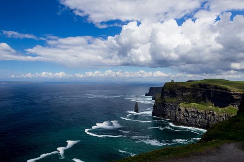
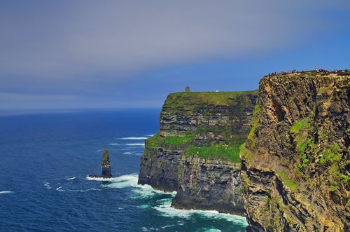
A walk over Bray Head to Greystones

There’s an excellent two- to three-hour walk from Bray seafront south across Bray Head to Greystones, a small commuter town at the end of the DART line with several pubs serving food. You can follow the comparatively flat cliff path that runs above the rail tracks for most of the way, giving close-up views of rocky coves and slate pinnacles, lashed by magnificent waves on windy days. Alternatively, if you have more time, take on the steep climb over the top of Bray Head for great views of Killiney Bay and the cone-shaped hills inland known as Little Sugar Loaf and Great Sugar Loaf, with a distant backdrop of the Wicklow Mountains. The latter route ascends rapidly from the end of Bray seafront through pine woods and over gorse slopes to a large cross, 200m above sea level, which was erected to mark the Holy Year of 1950; from here a track winds across the ridge below the 240-metre summit of Bray Head, before you turn sharp left down to join the cliff path which will bring you into Greystones.

County Kildare

In contrast to the harsh landscape of the Wicklow Mountains to the east, County Kildare is prosperous farming country, which was gladly seized and fortified by the English as part of the medieval Pale. Rich pasture for cattle and horses in the north of the county gives way to fertile ploughland in the south, the Bog of Allen in the northwest providing the only unproductive blot on the landscape. The county’s main attractions for visitors are neatly concentrated in two areas. Servicing the bloodstock farms on the Curragh’s lush heathland, Kildare town is generally a low-key affair, where you can explore the monastery and church founded by St Brigid in the fifth century, and see what all the equine fuss is about at the fascinating National Stud. To the north of town, you can trace the develop- ment of the Bog of Allen at the nature centre in Lullymore. Meanwhile up on the county’s northern edge lie the motley attractions of Larchill Arcadian Gardens, as well as one of Ireland’s finest stately homes, Castletown.

Kildare town

In KILDARE’s quiet moments, of which there are many, you are keenly aware that the pre-eminent local business all takes place outside of town. For the Curragh, which stretches east from the town to the River Liffey, is Ireland’s horse-racing centre. The underlying limestone of this huge plain, the largest area of semi-natural grassland in Europe, is good for a horse’s bone formation, and the grass is said to be especially sweet. Consequently, the Curragh is home not only to a famous racecourse, but also to dozens of stud farms and stables, engaged in the multimillion-euro pursuit of breeding and training racehorses, one of the country’s biggest sources of income – as vividly illustrated at the National Stud.

The Bog of Allen

To the north of Kildare town lies the great Bog of Allen, Ireland’s most famous peatland. Actually a complex of bogs that once covered two thousand square kilometres between the rivers Liffey, Barrow, Shannon and Boyne, it’s now much diminished by drainage and stripping. The best place to get a handle on the bog is LULLYMORE, a tranquil parish and former monastic settlement on the road to nowhere 16km north of Kildare, which sits on an island of mineral soil, surrounded by peat. Here you’ll find the Bog of Allen Nature Centre, run by the Irish Peatland Conservation Council, a charity whose aim is to ensure the conservation of a representative sample of Irish bogs. Informative exhibits at the centre, which is housed in the farm buildings of nineteenth-century Lullymore Lodge, trace the development of bogs, as well as their significance as habitats for rare animals and plants. The latter include species such as sundews, butterworts and pitcher plants, which have developed the capacity to eat insects, as the peat they grow on is deficient in nutrients; a small greenhouse in the centre’s back garden displays carnivorous plants from Ireland and around the world, and their various methods of drugging, gluing or otherwise catching the poor critters. Next to the centre, a hundred-metre boardwalk has been built over Lodge Bog, a small raised bog that’s home to around 150 species of plants, including carnivorous round-leaved sundews, as well as mountain hares, foxes and over seventy species of butterflies and moths.

Castletown

The oldest and largest Palladian country house in Ireland, Castletown is also one of the very finest. Its plain, grey but elegant facade, built in the style of a sixteenth-century Italian town palace, conceals a wealth of beautiful and fascinating interior detail. The house was built for William Conolly, son of a Donegal publican who, as legal adviser to William III, became the wealthiest man in Ireland from dealing in forfeited estates after the Battle of the Boyne. Though construction began in 1722, under first the Italian architect Alessandro Galilei and then his acquaintance, Edward Lovett Pearce, the interior was still unfinished at the time of Conolly’s death seven years later. A second phase of work began in 1758, when great-nephew Tom Conolly married the 15-year-old Lady Louisa Lennox, who set about altering and redecorating the house to restrained, Neoclassical designs by Sir William Chambers, the architect of the Casino at Marino, Dublin.

Larchill Arcadian Gardens

Larchill Arcadian Gardens, 5km north of Kilcock, are well worth a short detour off the M4 to the northwest of Celbridge. Painstakingly restored, Larchill is the only complete surviving example in Europe of a ferme ornée (“ornamental farm”), the first type of garden to feature, under the influence of eighteenth-century Romanticism, elements of the natural landscape. Such gardens attained a degree of modishness among wealthy landowners during the latter half of the century, inspired by the influence of Versailles. Beautiful parkland walks, along beech avenues and past ornate bridges, statuary and gazebos, link ten follies, in both Classical and Gothic style. These include Gibraltar, a lake island with a copy of the fortress on the Rock of Gibraltar, where mock naval battles were fought in the eighteenth century, and Foxes’ Earth. This grassy mound, pierced with tunnels, was constructed for a reformed fox-hunter, who, believing that he was to be punished in the next life by being reborn as a fox, needed somewhere to get away from the hounds.

The Grand and Royal canals

County Kildare is traversed by the Royal and Grand canals, which run from Dublin to the River Shannon. Reminders of Ireland’s mercantile confidence in the eighteenth century, before the disenfranchisement of the Act of Union, they were built to service the mills, distilleries and breweries of a minor industrial revolution. Passenger boats on both canals were soon eclipsed by the railways and stopped running around 1850, but freight services continued until as late as 1960.

Completed in stages between 1779 and 1805, the Grand Canal heads out from south Dublin to Robertstown in County Kildare, where it splits into two branches. The 50km southern branch (aka the Barrow Line), completed in 1791, meets the River Barrow at Athy in the south of the county, allowing passage as far south as Waterford; the main waterway runs west via Tullamore in County Offaly to Shannon Harbour, a total of 114km from Dublin.

The Royal Canal, a rival northern route opened between 1796 and 1816, was never quite as successful, though it managed to reach a peak tonnage of 112,000 in 1847. It runs along the northern border of County Kildare, before heading northwest to Mullingar and joining the Shannon, 144km from north Dublin, at Cloondara in County Longford.

The canals are flanked by a series of pleasantly undeveloped – and easy-to-follow – trails, the Royal Canal Way, the Grand Canal Way and the Barrow Way. Go to www.kildare.ie/tourism for full details and descriptions of the routes as they pass through Kildare. It’s also possible to rent a narrowboat from Royal Canal Cruisers in Dublin (t01/820 5263, wroyalcanalcruisers.com) or, for the Grand Canal and the Barrow, from Canalways, Rathangan, Co. Kildare (t087 243 3879, wwww.canalways.ie), or Barrowline Cruisers, Vicarstown, Co. Laois (t05786/26060, wwww.barrowline.ie).

The National Stud

The National Stud shows the highly evolved business of horse breeding in action. Here, you can look round the stables themselves and stroll through two attractive on-site gardens (included in the admission price). Based at Tully on the south side of Kildare, it’s a well-signposted 2km from the town centre, across the M4.

The stud farm was established here, by the mineral-rich River Tully, in 1900 by Colonel William Hall Walker, of the famous Scotch whisky family. Hall Walker’s methods were highly successful, though eccentric: each newborn foal’s horoscope was read, and those on whom the stars didn’t shine were immediately sold, regard- less of their lineage or physical characteristics. In 1915, the colonel presented the farm to the British government – who promptly made him Lord Wavertree – on condition that it became the British National Stud. It was finally transferred to the Irish government in 1944 at an agreed valuation.

Within the attractive grounds, with their various yards, paddocks and stallion boxes, as well as a café, you can watch traditional saddlers and farriers at work. But the highlight of the tour has to be the horses themselves. They include fallabellas from Argentina, the smallest horses in the world (above pony height), as well as top stallions who command up to €75,000 for what’s quaintly called a live cover and who jet as far afield as Australia to mate with local mares. From February until July, you should be able to see mares and their young foals in the paddocks.

The beautiful and playful Japanese Garden was created by Colonel Hall Walker along with two Japanese gardeners on a reclaimed bog between 1906 and 1910. A product of the Edwardian obsession with the Orient, it symbolizes the life of man from oblivion to eternity. Over miniature hills and waterfalls, past colourful flowers and trees, you follow from birth to death a delightful numbered trail, which yields a choice between bachelorhood and marriage, as well as a few false leads along the way.

The recently created St Fiachra’s Garden close by is perhaps a little less compelling. St Fiachra was an Irish monk from a noble family who established a much-revered hermitage near Kilkenny town in the early seventh century.

Book things to do in Kilkenny

The hermitage became too popular for its own good, however, and the saint was forced to move to France, where he eventually founded another retreat near Meaux, 40km northeast of Paris, before his death in about 670. Fiachra always encouraged his disciples to cultivate gardens, from which they could distribute produce to the poor, and thus became the patron saint of gardeners – as well as of French taxi-drivers (after the cabs, known as fiacres, which used to take pilgrims from Paris to his shrine at Meaux). The garden comes across as a stylishly enhanced arboretum, encompassing a lake in which has been placed a group of 5000-year-old bog-oak trunks, branchless and blackened, suggesting not only death but also longevity.

County Meath

The rich limestone lowlands of County Meath, bisected by the River Boyne and supporting ample cattle pasturage, have always attracted settlers and invaders. The valley’s Neolithic people somehow found the resources and manpower to construct the huge, ornately decorated passage graves of Newgrange, Knowth and Dowth, part of the extraordinary landscape of ritual sites known as Brú na Bóinne, which is today one of the country’s most famous and best organized visitor attractions. In contrast, the Loughcrew Cairns, a similarly extensive grouping of burial mounds in the far northwest corner of the county beyond the small market town of Kells, have failed to garner present-day resources for excavation and tourist development, leaving you to explore this mysterious, hilltop landscape unaided and usually in solitude. The Hill of Tara started out as a Stone Age cemetery, too, but evolved into one of Ireland’s most important symbolic sites, the seat of the High Kings of the early Christian period. Meath also caught the eye of the Anglo-Norman invaders, who heavily fortified and held several parliaments at Trim, where you can visit the mighty castle and several other well-preserved medieval remnants. Meath’s other noteworthy sights are on either side of Brú na Bóinne in the northeast of the county: to the west Slane’s historic castle and monastery, which enjoy a picturesque setting on a steep, wooded hillside above the River Boyne; and to the east, the site of one of the most significant battles in Ireland’s history, the Battle of the Boyne, now commemorated by a high-tech visitor centre.

Trim

Fifty kilometres northwest of Dublin, TRIM is one of the most attractive towns within striking distance of the capital. Its imposing Anglo-Norman castle overlooks the curving, tree-flanked River Boyne and some picturesque ruins across on the north bank, while green meadows run downriver to the extensive remains of two medieval churches and a fine bridge. Trim is also the easiest jumping-off point for the Cistercian abbey of Bective, set in lush countryside to the northeast.

The Hill of Tara

Perhaps more than anywhere else in Ireland, the Hill of Tara, on the west side of the N3, is loaded with both historical and mythical significance. It’s best known as the seat of the High Kings of Ireland in the early centuries after Christ, but had been a major ritual site since the late Stone Age, giving it plenty of time to accrue prehistoric legends. The aura of this long, grass-covered hill, covered with mostly circular mounds and ditches, is unmistakable, and the views of the surrounding countryside are magnificent.

Some history – and myth

It’s likely that the site started out in the Neolithic period (c.3500 BC) as a place for burials and for ritual gatherings, with no resident population. Around sixty monuments, mostly barrows, have been discovered on the hill, the latest probably dating to the late Iron Age (c.400 AD). So much for the archeology, but mythology, literature and propaganda have imbued Tara with a far greater significance, as the ritual seat of kings – who did not have to be based here, but derived their authority from association with this revered place.

The earliest Irish sagas portray the hill as the home of the master-of-all-trades Lug, the greatest of the Celtic gods and the divine manifestation of Tara’s kingship, and the goddess Medb (Maeve), who could also legitimize a king, sometimes by getting him drunk and sleeping with him – if she couldn’t find a suitable candidate, Medb would rule herself. Of these legendary kings, the greatest were Cormac Mac Airt and Conaire Mór, semi-divine embodiments of peace, prosperity and righteousness. On somewhat firmer ground, seventh-century historical texts tell of recent struggles between the dynasties of Leinster, Ulster and the Uí Néills (pronounced “Ee-nails”; based in the northwest and the midlands) for the kingship of Tara. The Uí Néills came out on top, but while the title rí Temrach (king of Tara) would have given them special status over the other kings, territorial control over the whole island was not a possibility until the ninth century, when the island became less politically fragmented. In the eleventh century, however, geopolitical reality bit, and Tara lost out to the big city, Dublin.

Tara’s significance continues into modern times: during the 1798 Rebellion some of the United Irishmen made a dramatic last stand on the hill, while in 1843 Daniel O’Connell harnessed the symbolic pull of the site to stage his biggest “monster meeting” here, attended by up to a million people, as part of his campaign to repeal the Union with England.

The site

Hard up against the wall of the church’s graveyard, the first of the mounds you come to is the 83-metre-wide ring fort known as the Rath of the Synods, the reputed location of ecclesiastical synods in the sixth century. It’s the untidiest of Tara’s mounds: not only has it been partly destroyed by the church graveyard, but between 1899 and 1902 members of a cult, the British Israelites, dug up the rath, believing they would find the Ark of the Covenant. It’s a particular shame that they kept no record of their efforts as this site went through many functions over the centuries: from early Bronze Age barrow, through palisaded ceremonial building, back to cemetery, and finally to ring fort. A Roman seal and lock have been found from this last phase, evidence of contact with the Roman world (probably Britain) in the fourth and fifth centuries AD.

The next tumulus to the south is the earliest on the site, the so-called Mound of the Hostages. It takes its name from the primitive medieval peacekeeping practice of exchanging hostages with neighbouring kingdoms, who were supposedly imprisoned within the mound by Cormac Mac Airt. Built around 3000 BC, it’s actually a Neolithic tomb with a four-metre-long passage that was reputed to have given entry to the other world. Access is no longer possible, but you can admire the typical concentric circles and zigzag patterns carved on one of the portal stones. No fewer than two hundred cremated late-Neolithic burials were found here, to which were added around forty from the Bronze Age, some cremated, some inhumed, the latter including a high-ranking teenage boy wearing a necklace of jet, amber, bronze and exotic faïence beads.

A kilometre-long circular bank, the Royal Enclosure, surrounds the Mound of the Hostages, and two larger, conjoined earthworks: the Forrad, a Bronze Age burial complex, and Cormac’s Residence, an Iron Age ring fort to the east. In the centre of the Forrad is the Stone of Destiny (the lia fail), a phallic standing stone used in the coronation of the High Kings. Tradition states that the royal candidate had to drive his chariot wheel against the stone, and the gods, if they approved, would screech out his name. To the south of the Royal Enclosure lie the crescent-shaped remains of the Enclosure of King Laoghaire, who is said to be buried here standing upright and dressed in his armour, facing his enemies, the Leinstermen.

To the north of the church, the so-called Banqueting Hall is actually two low banks of earth running parallel for over two hundred metres. Though traditionally held to have been an enormous hall into which thousands of men from all over Ireland would have collected on ritual occasions, this was in fact probably Tara’s ceremonial entrance avenue, aligned with the Mound of the Hostages and flanked by tombs and temples.

West of this avenue stands Gráinne’s Fort, a burial mound surrounded by a circular ditch and bank. Like many ancient sites throughout Ireland, it has become associated with the tale of “The Pursuit of Diarmuid and Gráinne”: the daughter of Cormac Mac Airt, Gráinne is betrothed to the king’s elderly commander, Fionn Mac Cumhaill, but falls in love with one of his young warriors, Diarmuid, and elopes with him from Tara, with Fionn and his warriors in hot pursuit.

Beyond a line of trees to the west of Gráinne’s Fort, two ring barrows known as the Sloping Trenches cling to the hill’s steep western slope. To explain their unusual location, legend has it that the “trenches” were created when the palace of the bad king, Lugaid Mac Conn, collapsed, after his judgments were shown to be false by a young Cormac Mac Airt.

Loughcrew

Sited on a row of four hills at the far northwestern tip of County Meath, the Loughcrew Cairns consist of more than thirty chambered mounds and over a hundred curiously carved stones. Local folklore has bestowed on the hills a colourful name, Sliabh Na Caillighe (as now marked on Ordnance Survey maps, meaning “Mountain of the Sorceress”), and foundation legend: the said witch, believing she would become mistress of all Ireland if she leapt from hill to hill carrying an apron full of rocks, performed the mighty jumps, shedding handfuls of stones on each peak, but fell at the last, breaking her neck (a cairn at the bottom of the easternmost hill is traditionally known as the witch’s grave). The true story of the cairns’ construction is only slightly less amazing: archeologists believe that between approximately 3500 and 3300 BC, Neolithic people travelled considerable distances to build these communal tombs, each of which may have taken anything from four to thirty years to complete. The alignment of the passage tombs and the elaborate carvings on their stone slabs display an association with sun worship, and it’s obvious that this high-status ritual site was meant to be visible from afar. In reverse, the cairns afford a magnificent panorama over quiet lakes and gently undulating farmland, encompassing up to sixteen counties on a clear day.

Slane

Fifty kilometres north of Dublin on the N2, the village of SLANE grew up around Slane Castle, whose estate extends westwards from the large Gothic gate by the bridge over the River Boyne. The main entrance for visitors, however, is now round the back of the house, about a kilometre west of the village crossroads. The era’s finest architects – Gandon, Wyatt and Johnston – constructed the castle, with its mock battlements and turrets, from 1785 onwards, while Capability Brown designed the grounds. A devastating fire struck in 1991, however, and it took until 2001 for the castle to open again, with its interior redesigned in largely contemporary style as a venue for conferences and society weddings. Consequently, the guided tour smacks a little of Hello magazine, though there are one or two points of architectural interest remaining, notably the lofty ballroom, with its ornate fan vaulting and an original carved wooden chandelier, which was built by Thomas Hopper for George IV’s 1821 visit to his mistress, Lady Conyngham. The present Conyngham, Henry, Lord Mountcharles, is a friend of rock band U2, who lived here while recording The Unforgettable Fire in 1984, and mounts huge concerts in the grounds most summers.

From the main crossroads in the village, it’s a fifteen-minute walk north up to the Hill of Slane, which affords views over rolling farmland to the Irish Sea at Drogheda and the Wicklow Mountains. Here, in 433, according to tradition, St Patrick lit the Paschal (Easter) Fire for the first time in Ireland, signalling the arrival of Christianity. In this he challenged the pagan Bealtaine fire on the Hill of Tara, 15km to the south, lit by the High King, Laoghaire, to celebrate the arrival of summer. Laoghaire was soon won over, however, and although the king did not take on the new religion himself, he allowed his subjects to be converted. These included St Earc, who became Patrick’s great friend and follower and established a monastery here on the hill, which eventually evolved into a Franciscan house. Today you can see the extensive remains of its sixteenth-century church and fine bell tower, along with an associated college built around an open quadrangle.

Brú na Bóinne

To the east of Slane, between a U-bend in the River Boyne and the N51 to the north, Brú na Bóinne encompasses the spectacular 5000-year-old passage graves of Newgrange, Knowth and Dowth, high round tumuli raised over stone passages and burial chambers. Entry is funnelled through the impressive visitor centre on the south side of the river, which provides detailed information on the significance of the sites, their construction and artwork, and the Neolithic society that created them, as well as housing a tourist information desk and café. A footbridge crosses from the centre to the north side of the river, where the compulsory minibuses shuttle you to Newgrange and Knowth, which have both been comprehensively excavated and reconstructed, for guided tours. The passage tomb at Dowth, which has been badly damaged by road-builders and cack-handed nineteenth-century archeologists, is closed to visitors.

Newgrange

Newgrange is unquestionably the most striking of the Brú na Bóinne mounds, not least because its facade of white quartz stones and round granite boulders has been reassembled. The quartz originally came from Wicklow, the granite from the Mourne and Carlingford areas, exemplifying the mind-boggling levels of resources and organization lavished on this project, by these farmers who used nothing but simple tools of wood and stone. It has been estimated that the tumulus, which is over 75m in diameter, weighs 200,000 tonnes in total and would have taken around forty years to build. It was the final resting place of a high-status family within the Neolithic community – the cremated remains and grave goods of at least five people were recovered from the burial chamber during excavation – but seems also to have had a wider purpose as a ritual site or gathering place.

The entrance stone is one of the finest examples of the art of the tomb-builders, who carved spectacular but enigmatic spirals, chevrons, lozenges and other geometric designs onto many of the large stones around the mound and up the nineteen-metre passage. The tomb’s pivotal feature, however, is a roof-box above the entrance whose slit was perfectly positioned to receive the first rays of the rising sun on the day of the winter solstice (December 21); the light first peeps into the cruciform burial chamber itself before spreading its rays along the length of the passage. The engaging guided tour provides an electrically powered simulation in the burial chamber, while tickets for the real thing are decided by lottery each year. To prehistoric farmers, this solstice marked the start of a new year, promising rebirth for their crops and perhaps new life for the spirits of the dead.

It seems probable that by around 2000 BC, in the Late Neolithic or Early Bronze Age, the mound had collapsed and fallen into disuse, but it still provided a powerful focal point for ritual. During this era, a huge religious enclosure known as the pit circle was constructed here, consisting of a double circle of wooden posts, within which animals were cremated and buried in pits. To this was added a circle of around 35 standing stones, which may have had an astronomical function; about a dozen of them remain upright.

Knowth

It’s well worth signing up for the lively guided tour of Knowth too, which provides some telling contrasts with the more famous Newgrange – not least in interpretation: the archeologist in charge of this site, for example, thought the white quartz stones discovered around the main passage entrance were to reflect the sun, so left them as a shimmering carpet on the ground. The Knowth mound is pierced by two passages, each around twice the length of the Newgrange tunnel, aligned roughly with sunrise and sunset on the equinox days in March and September and leading to back-to-back burial chambers. Unfortunately, it’s no longer possible to follow the passages themselves, but the tour takes you inside the mound to look along the eastern tunnel, and you can also climb on top of the mound for views of the Hill of Slane and the Wicklow Mountains.

Knowth is even richer in Neolithic art than Newgrange, with about 250 decorated stones discovered here – over half of all known Irish passage-tomb art. The mound is surrounded by over 120 huge kerbstones, one of which supports a carved pattern of crescents and lines that may represent the equinox; elsewhere, patterns of circular and serpentine incisions have been interpreted as local maps, showing the River Boyne and the burial mounds. Hard by the main mound, you can poke around eighteen smaller or satellite mounds, at least two of which were built before the main tomb. The Knowth mound attracted habitation in various eras right up until the sixteenth century AD, and your guide will show you several souterrains, underground tunnels that were dug in the early Christian period for hiding, escape and possibly food preservation.

The Battle of the Boyne Visitor Centre

On July 1, 1690 (July 11, 1690 according to our modern, Gregorian calendar, though it’s celebrated by Northern Protestants on July 12, after some convoluted mathematical interpretation following the eighteenth-century change to the Gregorian calendar), William III met his father-in-law, the deposed King James II, at the Battle of the Boyne, the largest ever set-piece battle on Irish or British soil. At stake were the English throne, now held by the Protestant William with support from the pope and the Catholic king of Spain, and the dominance of Europe by the French, who backed the Catholic James. At the head of an army of 36,000 English, Dutch, Protestant Irish, French Huguenots and Danes, William took up position on the north side of the river just west of Drogheda, while on the opposite bank, James commanded 24,000 men, mostly Irish irregulars, but including seven thousand well-armed French soldiers. To counter William’s flanking movement, upriver and around the Knowth mound, James was drawn into sending most of his force westward, which allowed the main Williamite army to cross the river to Oldbridge and put the Jacobite centre to flight. The Irish and French regrouped to carry on fighting for another year, notably at Aughrim and Limerick, but James kept running, via Dublin and Kinsale, to France, never to return.

Book tickets and tours in Limerick

Oldbridge House, a fine, 1740s, limestone mansion on the south bank of the River Boyne, has recently been turned into a visitor centre commemorating the battle and the 1500 men who died. It houses an impressive exhibition, delicately worded but marshalling telling quotes from participants in the battle, and an audiovisual, which puts the blame on the French. Admission is free to the surrounding parkland, which features display boards and five signposted battlefield walks of up to fifty minutes, and on summer Sundays and Bank Holiday Mondays you can watch a musketeer and a cavalryman giving hourly “living history” displays on the front lawn.

A deep glaciated valley in the heart of the Wicklow Mountains, GLENDALOUGH (“valley of the two lakes”) provides a delightfully atmospheric location for some of the best-preserved monastic sites in Ireland. Despite the coach parties, enough of the valley’s tranquillity remains for you to understand what drew monks and pilgrims here in the first place. The monastery was established in the sixth century by St Kevin (Caoimhín), who retreated to Glendalough to pray in solitude. His piety attracted many followers to the site, especially after his death in 618, and the monastic community here came to rival Clonmacnois for its learning. It was raided by the Vikings at least four times between the eighth and eleventh centuries, then by the English in the fourteenth, and was finally dissolved during the Reformation. Pilgrimages continued, however, as the pope declared that seven visits to Glendalough would earn the same indulgence as one to Rome, but the pilgrims’ abstemious devotions on St Kevin’s Day (June 3) were often followed by drink and debauchery, and in 1862 a local priest banned the gatherings.

The Lower Lake sites

The largest structure within the monastic site is the roofless but impressive cathedral, begun in the early ninth century. Among the tombs outside stands St Kevin’s Cross, one of the best remaining relics from the period, consisting of a granite monolith decorated with an eighth-century carving of a Celtic cross over a wheel; unusually, the quadrants of the cross have not been cut through, which suggests that it was left unfinished. Above the doorway of the nearby twelfth-century Priests’ House, which may have been the site of Kevin’s tomb-shrine, are faint carvings of figures believed to depict the saint and two (later) abbots. Downhill from here stands the two-storey, eleventh-century St Kevin’s Church, whose steeply pitched roof and bell turret so resemble a chimney that the building is also known as “St Kevin’s Kitchen”, although it was almost certainly an oratory. Glendalough’s Round Tower rises to over thirty metres, its conical roof having been restored in 1876. Such tapering stone towers are found only in Ireland and probably had multiple functions, as belfries, watchtowers, treasuries and places of refuge from danger – the entrance is usually well above ground level, accessible by a ladder that could be removed if necessary. To the south of St Kevin’s Church, a footbridge crosses the river to the Deerstone, so called after a legend that claims that a tame doe squirted milk into the hollowed-out stone to feed the twin orphaned babies of one of Kevin’s followers.

The Upper Lake sites

You can drive to the Upper Lake car park along the north side of the valley, but it’s far preferable to walk from the Deerstone along the signposted Green Road (part of the Wicklow Way), a scenic track that skirts the south side of the Lower Lake. After twenty minutes or so, this will bring you to the Upper Lake and the tiny, ruined, late tenth-century Reefert Church, whose small cemetery is thought to contain the graves of local chieftains (its name means “royal burial ground” in Irish). From here a path runs up to St Kevin’s Cell, a typically Celtic, corbel-roofed, “beehive” hut on a promontory overlooking the lake. Further up the cliff, St Kevin’s Bed is a small cave into which the saint reputedly moved to avoid the allures of an admirer called Caitlín; he’s supposed to have offered the final resistance to her advances by chucking the poor woman into the lake.

The Wicklow Mountains

If your time in Ireland is limited, it’s well worth considering a stay in Dublin, followed by a few days high up in the fresh air and magnificent scenery of the Wicklow Mountains. So close to the capital that they’re often called the Dublin Mountains – by Dubliners, at any rate – they rise only to 924m at their highest point, Lugnaquillia, but form the largest area of continuous upland in Ireland. This granite mass is wild, desolate and sparsely populated at its centre, and, despite the influx of outdoorsy city-dwellers at weekends, never feels crowded. The range has been heavily glaciated to form attractive valleys, lakes and corries, while an extensive covering of peat supports purple heather and yellow gorse in abundance. To protect this huge natural playground on Dublin’s doorstep, part of the massif has been designated as a national park, and walkers are signposted onto the Wicklow Way, a managed, long-distance trail that bisects the mountains from north to south. Wicklow Tourism also produces a useful booklet, The Wicklow Walking Guide (available in tourist offices), which covers all manner of hiking across the county, with route maps and descriptions.

Public transport with Dublin Bus will get you to Powerscourt’s beautiful gardens and the neighbouring village of Enniskerry, and to the fine stately home of Russborough House on the western side of the mountains. Further south, the dramatic monastic site of Glendalough and its service town Laragh, along with the lofty village of Roundwood, are all accessible from Dublin on the St Kevin’s Bus service and make good bases from which to explore the mountains. The nearest village to the former home and estate of Charles Stewart Parnell, Avondale House, Rathdrum also has a station on the Dublin–Wexford rail line and a minibus service to Glendalough and quiet, picturesque Glenmalure.

Enniskerry and Powerscourt

In the northeastern foothills of the Wicklow Mountains, 19km south of Dublin and less than a kilometre beyond the village of ENNISKERRY, lies the massive Powerscourt Estate, where given fine weather you could easily spend a whole day. Although the estate is now something of an all-round leisure complex, with a golf course, garden centre, craft shops and a luxury Ritz-Carlton hotel, the central attraction remains the formal gardens, whose spectacular design matches their superb setting facing Great Sugar Loaf Mountain.

In the late twelfth century, a castle was built on this strategic site by the Anglo-Norman le Poer (Power) family, from whom it takes its name. However, what you see today dates from the early eighteenth century, when Richard Castle designed one of the largest Palladian mansions in Ireland here, flanked by terraced gardens that were further developed in the nineteenth century. The house remains impressive from a distance, but most of its interior was destroyed by a fire in 1974 (on the eve of a party to celebrate major refurbishment). Parts have since been recreated, notably the colonnaded, double-height ballroom, which is accessible as part of an exhibition, featuring displays on the house’s former grandeur as well as short films on the estate’s history.

The gardens

The terraced Italian Gardens slope gracefully down from the back of the house. The uppermost terrace, with its winged figures of Fame and Victory flanking Apollo and Diana, was designed in 1843 by the gout-ridden Daniel Robertson, who used to be wheeled about the site in a barrow, cradling a bottle of sherry – the last of the sherry apparently meant the end of the day’s work. A grand staircase leads down to a spirited pair of zinc winged horses guarding the Triton Lake, whose central statue of the sea god (based on Bernini’s fountain in the Piazza Barberini in Rome) fires a jet of water thirty metres skywards.

On the east side of the terraces are the curious Pepper Pot Tower (accurately modelled on the pepper pot from the eighth Viscount Powerscourt’s dinner set), surrounded by fine North American conifers, and a colourful Japanese Garden of maples, azaleas and fortune palms, laid out on reclaimed bogland. To the west of the Italian Gardens lies the walled garden, with its rose beds, herbaceous borders and fine ceremonial entrances: the Chorus Gate, decorated with beautiful golden trumpeters, and the Bamberg Gate, which originally belonged to Bamberg cathedral in Bavaria and features remarkable perspective arches as part of its gilded ironwork design.

The waterfall

The estate’s final attraction, Powerscourt Waterfall, is Ireland’s highest at 120m. The falls leap and bound diagonally down a rock face to replenish the waters of the River Dargle in the valley below. It’s 6km further down the road from the main gate, but well signposted.

Avondale House

About 2km south of peaceful RATHDRUM, at the southeastern edge of the Wicklow Mountains, stands Avondale House, birthplace and home of Charles Stewart Parnell, the nineteenth-century campaigner for home rule who was dubbed “the uncrowned king of Ireland”. Completed in 1779 to a design by English architect James Wyatt, the house, which features an audiovisual on Parnell and the history of Avondale and an attractive basement café, is well worth a visit. Over the main door in the hall hangs a poignant banner, representing the arms of Ireland’s four provinces in pastel colours; given to Parnell in the 1880s, when home rule seemed a racing certainty, it was vainly intended for display in the future Irish House of Commons. The beautiful, bright dining room nearby is adorned with delicate, foliate stuccowork in Wedgwood style by the Lafranchini brothers (who also decorated Dublin’s Newman House). Upstairs, the highlight is the master bedroom where Parnell was born, with a bay of large windows overlooking the grounds. Stretching over two hundred hectares, the estate is now owned by the Irish Forestry Board, Coillte, who have laid out several trails, which take between twenty minutes and three hours to cover, through the forested parkland, with its rare tree species and fine views of the Avonmore River.

Russborough House

On the western edge of the Wicklow Mountains and 3km south of the village of Blessington stands Russborough House, a lavish Palladian country house designed by Richard Castle for Joseph Leeson, later Lord Russborough and the Earl of Milltown, whose family had made their money in the brewing trade. Castle died before the project was completed, leaving Francis Bindon to oversee the fulfilment of his grand design. Completed in 1751, the Wicklow-granite building’s 200-metre frontage, with its curving colonnaded wings, is the longest of its kind in Ireland.

Russborough has gained widespread fame for its art collections, under both the Milltowns and latterly the Beits, who derived their fortune from the De Beers Diamond Mining Company and bought the house in 1952 (both families made substantial donations of artworks to the National Gallery in Dublin). Unfortunately, this fame has attracted the wrong kind of attention: the house has been burgled on no fewer than four occasions, though almost all of the stolen paintings have subsequently been recovered. The first burglary was in 1974, when nineteen paintings were stolen by Englishwoman Rose Dugdale in order to raise funds for the IRA. The house was again broken into in 1986, by “The General”, aka Martin Cahill, one of Dublin’s most notorious criminals (this episode featured prominently in John Boorman’s 1998 film The General). Russborough was burgled again in 2001, possibly by an associate of Cahill’s, when a Gainsborough portrait was stolen for the third time, along with a work by Bellotto. Both were recovered in September 2002, only days before a fourth break-in, which netted five pictures including two by Rubens.

Much of the Beit Collection is now in the National Gallery for safekeeping, but with or without the paintings, the interior of the house is sumptuous, featuring baroque plasterwork ceilings by the Lafranchini brothers, notably in the saloon, depicting the four seasons, and in the music room, where the ingenious geometrical design seems to add height to the room. Further beautiful stuccowork, representing hunting and garlands, adorns the cantilevered main staircase, which was ornately carved out of dark Cuban mahogany by Irish craftsmen in the eighteenth century. Other highlights include the Italian-marble fireplace in the dining room depicting Bacchus and vines, and a series of French clocks dating back as far as the fifteenth century, which are still wound every Tuesday. The house has a pleasant café, while in the grounds are a maze (€3) and a 2km trail through the parkland, which will take you past a walled garden and a bog garden.

The Wicklow Way

The Republic’s oldest designated long-distance walk, opened in 1982, the Wicklow Way runs the length of the Wicklow Mountains from Dublin’s southern suburbs, taking in wild uplands and picturesque valleys, as well as long, boring stretches of conifer plantation. The trail cuts across the Glencree valley, passes Lough Tay and continues to Glendalough, before entering Glenmalure and skirting Lugnaquillia, the highest Wicklow peak; the walk finishes after 130km at Clonegall on the Wexford–Carlow border. The whole route is waymarked with yellow signs and can be walked in five to six days, though some people take as many as ten.

The Way begins at Marlay Park in Dublin’s southern suburbs – take the #16 bus from O’Connell Street or South Great George’s Street to get there. Its highlight – if you lack the time or inclination to complete the whole Way – is probably the 29km section from Knockree to Glendalough, which passes the Powerscourt waterfall and can be covered in one very long day – or preferably two, with a short detour to overnight at Roundwood.

Finding accommodation is not usually a problem, and some B&Bs will collect you from, or deliver you to, parts of the route, or ferry your bags to your next resting place, if given prior notice. Three An Óige hostels line the route – at Knockree, Glendalough and Glenmalure. Accommodation in Roundwood, Laragh/Glendalough and Glenmalure is detailed in the text. An excellent website, wwww.wicklowway.com, gives full details of other accommodation along the route, as well as trail descriptions, maps and other useful advice.

Ordnance Survey maps nos. 56 and 62 cover almost the whole route at 1:50,000, with nos. 50 and 61 picking up the extremities. EastWest Mapping (wwww.eastwestmapping.ie) also produce The Wicklow Way Map Guide, a booklet of 1:50,000 maps with accompanying text.

Top image: Glendalough, Ireland © Jefferson Orsi Siratuti/Shutterstock

Planning your own trip? Prepare for your trip

Use Rough Guides' trusted partners for great rates

Rough Guides Editors

written by Rough Guides Editors

updated 6.09.2021

Ready to travel and discover
Ireland?

Get support from our local experts for
stress-free planning & worry-free travels

Plan my trip ⤍