Best road trips of France: our top picks

Select Month

plan my trip

France is one of the easiest and most satisfying countries to explore by car. The road network is extensive—more than 620,000 miles (1 million kilometers)—and includes everything from fast autoroutes to small country roads that wind through forests, vineyards, and hilltop towns. 

You don’t have to stick to highways either. France is full of smaller, scenic departmental roads—marked with “D” numbers—that are made for slow travel. Many of them have brown tourist signs that point you toward viewpoints, castles, or local museums. Here’s our favorite of France’s road trips. 

1. Vercors Plateau circuit

Between the Alps and Provence, the Vercors Plateau makes a scenic loop through limestone cliffs, high meadows, and quiet villages. The drive covers about 95 miles (150 km) through France’s largest natural reserve, and the landscape shifts a lot with the seasons—the wildflowers come out early in the year, and later on the trees start to turn.

The road itself winds through some dramatic areas. The Combe Laval section is probably the most well-known—it’s carved straight into the cliff, with long drop-offs and wide views. You’ll also pass through a few mountain villages. Pont-en-Royans is worth a pause, especially to see the houses hanging over the river.

There’s a lot of history in the area too. During WWII, the Resistance used the plateau as a base, and you’ll come across small memorials and museums along the way.

How to drive the Vercors Plateau circuit

You can start in Grenoble and take the D531 to Villard-de-Lans. From there, head south over the Col de Rousset and loop back up on the D76, which takes you through Combe Laval. Eventually, the route connects to the D518 near Pont-en-Royans.

The whole thing can be done in a long day, but if you’ve got the time, spending a night or two in villages like Die or La Chapelle-en-Vercors makes it a lot more relaxed. The roads are narrow and twisty in parts, so it’s easier in a car you’re comfortable driving on mountain roads. If you’re going in winter, check for snow and pack chains.
 

2. Cathars Country route

This drive takes you through a stretch of southern France filled with hilltop ruins and rugged hillsides. The full loop is about 155 miles (250 km), and it traces the history of the Cathars—a religious group that was brutally wiped out during the Middle Ages.

You’ll pass several castles perched high up on ridges—Montségur, Quéribus, and Peyrepertuse are some of the main ones. They’re not just ruins; each one has a backstory involving sieges, betrayal, or people holding out until the end. A few of them take some effort to reach, so be ready for uphill hikes.

The route winds through both the Pyrenean foothills and drier Mediterranean landscapes. It’s not just castles the whole way—you’ll also come across small villages, vineyards, and open stretches of road with wide views.

How to drive the Cathars Country route

Start from Narbonne and follow the D6009 south, then cut inland toward Cucugnan and Quéribus via the D611. From there, look out for signs for the “Route des Châteaux Cathares” and continue on the D117 toward Montségur. You’ll eventually loop north through Foix and back toward Carcassonne.

Spring and fall are easier for walking—summer can get too hot, and there’s very little shade on some of the hikes. A few of the castles are steep climbs.

Lavender field and old town of Banon, France ©  S.R.Lee Photo Traveller/Shutterstock

3. Provence lavender route

This 60-mile (100 km) loop through Provence really comes to life from mid-June to early August, when infamous lavender fields are in bloom. The drive cuts through the Luberon and skirts the base of Mont Ventoux, passing rows of deep purple that stretch for miles. One of the more memorable stops is Sénanque Abbey, where stone walls rise up right from the lavender fields—it’s a dramatic view.

You’ll want to stop in places like Gordes and Roussillon—both hilltop villages worth wandering, especially for their cafes and little markets. You’ll also pass roadside distilleries where you can see how lavender is turned into oil, soap, and syrup. Give yourself a couple of days for the full loop, and see our guide to the best lavender fields in Provence. 

How to drive the Provence lavender route

Start in Avignon and take the D900 east into the Luberon. From there, head along the D4 through Gordes—Sénanque Abbey is just off the road—and keep going to Roussillon. Then loop up to Sault on the D943 and D41, and finish through Banon and Apt. 

It’s not a huge distance, but it’s worth going slow. If you’re renting a car, something with a drop-top is great for taking in the smell. Early July is usually peak bloom.

castle-hautefort- dordogne-france-shutterstock_133553864

4. Dordogne Valley

This 105-mile (170 km) route follows the Dordogne River through some of the oldest and most atmospheric landscapes in France. It’s a place where medieval villages sit right on the water and castle towers rise out of limestone cliffs. 

It’s also full of small local markets, duck dishes, and walnut everything. The whole region feels built for road trips—between the cliffs and the river bends, there’s always something around the next curve.

Give yourself a few days so you can stop and walk around places like La Roque-Gageac or spend some time in Sarlat’s market. This is where the famous Lascaux cave paintings were found, estimated to be over 17,000 years old.

How to drive through the Dordogne Valley

Start in Bergerac and head east along the D936 toward Beynac and La Roque-Gageac. Then go to Sarlat-la-Canéda on the D57 and D47. From there, head north to Les Eyzies and the Lascaux caves on the D704. If you’re interested in wine, you can swing west to Saint-Émilion before or after. Spring and fall are good times to go—milder weather and fewer crowds. Build in time for a few unscheduled detours—you’ll want it.

Canoeing in the Gorges de l'Ardèche, Vallon Pont d'Arc France © LUC BIANCO/Shutterstock

5. Ardèche Gorge

This drive is short—just under 20 miles (30 km)—but it doesn’t feel like it. The road hugs the rim of a limestone canyon with cliffs reaching nearly 1,000 feet (300 meters), and it’s the kind of drive where you’ll want to keep stopping to look out over the edge. The big landmark here is Pont d’Arc, a natural stone arch that crosses the river near Vallon-Pont-d’Arc. You’ll see it early in the drive.

Most people come here to kayak the river, swim in the calmer stretches, or just take in the views. There are a few caves too—some of them have prehistoric art—and small villages where you can stop for lunch or a quick walk. You could technically drive the whole thing in a couple of hours, but a full day makes more sense if you want to enjoy it properly.

How to drive the Ardèche Gorge route

Start this France road trip in Vallon-Pont-d’Arc and follow the D290 south. This is the Route Touristique des Gorges—it runs along the north side of the canyon and has pullouts for the main viewpoints. The drive ends in Saint-Martin-d’Ardèche where the river widens out into the Rhône Valley. Go sometime between May and October, and bring good shoes—it’s worth walking to a few of the overlooks.

utah-beach-normandy-invasion-landing-memorial-liberation-route-france

6. Normandy D-Day beaches

Driving the Normandy D-Day Beaches is a powerful way to experience the history of World War II. The 50-mile (80 km) route links the five main landing beaches—Utah, Omaha, Gold, Juno, and Sword—where Allied troops came ashore on June 6, 1944. 

Along the way, you’ll pass German bunkers, small museums, and memorials that bring the events of that day into focus. One of the most affecting places is the American Cemetery above Omaha Beach—9,000+ white crosses facing the sea.

Without stops, the drive takes around 4 hours, but it’s really worth slowing down. Give yourself at least a day to explore, maybe two if you want to take in the museums or walk along some of the beaches. 

How to drive the Normandy D-Day beaches route

Start in Caen and head north on the N13 to Arromanches (Gold Beach). From there, take the D514 west past Juno and Sword. The cliffs at Longues-sur-Mer still have old German guns in place and are easy to reach on foot. Then drive on to Omaha Beach and the American Cemetery. The route ends at Utah Beach, which has a museum right on the sand.

A paper map or good offline GPS helps—some of the roads near the beaches are small and not well marked.
 

Rocamadour, Midi-Pyrenees Region, Lot Department, France

7. Pyrenees Cirques route

This 95-mile (150 km) drive links three glacier-carved valleys high in the Pyrenees: Gavarnie, Troumouse, and Estaubé. The Cirque de Gavarnie is a UNESCO-listed site and is known for sheer cliffs and a waterfall that drops more than 1,300 feet (400 m). 

Each cirque has a slightly different feel, and the roads in between wind through alpine meadows, forests, and quiet mountain villages. You might see marmots or eagles along the way, depending on the season.

The roads are narrow in places, but they’re paved and well maintained. It’s about 5 hours of driving if you go straight through, but plan for extra time if you want to walk into the cirques or grab lunch in one of the villages.

How to drive the Pyrenees Cirques route

Start in Lourdes and take the D921 south to Gavarnie. After that, continue to Gèdre, then follow the D922 toward the Cirque de Troumouse. If the Col des Tentes and Col de Boucharo roads are open, those are worth detouring for—they lead to some of the best views. 

A car with decent power will help on the steeper climbs. The best time to go is June through September, when the roads are usually clear. Mornings tend to be drier and calmer—afternoon storms are common in summer.
 

8. Camargue Delta drive

The Camargue Delta Drive is a 45-mile (75 km) route through one of the most unusual landscapes in France. You’ll drive through wide-open marshes, pink lagoons, and white salt flats where flamingos, wild horses, and bulls roam freely. 
It’s a strange and beautiful landscape, full of wildlife—especially birds. You’ll likely see white horses, dark bulls, and flocks of flamingos wading in the shallows.

You’ll also pass rice fields, grazing land, and small towns with Romanesque churches or walled centers. The whole drive takes about 3 hours, but plan to stop often—there are short walks, birdwatching hides, and places to eat local seafood.

How to drive the Camargue Delta drive

Start in Arles and drive south on the D570 into the Camargue Regional Nature Park. Head to Saintes-Maries-de-la-Mer on the coast, then follow the D38 east to Aigues-Mortes, a fortified town with a long history. 

Binoculars are a good idea for this France road trip for seeing birds out in the lagoons. Dawn or dusk is the best time to catch flamingos or horses on the move. After rain, some roads can get muddy, so go slow on the levees. April through June is a great window if you’re hoping to see a lot of birds.
 

Loire, France

9. Loire Valley Châteaux circuit

This is one of those drives where you can’t go more than a few miles without running into another château. The Loire Valley has more than 300 of them, set along France’s longest river. The full drive is around 175 miles (280 km), and it’s a good one for taking your time—figure on 3 to 5 days minimum, but you could easily stretch it to a week.

You’ll see everything from turreted fortresses to lavish Renaissance palaces, with stops like Château de Chambord—famous for its double-helix staircase, which some say was inspired by Leonardo da Vinci. Spring brings out the gardens, while fall means golden vineyards and fewer crowds. This is one of the best things to do in France.

How to drive the Loire Valley Châteaux circuit

Start this France road trip in Orléans, which is about an hour from Paris by train. From there, follow the D951 toward Blois, sticking close to the Loire River. 

Most of the drive runs along the D951 and D952. If you want to go the whole way, keep going through Tours and end in Saumur. Bring a good map or offline GPS—there are lots of easy detours worth making. Road conditions are decent most of the year, but it’s a more relaxed trip outside of winter.
 

Gorges du Tarn, canoe kayak circuit

10. Gorges du Tarn

This drive gets you deep into a limestone canyon where cliffs rise more than 1,600 feet (500 meters) above the Tarn River. The road stretches about 30 miles (50 km) and winds through medieval villages, tunnels carved straight into the rock, and narrow ledges with vultures gliding overhead. It’s a great pick if you like hiking, paddling, or dramatic scenery.

Villages like Sainte-Enimie and La Malène are good places to pause for a riverside walk or to rent a kayak. Photographers will want to catch the light early or late in the day—the cliffs really change character depending on the sun.

How to drive the Gorges du Tarn

Start this France road trip in Florac (just off the A75 autoroute) and follow the D907bis northwest along the river. The road is narrow and winding in sections, especially between Sainte-Enimie and Les Vignes, so it’s worth having a smaller car if possible. 

Keep going to Millau if you want to see the famous viaduct. Plan at least one full day for the drive—or two if you want to hike or get on the water.
 

11. Côte d’Azur Corniche roads

There are three Corniche roads running between Nice and Monaco, each stacked one above the other on the cliffs. You get different views from each: the Grande Corniche runs high up, the Moyenne Corniche cuts through the middle, and the Basse Corniche hugs the sea. It’s only about 20 miles (30 km) total, but you’ll want a full day—or a couple—to explore towns like Èze, perched about 1,300 feet (400 meters) above the sea.

The drive winds past Mediterranean villas, citrus gardens, and glamorous beaches. You don’t need to be staying at a five-star resort to enjoy the scenery.

How to drive the Côte d’Azur Corniche roads

Start in Nice and head east. You can pick one road or switch between them—they intersect in a few places. The Grande Corniche (D2564) has the biggest views but fewer towns. The Moyenne Corniche (M6007) gives a bit of both, and the Basse Corniche (D6098) goes through villages like Villefranche-sur-Mer. Summer gets packed, so it’s easier to drive in the shoulder seasons.
 

12. Canche to Somme Estuary

This drive between the Canche and Somme estuaries is a quiet way to see a different side of the French coast. It runs about 60 miles (100 km) through the Hauts-de-France region, passing cliffs, wide beaches, and quiet marshes. There’s a good mix of small fishing towns and open stretches of nature, and you won’t run into many crowds.

Birdwatchers tend to love this route for the seasonal migrations, but it’s also a nice one for anyone looking to take a break from more crowded coastlines. The drive takes about 2 to 3 hours without stops, but plan for a full day if you want to explore the nature reserves and small coastal villages along the way.

How to drive the Canche to Somme Estuary route

Start in Étaples near the Canche Estuary and head south on the D940. This takes you through Le Touquet-Paris-Plage, then down past Berck and Fort-Mahon-Plage toward the Somme Bay. 

Eventually, the D940 merges into the D80, which loops around the Baie de Somme with several pull-offs for views or short walks. If you're arriving from the UK, it’s an easy drive from Calais or Boulogne-sur-Mer after the ferry or Eurotunnel crossing.
 

Colmar, France © canadastock/Shutterstock

13. Alsace wine route (Route des Vins d’Alsace)

This Alsace wine route runs for around 105 miles (170 km) through the vineyard-covered foothills of northeastern France. It’s a scenic drive through a string of villages that still look like something out of a storybook with narrow cobbled streets, timbered houses, and windows bursting with flowers in summer.

This part of France has a mix of French and German influence, which comes through in the food, architecture, and winemaking traditions. Riesling and Gewürztraminer are the standout wines here, and many of the producers are small, family-run operations that have been in the business for generations. It’s an easy-going route to spend 3 to 5 days on, giving you time to walk the towns, stop for tastings, and try regional dishes along the way.

How to drive the Alsace wine route

The route is well-marked. Most people begin in Strasbourg, heading south along the D468 through Obernai. From there, you just follow the “Route des Vins d’Alsace” signs through towns like Ribeauvillé, Riquewihr, and Eguisheim. It ends in Thann, but the A35 makes it simple to loop back to Strasbourg. A small car helps for navigating the narrower village streets.
 

14. Cévennes National Park loop

If you’re looking for a more off-grid kind of drive, the Cévennes loop runs about 125 miles (200 km) through one of the more remote parts of southern France.

It’s about 125 miles (200 km) of winding roads through gorges, high plateaus, and chestnut forests. The area is part of the Massif Central and has been shaped by both natural forces and centuries of small-scale farming. It’s also a UNESCO Biosphere Reserve, so you’ll see a lot of protected wildlife and traditional villages that haven’t changed much over time.

The route suits hikers, road-trippers, and anyone looking to unplug for a few days. You might see vultures riding the thermals or stumble across a shepherd's stone cottage tucked into the hills. 

There’s also a deep local history here tied to Protestant resistance movements during the 17th and 18th centuries. The loop usually takes around 3 to 4 days to drive at a relaxed pace, especially if you’re stopping for walks or detours.

How to drive the Cévennes National Park loop

Start in Florac, then head north on the N106 before turning east on the D998 toward Mont Lozère. Continue along the D20 through the Gorges du Tarn—arguably the most dramatic section—then circle back to Florac on the D907. A car with decent clearance is a good idea for some of the steeper or less paved sections. The signage through the park is clear and easy to follow.

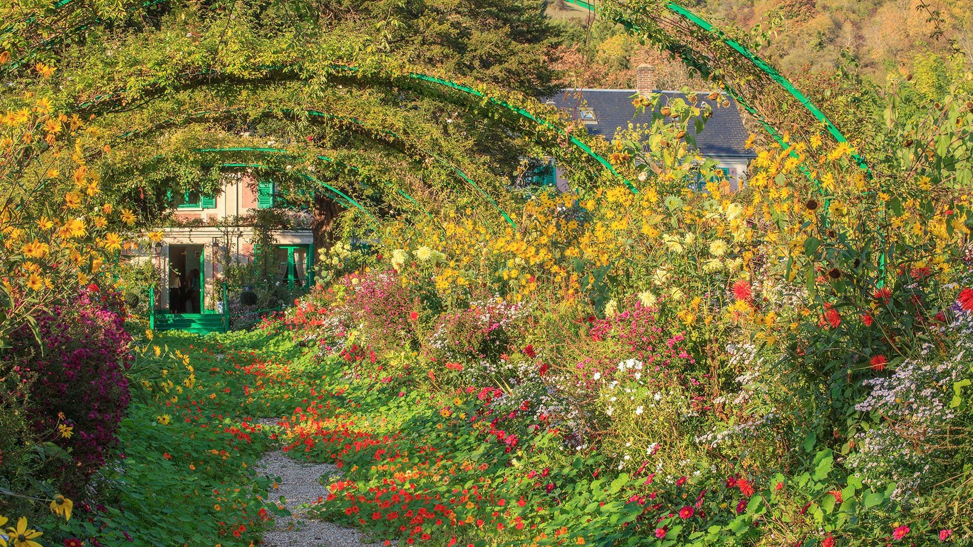
Giverny, Claude Monet garden, Normandy, France ©  andre quinou/Shutterstock

15. Impressionist Trail, Normandy

If you’re interested in French art, especially the Impressionists, this 50-mile (80 km) drive through Normandy is worth the time. It follows the landscapes that inspired painters like Monet, Sisley, and Renoir with riverbanks, gardens, and dramatic coastal cliffs that haven’t changed all that much. 

You’ll start in Giverny, where Monet lived and painted those famous water lilies, and trace the Seine Valley through villages and towns that still carry the quiet charm the painters fell for. Étretat, with its white cliffs, is a standout along the way. 

You’ll want a couple of days for this route—there’s plenty to walk through, especially if you want to visit Monet’s house or take a look inside his old studio.

How to drive the Impressionist Trail

Start in Giverny at the gardens, then take the D181 to Vernon. From there, follow the D313 along the Seine, and continue on the D982 past La Roche-Guyon and through Vétheuil. If you keep going, you’ll end up in Auvers-sur-Oise, where Van Gogh spent his final months. Brown “Route des Impressionnistes” signs help keep you on track.

Bicycle road trip along the spectacular Route des Grandes Alpes @ Flystock/Shutterstock

16. Route des Grandes Alpes

This is a serious mountain drive—about 425 miles (684 km) from Lake Geneva to the Mediterranean, crossing 16 high passes, including Col de l'Iseran, which tops out at 9,068 feet (2,764 meters). It’s a trip for people who like to drive, hike, or just be surrounded by mountain scenery. 

The landscape shifts dramatically—from alpine peaks and meadows to warmer, Mediterranean views as you get closer to the coast. You’ll pass through towns like Chamonix and Briançon, and traditional villages where you can stop for local cheese or a café lunch. Plan on 5–7 days to make the most of it, especially in summer or early fall when the passes are clear and the roads less busy.

How to drive the Route des Grandes Alpes

Start the France road trip in Thonon-les-Bains and follow the D902 south toward Morzine and the Col des Gets. Keep following the route through Chamonix, Bourg-Saint-Maurice, and other alpine towns. The drive ends in Menton, where the mountains finally give way to the sea. A car with decent power helps for the steeper stretches, especially if you're driving in higher elevations.
 

The ochre-red village Roussillon, Provence, Luberon, Vaucluse, France © Shutterstock

17. Luberon Villages loop

This 55-mile (90 km) drive through the Luberon region is one of the best road trips in France for slow travel—small stone villages, winding roads, lavender fields, and vineyards. 

The loop links up towns like Gordes, Roussillon, Bonnieux, and Lacoste, all perched on hills with wide valley views. Each one has its own feel, but expect narrow streets, old stone buildings, and little cafés where you can sit under the trees for lunch. 

There are weekly markets, hiking trails, and plenty of places to stop for wine or olive oil tastings. You could drive it in a day, but 2–3 days gives you enough time to actually enjoy the towns rather than rushing through them.

How to drive the Luberon Villages loop

Start in Cavaillon and take the D2 to Gordes. From there, drive the D177 to Roussillon, then follow the D104 to Bonnieux and Lacoste. The loop wraps back around to Cavaillon via the D36 and D943. If you're going in summer, it’s worth knowing it can get crowded. Spring and early fall tend to be a bit quieter and more comfortable for walking around.
 

Dre Roelandt

written by
Dre Roelandt

updated 18.06.2025

Dre Roelandt is originally from the United States but lives and works in Berlin, Germany. Dre is a freelance writer and artist with a passion for travelling. They are an in-house Senior Content Editor at Rough Guides.

Planning your own trip? Prepare for your trip

Use Rough Guides' trusted partners for great rates