The best things to do in New Zealand

Select Month

plan my trip

Year after year, New Zealand ends up near the top of people’s travel lists—and it makes sense. Just about everyone who goes comes back with stories of wild coastlines, wide beaches, dense forests, snow-covered mountains, and steaming geothermal areas. It’s a place that’s hard to forget. Here are a few of the best things to do in New Zealand that you won’t want to miss while you're there.

1. Visit the stunning fiord of Milford Sound

Milford Sound is the most northerly of the fifteen fiords in Fiordland and probably the most well-known. It’s surrounded by steep cliffs that rise up to 3,900 feet (1,200 meters), and there are waterfalls dropping straight down from the hanging valleys above. It’s part of Fiordland National Park, on the South Island, and is one of the easiest fiords to access without needing a boat or multi-day hike.

It’s striking in clear weather, and when it rains—which it often does—you’ll see even more waterfalls coming down the cliffs. The mist and cloud can make it feel even more dramatic.

How to get to Milford Sound

You can drive from Queenstown or Te Anau. From Te Anau, it takes about 2.5 hours; from Queenstown, expect a full-day trip. If you’d rather not drive, plenty of coach tours include a boat cruise through the fjord. Some people book scenic flights from Queenstown too—it’s pricey, but the views are something else. If you’re self-driving in the summer, it’s worth arriving early—parking can be tight.

When to visit Milford Sound

It’s good year-round. In summer (December through February), the days are longer and the weather tends to be more settled. Winter (June through August) brings snow on the peaks and fewer people around. If you’re hoping to see the waterfalls at their best, go during or right after a rain. 
 

milford-sound-new-zealand-shutterstock_714301276

Milford Sound, Fiordland National Park, New Zealand © Shutterstock

2. Take a ride on the Taieri Gorge Railway

The Taieri Gorge Railway runs for 72 miles (116 km) northwest of Dunedin, cutting through rugged hill country that’s otherwise hard to get into. Built between 1879 and 1921, the line used to stretch all the way to Cromwell—about 146 miles (235 km)—and was mostly used to transport supplies inland during the gold rush era.

Commercial use stopped in 1990, but it’s still in great shape and now runs as a scenic railway. The train includes both modern steel carriages with large panoramic windows and older, refurbished wooden cars from the 1920s that give you more of a classic train feel.

How to get to Taieri Gorge Railway

Trains leave from Dunedin’s old railway station right in the center of town. Most rides start there, though some tours include hotel pickup.

Book in advance if you’re going during summer. You can choose between shorter half-day trips or full-day journeys, depending on how much time you have. 

When to visit Taieri Gorge Railway

It runs all year, and what you see depends on when you go. Autumn (March to May) brings golden leaves, and spring (September to November) is all fresh green hills and wildflowers. In summer, there are more departures. In winter, it can feel quieter and sometimes you’ll get a bit of snow in the landscape. 
 

View of yellow train riding through Taireri Gorge in New Zealand © LanaG/Shutterstock

Taireri Gorge in New Zealand © LanaG/Shutterstock

3. Whale watch off of the Kaikoura Peninsula

 If seeing whales is on your list, Kaikōura is a reliable place to do it. Just off the coast, the Kaikōura Canyon drops down to about 3,300 feet (1,000 meters), which pulls in a mix of subtropical and sub-Antarctic waters. That combination attracts a wide range of marine life.

Sperm whales live here year-round, and depending on the season, you might also see dusky dolphins, humpbacks, or orcas. Most people go out by boat, but helicopter tours are also an option if you want to get a wider view of both the whales and the coastline.

How to get to Kaikoura

Kaikōura is about halfway between Christchurch and Picton on the South Island’s east coast. Most people drive along State Highway 1—it takes around 2.5 hours from Christchurch. There are also regular buses that connect Kaikōura with major towns and cities. 

When to visit Kaikoura

Sperm whales stick around all year, so you’ve got a consistent chance of seeing them no matter when you visit. Summer (December to February) brings the highest diversity of marine life, including migratory species like humpbacks, blue whales, and orcas. Winter (June to August) usually means quieter tours and snow-covered mountains in the distance. 
 

Whale shark in Ningaloo Reef, Australia © Sean Steininger/Shutterstock

Whale watching is one of the best things to do in New Zealand © Sean Steininger/Shutterstock

4. Cycle along the Otago Central Rail Trail

 This 93-mile (150 km) trail runs along a former railway corridor through Central Otago. It’s completely car-free, with a steady, easy gradient that never gets steeper than 2%. 

You’ll ride through tunnels, cross old viaducts, and pass preserved railway stations while cutting through wide-open landscapes. Along the way, you’ll see old gold mining relics and get a feel for rural New Zealand.

How to get to the Otago Central Rail Trail

The route runs between Clyde and Middlemarch. Clyde is the more common starting point—it’s about an hour’s drive from Queenstown. You can also get there by bus or through one of the shuttle services that run between Queenstown or Dunedin and the trail. 

If you don’t have your own gear, there are bike rental companies that can sort out bikes, accommodation, transport, and even luggage transfers. 

When to visit the Otago Central Rail Trail

Spring (September to November) and autumn (March to May) usually bring the most comfortable cycling weather, with mild temperatures and changing scenery.

Summer (December to February) means long daylight hours, but it can get really hot in areas with no shade. Fall is especially scenic, with golden poplar trees lining sections of the ride.
 

otago-peninsula-new-zealand-shutterstock_84066826

Otago trail of the South Island © Shutterstock

5. Visit the otherworldly White Island

 White Island (Whakaari) is New Zealand’s most active marine volcano, sitting about 30 miles (48km) offshore in the Bay of Plenty.
It’s known for its dramatic landscape—steaming vents, bubbling mud pools, acid streams, and a crater lake. The ecosystem is unusual, too, with bacteria adapted to extreme conditions and rich marine life in the surrounding waters.

How to get to White Island

Tours leave from Whakatāne, which is about a one-hour drive from Rotorua or around 1.5 hours from Tauranga. You can visit by guided boat tour, and some companies also run helicopter trips. 

Because of the volcanic activity, you can’t go independently—you’ll need a certified guide. Most tours take about six hours round trip. 

When to visit White Island

Summer and early autumn (December to April) usually mean calmer seas, which helps lower the chance of cancellations. Volcanic activity also changes throughout the year, so it’s important to check the current alert level before booking. 
 

Group of tourists on White Island, New Zealand © patjo/Shutterstock

This volcanic island is a fantastic spot for outdoor adventures © patjo/Shutterstock

6. Take a tour of Ninety Mile Beach

 Ninety Mile Beach (Te Oneroa-a-Tōhē) is a long, straight stretch of sand on the west coast of the Aupouri Peninsula in Northland. 

Despite the name, it’s about 55 miles (88 km) long. The beach doubles as a public highway and is backed by towering sand dunes—some more than 300 feet (100 m) high. 

It’s also a place of cultural importance to local Māori communities. People come here for things like sandboarding and surfcasting for snapper.

How to get to Ninety Mile Beach

You’ll want to base yourself in Kaitaia, the closest town, which is around a four-hour drive north of Auckland. From there, you can book a guided tour in a specially adapted vehicle that can handle the beach conditions. 

Tours also run from Paihia in the Bay of Islands. If you're thinking about driving yourself, make sure you’ve got a proper 4WD and that you’re confident driving on sand. It's essential to check the tides first—the beach is only safe to drive on at low to mid tide.

When to visit Ninety Mile Beach

Summer (December to February) has the warmest weather and is the most active time for swimming and sandboarding, but it’s also the most crowded. Autumn (March to May) is a bit quieter and still warm enough to spend time outdoors. 

Winter (June to August) tends to be stormier, but the beach takes on a more dramatic feel, and there are fewer people around—great for long walks and fishing.
 

ninety-miles-beach-new-zealand-shutterstock_1083798599

Ninety Mile Beach on New Zealand's west coast © Shutterstock

7. Stroll along the Moeraki Boulders

 The Moeraki Boulders are large, spherical rocks scattered along Koekohe Beach on the Otago coast. 
They’re around 60 million years old and were formed from ancient seafloor sediments that hardened and cracked over time. Some of the boulders have split open to reveal yellow calcite crystals. 

According to Māori legend, they’re the remains of eel baskets and food containers that washed ashore after the wreck of the ancestral canoe Arai-te-uru. 

How to get to Moeraki Boulders

The boulders are about an hour’s drive north of Dunedin on State Highway 1. Look for the turnoff between the towns of Hampden and Palmerston—it’s clearly signposted. There’s a car park nearby and a short walking path that leads down to the beach. It can get slippery, especially at low tide, so sturdy shoes help. 

When to visit Moeraki Boulders

Low tide is the best time to go since more of the boulders are exposed. Winter (June to August) tends to be quieter, but it can be chilly. Summer (December to February) is warmer but draws more visitors, so try going early in the morning to avoid the crowds. 
 

Moeraki Boulders

Moeraki Boulders at low tide, New Zealand © travellight/Shutterstock

8. Climb Fox Glacier or Franz Josef Glacier

Fox and Franz Josef are two of the most accessible glaciers in the world, with ice that flows from the Southern Alps right down into temperate rainforest—just about 1,000 feet (300 m) above sea level. 

What makes them unusual is that, unlike most glaciers, they sometimes advance as well as retreat, which means the terrain is always shifting. You’ll find blue ice caves, deep crevasses, and dramatic ridges that change from season to season.

Because the ice is unstable, walking on the glacier is only allowed with a guide. Helicopter trips are a common way to land directly on the ice and explore from there. If you’d rather stay grounded or save money, you can take free walking trails that get you close enough to see the glacier from below. Though you won’t be able to step onto the ice itself, these are easily some of the best hikes in New Zealand.

The surrounding area is part of a World Heritage site, so beyond the glaciers, there’s a mix of ecosystems—rainforest, alpine meadows, and wetlands—all within a short distance.

How to get to Fox and Franz Josef Glaciers

You’ll find both glaciers on the West Coast of the South Island, off State Highway 6. The towns of Franz Josef and Fox Glacier are small but have accommodation and food options, and both are near trailheads and tour operators. Due to recent glacial retreat and safety risks, you’ll need to book a guided trip if you want to access the ice. 

When to visit Fox and Franz Josef Glaciers

Winter (June–August) tends to have more stable conditions and clearer blue ice, although the weather can be wet and some days might be cancelled due to rain. Spring and autumn (March–May and September–November) are quieter and generally still workable weather-wise. 

Franz-Josef-glacier-new-zeland-shutterstock_8613391

Franz Josef Glacier, South Island, New Zealand © Dan Breckwoldt/Shutterstock

9. Discover the vast sands of Farewell Spit

Farewell Spit is a long sweep of sand—around 22 miles (35km)—that curves out into the Tasman Sea at the northern tip of the South Island. It’s New Zealand’s longest sandspit and a key wetland for migratory birds, with more than 90 species passing through, including waders that fly in from Siberia and Alaska.

The area also has historical and cultural importance. Māori used it for seasonal food gathering, and the name “Farewell” comes from the fact that it was the last bit of land seen by European ships leaving the country. The huge dunes, some more than 65 feet (20m) tall, create a landscape that feels more like a desert than a coastal walk.

How to get to Farewell Spit

The spit is accessed via the town of Collingwood in Golden Bay, about 2.5 hours' drive from Nelson. You can walk the first 2.5 miles (4km) independently from Wharariki Beach, but the rest of the area is protected and only accessible by booking a guided eco-tour. 

These use specially built vehicles that can drive on sand and through tidal flats. Birdwatchers should bring binoculars, and it’s worth checking Department of Conservation (DOC) advice before your visit—some areas are off-limits depending on bird activity.

When to visit Farewell Spit

Spring and autumn (September–November and March–May) are the best times for birdwatching, especially if you're hoping to see migratory species. January and February bring warmer weather for walking and swimming.
 

farewell-spit-new-zealand-shutterstock_411277807

Farewell Spit, South Island — one of the best things to do in New Zealand @ Shutterstock

10. Explore The Catlins—one of the best things to do in New Zealand

The Catlins is a rugged coastal region tucked into the southeastern corner of the South Island. It’s a good place to get off the main tourist trail—known for windswept beaches, dense rainforest, waterfalls, and wildlife. The area is quiet, and you’ll mostly be driving between short trails, scenic lookouts, and small rural towns.

Wildlife is a big draw here. You might see yellow-eyed penguins (one of the rarest penguin species), New Zealand sea lions, and Hector’s dolphins near the shore. Popular stops include Nugget Point Lighthouse and Purakaunui Falls, all of which are easy to reach by car and short walk.

How to get to The Catlins

The Catlins lies along the Southern Scenic Route between Dunedin and Invercargill. Driving is really the only way to explore it—there’s no reliable public transport, and some of the roads are unsealed, so take it slow and allow extra time. Plan for at least 2–3 days if you want to see the area properly. 

When to visit The Catlins

The best time to visit is between November and April, when the weather is generally mild and the days are longer. Summer (December–February) is ideal for seeing wildlife—penguins tend to return to shore in the late afternoon, and sea lions can be seen year-round. March and April bring nice autumn colors and fewer people

Elephant seals © Kris Clifford/Shutterstock

New Zealand fur seals relax on the beach © Shutterstock

11. Take a dive at Poor Knights Islands

 The Poor Knights Islands are one of the better-known marine reserves in New Zealand, and with good reason. They're about 14 miles (23 km) off the Tutukaka Coast and are only accessible by boat. The underwater landscape is shaped by the islands’ volcanic past—think caves, archways, tunnels, and cliffs that drop straight down.

Because of warm currents from the north, you'll find an unusual mix of subtropical and temperate marine life here—over 125 fish species, many of which don’t normally turn up in New Zealand.

There’s also a lot of color: sponges, anemones, and big forests of kelp swaying with the tide. It's a protected area, so the marine life is in good shape. Even if you’re not diving, there’s plenty to see on a snorkel or from a glass-bottom boat.

How to get to Poor Knights Islands

You’ll need to make your way to Tutukaka, about 30 minutes from Whangārei by car. From there, boats to the islands take around 45–60 minutes. Dive and snorkel trips run regularly, especially in the warmer months, and it’s best to book ahead in summer.

Gear rental is available, and if you're diving, make sure to bring your certification. Beginners can usually join a guided dive, and snorkeling is open to everyone.

When to visit Poor Knights Islands

The best time to go is between December and May. Water temperatures usually reach 68–72°F (20–22°C), and visibility often exceeds 100 feet (30 meters). February and March tend to be the calmest. 

In winter (June–August), the water drops to around 59–63°F (15–17°C), so you’ll need a thicker wetsuit. Weekdays are generally quieter, and trips can be cancelled if the weather’s rough, so keep an eye on the forecast.
 

Poor-Knights-Islands-diving-new-zealand-shutterstock_1278390523

Diver swimming through a sea cave near Poor Knights Islands, North Island, New Zealand © Danita Delmont/Shutterstock

12. Relax at rural Hokianga Harbour

Hokianga Harbour sits on the west coast of Northland and has a much slower pace than many other places in the country. The harbor holds deep cultural meaning—it’s known as “the returning place” in Māori and is linked to Kupe, the Polynesian navigator who first arrived in Aotearoa.

The area feels local. You’ve got tiny towns like Opononi and Omapere, big golden sand dunes on the north side of the harbor, and ancient kauri forests just inland. There’s a mix of Māori and European settler history here and a small but active arts community—local craftspeople, painters, and weavers all living and working in the area. It’s the kind of place where you spend your time walking along the harbor, visiting a local gallery, or watching the light change over the water.

How to get to Hokianga Harbour

It’s about a 3-hour drive north of Auckland along State Highway 12. The main access points are the towns of Opononi and Omapere. If you’re flying in, Kerikeri is the closest airport, but you’ll still need to rent a car. 

Public buses from Auckland reach as far as Rawene, though you’d need a taxi or shuttle from there. Many travelers include Hokianga as part of a Kauri Coast road trip through Northland.

When to visit Hokianga Harbour

November through April is generally the best time to go. The weather’s more settled, temperatures are mild, and it’s a good season for beach walks and getting out into the forest. Summer weekends see a few more people around, but it never feels overrun. 

For quieter days and misty mornings over the harbor, March and April are good picks. Winter brings more rain and dramatic skies—better for those looking for downtime, writing, or just relaxing indoors.
 

Omapere and Hokianga Harbour, Omapere, Northland Region, New Zealand ©  imageBROKER.com/Shutterstock

Omapere and Hokianga Harbour, Omapere, Northland Region, New Zealand © imageBROKER.com/Shutterstock

13. See the many landmarks of the rebuilding Christchurch

Christchurch has changed a lot since the earthquake in 2011. The rebuild has given the city a fresh feel, but it hasn’t erased the past. You’ll see reminders of what happened, like the 185 Empty Chairs memorial, alongside newer structures like the Tūranga central library, which was designed with public gathering in mind.

The Transitional Cathedral—often called the Cardboard Cathedral—was built using cardboard tubes and shipping containers and has become one of the city’s most talked-about buildings. There’s also a big focus on art now. Whole walls across the central city have been turned into canvases, with local and international street artists painting large-scale works as part of the post-quake transformation.

How to get to Christchurch

Christchurch International Airport has direct flights from Australia and other cities in New Zealand. From the airport, the Metro #29 bus connects to the central city, or you can pick up a rental car. Once downtown, it’s easy to explore on foot. The historic tram runs a loop that connects many of the city’s main attractions if you’d prefer not to walk.

When to visit Christchurch

Summer (December–February) is a good time for riverside cafés and the Botanic Gardens, which are in full bloom. In autumn (March–May), the trees in Hagley Park put on a show of color. Winter (June–August) can be cold, but it's also the time for events like the Botanic D’Lights, and it’s close enough to Mt. Hutt if you're looking to ski.
 

Bridge of Remembrance in the cloudy day. The landmark located in the city centre of Christchurch, New Zealand © cozyta/Shutterstock

Bridge of Remembrance.The landmark located in the city centre of Christchurch, New Zealand © cozyta/Shutterstock

14. Surf and more at Raglan

Raglan is best known for its surf, but the town itself has a distinct vibe—creative, laid-back, and environmentally conscious. Manu Bay is a world-famous left-hand break made popular in The Endless Summer, and experienced surfers travel here just for that wave. But even if you’re not surfing, Raglan’s black sand beaches, coastal walking tracks, and small-town charm make it easy to enjoy a slower pace.

The local community leans toward sustainability and the arts, with lots of handmade goods, recycled materials, and plant-based cafes.

Just outside town, you’ll find Bridal Veil Falls (Waireinga), a 180-foot (55 m) waterfall with well-maintained walking paths and viewpoints. Boat trips also leave from the harbor, where you might come across dolphins, seabirds, or even orcas, depending on the time of year.

How to get to Raglan

Raglan is around a two-hour drive south of Auckland. If you're coming from Hamilton (about 45 minutes away), regular shuttle services run between the two. The final stretch is a winding coastal road with great views, so if you can, rent a car for flexibility. 

There’s no public transport directly to Raglan, but some accommodations include local shuttle service. Surf schools often provide transport to different breaks as part of their lessons.

When to visit Raglan

If you're here to surf, the best swell usually rolls in during winter (June to August), but you’ll need a proper wetsuit—the water’s cold. Summer (December to February) is better for beginners, with smaller waves and warmer conditions. Spring and autumn (March–May and September–November) fall somewhere in between, with a mix of decent surf, fewer crowds, and milder temperatures.
 

surfing-raglan-new-zealand-shutterstock_1139909162

Surfing Raglan, surf New Zealand © Shutterstock

15. Visit the beaches of Abel Tasman National Park

Abel Tasman National Park is known for its easy access to nature, with golden beaches, temperate rainforest, and calm, clear water all in one place. It’s one of the few areas where you can kayak with fur seals in the morning and hear native birds like tūī and kererū calling through the bush by afternoon.

The coastline is dotted with coves and quiet inlets, many of which are only accessible by foot or water taxi. The park is also home to several sites with cultural importance, especially around Tōtaranui, where Māori communities once lived in fortified pā (villages) and gathered food from the land and sea. This is where you’ll find some of the best beaches in New Zealand.

How to get to Abel Tasman National Park

You can access the park from the south via Marahau or from the north via Totaranui. Both are reachable from Nelson or Motueka by road. Water taxis leave regularly from Kaiteriteri and Marahau and work well for people walking sections of the coastal track or getting to more remote beaches. These often run on a hop-on-hop-off basis, but it’s best to book in advance.

When to visit Abel Tasman National Park

This region gets some of the highest sunshine hours in the country, so October through April is generally a good time to go. Summer (December to February) is the busiest. March and April are slightly cooler but less crowded. Because of the large tidal shifts here, it’s important to check tide charts when planning walks or kayak trips, especially if you're crossing estuaries.


Abel Tasman National Park © Jiri Foltyn/Shutterstock

The beaches of Abel Tasman National Park © Jiri Foltyn/Shutterstock

16. Take a wine tour

Wine is a big part of New Zealand’s food and drink culture, especially white wines like Sauvignon Blanc, Chardonnay, and Riesling. Whether you’re into full-day tastings or just want to relax with a glass overlooking the vines, it’s easy to spend time in one of the country’s main wine regions—Hawke’s Bay, Martinborough, Marlborough, and Central Otago are some of the most well-known.

You’ll find everything from large commercial wineries to small, family-run estates. Some places require a booking, especially the boutique operations, but many welcome walk-ins during busy months. Alongside the wine, many vineyards also serve food—anything from light platters to full lunches.

How to get to New Zealand’s wine regions

Most wine regions are a short drive from nearby cities or towns. Marlborough is close to Blenheim, and Central Otago’s vineyards are spread throughout the area around Queenstown and Cromwell. If you don’t want to drive, guided tours are available in most regions and usually include transport between wineries. 

This is especially helpful if you're planning to do several tastings. For a more in-depth experience, you can also hire a local guide who knows the smaller producers that aren’t usually open to the public.

When to visit New Zealand’s wine regions

Harvest runs from February to April, and it’s a lively time to visit—with workers in the fields and occasional events marking the new vintage. Summer (December to February) has the warmest weather and is great for outdoor tastings and vineyard picnics. Winter (June to August) is quiet, but if you're more interested in conversation than crowds, it can be a good time to chat with winemakers who aren’t as busy.
 

Marlborough, New-Zealand vineyard ©  Jeffrey B. Banke/Shutterstock

Going wine tasting is one of the best things to do in New Zealand © Jeffrey B. Banke/Shutterstock

17. See the art deco architecture of Napier

Napier is a laid-back seaside city in Hawke’s Bay, with a population of around 60,000. It’s known for its warm, dry climate, relatively affordable prices, and one of the best-preserved collections of small-scale Art Deco buildings anywhere. After a major earthquake in the 1930s, much of the town was rebuilt in this distinctive style—and that character still defines the city today.

There’s a long stretch of seaside hotels and a decent mix of restaurants in town, so it works well as a base. From here, you can head out to see the gannet colony at Cape Kidnappers, spend a day wine tasting at local vineyards, or try sea kayaking or jet boating.

How to get to Napier

You can fly into Hawke's Bay Airport from Auckland or Wellington—flights are regular, and the airport is just a 10-minute drive from the city center. If you're driving, it’s around 4 hours from Wellington or 5 from Auckland on well-maintained highways. 

When to visit Napier

February is a good time to visit if you want to catch the annual Art Deco Festival, which fills the streets with vintage cars, period dress, and outdoor events. Autumn (March to May) brings fewer visitors and cooler weather, plus it's harvest season in the vineyards. 
 

Art deco architecture of Napier, New Zealand © Henryk Sadura/Shutterstock

Art deco architecture of Napier, New Zealand © Henryk Sadura/Shutterstock

18. Walk the Routeburn Track

The Routeburn Track is a multi-day trail that connects Mount Aspiring National Park to Fiordland, running through some pretty remote alpine landscapes. 

Even though it’s not the longest of New Zealand’s Great Walks, it covers a lot of terrain—forested valleys, big waterfalls, rivers, and alpine passes. It’s also one of the better tracks for birdlife, with a decent chance of seeing native species like the mohua.

How to get to the Routeburn Track

There are two access points: the Routeburn Shelter near Glenorchy (about 45 minutes from Queenstown) and The Divide on the Milford Road. Most hikers arrange a shuttle from Queenstown or Te Anau, starting at one end and finishing at the other without needing to backtrack. It’s a popular walk, so booking your hut accommodation with the Department of Conservation in advance is essential.

When to visit the Routeburn Track

The main season runs from late October to April, when huts are fully serviced and have resident wardens. December to February gives you the longest daylight hours and generally more stable weather.
 

Key Summit, Routeburn track, Milford Sound, New Zealand © LauraMcCarthy/Shutterstock

Routeburn Track, the south west of South Island © LauraMcCarthy/Shutterstock

19. See Wai-O-Tapu of North Island

Wai-O-Tapu is one of the more colorful geothermal areas near Rotorua. It’s a self-guided loop walk that takes around an hour, and you’ll pass all kinds of unusual features—bright mineral pools, bubbling mud, and steaming vents that give the place a bit of an otherworldly feel.

Some of the main things to look for are the Devil’s Ink-Pots (basically boiling mud), the Artist’s Palette (which changes color depending on mineral content and sunlight), and the Champagne Pool, which is probably the most photographed part—it’s round, deep green, and always steaming around the edges.

How to get to Wai-O-Tapu

Wai-O-Tapu is about 17 miles (27 kilometers) south of Rotorua, just off State Highway 5. It’s easy to get to by rental car or tour bus. The park has good parking, and the paths are manageable for most people. 

When to visit Wai-O-Tapu

Try to arrive between 8 and 9 AM to catch the daily eruption of the Lady Knox Geyser, which is timed and draws a crowd. Winter is great for dramatic steam effects thanks to the cooler air, while spring and autumn are ideal for walking. Avoid going right after heavy rain if you can—the paths can get muddy.
 

waiotapu--rotorua-new-zealand-shutterstock_203657524

The stunning mineral lakes of Wai-O-Tapu of North Island, New Zealand © Shutterstock

20. Bungee jumping in New Zealand's south island

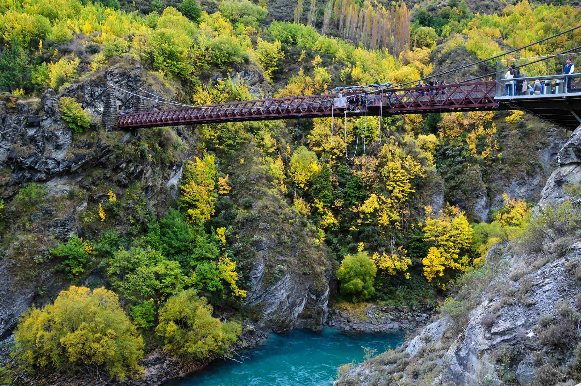
 If you're after an adrenaline rush without needing extreme experience, bungee jumping is a good way to go. New Zealand’s known for it, and the South Island has some of the most iconic jumps—like bridges stretched over deep canyons and platforms that jut out above rivers.

The Kawarau Bridge near Queenstown is where commercial bungy jumping began. It’s still going strong and is one of the more accessible jumps. Not far from there is the Nevis jump, which is higher and definitely more intense. You’ll also find a handful of other jump locations around the country, but Queenstown is definitely the main hub.

How to get to Bungy Jump Sites

From Queenstown, Kawarau Bridge is about 14 miles (23 km) away along the Gibbston Valley road. Nevis is a bit more remote—it’s around a 45-minute drive from Queenstown, plus a scenic helicopter ride or off-road shuttle to get to the platform. Most operators include transport from town, which makes things easier. 

AJ Hackett and Shotover Jet are two well-known names that run jumps here, and booking with them directly is the simplest route if you’re looking for experienced operators with safety protocols in place.

When to visit Bungy Jump Sites

The best time is during the summer months (December–February), when you’ll get the longest daylight hours and more stable conditions. Winter can bring strong winds that shut down higher jumps like Nevis, so flexibility is important. 

If you're hoping to get good photos or videos, early mornings and late afternoons have the best light. Since weather changes quickly in the mountains, check conditions close to your jump time and try to leave room in your schedule in case things shift.
 

kawarau-bridge-bungy-new-zealand-shutterstock_152290715

Bungy jumping is one of the best things to do in New Zealand© Shutterstock

21. Tongariro Alpine Crossing—one of the best things to do in New Zealand

Tongariro National Park is packed with great walks, and the Tongariro Alpine Crossing is the one that draws the most attention—for good reason. It’s a one-day trek through active volcanic terrain that packs a lot into just under 12.1 miles (19.4 km).

You’ll climb over ancient lava flows, walk across a crater floor, and pass geothermal vents and strikingly colored lakes. The landscape changes every hour or so, and the trail gives you a rare chance to walk right through a living volcanic system. It's a long day, but manageable if you're reasonably fit and come prepared.

How to get to Tongariro Alpine Crossing

Because it’s a one-way track, you’ll need a shuttle between the Mangatepopo and Ketetahi car parks. Shuttles run from nearby towns like National Park Village, Turangi, and Taupo. It’s best to book ahead, especially in high season. 

If you’re coming from Auckland, it’s about a three-hour drive to the trailhead. Make sure to wear proper hiking boots and bring layers—temperatures can drop quickly and weather changes fast. Rain gear is essential, even in summer.

When to visit Tongariro Alpine Crossing

The main season runs from October to April, when the track is clear and safer to hike. Winter hikes are possible, but only if you’ve got alpine experience and the right equipment—there’s snow, ice, and the risk of rapid weather shifts. 

Aim to start early, around 7 or 8 AM, so you have enough time to finish before it gets dark. Also, always check the volcanic alert level and weather forecast before you go, since the terrain is active and conditions can change without much warning.
 

kiwi-road-ngauruhoe-tongariro-new-zealand-shutterstock_1401414941

Tongariro Alpine Crossing, central North Island © Shutterstock

22. Soak at Hot Water Beach

 Hot Water Beach is one of those rare places where you can dig a hole in the sand and sit in your own natural hot pool—right by the ocean. It’s a popular stop on the Coromandel Peninsula, thanks to the underground hot springs that run just below the surface near the shoreline.
The geothermal water seeps up through the sand, especially near the rocky section that divides the beach in two. 

All you need is a spade and some time to find a good spot to dig. The springs can get up to 147°F (64°C), so most people mix in seawater to cool things down and create a comfortable soak. This natural heating comes from two underground springs that have been warming the sand here for thousands of years.

How to get to Hot Water Beach

Hot Water Beach is on the east coast of the Coromandel Peninsula, reached via Highway 25. The closest town is Hahei, about 4 miles (6 km) away. From Auckland, the drive takes around 2.5 hours, usually via Thames and Whitianga. 

Parking is limited and fills up quickly, especially during summer or holidays, so it’s smart to get there early. From the car park, it’s about a 5-minute walk through native bush to reach the beach. Bring your own spade, or rent one from nearby cafés or hostels.

When to visit Hot Water Beach

The hot springs are only accessible within about two hours on either side of low tide, so check the tide charts before you go. Summer (December–February) is the most popular time to visit, but it gets crowded. Shoulder seasons like April–May or September–November tend to be a bit quieter, with still-pleasant weather. Winter can be a great time to go too—digging a hot pool while the air is cold makes for a nice contrast—but conditions are less predictable and the ocean tends to be rougher.
 

Hot Water Beach, Mercury Bay, Coromandel, New Zealand © Shutterstock

Hot Water Beach, North Island, New Zealand © Shutterstock

23. Go on an outdoor adventure at Lake Taupo

23. Go on an outdoor adventure at Lake Taupo
Lake Taupo is known for trout fishing—anglers come from all over to fish for brown and rainbow trout in the lake itself and the rivers and streams that feed into it. The lake was formed by a massive volcanic eruption about 26,500 years ago, and that crater now holds New Zealand’s largest lake, covering around 238 square miles (616 square kilometers).

On the northeastern shore, Taupo town has grown into a busy little resort with easy access to the lake and nearby activities. The Waikato River starts here and flows out of the lake through a series of dramatic rapids—a good area for jet boating or just watching the water thunder past. Around the lake, you’ll find everything from thermal hot springs and hiking tracks to skydiving, bungee jumping, and scenic flights over the volcanic plateau. If you’re into fishing, the lake’s a reliable place to cast a line.

How to get to Lake Taupo

Taupo sits on State Highway 1, so driving in is straightforward—about 3.5 hours from Auckland and 4.5 hours from Wellington. InterCity runs daily buses from both cities. Once you’re in town, most things are within walking distance. If you’re heading out on the lake, many operators arrange pickups from accommodations. Taupo Airport handles domestic flights from Auckland and Wellington and is a short drive from the town center.

When to visit Lake Taupo

October through April is peak fishing season, when the trout are most active, but fishing is possible year-round. Summer (December

February) brings warm days for swimming and lake activities. Winter is quieter, with snow on the nearby mountains and good weather for soaking in hot pools. Autumn is a nice time to hike, with changing foliage and comfortable temperatures.


Rotoaira and Taupo lakes, Tongariro national park, North island of New Zealand © Shutterstock

ongariro national park, North Island of New Zealand © Shutterstock

24. Aoraki / Mt Cook National Park—New Zealand's highest mountain

Mount Cook—or Aoraki, as it’s increasingly called—stands at 12,316 feet (3,754 meters) and is New Zealand’s highest peak. The name Aoraki means “cloud piercer” in te reo Māori. It’s part of the Southern Alps and has long drawn climbers from around the world. 

The mountain is the centerpiece of Aoraki / Mount Cook National Park, which became a UNESCO World Heritage Site in 1986. There are 22 peaks in the park over 9,840 feet (3,000 meters), along with a network of walking tracks that make the landscape accessible without technical gear. 

The Tasman Glacier runs for 17 miles (27 kilometers) down the eastern side, and the area is known for its extremely clear night skies. It’s also a part of the Aoraki Mackenzie International Dark Sky Reserve.

How to get to Aoraki / Mt Cook National Park

The park is reached via State Highway 80, which turns off State Highway 8 near Twizel. From Christchurch, the drive takes about 4.5 hours. From Queenstown, it’s around 5 hours, usually passing through Wanaka. There’s no direct public transport to the park, but some operators run day tours from nearby towns. 

When to visit Aoraki / Mt Cook National Park

Summer (December–March) usually brings the most settled conditions for hiking and mountaineering, with longer daylight hours and easier access to alpine trails. 

That said, weather here can change quickly at any time of year. Winter brings snow to lower elevations, good conditions for skiing, and sometimes aurora sightings. Spring and autumn have more variable weather but fewer crowds. Some higher tracks may be closed, so it’s best to check ahead before you go.

Majestic Mount Cook, Aoraki/Mount Cook National Park © Shutterstock

Aoraki/Mount Cook, South Island, one of the best things to do in New Zealand © Shutterstock

25. Te Papa Museum for all ages

Te Papa Tongarewa, New Zealand’s national museum, is the kind of place you can visit more than once and still find something new each time. It covers everything from natural history and Māori culture to contemporary art and interactive science exhibits. A lot of displays are hands-on, so it’s well-suited for both adults and kids.

The museum sits right on the waterfront in Wellington in a purpose-built five-story building. Inside, you’ll find things like a giant preserved squid, a traditional carved meeting house, an earthquake simulator, and a wide mix of rotating exhibits—some showcasing international artists, others focusing on local history or environmental themes.

How to get to Te Papa Museum

Te Papa is on Cable Street and easy to reach by foot from downtown Wellington or the train station. If you’re driving, nearby parking is mostly paid, and free spots are limited.

When to visit Te Papa Museum

The museum is open every day except Christmas, and during school holidays it sometimes stays open later. Weekday mornings are the quietest, while weekends—especially during holidays—can be busy with families. 

Museum of New Zealand Te Papa Tongarewa in Wellington, New Zealand © Shutterstock

Capital city of Wellington, North Island, New Zealand © Shutterstock

This list could truly go on. There are countless fantastic things to do in New Zealand. Ready to start planning your trip? Check out our Rough Guides guidebooks. Read more about the best time to go, the best places to visit and best things to do in New Zealand.

If you prefer to plan and book your trip to New Zealand without any effort and hassle, use the expertise of our local travel experts to make sure your trip will be just like you dream it to be.

We may earn commission when you click on links in this article, but this doesn’t influence our editorial standards. We only recommend services that we genuinely believe will enhance your travel experiences.

Rough Guides Editors

written by
Rough Guides Editors

updated 26.06.2025

For over 40 years, Rough Guides has been a trusted name in travel, offering expert-curated guides, inspiring articles, and tailor-made trips. Our passionate team of writers and local travel specialists provide in-depth insights into destinations worldwide, from iconic landmarks to hidden gems. We help you travel smarter and experience the world authentically.

Planning your own trip? Prepare for your trip

Use Rough Guides' trusted partners for great rates