Planning your own trip? Prepare for your trip
Use Rough Guides' trusted partners for great rates
written by
Olga Sitnitsa
Trás-os-Montes means “Beyond the Mountains,” and for centuries that’s exactly how it felt. Tucked behind the serras of Gerês, Marão, and Alvão, this northeastern region was cut off from the rest of the country by geography, poverty, and a fierce sense of independence. Life here was tough, winters were colder, and local traditions took on a shape of their own.
Many left in search of work or opportunity, while others came here to hide. Jewish communities fleeing the Inquisition found refuge in the villages, leaving behind traces in surnames, architecture, and regional cooking. Change came slowly. Until the 1980s, much of the region remained untouched by tourism or development.
Today, Trás-os-Montes is better connected, with new roads and renewed towns. But it still feels apart. That distance is what gives the region its edge and its character. You don’t come here for the crowds. You come for smoke-curled hilltop villages, stone-built towns with Roman roots, and food that warms you from the inside out.

Tips from Luis
Portugal Travel Expert

Hey, I’m Luis, your Portugal travel expert. Trás-os-Montes is one of the country’s least visited regions, but it leaves a lasting impression. Tucked into the northeastern corner, it’s a place of rugged hills, chestnut forests, and stone-built villages that still follow seasonal rhythms. For a long time, it was hard to reach. That distance helped preserve its traditions, dialects, and fiercely local identity.
This guide will walk you through the essentials: how to get there, what to expect, and where to stay. But the real value of visiting Trás-os-Montes comes from slowing down. Take your time. Ask questions. Try the smoked sausage, learn a few words of Mirandese, and follow the back roads through valleys that feel almost untouched.
Luis’s tip
Skip the highway at least once. Take the N103 or the old EN2. You’ll get winding roads, sweeping valleys, and villages that never make it onto postcards. Pack snacks and take your time.
Best time to visit
Spring and autumn are ideal. April through June brings wildflowers and green hills. September and October mean grape harvests, chestnut festivals, and cool evenings. Summers can be hot and dry, especially inland, while winters are cold and often snowy at higher elevations. If you want remote landscapes and quiet towns, January and February are perfect.
How to get to Trás-os-Montes
There’s no single gateway to Trás-os-Montes, but the main hubs are Bragança, Chaves, and Miranda do Douro. The nearest airport is in Porto. From there, you can drive to Bragança in about 2 hours and 30 minutes, or to Chaves in just over 2 hours. There are no direct train services to the region’s main towns. Buses from Porto and Lisbon run daily, with Rede Expressos offering routes to Bragança, Chaves, and other regional centers. Driving is the easiest option. From Lisbon, it takes around 5 hours, and having your own car gives you far more freedom to explore the smaller villages and natural parks.
Best areas to stay in Trás-os-Montes
Trás-os-Montes is in the far northeast of Portugal, bordered by Spain to the east and the Douro River to the south. It’s a vast and rugged region of mountains, valleys, and remote highlands, home to towns like Bragança, Chaves, and Miranda do Douro.
Often overlooked by tourists, Trás-os-Montes is one of the best places to visit in Portugal if you’re looking for something different. From here, you can wander through villages in the Montesinho Natural Park, explore Roman roads and medieval castles, or follow winding backroads to the Spanish border.


Trás-os-Montes is not the kind of place you breeze through. It’s a region of mountains, valleys, and scattered stone villages, and distances that look short on a map can take much longer on the road. Public transport exists but is patchy, and the places you’ll most want to see are usually far from the main routes. For that reason, most visitors rely on a car, but there are other ways to get around if you plan carefully.
If you’re asking how many days in Trás-os-Montes are enough, plan at least three. The region is large, the roads are slow, and the real reward lies in taking your time. A short visit gives you a taste of its main towns like Bragança or Chaves, but you’ll miss the villages, natural parks, and food traditions that make the area stand out.
If you can stretch your trip, four to five days is ideal. That gives you time to explore Bragança’s walled citadel, soak in Chaves’ Roman hot springs, and venture into Montesinho Natural Park for walks through chestnut forests and stone hamlets. You can also detour to Miranda do Douro for its cathedral and dramatic gorge, or drive the almond blossom routes near Mogadouro in spring.
If you’re planning a longer Portugal itinerary, consider giving Trás-os-Montes nearly a week. With that time, you can balance city stays with rural guesthouses, sample local dishes like posta mirandesa and smoked sausages, and join in seasonal festivals. Extra nights mean you’ll see the landscape in changing light, from sunrise mist over the valleys to clear night skies unspoiled by city glow.
Trás-os-Montes covers a wide area, from border towns on the Douro to mountain villages deep in the Montesinho Natural Park. Accommodation ranges from family-run guesthouses to rural manor houses and small city hotels. Here’s where to base yourself depending on how you like to travel.
Trás-os-Montes is big, wild, and rewarding for anyone willing to slow down. It’s not about ticking boxes but about climbing castle walls, following old trails, and sitting down to steaming bowls of food that taste of the land. Here’s the in-depth list of things to do in Trás-os-Montes, each one worth taking your time over.
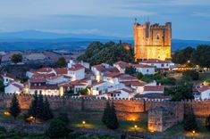
Bragança is the unofficial capital of Trás-os-Montes, and its citadel is the best place to start. Enclosed by thick medieval walls, it’s less a fortress and more a small village, with whitewashed cottages, cobbled lanes, and tiny chapels tucked between homes. The highlight is the 12th-century castle, with its imposing keep and ramparts you can still walk.
Inside, the military museum holds everything from medieval armor to World War rifles. Outside, don’t miss the Domus Municipalis, a rare Romanesque civic hall built entirely in stone. Climb the walls in the late afternoon when the sun lights up the terracotta roofs of Bragança below, and you’ll see why this remains one of the best things to do in Portugal for history lovers.
Sitting high above the Douro gorge, Miranda do Douro is a border town that feels different from the rest of Portugal. The Gothic cathedral dominates the skyline, its cavernous interior filled with gilded chapels. Step outside and the views drop sharply to the Douro River, which cuts a deep canyon between Portugal and Spain.
This is also the home of the Mirandese language, still spoken by some locals, and the traditional pauliteiros dance, where men perform energetic stick routines in full costume. The best time to see it is during village festivals in summer. Wander the old lanes, look for Jewish symbols carved on doorways, then find a terrace for a glass of wine as the sun sets over the gorge.
Chaves has been famous since Roman times for its healing waters. The Roman bridge still spans the Tâmega River with sixteen sturdy arches, while thermal springs bubble up at nearly 73°C. In the town square, you can drink the mineral-rich water from public fountains, or head to a spa for a modern soak.
Chaves is also known for its pastries, especially pastéis de Chaves, flaky meat-filled turnovers. Pair one with a stroll through the historic center, where narrow streets lead to tiled houses, baroque churches, and small gardens shaded by plane trees. A stop here mixes wellness with history in one of the most charming towns in the region.
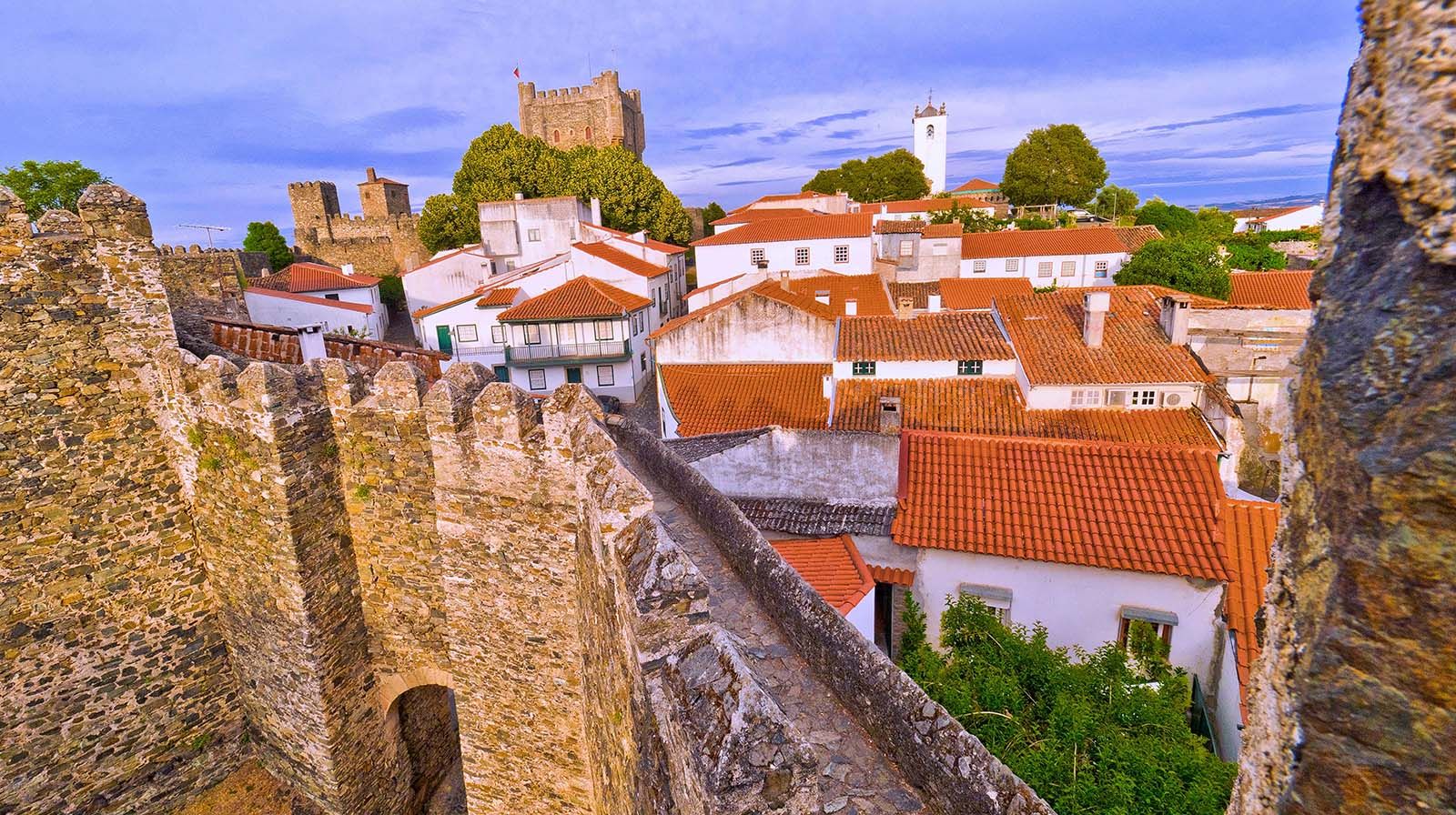
Partial view, at dusk, of the medieval citadel and the castle of Bragança in Portugal. © Shutterstock
Covering 75,000 hectares of mountains, valleys, and forests, Montesinho is one of Portugal’s wildest landscapes. Trails lead you through chestnut groves, across rivers, and into villages like Rio de Onor, where Portuguese and Spanish families still share communal ovens and pastures.
Wildlife lovers come hoping to glimpse deer, wild boar, or even Iberian wolves. Birdwatchers can spot golden eagles and vultures riding thermals above the ridges. Bring sturdy boots and plan at least half a da: this is one of the best hikes in Portugal if you want solitude, authentic villages, and landscapes that still feel untouched.
Food in Trás-os-Montes is rustic, filling, and built around pork. Winter is the season of the matança do porco, when families gather to cure meats and make sausages. The result fills markets year-round: smoky alheiras, garlic-rich chouriça, and butelo, a pork sausage often paired with beans.
In Bragança and Vinhais, butcher shops display strings of sausages drying above counters, and you’ll often be offered a slice before you buy. Pair them with strong red wines from nearby Trás-os-Montes vineyards or simply eat them with bread and cheese in a village tasca.
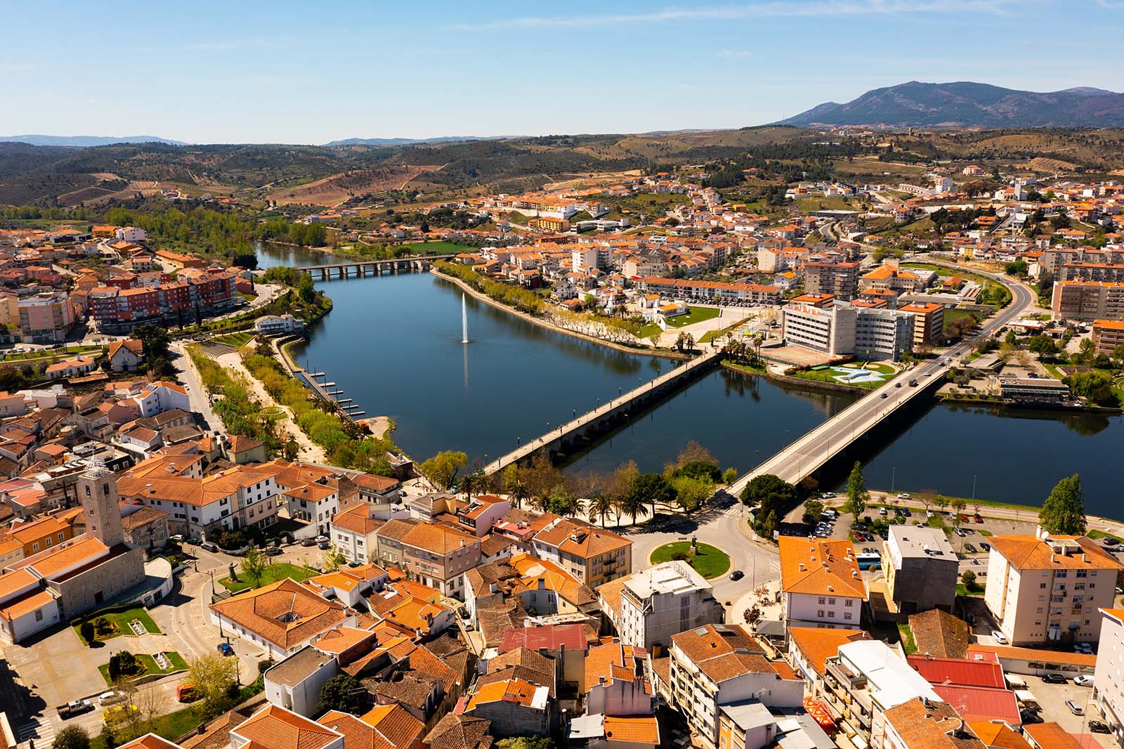
Mirandela, on the banks of the Tua River, is quieter than Bragança or Chaves but worth a stop for its food and olive oil. The old bridge links both sides of town, where gardens and river walks make for an easy afternoon.
The surrounding hills are covered in olive groves, and you can visit small producers for tastings. If you’re here in July, the town hosts the Festa da Alheira, celebrating its most famous sausage with food stalls, music, and fireworks.
Trás-os-Montes is a land of festivals tied to the seasons. In autumn, magustos (chestnut roasts) bring locals together around bonfires, chestnuts, and young wine. In spring, the almond blossom transforms valleys near Mogadouro and Torre de Moncorvo into seas of white and pink, marked with hikes and food fairs.
Winter brings Carnival, most famously in Podence, where masked figures known as Caretos chase villagers with cowbells in chaotic parades.
On the edge of the Douro, Lamego’s baroque sanctuary of Nossa Senhora dos Remédios is a pilgrimage site reached by a monumental staircase of 686 steps. The climb passes fountains, statues, and azulejo panels, each level offering wider views over vineyards and the tiled roofs of the town.
You don’t have to climb from the bottom; you can drive partway up, but if you take the full route, plan for about 30 minutes of steady steps. The sanctuary at the top is ornate, but the real reward is the panorama across the Douro hills.
From Miranda do Douro, boats glide through the Douro gorge, where cliffs tower hundreds of meters above the river. The silence is broken only by birds of prey, griffon vultures, golden eagles, circling overhead. Guides explain the geology and wildlife, while the boat slides past hidden caves and ancient terraces.
Cruises last about an hour and are best in spring or autumn when the light is soft and the crowds are thinner. It’s one of the most dramatic landscapes in northern Portugal, and the contrast with the cultivated Douro Valley further west couldn’t be starker.
Beyond the main towns, the heart of Trás-os-Montes lies in its villages. Vinhais is known for its smoked ham, Carrazedo de Montenegro for chestnuts, and Podence for its Carnival figures. Many still have communal bread ovens and stone houses blackened with age.
The joy is in wandering without a plan. Sit on a bench, greet neighbors, buy bread still warm from a wood-fired oven. In winter, woodsmoke curls above rooftops, and in summer, the fields ring with the sound of cicadas.
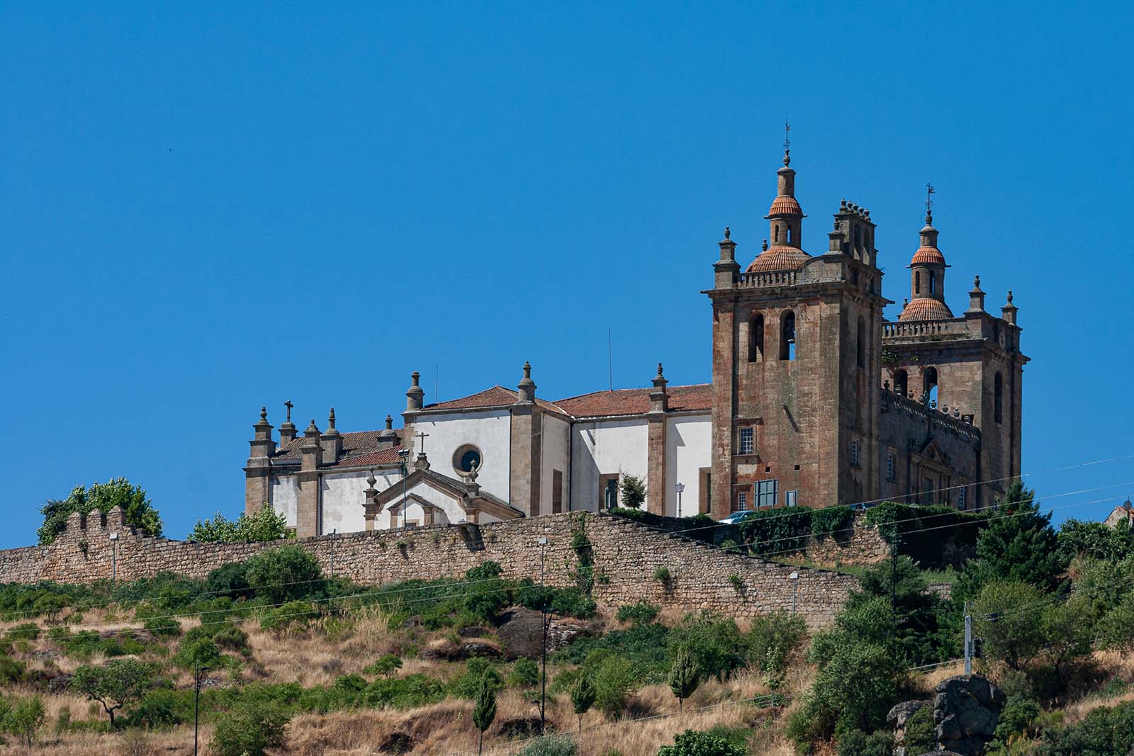
The Miranda do Douro Church © Shutterstock
Trás-os-Montes has a continental climate, shaped by its mountains and distance from the coast. Summers are hot and dry, winters are cold and often snowy at higher elevations, and temperature swings between day and night are bigger than along the coast. Average temperatures range from 39°F (4°C) in January to 86°F (30°C) in August, though heatwaves can push it above 95°F (35°C) in summer and winter nights can dip below freezing. For current conditions, check IPMA (Portuguese Institute for Sea and Atmosphere).
Food in Trás-os-Montes is hearty, rustic, and deeply tied to the land. Expect smoked sausages, fire-grilled beef, chestnuts in everything from soups to desserts, and thick slices of regional bread. Meals are generous, flavors are bold, and meat is at the heart of most plates. In winter, tasquinhas (small taverns) smell of woodsmoke and slow-cooked stews, while summer brings outdoor feasts and festival food stalls.
Picturesque aerial view of Mirandela city © Shutterstock
Here are some unique experiences we can arrange for your tailor-made Trás-os-Montes trip: all private, flexible, and designed by our local travel experts.
Use Rough Guides' trusted partners for great rates
written by
Olga Sitnitsa